Shoal Lake 40

Last updated

Shoal Lake 40
Shoal Lake Indian Reserve No. 40
Canada location map 2.svg
Red pog.svg
Shoal Lake 40
Coordinates: 49°37′N95°09′W / 49.617°N 95.150°W / 49.617; -95.150
Country Flag of Canada (Pantone).svg  Canada
Provinces Flag of Ontario.svg  Ontario, Flag of Manitoba.svg  Manitoba
District /
Division
Kenora / Division 1
First Nation Shoal Lake 40
Area
  Land26.21 km2 (10.12 sq mi)
Population
 (2011) [1] [2]
  Total101
  Density3.9/km2 (10/sq mi)
Website www.shoallake40.ca

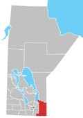
Shoal Lake 40 is a First Nations reserve straddling the border of Manitoba and Ontario on the shores of Shoal Lake. It is one of the reserves of the Shoal Lake 40 First Nation.

Related Research Articles

<span class="mw-page-title-main">Cochrane District</span> District in Ontario, Canada

Cochrane District is a district and census division in Northeastern Ontario in the Canadian province of Ontario. It was created in 1921 from parts of Timiskaming and Thunder Bay districts.

<span class="mw-page-title-main">Alnwick/Haldimand</span> Township in Ontario, Canada

The Township of Alnwick/Haldimand is a township in central Ontario, Canada, in Northumberland County, situated between Lake Ontario and Rice Lake. It was formed in 2001 by the merger of Alnwick Township in the north and Haldimand Township in the south. Alderville First Nation is an autonomously governed First Nation contained within the township boundaries, in two non-contiguous sections along County Roads 45 and 18.

The Wahnapitae First Nation is an Ojibway First Nation band government in the Canadian province of Ontario, who primarily reside on the 1,036-hectare (2,560-acre) Wahnapitae Indian Reserve No. 11 on the northwestern shore of Lake Wanapitei. The First Nation is a signatory to the Robinson-Huron Treaty of 1850 as the Tahgaiwenene's Band. The reserve had a resident population of 102 in the Canada 2011 Census; the First Nation also has approximately 200 further registered members who currently live off-reserve.

Wawakapewin First Nation is an Oji-Cree First Nation reserve located 350 kilometers north of Sioux Lookout, Ontario. It is only accessible by air and the winter road system from Pickle Lake. It is a small community in which the registered population in June 2013 was 73, of which 43 lived on their own Reserve. The current Chief is Anne-Marie Beardy. Wawakapewin First Nation is a member of Shibogama First Nations Council.

Ginoogaming First Nation is a small Anishinaabe (Ojibway) First Nation reserve located in Northern Ontario, located approximately 40 km east of Geraldton, Ontario, Canada, on the northern shore of Long Lake, immediately south of Long Lake 58 First Nation and the community of Longlac, Ontario. As of September, 2006, their total registered population was 773 people, of which their on-Reserve population was 168.

<span class="mw-page-title-main">Division No. 1, Manitoba</span> Census division in Manitoba, Canada

Division No. 1 is a census division located within the Eastman Region of the Canadian province of Manitoba. Unlike in some other provinces, census divisions do not reflect the organization of local government in Manitoba. These areas exist solely for the purposes of statistical analysis and presentation; they have no government of their own.

Shoal Lake 40 First Nation is an Ojibway or Ontario First Nation reserve located in the Eastman Region of Manitoba and the Kenora District of Ontario. The total registered population in December 2022 was 683, of which the on-reserve population was 306. The First Nation is a member of the Bimose Tribal Council, a Regional Chiefs' Council that is a member of the Grand Council of Treaty 3.

<span class="mw-page-title-main">Black Lake Denesuline First Nation</span>

Black Lake is a Denesuline First Nations band government in the boreal forest of northern Saskatchewan, Canada. It is located on the northwest shore of Black Lake where the Fond du Lac River leaves the lake to flow to Lake Athabasca.

Division No. 1, Unorganized, or Whiteshell Unorganized, is a Statistics Canada census subdivision of its Division No. 1, Manitoba that consists of a part of the division that is not organized into either incorporated municipalities or Indian reserves. Unlike in some other provinces, census divisions do not reflect the organization of local government in Manitoba.

<span class="mw-page-title-main">Sabaskong Bay 35D</span> Indian reserve in Ontario, Canada

Sabaskong Bay 35D is a First Nations reserve on Kakagi Lake near Sioux Narrows-Nestor Falls, Ontario. It is the main reserve of the Ojibways of Onigaming First Nation.

The Montreal Lake Cree Nation is a Woodland Cree First Nation in northern Saskatchewan. The administrative centre of the Montreal Lake Cree Nation is located in the community of Montreal Lake.

<span class="mw-page-title-main">Lake Helen 53A</span> Indian reserve in Ontario, Canada

Lake Helen 53A is a First Nations reserve in Thunder Bay District, Ontario, Canada. It is one of two reserves for the Red Rock Indian Band.

Lake of the Woods 37 is a First Nations reserve consisting of four islands within Lake of the Woods. It is one of the reserves of the Northwest Angle 37 First Nation.

Rainy Lake 17A is a First Nations reserve on Rainy Lake in northwestern Ontario. It is one of the reserves of the Naicatchewenin First Nation.

Rat Portage 38A is a First Nations reserve on Lake of the Woods in northwestern Ontario. It is one of two reserves of the Obashkaandagaang Bay First Nation.

Sabaskong Bay 35C is a First Nations reserve on Lake of the Woods in northwestern Ontario. It is one of the reserves of the Ojibways of Onigaming First Nation.

Shoal Lake 39A is a First Nations reserve straddling the border of Manitoba and Ontario on the shores of Shoal Lake. It is one of the reserves of the Iskatewizaagegan 39 Independent First Nation.

Shoal Lake 34B2 is a First Nations reserve on the shores of Shoal Lake in northwestern Ontario. It is shared between the Iskatewizaagegan 39 Independent First Nation and Shoal Lake 40 First Nation.

<span class="mw-page-title-main">Shoal Lake 28A</span> Indian reserve in Canada, Shoal Lake

Shoal Lake 28A is an Indian reserve of the Shoal Lake Cree Nation in Saskatchewan. It is 92 kilometres east of Nipawin. In the 2016 Canadian Census, it recorded a population of 424 living in 115 of its 118 total private dwellings. In the same year, its Community Well-Being index was calculated at 46 of 100, compared to 58.4 for the average First Nations community and 77.5 for the average non-Indigenous community.

References

  1. 1 2 "Shoal Lake (part) 40 census profile". 2011 Census of Population . Statistics Canada. 8 February 2012. Retrieved 22 June 2015.
  2. 1 2 "Shoal Lake (part) 40 census profile". 2011 Census of Population . Statistics Canada. 8 February 2012. Retrieved 22 June 2015.