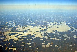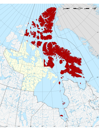
The Qikiqtaaluk Region, Qikiqtani Region or the Baffin Region is the easternmost, northernmost, and southernmost administrative region of Nunavut, Canada. Qikiqtaaluk is the traditional Inuktitut name for Baffin Island. Although the Qikiqtaaluk Region is the most commonly used name in official contexts, several notable public organizations, including Statistics Canada prior to the 2021 Canadian census, use the older term Baffin Region.

Kawawachikamach is a Naskapi/Iyiyiw First Nations reserve and community at the south end of Lake Matemace, approximately 15 kilometres (9.3 mi) northeast of Schefferville, Quebec, Canada. It belongs to the Naskapi Nation of Kawawachikamach. The village was built by the Naskapi/Iyiyiw from 1980 to 1983. The language spoken is Iyiyiw-Imuun, a dialect closely related to Innu and Iynu. The name means "the winding river".
Eastmain is a Cree community located on east coast of James Bay at the mouth of the Eastmain River, Quebec, Canada. It is a small coastal Cree village with a population of 924 people in the 2021 Canadian Census up from 866 people at the 2016 Canadian Census. Its alternate Cree name is ᐙᐸᓅᑖᐤ/Wâpanûtâw, meaning Lands east of James Bay.
Nemaska is a small Cree community located on the shores of Lake Champion, in Quebec, Canada. It is a small Cree village with a population of 832 people at the 2021 census. Nemaska is the seat of the Grand Council of the Crees and Cree Regional Authority.
The Pikangikum First Nation is an Ojibwe First Nation located on the 1,808-hectare (4,470-acre) Pikangikum 14 Reserve, in Unorganized Kenora District in Northwestern Ontario, Canada. The main centre is the community of Pikangikum, on Pikangikum Lake on the Berens River, part of the Hudson Bay drainage system; it is approximately 100 kilometres (60 mi) north of the town of Red Lake.
Kitchenuhmaykoosib Inninuwug, also known as Big Trout Lake First Nation or KI for short, is an Oji-Cree First Nation reserve in Northwestern Ontario and is a part of Treaty 9. The community is about 580 km (360 mi) north of Thunder Bay, Ontario.
Deer Lake First Nation is an Oji-Cree First Nations band government in Northern Ontario, located north of Red Lake, Ontario Canada. It is one of the few First Nations in Ontario to have signed Treaty 5. It is part of the Keewaytinook Okimakanak Council and the Nishnawbe Aski Nation. As of December, 2007, the First Nation had 1,072 registered members, of which their on-reserve population was 868.
Wawakapewin First Nation is an Oji-Cree First Nation reserve located 350 kilometers north of Sioux Lookout, Ontario. It is only accessible by air and the winter road system from Pickle Lake. It is a small community in which the registered population in June 2013 was 73, of which 43 lived on their own Reserve. The current Chief is Anne-Marie Beardy. Wawakapewin First Nation is a member of Shibogama First Nations Council.

Nishnawbe Aski Nation is a political organization representing 51 First Nation communities across Treaty 9 and Treaty 5 areas of Northern Ontario, Canada. Re-organized to its present form in 1981, NAN's original objective was "to represent the social and economic aspirations of our people at all levels of government in Canada and Ontario until such time as real effective action is taken to remedy our problems."

Sandy Lake First Nation is an independent Oji-Cree First Nations band government. The First Nations community, in the west part of Northern Ontario, is located in the Kenora District, 227 km (141 mi) northeast of Red Lake, Ontario. Its registered population in June 2007 was 2,474. As of December 2015 the total registered population reached 3,034. Sandy Lake First Nation maintains an affiliation with Nishnawbe Aski Nation, as a signatory to the Treaty 5.

Wunnumin Lake First Nation is an Oji-Cree First Nation band government who inhabit territory on Wunnummin Lake 360 kilometres (220 mi) northeast of Sioux Lookout in northwestern Ontario, Canada. It consists of two reserves: the main reserve Wunnumin 1 and the nearby Wunnumin 2. Its registered population as of January 2007 was 565.
Kingfisher First Nation is an Oji-Cree First Nation reserve located 350 kilometres (220 mi) north of Sioux Lookout, Ontario, Canada. It is accessible by air all year and by waterway in summer and ice roads in winter. As of December 2009, the First Nation had a total registered population of 500 people, the on-reserve population being 462. The community speaks the Oji-Cree language, but most of it is fluent in English as well.
Kasabonika Lake First Nation or Kasabonika First Nation is an Oji-Cree First Nations band government located north of Sioux Lookout, Ontario. There are no roads into the community and the only access is through Kasabonika Airport. It is part of the Shibogama First Nations Council and the Nishnawbe Aski Nation. The First Nation's landbase is the 10,806.5-hectare (26,703.4-acre) Kasabonika Lake Reserve.
Shibogama First Nations Council, is a regional tribal council located in northwestern Ontario, Canada. Like many of the other regional councils, Shibogama is a member of the Nishnawbe Aski Nation. On September 28, 1984, the Shibogama Area Tribal Council was established at the Kasabonika Lake Band Office. In January 1985, Shibogama First Nations Council was incorporated, making it officially an organization that is controlled and governed by the Board of Directors who are the Chiefs from each of the six member First Nations.
Weenusk First Nation is a Cree First Nation band government in the Canadian province of Ontario. In September, 2007, its total registered population was 516. Weenusk First Nation was an independent member of the Nishnawbe Aski Nation (NAN) but now have joined the Mushkegowuk Council, a regional tribal council, who is also a member of NAN.
North Caribou Lake First Nation or Weagamow First Nation, sometimes also known as Round Lake First Nation, is an Oji-Cree First Nations band government who inhabit the Kenora District in northern Ontario, Canada. It is approximately 320 km (200 mi) by air north of Sioux Lookout. As of January 2008, the First Nations had a registered population of 928 people, of which their on-Reserve population was 677.

The Onion Lake Cree Nation is a Plains Cree First Nations band government in Canada, straddling the Alberta/Saskatchewan provincial border approximately 50 km (31 mi) north of the City of Lloydminster.
Wunnummin Lake is a lake in northwestern Ontario, Canada. It is a remote freshwater lake, located in Kenora District.
Wunnumin 2 is a First Nations reserve in Kenora District, Ontario. It is one of the reserves of the Wunnumin Lake First Nation.

The Muscowpetung Saulteaux Nation is a Saulteaux band government in southern Saskatchewan, Canada. Their reserves include: