
The Cree are a North American Indigenous people. They live primarily in Canada, where they form one of the country's largest First Nations.

Kent County is located in east-central New Brunswick, Canada. The county features a unique blend of cultures including Mi'kmaq, Acadian, and English. Some larger tourist attractions include the dune de Bouctouche, Kouchibouguac National Park, and Bonar Law Commons.
Beaver Creek is a community in Yukon, Canada. Located at kilometre 1870.6 of the Alaska Highway, 1 NM southeast of Beaver Creek Airport and close to the Alcan - Beaver Creek Border Crossing, it is Canada's westernmost community. The community's main employers are a Canada Border Services Agency port, the White River First Nation and a number of tourist lodges.
Moosonee is a town in northern Ontario, Canada, on the Moose River approximately 19 km (12 mi) south of James Bay. It is considered to be "the Gateway to the Arctic" and has Ontario's only saltwater port. Nearby on Moose Factory Island is the community of Moose Factory to which it is connected by water taxi in the summer and ice road in the winter.

Walpole Island is an island and First Nation reserve in southwestern Ontario, Canada, on the border between Ontario and Michigan in the United States. It is located in the mouth of the St. Clair River on Lake St. Clair, about 121 kilometres (75 mi) by road from Windsor, Ontario and 124 kilometres (77 mi) from Detroit, Michigan.
Neskantaga First Nation is a remote Oji-Cree First Nation band government in the northern reaches of the Canadian province of Ontario, situated along the shore of Attawapiskat Lake in the District of Kenora.

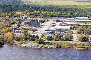
The Attawapiskat First Nation is an isolated First Nation located in Kenora District in northern Ontario, Canada, at the mouth of the Attawapiskat River on James Bay. The traditional territory of the Attawapiskat First Nation extends beyond their reserve up the coast to Hudson Bay and hundreds of kilometres inland along river tributaries. The community is connected to other towns along the shore of James Bay by the seasonal ice road/winter road constructed each December, linking it to the towns of Kashechewan First Nation, Fort Albany, and Moosonee Attawapiskat, Fort Albany, and Kashechewan operate and manage the James Bay Winter Road through the jointly owned Kimesskanemenow Corporation, named after the Cree word for "our road" -kimesskanemenow. Attawapiskat is the most remote northerly link on the 310 km (190 mi) road to Moosonee. They control the reserves at Attawapiskat 91 and Attawapiskat 91A.
The Waywayseecappo First Nation is a First Nations band government whose reserve is located twenty miles east of Russell, Manitoba, Canada. The First Nation's reserve is 10,059 hectare and is located near the southwestern corner of the Riding Mountain National Park. It is bordered by the Rural Municipality of Rossburn and the Rural Municipality of Silver Creek. The First Nation also hold interest together with 32 other First Nations on the 37.1 hectare Treaty Four Reserve Grounds , located adjacent to Fort Qu'Appelle. Its population was 1,219 in 2011. They are home of the MJHL team Waywayseecappo Wolverines. There are several businesses located in the Birdtail valley near PTH 45, such as a gas station, food mart, gaming centre, health centre, daycare, and community arena complex. As of April 1, 2014, the RCMP is no longer in the community, being replaced by the Manitoba First Nations Police Service.
Attawapiskat Airport is an airport adjacent to the Attawapiskat First Nation in Ontario, Canada.

Division No. 17 is a census division in Alberta, Canada. It spans the central and northwest portions of northern Alberta and its largest urban community is the Town of Slave Lake. Division No. 17 is the largest census division in Alberta according to area and also has the lowest population density.
Attawapiskat may refer to:

The Hudson Bay Lowlands is a vast wetland located between the Canadian Shield and southern shores of Hudson Bay and James Bay. Most of the area lies within the province of Ontario, with smaller portions reaching into Manitoba and Quebec. Many wide and slow-moving rivers flow through this area toward the saltwater of Hudson Bay: these include the Churchill, Nelson and Hayes in Manitoba, Severn, Fawn, Winisk, Asheweig, Ekwan, Attawapiskat, and Albany in Ontario, and the Harricana, Rupert and Eastmain in Quebec. This is the largest wetland in Canada, and one of the largest in the world. The region can be subdivided into three bands running roughly northwest to southeast: the Coastal Hudson Bay Lowland, Hudson Bay Lowland, and James Bay Lowland.
The Victor Mine was the first Canadian diamond mine located in Ontario, and De Beers' second diamond mine in Canada. It is located in the Northern Ontario Ring of Fire, in the James Bay Lowlands 90 kilometres (56 mi) west of Attawapiskat in the remote northern part of the province. In June 2005, the Attawapiskat First Nation voted in favour (85.5%) of ratifying the Impact Benefit Agreement (IBA). Construction of the mine began in February 2006 which created 3200 positions; mining and operations will create around 400 permanent positions. The Victor Mine is an open-pit mine, with a processing plant, workshops, and an airstrip located on site. By 2013–2014 royalties collected from De Beers Victor Mine amounted to $226. At that time De Beers was continuing to pay off its "$1 billion investment to build the mine and from now until it closes, the company expects to pay tens of millions of dollars in royalties." The mine completed mining and processing in 2019 and has moved to a shut-down phase including demolition of infrastructure and rehabilitation of the site.
Quinton is a village in the Canadian province of Saskatchewan within the Rural Municipality of Mount Hope No. 279 and Census Division No. 10. The village is located on Highway 15 between the Town of Raymore and the Village of Punnichy. It is near the administrative office of the Kawacatoose First Nations.

Shannen's Dream is a Canadian youth-driven movement advocating for equitable education funding for First Nations children. Education on-reserve is funded by the Government of Canada, while off-reserve education is funded by provincial or territorial governments. Several reports by the Auditor General of Canada, the Parliamentary Budget Officer, and other authorities have indicated an urgent need for improved funding for on-reserve education. Shannen's Dream advocates for the building of safe and comfy schools on reserves, and culturally based education for all First Nations children and youth. The movement was named in honour of Shannen Koostachin, a young activist from the Attawapiskat First Nation and a nominee for the 2008 International Children's Peace Prize
Theresa Spence is a former chief of the Attawapiskat First Nation in Canada. She was a prominent figure in the Attawapiskat housing and infrastructure crisis, Idle No More, and other First Nations issues. Prior to serving as chief, she was the deputy chief of Attawapiskat.
The People of the Kattawapiskak River is a 2012 documentary film by Alanis Obomsawin exploring conditions inside the Attawapiskat First Nation, which in October 2011 declared a state of emergency due to health and safety concerns over a lack of housing and infrastructure, and remained in the public spotlight during the Idle No More protests.
Hi-Ho Mistahey! is a 2013 National Film Board of Canada feature documentary film by Alanis Obomsawin that profiles Shannen's Dream, an activist campaign first launched by Shannen Koostachin, a Cree teenager from Attawapiskat, to lobby for improved educational opportunities for First Nations youth.
Attawapiskat 91 is a First Nations reserve in Kenora District, northwestern Ontario. It was the main reserve of the Attawapiskat First Nation, but most have moved to the new reserve at Attawapiskat 91A.
Midnight Shine is a Canadian roots-rock band from Northern Ontario and Manitoba, consisting of lead vocalist/guitarist Adrian Sutherland, bassist/vocalist Stan Louttit, guitarist/vocalist Zach Tomatuk and drummer Charnelle Menow. They have released three studio albums and three music videos and have been actively touring across Canada since 2016.


