
The English River is a river in Kenora District and Thunder Bay District in Northwestern Ontario, Canada. It flows through Lac Seul to join the Winnipeg River at Tetu Lake as a right tributary. The river is in the Hudson Bay drainage basin, is 615 kilometres (382 mi) long and has a drainage basin of 52,300 square kilometres (20,200 sq mi). There are several hydroelectric plants on this river.

The Kenogami River is a river in the James Bay drainage basin in Thunder Bay and Cochrane districts in Northern Ontario, Canada, which flows north from Long Lake near Longlac to empty into the Albany River. The river is 320 kilometres (199 mi) in length and its name means "long water" in the Cree language. A portion of the river's headwaters have been diverted into the Lake Superior drainage basin.

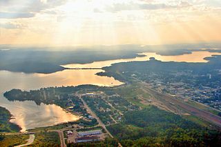
Sioux Lookout is a town in Northwestern Ontario, Canada. Located approximately 350 km (220 mi) northwest of Thunder Bay, it has a population of 5,272 people, an elevation of 390 m, and its boundaries cover an area of 536 km², of which 157 is lake and wetlands. Known locally as the "Hub of the North", it is serviced by the Sioux Lookout Airport, Highway 72, and the Sioux Lookout railway station. According to a 2011 study commissioned by the municipality, health care and social services ranked as the largest sources of employment, followed by the retail trade, public administration, transportation and warehousing, manufacturing, accommodation and food services, and education.

Alcona is a railway point and settlement in the town of Sioux Lookout, Kenora District in northwestern Ontario, Canada.

Minaki is an unincorporated area and community in Unorganized Kenora District in northwestern Ontario, Canada. It is located at the point where the Canadian National Railways transcontinental main line crosses the Winnipeg River, between Wade to the west and Ena Lake at the east, and was accessible only by rail until about 1960. It was a fuelling and watering point in the days of steam locomotives; now few trains stop in Minaki, though the thrice-weekly Via Rail transcontinental Canadian passenger trains will stop on request at the Minaki railway station.
Savant Lake is an unincorporated place and community in Unorganized Thunder Bay District in northwestern Ontario, Canada.
King's Highway 72, commonly referred to as Highway 72, is a provincially maintained highway in the northern half of the Canadian province of Ontario. The highway connects Highway 17 in Dinorwic with the town of Sioux Lookout, where there are connections with Highway 516 towards Savant Lake and Highway 642 towards Silver Dollar.

Marchington Lake is a lake in the Hudson Bay drainage basin located near Sioux Lookout in the Kenora District of northwestern Ontario, Canada.

Hudson is an unincorporated place and community in the municipality of Sioux Lookout, Kenora District in northwestern Ontario, Canada. It is located on Lost Lake on the English River in the Nelson River drainage basin.

Sioux Lookout railway station is located in the town of Sioux Lookout, Kenora District in northwestern Ontario, Canada. The station is on the Canadian National Railway transcontinental main line; it is used by Via Rail and served by transcontinental Canadian trains.
Flindt Landing is an unincorporated place and railway point in Unorganized Thunder Bay District in northwestern Ontario, Canada.
Pelican Lake is a lake in the Hudson Bay drainage basin in the town of Sioux Lookout and in Unorganized Kenora District in Kenora District, northwestern Ontario, Canada. It is about 8.5 kilometres (5.3 mi) long and 6.3 kilometres (3.9 mi) wide and lies at an elevation of 356 metres (1,168 ft). The town centre of Sioux Lookout is on the east shore of the lake, the railway point Pelican on the southwest, and the Canadian National Railway transcontinental main line crosses the lake and runs along the west shore.
Summit Lake is a lake in the James Bay drainage basin in the Unorganized North Part of Algoma District in northeastern Ontario, Canada. It is the source of the Kabinakagami River, which flows via the Kenogami River and Albany River to James Bay. The lake is about 1.0 kilometre (0.6 mi) long and 0.2 kilometres (0.1 mi) wide, lies at an elevation of 442 metres (1,450 ft), and there are no significant inflows.
Summit Lake is a lake in geographic Shenango Township in the Unorganized North Part of Sudbury District in Northeastern Ontario, Canada. It is in the James Bay drainage basin about 29 kilometres (18 mi) northwest of the community of Foleyet on Highway 101, and 4 kilometres (2.5 mi) northwest of the Missonga and 6.7 kilometres (4.2 mi) southeast of the Oatland railway points on the Canadian National Railway transcontinental main line, which runs along the entire west side of the lake.
Superior Junction is a community in the town of Sioux Lookout, Kenora District in northwestern Ontario, Canada. It is on the Marchington River downstream of Botsford Lake and upstream of the river's mouth at Abram Lake on the English River.
Staunton is an unincorporated place and railway point in Unorganized Thunder Bay District in northwestern Ontario, Canada.

The Kapuskasing River is a river in the James Bay drainage basin in Cochrane District and Algoma District in northeastern Ontario, Canada. The river is a left tributary of the Mattagami River.
Elsas is an unincorporated place and railway point in geographic Kapuskasing Township, in the Unorganized North part of Algoma District in northeastern Ontario, Canada. It is on the Canadian National Railway transcontinental railway main line between the railway points of Agate to the west and Oatland to the east, and is the location of Elsas railway station, a stop for Via Rail transcontinental Canadian trains. The station and settlement are on the northern shore of Kapuskasing Lake, the source of the Kapuskasing River.
Kapuskasing Lake is a lake in Algoma District and Sudbury District in northeastern Ontario, Canada. It is in the James Bay drainage basin and is the source of the Kapuskasing River. The majority of the lake is in geographic Kapuskasing Township, Algoma District, with just the southern tip in geographic Sherlock Township, Sudbury District.

