Kenora District

Last updated

Kenora District
Map of Ontario KENORA.svg
Location of Kenora District in Ontario
Coordinates: 49°46′N94°29′W / 49.767°N 94.483°W / 49.767; -94.483
CountryFlag of Canada (Pantone).svg  Canada
Province Flag of Ontario.svg  Ontario
Region Northwestern Ontario
Created1907
Government
   MPs Eric Melillo (CPC), Charlie Angus (NDP)
   MPPs Greg Rickford (PC), Guy Bourgouin (NDP), Sol Mamakwa (NDP)
Area
[1]
  Land407,213.01 km2 (157,225.82 sq mi)
Highest elevation
505 m (1,657 ft)
Lowest elevation
0 m (0 ft)
Population
 (2016) [2]
  Total65,533
  Density0.16/km2 (0.4/sq mi)
Time zones
West of 90° west/Kitchenuhmaykoosib Inninuwug First Nation UTC-6 (Central (CST))
  Summer (DST) UTC-5 (Central Daylight (CDT))
East of 90° west UTC-5 (Eastern (EST))
  Summer (DST) UTC-4 (Eastern Daylight (EDT))
Pickle Lake/Mishkeegogamang First Nation UTC-5 (Eastern (EST))
Postal Code FSA
Area code 807
Largest communities [3] Kenora (15,177)
Dryden (8,195)
Sioux Lookout (5,183)

Kenora District is a district and census division in Northwestern Ontario, Canada. The district seat is the City of Kenora.

Contents

It is geographically the largest division in Ontario: at 407,213.01 square kilometres (157,225.82 sq mi), it covers 38 percent of the province's area, making it larger than Newfoundland and Labrador, and slightly smaller than Sweden or roughly the land size of California. Kenora District also has the lowest population density of any of Ontario's census divisions (it ranks 37th out of 50 by total population).

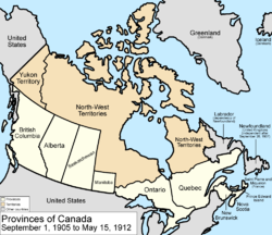
The district was created in 1907 from parts of Rainy River District. The northern part (north of the Albany River) only became part of Ontario in 1912 (transferred from the Northwest Territories). [4] The separate Patricia District upon transfer, it was in 1937 annexed to Kenora District and known sometimes as the Patricia Portion. [5]

Politics

As with the other districts of Northern Ontario, the Kenora District does not have an organized government like those of counties or regional municipalities in Southern Ontario. All government services in the district are instead provided by the local municipalities, by local services boards in some unincorporated communities, or directly by the provincial government.

Geography

The climate is very harsh because of the influence of the cold waters of Hudson and James Bays: most of the region is taiga characterized by discontinuous permafrost, but on the extreme northern coast there are – remarkably for a latitude of only 54°N – patches of true Arctic tundra and continuous permafrost. This is the southernmost point in the Northern Hemisphere reached by the circumpolar line of continuous permafrost on any continent.

Kenora District is geographically extensive enough to share borders with both the contiguous United States (the boundary between it and the Northwest Angle is located in the Lake of the Woods) and the Canadian Arctic waters (Hudson Bay), the only district in Canada to do so.

The District contains the Sturgeon Lake Caldera, which is one of the world's best preserved Neoarchean caldera complexes and is some 2.7 billion years old. [6]

Subdivisions

Cities

CityPopulationRef.
Dryden 7,749
Kenora 15,096
Red Lake, Ontario Red Lake ON 1.JPG
Red Lake, Ontario

Towns

TownPopulationRef.
Red Lake 4,107
Sioux Lookout 5,272

Townships

TownshipPopulationRef.
Ear Falls 1,026
Ignace 1,202
Machin 935
Pickle Lake 425
Sioux Narrows-Nestor Falls 567

First Nations reserves

ReservePopulationRef.ReservePopulationRef.
Attawapiskat 1,549 Northwest Angle 33 187
Bearskin Lake 461 North Spirit Lake 263
Cat Lake 489 Pikangikum 2,100
Deer Lake 763 Poplar Hill 473
Eabametoong 1,014 Rat Portage 38A 362
Eagle Lake 27 227 Sabaskong Bay 35D 387
English River 21 639 Sachigo Lake 443
Fort Albany 67 (part)2,031 Sandy Lake 1,861
Fort Severn 89 361 Shoal Lake 39A (part)388
Islington 29 832 Shoal Lake 40 (part)101
Kasabonika 681 Shoal Lake 34B2 97
Keewaywin 340 The Dalles 38C 195
Kenora 38B 394 Wabauskang 21 75
Kingfisher Lake 462 Wabigoon Lake 184
Kitchenuhmaykoosib Inninuwug 904 Wapekeka 355
Lac Seul 872 Wawakapewin 21
Lake of the Woods 31G N/A Weagamow Lake 87 677
Lake of the Woods 37 46 Whitefish Bay 32A 670
Marten Falls 190 Whitefish Bay 33A 79
Mishkeegogamang 1,920 Whitefish Bay 34A 126
Muskrat Dam Lake 281 Wunnumin Lake 565
Neskantaga 265

Unorganized areas

Demographics

As a census division in the 2021 Census of Population conducted by Statistics Canada, the Kenora District had a population of 66,000 living in 24,818 of its 32,914 total private dwellings, a change of 0.7% from its 2016 population of 65,533. With a land area of 395,432.07 km2 (152,677.18 sq mi), it had a population density of 0.2/km2 (0.4/sq mi) in 2021. [7]

Canada census – Kenora community profile
2021 2016 2011
Population66,000 (+0.7% from 2016)65,533 (13.8% from 2011)57,607 (−10.6% from 2006)
Land area395,432.07 km2 (152,677.18 sq mi)407,213.01 km2 (157,225.82 sq mi)
Population density0.2/km2 (0.52/sq mi)0.1/km2 (0.26/sq mi)
Median age37.6 (M: 36.8, F: 38.4)
Private dwellings32,914 (total)  24,818 (occupied)31,191 (total) 29,606 (total) 
Median household income$78,500
Notes: Excludes census data for one or more incompletely enumerated Indian reserves.
References: 2021 [8] 2016 [2] 2011 [1] earlier [9] [10]
Historical population figures
200620011996
Population64,41961,80263,360
References [10]

Economy

Most of the population is concentrated in the district's extreme south where some agriculture is possible: the main crop is barley. Traditional native activities such as hunting and fishing dominate the north of the district outside of mining settlements.

Mining

The area near Lake Minnehaha saw a gold rush between 1902 and 1909. The settlement of Gold Rock served 14 area mines, which included the Big Master, Laurentian, Detola and Elora. According to Barnes, "Approximately 180,000 ounces of gold was won from 27 mines in the Kenora district from 1880 to 1976," with "over 331 known gold occurrences." The more successful mines included the Bully Boy, Cameron Island, Champion, Combined, Cornucopia, Gold Hill, Golden Horn, Kenricia, Mikado, Oliver, Olympia, Ophyr, Regina, Scramble, Severn, Stella, Sultana, Treasure and Wendigo. [11]

Mining is currently extremely extensive in northern Kenora District, which contains some of the world's largest and highest-grade reserves of uranium and some of the world's major producers of nickel. A major mining exploration project is currently underway in the Ring of Fire region, centred on the district's isolated McFaulds Lake.

Transportation

Highway 599, longest secondary highway in Ontario Hwy 599 ON.JPG
Highway 599, longest secondary highway in Ontario

Permanent roads (Highway 599) only reach about halfway to the northernmost point of Kenora district, with the provincial highway network ending at Pickle Lake. Some more northerly communities connect seasonally through an ice/winter road network to the Northern Ontario Resource Trail.

Year-round air and summertime river transport are the only means of reaching the most remote parts of the district.

The major railroad lines between Toronto and British Columbia pass through the south of the district. The district is served by Via Rail's Canadian at Rice Lake, [12] Copelands Landing, [13] Malachi, Ottermere, Minaki, Redditt, Farlane station, Canyon, Red Lake Road, Richan, and Sioux Lookout stations.

Current services at Copelands Landing
Preceding station VIA Rail Canada simplified.svg Via Rail Following station
Rice Lake
toward Vancouver
The Canadian Malachi
toward Toronto
Former services at Copelands Landing
Preceding station Canadian National Railway Following station
Rice Lake
toward Vancouver
Main Line Malachi
toward Montreal

Patricia Portion

Provincial boundaries of Canada prior to 1912. The portion of Ontario's modern boundaries which is not represented as part of Ontario in this map constitutes the "Patricia Portion" of Kenora District. Canada provinces 1905-1912.png
Provincial boundaries of Canada prior to 1912. The portion of Ontario's modern boundaries which is not represented as part of Ontario in this map constitutes the "Patricia Portion" of Kenora District.

The Patricia Portion is the part of the Kenora District lying north of the Albany River, which was transferred from the Northwest Territories to Ontario on May 15, 1912, in The Ontario Boundaries Extension Act. [4] This area was originally a separate division, Patricia District, but became part of Kenora District in 1937. [5]

With the exception of a few communities along the northernmost ends of Highway 599 and the Highway 105/Highway 125 corridor, the Patricia Portion consists almost entirely of remote First Nations communities that are only accessible by float plane or winter road. Accordingly, the term "Patricia Portion" is still sometimes used to distinguish the region from the relatively more populated and road-accessible southern portion.

See also

Related Research Articles

<span class="mw-page-title-main">Dryden, Ontario</span> City in Ontario, Canada

Dryden is the second-largest city in the Kenora District of Northwestern Ontario, Canada, located on Wabigoon Lake. It is the least populous community in Ontario incorporated as a city. The City of Dryden had a population of 7,749 and its population centre had a population of 5,586 in 2016.

<span class="mw-page-title-main">Kenora</span> City in Ontario, Canada

Kenora, previously named Rat Portage, is a city situated on the Lake of the Woods in Ontario, Canada, close to the Manitoba boundary, and about 210 km (130 mi) east of Winnipeg by road. It is the seat of Kenora District.

<span class="mw-page-title-main">Northern Ontario</span> Primary Region in Ontario, Canada

Northern Ontario is a primary geographic and quasi-administrative region of the Canadian province of Ontario, the other primary region being Southern Ontario. Most of the core geographic region is located on part of the Superior Geological Province of the Canadian Shield, a vast rocky plateau located mainly north of Lake Huron, the French River, Lake Nipissing, and the Mattawa River. The statistical region extends south of the Mattawa River to include all of the District of Nipissing. The southern section of this district lies on part of the Grenville Geological Province of the Shield which occupies the transitional area between Northern and Southern Ontario. The extended federal and provincial quasi-administrative regions of Northern Ontario have their own boundaries even further south in the transitional area that vary according to their respective government policies and requirements. Ontario government departments and agencies such as the Growth Plan for Northern Ontario and the Northern Ontario Heritage Fund Corporation define Northern Ontario as all areas north of, and including, the districts of Parry Sound and Nipissing for political purposes, and the federal but not the provincial government also includes the district of Muskoka.

<span class="mw-page-title-main">Wawa, Ontario</span> Municipality in Ontario, Canada

Wawa is a township in the Canadian province of Ontario in the Algoma District. Formerly known as the Township of Michipicoten, named after a nearby river of that name, the township was officially renamed in 2007 for its largest and best-known community of Wawa, located on the western shores of Wawa Lake.

<span class="mw-page-title-main">Marathon, Ontario</span> Town in Ontario, Canada

Marathon is a town in the Canadian province of Ontario, located in Thunder Bay District, on the north shore of Lake Superior north of Pukaskwa National Park.

<span class="mw-page-title-main">Pickle Lake</span> Township in Ontario, Canada

Pickle Lake is a township in the Canadian province of Ontario, and is the most northerly community in the province that has year-round access by road. Located 530 kilometres (330 mi) north of Thunder Bay, highway access is via Highway 599, the only access road to the town from the south. More northerly communities rely on winter roads for access and are cut off to land travel in the summer. Highway 599 meets the Northern Ontario Resource Trail, formerly Tertiary Highway 808, at Pickle Lake.

<span class="mw-page-title-main">Unorganized Kenora District</span> Unorganized area in Ontario, Canada

Unorganized Kenora District is an unorganized area in northwestern Ontario, Canada, in Kenora District. Constituting 98.39 percent of the district's land area, yet only 10.93 percent of its population, it is essentially the remainder of the district's territory after all incorporated cities, municipalities, townships, Indian reserves, and Indian settlements have been excluded. It is by far the largest municipal-equivalent level census division in Ontario, covering over 35 percent of the entire provincial land area, yet only about 0.05 percent of the population of Ontario.

<span class="mw-page-title-main">Unorganized Thunder Bay District</span> Unorganized area in Ontario, Canada

Unorganized Thunder Bay District is an unorganized area in northwestern Ontario, Canada in Thunder Bay District. It comprises all parts of the district that are not part of an incorporated municipality or a First Nations reserve.

<span class="mw-page-title-main">Unorganized North Algoma District</span> Unorganized area in Ontario, Canada

Unorganized North Algoma District is an unorganized area in northeastern Ontario, Canada, comprising all areas in Algoma District, north of the Sault Ste. Marie to Elliot Lake corridor, which are not part of an incorporated municipality or a First Nation. It covers 44,077.03 km2 (17,018.24 sq mi) of land, and had a population of 6050 in 2021. Many of these communities were/are stations on the Algoma Central Railway or were logging/mining towns.

<span class="mw-page-title-main">Minaki</span> Place in Ontario, Canada

Minaki is an unincorporated area and community in Unorganized Kenora District in northwestern Ontario, Canada. It is located at the point where the Canadian National Railways transcontinental main line crosses the Winnipeg River, between Wade to the west and Ena Lake at the east, and was accessible only by rail until about 1960. It was a fuelling and watering point in the days of steam locomotives; now few trains stop in Minaki, though the thrice-weekly Via Rail transcontinental Canadian passenger trains will stop on request at the Minaki railway station.

<span class="mw-page-title-main">Hornepayne</span> Township in Ontario, Canada

Hornepayne is a township of 980 people in the Algoma District of Ontario, Canada. The town was established in 1915 as Fitzback when the Canadian Northern Railway's transcontinental line was built through the area. It was renamed Hornepayne in 1920 after British financier Robert Horne-Payne. The municipality was originally named Wicksteed Township after the geographic township in which it is located. It was renamed Hornepayne, after its primary community, in 1986.

<span class="mw-page-title-main">Red Lake, Ontario</span> Municipality in Ontario, Canada

Red Lake is a municipality with town status in the Canadian province of Ontario, located 535 km (332 mi) northwest of Thunder Bay and less than 100 km (62 mi) from the Manitoba border. The municipality consists of six small communities—Balmertown, Cochenour, Madsen, McKenzie Island, Red Lake and Starratt-Olsen—and had a population of 4,107 people in the Canada 2016 Census.

<span class="mw-page-title-main">Alberton, Ontario</span> Township in Ontario, Canada

The Township of Alberton is a community in the Rainy River District of Northwestern Ontario, Canada. It is made up of the two geographic townships Crozier and Roddick. The township borders Fort Frances to the east, La Vallee to the west, the unincorporated geographical township of Miscampbell to the north, and the city of International Falls to the south.

<span class="mw-page-title-main">Ear Falls</span> Township in Ontario, Canada

Ear Falls is a township located in Northwestern Ontario, Canada, on the banks of the English River, Lac Seul, Pakwash Lake and Wenesaga Lake. It is located along Highway 105, 100 kilometres (62 mi) north of Highway 17 and Vermilion Bay, about halfway between Highway 17 and Red Lake, or about 480 kilometres (300 mi) northwest of Thunder Bay.

<span class="mw-page-title-main">Matachewan</span> Township in Ontario, Canada

Matachewan is a township in Timiskaming, Northeastern Ontario, Canada, located at the end of Ontario Highway 66 along the Montreal River. The name is derived from the Cree word for "meeting of the currents".

<span class="mw-page-title-main">Sioux Narrows-Nestor Falls</span> Township in Ontario, Canada

Sioux Narrows-Nestor Falls is a township in the Canadian province of Ontario, located in the Kenora District. It is located on the eastern shores of Lake of the Woods along Ontario Highway 71.

Redditt is an unincorporated community in Unorganized Kenora District in northwestern Ontario, Canada. It is on the MacFarlane River, and located at the northern terminus of Ontario Highway 658, 27 kilometres (17 mi) north of Kenora. Redditt is also the name of the surrounding geographic township that includes the community.

<span class="mw-page-title-main">Ontario Highway 658</span> Ontario provincial highway

Secondary Highway 658, commonly referred to as Highway 658, is a provincially maintained highway in the Canadian province of Ontario, located in Kenora District. The highway extends 25.3 kilometres (15.7 mi) between the city of Kenora and the community of Redditt. For a decade, Highway 658 was numbered as Highway 666, leading to numerous sign thefts and a petition by members of a church on the route. This petition eventually led to the route being renumbered in late 1985.

Ena Lake is the name of a lake and an adjacent unincorporated area and railway point in Unorganized Kenora District in northwestern Ontario, Canada, about 23 kilometres (14 mi) north of the city of Kenora. Formerly a stop on the Canadian National Railway, it is now a small cottage community of approximately 50 seasonal residents and 11 year round residents.

References

  1. 1 2 "2011 Community Profiles". 2011 Canadian Census . Statistics Canada. March 21, 2019. Retrieved March 20, 2012.
  2. 1 2 "2016 Community Profiles". 2016 Canadian Census . Statistics Canada. August 12, 2021.
  3. Compilation of Northwestern Ontario's 2006 census data
  4. 1 2 The Ontario Boundaries Extension Act, S.C. 1912 (CA), 2 Geo. V, c. 40.
  5. 1 2 Patricia Act, RSO 1937, c 5 (retrieved March 26, 2016).
  6. Caldera Volcanoes Retrieved on July 20, 2007
  7. "Population and dwelling counts: Canada and census divisions". Statistics Canada. February 9, 2022. Retrieved April 2, 2022.
  8. "2021 Community Profiles". 2021 Canadian Census . Statistics Canada. February 4, 2022. Retrieved October 19, 2023.
  9. "2006 Community Profiles". 2006 Canadian Census . Statistics Canada. August 20, 2019.
  10. 1 2 "2001 Community Profiles". 2001 Canadian Census . Statistics Canada. July 18, 2021.
  11. Barnes, Michael (1995). Gold in Ontario. Erin: The Boston Mills Press. pp. 23–26. ISBN   155046146X.
  12. "Rice Lake train station | VIA Rail". Via Rail . Retrieved March 29, 2024.
  13. "Copelands Landing train station | VIA Rail". www.viarail.ca. Via Rail . Retrieved March 29, 2024.