The Regional Municipality of York, also called York Region, is a regional municipality in Southern Ontario, Canada, between Lake Simcoe and Toronto. The region was established after the passing of then Bill 102, An Act to Establish The Regional Municipality of York, in 1970. It replaced the former York County in 1971, and is part of the Greater Toronto Area and the inner ring of the Golden Horseshoe. The regional government is headquartered in Newmarket.
As of the 2021 census, York Region's population was 1,173,334, with a growth rate of 5.7% from 2016.[1] The Government of Ontario expects its population to surpass 1.5 million residents by 2031.[2] The three largest cities in York Region are Markham, Vaughan and Richmond Hill.[3]
History
At a meeting in Richmond Hill on May 6, 1970, officials representing the municipalities of York County approved plans for the creation of a regional government entity to replace York County.[4] The plan had been presented in 1969 by Darcy McKeough, the Ontario Minister of Municipal Affairs, taking about a year to determine municipal boundaries within the new regional government.[4]
The Regional Municipality of York was created by Act of the Legislative Assembly of Ontario in 1970 (Bill 102 An Act to Establish The Regional Municipality of York), which took effect on January 1, 1971.[5] The creation of the regional municipality resulted in the consolidation of the fourteen former municipalities of York County into nine new municipalities:[6]
Creation of municipalities in the Regional Municipality of York (1971)[7]
Village of Stouffville, annexing portions of the Townships of Markham (four lots south of Main Street) and Whitchurch
The township of Whitchurch merged with the town of Stouffville to create the town of Whitchurch–Stouffville, ceding land to Aurora, Newmarket, and Richmond Hill to the west of the proposed Highway 404 and annexing a northern strip of land from the township of Markham.[8] The western boundary of the new town of Markham was defined to be at Yonge Street, where its northern boundary was formed with Richmond Hill (to which it ceded land[4]) and its western boundary with the new town Vaughan.[8] The new town of Vaughan would consist of all communities in the area bounded by Markham and Richmond Hill in the east, Metro Toronto in the south, the periphery of the regional municipality in the west, and the new township of King in the north.[8]
The townships of Georgina, North Gwillimbury, and Sutton were merged into the township of Georgina, and the East Gwillimbury neighbourhood of East Gwillimbury Heights was merged into Newmarket.[8] King formed the northwestern part of the new region, but the eastern lot from Bathurst Street to Yonge Street was ceded to Newmarket, Aurora, and Oak Ridges, the last of which became a part of Richmond Hill.[8] The boundary between Aurora and Newmarket was defined to be St. John's Sideroad, and Newmarket's northern boundary was defined to be Green Lane.[8]
The towns of Aurora, Newmarket, and Richmond Hill were defined to be the growth centres for the regional municipality, which was to become a greenbelt between the denser urban areas of Toronto to the south and Barrie to the north.[6] The growth centres were each restricted to grow to a maximum population of 25,000 by 2000,[6] and the regional municipality to 300,000.[8]
The municipal realignment merged 40% of East Gwillimbury's population into Newmarket.[9] The council of East Gwillimbury voted to amalgamate with Newmarket, but Newmarket council opposed the amalgamation.[9] In the plan presented by McKeough, the councils of the towns of Newmarket and Aurora were given ten years to decide whether or not to amalgamate.[6]
The internal municipal realignments resulted in some politicians residing in a new municipality from that which they represented at the time of realignment.[4] The reeve of Whitchurch Township resided in the western portion of the town that was annexed by Aurora, three East Gwillimbury councillors resided in land annexed by Newmarket, including its future mayor Ray Twinney, and King councillor Gordon Rowe was a resident of Oak Ridges, which became part of Richmond Hill.[4]
Hydro Commissions
Because of the mix of urban and rural areas in the Region, the provision of electricity was governed in a different manner from the rest of the regional services:[10]
the hydro-electric commissions and public utilities commissions that existed at the end of 1970 continued to provide electricity within their respective areas;
the councillors of the former Township of Vaughan and the trustees of the former Police Village of King City became members of new Hydro-Electric Commissions for their respective areas;
Ontario Hydro continued to have responsibility for providing electricity to those portions of the Region that were not served by any of the above commissions.
Electric distribution was partially rationalized in 1978,[11] when:
hydro-electric commissions were established for all area municipalities except East Gwillimbury[12] (but it could establish a commission later on, subject to Ontario Hydro's consent);[13]
effective January 1, 1979, all assets of the former commissions in the Region were transferred to the new commissions;[14]
Ontario Hydro withdrew its provision of services from all areas except those in East Gwillimbury, Georgina, King and Whitchurch-Stouffville;[14]
Georgina, King and Whitchurch-Stouffville could take over responsibility for such areas at a later date, subject to Ontario Hydro's consent[14]
York Region covers 1,762 square kilometres from Lake Simcoe in the north to the city of Toronto in the south. Its eastern border is shared with Durham Region, to the west is Peel Region, and Simcoe County is to the northwest. A detailed map of the region[16] showing its major roads, communities and points of interest is available.
York Region's landscape includes farmlands, wetlands and kettle lakes, the Oak Ridges Moraine and over 2,070 hectares of regional forest, in addition to the built-up areas of its municipalities. The highest point in the region is within the rolling hills of the moraine near Dufferin St. & Aurora Side Road at 360m ASL (1,243 feet)[17]
Climate
York Region is situated in the humid continental climate (Köppen Dfb) zone with warm summers and cold winters, ample snowfall, more in the northern part of York region much of it derived from the wind driven snowbelt streamer activity.
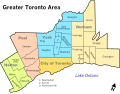
York Region Richmond Hill Office at Yonge & Hwy 7Map of York Region and the municipalities it includes.
The region is governed by York Regional Council, which consists of 20 elected representatives from each of the constituent towns and cities in the region. These include each of the nine mayors, and 11 regional councillors who are elected from the constituent municipalities as follows:[24]
1 from Georgina
1 from Newmarket
2 from Richmond Hill
3 from Vaughan
4 from Markham
The regional councilors are elected at-large for each lower-tier municipality which has them. They are also voting members of their respective city/town council.
The leader of Council is referred to as "Regional Chair and CEO". Wayne Emmerson, a former mayor of Whitchurch-Stouffville, was elected to this office in December 2014[25] and served until retiring in 2024.[26] Eric Jolliffe was appointed as the new Chair shortly afterwards and took office on January 1, 2025.[26]
Provincially, York Region is represented in the Legislative Assembly of Ontario by Members of Provincial Parliament. As of 2018, the provincial electoral districts are the same as the federal districts in most of Ontario.
Proposed reformations
In May 2023, Premier Doug Ford announced that he would look to dissolve and restructure existing regional municipalities where deemed prudent. In response, Markham mayor Frank Scarpitti publicly proposed amalgamating York Region into a single-tier municipality, claiming it would save millions of dollars.[28] The idea was met with immediate disapproval from all other York Region mayors, excluding Vaughan Mayor Steven Del Duca, who had not publicly expressed an opinion at the time. Scarpitti was criticized for not consulting with the other mayors about his proposal before publicly announcing it, which the others mayors saw as dramatic.[29] Ford later announced that he had no interest in Scarpitti's proposal to amalgamate, and that any future proposals which were to be seriously considered must be deliberated among all of the other mayors in a region before being made public.[30]
Later, Vaughan mayor Steven Del Duca proposed dissolving York Region and making all of its lower-tier municipalities independent, claiming that Vaughan contributed more tax dollars than it received in regional funding.[31][32] No other politicians endorsed Del Duca's proposal. The mayors and councilors of York Region have generally agreed with looking into potential reforms to streamline government operations.[32][33] However, the mayors of the smaller towns, such as Newmarket and Whitchurch-Stouffville, strongly urged for dialogue and diplomacy, stressing that no municipality should be left behind as a result of a restructuring.[32]
As of January 2025, the Ontario government has not made any indication as to whether York Region will be restructured or remain as-is.
Demographics
As a census division in the 2021 Census of Population conducted by Statistics Canada, the Regional Municipality of York had a population of 1,173,334 living in 391,034 of its 405,863 total private dwellings, a change of 5.7% from its 2016 population of 1,109,909. With a land area of 1,758.27km2 (678.87sqmi), it had a population density of 667.3/km2 (1,728.4/sqmi) in 2021.[1] York is the third-largest census division in Ontario, following Toronto and Peel Region, and seventh-largest in Canada.[34]
In the 2021 Canadian census, English is the mother tongue of 45.5% of the residents of York Region. Cantonese is the mother tongue for 9.7% of the population, followed by Mandarin (8.7%), Italian (4.0%), Farsi (4.4%) and Russian (3.1%).[1]
Ethnicity
As of 2021, the most common ethnic groups are Chinese (22.6%), Italian (12.5%) and English (7.4%).[39]
Note: Totals greater than 100% due to multiple origin responses
Religion
According to the 2021 census, the most reported religion among the population was Christianity (45.3%), with Catholicism (25.2%) making up the largest denomination. This was followed by Islam (7.8%), Judaism (5.2%), Hinduism (5.0%), Buddhism (2.6%) and Sikhism (1.0%). 32.5% of the population did not identify with a particular religion.[39]
Economy
The economy of York Region is diverse. In general, the economy includes a full range of businesses from industrial to high-tech to rural/agricultural. New developments tend to be focused along the Yonge Street corridor from Vaughan/Richmond Hill in the south to Newmarket/Aurora in the north. There are ongoing conflicts between conservationists and developers over land use, with the most contentious being over the use of the Oak Ridges Moraine.
Attractions
York Region has an assortment of points of interest, ranging from nature reserves to pioneer-era museums, to a modern amusement park.
Vaughan's major attractions include the McMichael Canadian Art Collection, in the community of Kleinburg, that features works by Canadian artists including Inuit and First Nations artists. Canada's Wonderland, which features roller coasters and other rides, concerts and fireworks shows, is also in Vaughan.
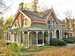
Heritage sites and historical museums in the Region include:
Boomerang Health, in Vaughan, is a centre that provides multidisciplinary rehabilitation and medical services geared specifically for children and adolescents, in collaboration with The Hospital for Sick Children.[50]
Counselling Services for York Region, is a center located in Vaughan that provides mental health services to individuals who are in need of psychological treatment and assessment. Counselling Services for York Region helped lobby for the Ontario Structured Psychotherapy Program which was successfully implemented by Ontario Health. The program was advocated through Advocacy York Region.[51]
The arterial road network in York Region is a grid, with most roads running north–south or east–west. This was done under the leadership of British surveyor Augustus Jones during the 1790s. York Region assigned approximately 50 roads as York Regional Roads, meaning that maintenance of these roads is done by York Region. They are signposted with numbers.
Note: Highway 27 and Highway50 are still referred to as such on municipal road signs, but are no longer provincial highways.
Air transportation
Most air travel is served by Toronto Pearson International Airport, which is outside of York Region and is Canada's largest airport. Markham Airport is a private aerodrome in Markham. There are also a few small airports with unpaved runways serving the region: Hare Field in Holland Landing (East Gwillimbury), Belhaven Airport in Georgina, and Stouffville Aerodrome north of Stouffville.
Buttonville Municipal Airport was a larger regional airport in Markham that was used for general aviation and business aircraft. It closed in November 2023.[52]
GO Transit, which provides commuter bus and rail service
Toronto Transit Commission (TTC), which has several bus routes which cross York's southern border, and which provide service along many north–south arterial streets in Vaughan, Richmond Hill and Markham. The western arm of the TTC's Line 1 Yonge-University extends into Vaughan to serve Vaughan Metropolitan Centre, and a future extension of the Yonge Street (eastern) portion of the line will serve the boundary areas of Vaughan, Richmond Hill, and Markham by the mid-2030's.[53]
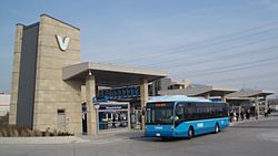
Until 2001, the towns of York Region operated separate public transit services, which did not connect very well with each other. YRT was created by the Regional Government to combine five of these services:
Since 2001, bus routes have been extensively enhanced in the five communities which had pre-existing services, but YRT's services to East Gwillimbury is limited to two routes, and service to King, Georgina and Whitchurch-Stouffville are even more limited due to the relatively small populations in each of those towns.
Water
Water in southern York is provided by Toronto Water and Peel Region by way of 3 pumping stations and reservoirs (Bayview, Dufferin and Milliken (tank and underground reservoir)) using water from Lake Ontario.[54] Keswick and Sutton obtain water from Lake Simcoe by way of water treatment plants. The remainder of York obtains water from a combination of water from Lake Ontario and underground wells. Some wells are maintained by the Region and the rest privately.
Georgina -water from Lake Simcoe and private wells
East Gwillimbury - region and private wells
Newmarket - region wells and water from Lake Ontario[55]
Whitchurch-Stouffville - Region wells, water from Lake Ontario, private wells
Markham - water from Lake Ontario and private wells
Richmond Hill - water from Lake Ontario and private wells
Aurora - water from Lake Ontario and private wells
Vaughan - water from Lake Ontario and private wells
King - water from Lake Ontario, Region and private wells
Water is distributed from 14 water pumping stations and stored at 37 elevated tanks and reservoirs:[citation needed]
List of water tanks
Reesor Park water tank - built 1971, now out of service and dismantled
YRDSB is the largest public school board in the region, operating 175 elementary schools, and 33 secondary schools. YCDSB operates 83 elementary schools, and 15 secondary schools, while MonAvenir operates five elementary schools, and two secondary schools. CSV is the smallest public school board in the York Region, operating three elementary schools, and one secondary school in the region.
Along with public schools, the region also holds a number of religious and private schools including:
In addition to primary and secondary levels of education, the region is also home to post-secondary institutions such as Seneca Polytechnic. The college operates two campuses spread throughout York Region, in King and Markham, as well as additional campuses in Toronto. The region presently does not host a university, but a Markham campus of York University is under construction as of August 2022.[56]
The Region of York signed a "Twinning Agreement" with the city of Omsk, Russia, on August 28, 1997, after it signed a "Friendship Agreement" one year previous.[citation needed]
This page is based on this Wikipedia article Text is available under the CC BY-SA 4.0 license; additional terms may apply. Images, videos and audio are available under their respective licenses.