1974 as a town by amalgamating villages of Cayuga, Hagersville and Caledonia and the townships of Oneida, Seneca, North Cayuga, South Cayuga as well as parts of Rainham and Walpole
Enlarged
2001 by amalgamating with Dunnville and half of Nanticoke
Haldimand's history has been closely associated with that of neighbouring Norfolk County. Upper Canada was created in 1791 by being separated from the old Province of Quebec, Haldimand was created in 1798 as part of the Niagara District.[3] It was named after Sir Frederick Haldimand, the governor of the Province of Quebec from 1778 to 1785. In 1844, the land was surrendered by the Six Nations to the Crown in an agreement that was signed by the vast majority of Chiefs in the Haldimand tract.[citation needed] In 1974, Haldimand was incorporated as a town by the amalgamation of the villages of Cayuga, Hagersville and Caledonia and the townships of Oneida, Seneca, North Cayuga, South Cayuga and parts of Rainham and Walpole. In 2001, Haldimand was enlarged by amalgamating with Dunnville and half of Nanticoke.
Beginning in February 2006, a land dispute by native protesters began near Caledonia over a housing development being built on the outskirts of town, which members of the nearby Mohawk Six Nations people claim is rightfully their land. The issue reignited again in February 2020, when Mohawk protesters blocked off Highway 6 again in protest of McKenzie Meadows.
Smaller communities within the municipality are Attercliffe Station, Balmoral, Bodri Bay, Brookers Bay, Byng, Canborough, Canfield, Cheapside, Clanbrassil, Crescent Bay, Decewsville, Empire Corners, Featherstone Point, Fisherville, Garnet, Hoover Point, Kohler, Little Buffalo, Lowbanks, Moulton Station, Mount Carmel, Mount Healy, Nanticoke, Nelles Corners, Peacock Point, Port Maitland, Rainham Centre, Selkirk, Sims Lock, South Cayuga, Springvale, Stromness, Sweets Corners, Townsend, Willow Grove, Woodlawn Park and York.
The ghost towns of Cook's Station, Cranston, Dufferin, Erie, Indiana, Lambs Corners, Lythmore, Sandusk, Upper, and Varency are also located within Haldimand.
Historic townships
Haldimand County's area of 309,300 acres was formed from part of the land grant to the Six Nations in 1783. The County was purchased by treaty and opened for general settlement in 1832. It was first settled by white veterans of Butler's Rangers established there by Joseph Brant. A large number of Germans were among the first settlers.[4]
Canborough, area 21,586 acres (87km2). Granted in 1794 by Joseph Brant to John Dochstader of Butler's Rangers. Purchased by Benjamin Canby in 1810 for £5,000, he named the village site "Canborough. Community centre: Canborough, Darling and it touches Dunnville
Dunn, area 15,122 acres (61km2). Opened for settlement in 1833. Community centre: Dunnville
Moulton, area 27,781 acres (112km2). Landowner Henry John Boulton named the township from the Boulton family seat in England.
North Cayuga, area 32,825 acres (133km2).
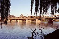
Oneida, area 32,598 acres (132km2). Joseph Brant granted a 999 year lease of part of Oneida and Seneca townships to Henry Nelles, of Butler's Rangers and his sons, Robert, Abraham, William, Warner and John. Community centres were: Caledonia, Dufferin and Hagersville.
Rainham, area 25,705 acres (104km2) Community centres: Balmoral, Selkirk, Rainham Centre and Fisherville.
Seneca, area 41,721 acres (169km2). Community centres: York and Caledonia
Sherbrooke, area 5,098 acres (21km2), the smallest township in Ontario. Opened in 1825 and named from Sir John Coape Sherbrooke, a Governor-General of Canada. The Township was granted by the Indians to William Dickson (a lawyer) as a professional fee. Community centres: Stromness and Port Maitland.
South Cayuga, area 13,293 acres (54km2).
Walpole, area 66,213 acres (268km2). Community centres were: Hagersville, Jarvis, Selkirk, Cheapside and Nanticoke.
In the 2021 Census of Population conducted by Statistics Canada, Haldimand County had a population of 49,216 living in 18,719 of its 20,710 total private dwellings, a change of 7.9% from its 2016 population of 45,608. With a land area of 1,250.45km2 (482.80sqmi), it had a population density of 39.4/km2 (101.9/sqmi) in 2021.[2][9]
Canada census – Haldimand County community profile
Note: Totals greater than 100% due to multiple origin responses
Languages
As of the 2021 census, there were 47,190 citizens that spoke English only, 15 that spoke only French, 1,530 that spoke both official languages and 130 that spoke neither.[2]
Religion
As of the 2021 census, there were 29,380 citizens identifying as Christian and 18,200 as non-religious and secular perspectives.[2][h]
Healthcare in Haldimand County is overseen by Haldimand-Norfolk Health and Social Services.[13] Hospitals in Haldimand County include Haldimand War Memorial Hospital in Dunnville, and West Haldimand General Hospital in Hagersville.
Fire services in the county is provided by the Haldimand County Fire Department which was created in 2001 following the separation of Haldimand and Norfolk. The department currently consists of 11 stations located strategically throughout the county. With almost 300 firefighters and 40 fire apparatuses, it is one of the largest volunteer fire departments in Ontario. The department consists of:
Several intercity bus companies operate routes that travel through Haldimand County, connecting it to nearby cities and towns. Although, driving is the most common way to get around in Haldimand County, as public transportation options are limited.
↑ Middleton, Jesse & Landon, Fred. The province of Ontario, a history, 1615-1927. Toronto, ON: Dominion Publishing.{{cite book}}: CS1 maint: multiple names: authors list (link)
This page is based on this Wikipedia article Text is available under the CC BY-SA 4.0 license; additional terms may apply. Images, videos and audio are available under their respective licenses.