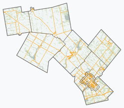
Wellington County | |
---|---|
County of Wellington | |
Motto(s): Vision, Valour | |
Coordinates: 43°45′N80°24′W / 43.750°N 80.400°W | |
Country | Canada |
Province | Ontario |
Established | 1852 |
County seat | Guelph (independent) |
Municipalities | |
Government | |
• Warden | Kelly Linton [1] |
Area | |
• Land | 2,665.36 km2 (1,029.10 sq mi) |
Population (2021) [2] | |
• Total | 241,026 |
• Density | 90.4/km2 (234/sq mi) |
Time zone | UTC-5 (EST) |
• Summer (DST) | UTC-4 (EDT) |
Website | www.wellington.ca/ |
Wellington County is a county located in Southwestern Ontario, Canada and is part of the Greater Golden Horseshoe. The county, made up of two towns and five townships, is predominantly rural in nature. However many of the residents in the southern part of the county commute to urban areas such as Guelph, Kitchener, Waterloo, Brampton, Mississauga, Toronto and Hamilton for employment. The northern part of the county (comprising Minto, Mapleton, and Wellington North townships) is made up of mainly rural farming communities, except for a few larger towns such as Mount Forest and Arthur. According to the 2021 census, the population of the county was 241,026. [2]
In 2018, the Warden of the county was Kelly Linton (mayor of Centre Wellington) and there were 14 Councillors. [1] Police services are provided by the Ontario Provincial Police. [3] Schools are operated by the Upper Grand District School Board and by the Wellington Catholic District School Board.
The county is made up of seven lower-tier municipalities (in order of population):
The City of Guelph, although part of the Wellington census division, is a single-tier city, municipally independent of the county. The primary economy outside of the city consists of agriculture and aggregate mining. [4] The county is a major supplier of sand and gravel for the western part of the Greater Toronto Area. [5]
In 1837, by an Act of the Legislative Assembly of Upper Canada, the District of Wellington was formed and a court house and jail in the town of Guelph were authorized. [6] The District was named after England's Duke of Wellington and its territory formed the County of Waterloo for electoral purposes. [7] The limestone county courthouse and jail in the castellated style was built in 1842-44 and was subsequently expanded. [8]
In 1849, Wellington District was abolished, and Waterloo County remained for municipal and judicial purposes. [9] The territory of the Bruce Peninsula became part of Waterloo in 1849, [10] but was later withdrawn and transferred to Bruce County in 1851. [11]
In January 1852, Waterloo County became the United Counties of Wellington, Waterloo and Grey. [12] The new county of Waterloo was withdrawn in January 1853, and the remainder was renamed the United Counties of Wellington and Grey. [13]
In January 1854, the United Counties was dissolved, and Wellington and Grey were separate counties for all purposes. [14]
Guelph was incorporated as a City in 1879 and withdrawn from the county. [15] Amaranth, East Garafraxa, East Luther and Orangeville were transferred to Dufferin County during the period 1874–1882. [16] [17] [18] [19]
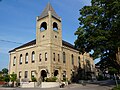
The Wellington County Jail (in Late Gothic Revival Style) and the Governor's Residence (in Georgian style) at 74 Woolwich Street were built in 1911; they were designated by the city for "historic and architectural value" and as a National Historic Site in 1983. The property is now an Ontario Court of Justice. [20]
By 1881, the county had settled into its present form, with the following townships and related towns and villages:
Township | Area | Description | Community centres |
---|---|---|---|
Arthur | 64,494 acres (261 km2) | Opened in 1835, it was named after Arthur Wellesley, 1st Duke of Wellington | Arthur, Kenilworth and Mount Forest |
Eramosa | 44,482 acres (180 km2) | Opened in 1821. The name is an attempt to render in English the Indigenous word "un-ne-mo-sa", which means dog | Eden Mills and Rockwood |
Erin | 70,557 acres (286 km2) | Opened in 1820 | Erin, Hillsburgh, Mimosa |
West Garafraxa | 46,950 acres (190 km2) | Opened in 1821. Name is believed to be from an Indigenous wordword meaning "the place of panthers." | Fergus (only partially in the township), Reading, Metz and Garafraxa |
Guelph Township | 35,543 acres (144 km2) | Opened on April 23, 1827, by John Galt on behalf of the Canada Company | |
West Luther | 49,830 acres (202 km2) | Opened in 1821 and named after the leader of the Reformation in Germany, Martin Luther. It was said that the surveyor, a Roman Catholic, having been embarrassed by the endless swamps he had encountered declared that this was "the meanest piece of country he had seen" and named it Luther for that reason | Monck, Stonywood, Damascus and Arthur |
Maryborough | 56,728 acres (230 km2) | Opened in 1840 and named after a brother of the Duke of Wellington, Baron Maryborough | Drayton, Moorefield and Rothsay |
Minto | 69,927 acres (283 km2) | Opened in 1840 and named after the Earl of Minto, a famous pro-consul in India. Settled mainly between 1861 and 1875 | Harriston, Palmerston, and Clifford |
Nichol | 26,996 acres (109 km2) | One of the townships leased by Joseph Brant under power of attorney for the First Nationss of the Grand River region. The Township was granted to Hon. Thomas Clark on a lease of 999 years for 3,564, but the contract was modified by the Crown. The Township was opened for settlement in 1822. Named in honour of Col Robert Nichol of Norfolk who distinguished himself in the War of 1812 and latter in political battles | Elora, Fergus, Salem and Barnet |
Peel | 74,525 acres (302 km2) | Opened in 1835 and named in honour of Sir Robert Peel. Settled mainly between 1850 and 1853 | Drayton, Glenallan, Goldstone and Alma |
Pilkington | 28,983 acres (117 km2) | Named in honour of Lieutenant Robert Pilkington (later General Pilkington) who accompanied John Graves Simcoe to Upper Canada. Pilkington acquired 20,000 acres (80 km2) of land | Elora in Nichol Township |
Puslinch | 58,291 acres (236 km2) | Named after Puslinch, Devon, Lady Colborne's home before her marriage | Aberfoyle |
In 1999, seven new municipalities (Townships) were created within Wellington County through amalgamation. [19]
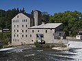
In 1877, the county opened the Wellington County House of Industry and Refuge, or Poorhouse as it was called, on Wellington Road 18 between Fergus and Elora. Over the years, approximately 1500 deserving poor, including those who were destitute, old and infirm or suffering from disabilities were housed here. The sixty bed house for inmates was surrounded by a 30-acre "industrial" farm with a barn for livestock that produced some of the food for the 70 residents and the staff and also provided work for them. Others worked in the House itself. According to a 2009 report by the Toronto Star, "pauperism was considered a moral failing that could be erased through order and hard work". A hospital was added in 1892. A nearby cemetery has 271 plots for those who died. In 1947 the House was converted into the Wellington County Home for the Aged and in 1975 the building reopened as the Wellington County Museum and Archives. [21] [22] [23]
A historic plaque was erected at the museum, indicating that the "government-supported poorhouse" was "the shelter of last resort for the homeless and destitute, who traded spartan accommodations for domestic or agricultural labour". [24]
As a census division in the 2021 Census of Population conducted by Statistics Canada, Wellington County had a population of 241,026 living in 91,822 of its 97,287 total private dwellings, a change of 8.2% from its 2016 population of 222,726. With a land area of 2,665.36 km2 (1,029.10 sq mi), it had a population density of 90.4/km2 (234.2/sq mi) in 2021. [25]
Panethnic group | 2021 [26] | 2016 [27] | 2011 [28] | 2006 [29] | 2001 [30] | |||||||||
---|---|---|---|---|---|---|---|---|---|---|---|---|---|---|
Pop. | % | Pop. | % | Pop. | % | Pop. | % | Pop. | % | |||||
European [lower-alpha 1] | 192,185 | 80.77% | 188,570 | 85.94% | 181,980 | 88.39% | 179,595 | 90.41% | 169,820 | 91.87% | ||||
South Asian | 12,760 | 5.36% | 7,355 | 3.35% | 5,370 | 2.61% | 4,145 | 2.09% | 3,125 | 1.69% | ||||
Southeast Asian [lower-alpha 2] | 7,790 | 3.27% | 5,835 | 2.66% | 5,110 | 2.48% | 3,745 | 1.89% | 2,615 | 1.41% | ||||
African | 6,870 | 2.89% | 3,280 | 1.49% | 1,975 | 0.96% | 1,790 | 0.9% | 1,965 | 1.06% | ||||
East Asian [lower-alpha 3] | 5,500 | 2.31% | 5,250 | 2.39% | 4,175 | 2.03% | 3,760 | 1.89% | 3,565 | 1.93% | ||||
Middle Eastern [lower-alpha 4] | 3,895 | 1.64% | 2,535 | 1.16% | 1,650 | 0.8% | 1,605 | 0.81% | 975 | 0.53% | ||||
Indigenous | 3,810 | 1.6% | 3,385 | 1.54% | 3,200 | 1.55% | 1,815 | 0.91% | 1,260 | 0.68% | ||||
Latin American | 2,525 | 1.06% | 1,525 | 0.7% | 1,370 | 0.67% | 1,235 | 0.62% | 795 | 0.43% | ||||
Other [lower-alpha 5] | 2,575 | 1.08% | 1,690 | 0.77% | 1,055 | 0.51% | 940 | 0.47% | 735 | 0.4% | ||||
Total responses | 237,930 | 98.72% | 219,415 | 98.51% | 205,885 | 98.81% | 198,635 | 99.11% | 184,840 | 98.68% | ||||
Total population | 241,026 | 100% | 222,726 | 100% | 208,360 | 100% | 200,425 | 100% | 187,313 | 100% | ||||
Note: Totals greater than 100% due to multiple origin responses |
In October 2008, the County of Wellington was named one of Canada's Top 100 Employers by Mediacorp Canada Inc. and featured in Maclean's newsmagazine. [31] Later that month, the county was recognized as one of Waterloo Area's Top Employers and featured in the Guelph Mercury newspaper. [32]
In 2014, the County of Wellington received Best Health and Wellness Strategy at the Canadian HR Awards. This award recognizes excellence in the area of corporate health and well-being.
In 2013 (Gold), and again in 2014 (Silver), the County of Wellington received Canada's Safest Employer in the Public Sector Award. Canada's Safest Employers Awards recognize organizations from all across Canada with outstanding accomplishments in promoting the health and safety of their workers.
In 2014 (Gold), and again in 2016 (Silver), the County of Wellington received Canada's Psychological Safety Award. Canada's Safest Employer Awards introduced a new Psychological Safety Award in 2014 to recognize organizations that are committed to employee mental health and are working towards implementing the National Standard for Psychological Health and Safety in the Workplace.
The County of Wellington in Ontario, Canada, embarked on the BR+E journey beginning in 2013. Two years later, the county has reaped significant rewards with the candle on the cake represented by two BREI awards at the BREI Annual Conference in 2014.
The County of Wellington proudly received the 2015 Employer of Distinction Award at an Award Ceremony presented by the Guelph and District Human Resources Professionals Association in Guelph.
In early 2018, Alma resident Jim deBock received the Ontario Medal for Good Citizenship for his extensive volunteer work. [33]
Wellington County is part of the Hills of Headwaters Tourism Association and Central Counties of Ontario, two tourism related associations.
In addition to the Museum, attractions in the County recommended by users of the Tripadvisor web site include Elora Rapids, Elora Gorge Conservation Area, the Fergus Grand Theatre and the Elora Cataract Railway. [34] Popular parks with lakes for day use include Rockwood Conservation Area and Belwood Lake. [35]
Guelph is a city in Southwestern Ontario, Canada. Known as The Royal City, it is roughly 22 km (14 mi) east of Kitchener and 70 km (43 mi) west of Downtown Toronto, at the intersection of Highway 6, Highway 7 and Wellington County Road 124. It is the seat of Wellington County, but is politically independent of it.
The Regional Municipality of York, also called York Region, is a regional municipality in Southern Ontario, Canada, between Lake Simcoe and Toronto. The region was established after the passing of then Bill 102, An Act to Establish The Regional Municipality of York, in 1970. It replaced the former York County in 1971, and is part of the Greater Toronto Area and the inner ring of the Golden Horseshoe. The regional government is headquartered in Newmarket.
The Regional Municipality of Durham, informally referred to as Durham Region, is a regional municipality in Southern Ontario, Canada. Located east of Toronto and the Regional Municipality of York, Durham forms the east-end of the Greater Toronto Area and part of the Golden Horseshoe region. It has an area of approximately 2,500 km2 (970 sq mi). The regional government is headquartered in Whitby.
The Greater Toronto Area, commonly referred to as the GTA, includes the City of Toronto and the regional municipalities of Durham, Halton, Peel, and York. In total, the region contains 25 urban, suburban, and rural municipalities. The Greater Toronto Area begins in Burlington in Halton Region, and extends along Lake Ontario past downtown Toronto eastward to Clarington in Durham Region.
The Golden Horseshoe is a secondary region of Southern Ontario, Canada, which lies at the western end of Lake Ontario, with outer boundaries stretching south to Lake Erie and north to Lake Scugog, Lake Simcoe and Georgian Bay of Lake Huron. The region is the most densely populated and industrialized in Canada. Based on the 2021 census, with a population of 7,759,635 people in its core and 9,765,188 in its greater area, the Golden Horseshoe accounts for over 20 percent of the population of Canada and more than 54 percent of Ontario's population. It is part of the Quebec City–Windsor Corridor, itself part of the Great Lakes megalopolis.
Northumberland County is an upper-tier municipality situated on the north shore of Lake Ontario, east of Toronto in Central Ontario. The Northumberland County headquarters are located in Cobourg.
Peterborough County is located in Southern Ontario, Canada. The county seat is The City of Peterborough, which is independent of the county.
The Regional Municipality of Niagara, also colloquially known as the Niagara Region or Region of Niagara, is a regional municipality comprising twelve municipalities of Southern Ontario, Canada. The regional seat is in Thorold. It is the southern end of the Golden Horseshoe, the largest megalopolis in Canada.
Haldimand County is a rural city-status single-tier municipality on the Niagara Peninsula in Southern Ontario, Canada, on the north shore of Lake Erie, and on the Grand River. Despite its name, it is no longer a county by definition, as all municipal services are handled by a single level of government. Municipal offices are located in Cayuga.
The Regional Municipality of Halton, or Halton Region, is a regional municipality in Ontario, Canada, located in the Golden Horseshoe of Southern Ontario. It comprises the city of Burlington and the towns of Oakville, Milton, and Halton Hills. Policing in the Region is provided by the Halton Regional Police Service. The regional council's headquarters are located in Oakville. Burlington, Oakville, and Milton are largely urban and suburban, while Halton Hills is more rural.
Elora is a community in the township of Centre Wellington, Wellington County, Ontario, Canada. It is well known for its 19th-century limestone architecture and the geographically significant Elora Gorge.
Centre Wellington is a township in south-central Ontario, Canada, located in Wellington County. The primary communities are Elora and Fergus. The area is agricultural but also includes industries such as manufacturing. In the Canada 2016 Census, the population was stated as 28,191.
Simcoe County is located in the central portion of Southern Ontario, Canada. The county is just north of the Greater Toronto Area, stretching from the shores of Lake Simcoe in the east to Georgian Bay in the west. Simcoe County forms part of the Greater Golden Horseshoe area, a densely populated and industrialized region, centred on the Greater Toronto Area.
The Township of Perth South is a lower-tier municipality in southwestern Ontario, Canada. It is in Perth County at the confluence of the Thames and Avon rivers. The township was created on January 1, 1998, from the amalgamation of the former Township of Blanshard and the former Township of Downie. The land area of Perth South is 393.14 square kilometers. The population in 2016 was 3,810.
Dufferin County is a county and census division located in Central Ontario, Canada. The county seat is Orangeville, and the current Warden is Wade Mills. The current chief administrative officer is Sonya Pritchard. Dufferin covers an area of 1,486.31 square kilometres (573.87 sq mi), and its population was 61,735 at the time of the 2016 Census.
Grey County is a county of the Canadian province of Ontario. The county seat is in Owen Sound. It is located in the subregion of Southern Ontario named Southwestern Ontario. Grey County is also a part of the Georgian Triangle. At the time of the Canada 2016 Census the population of the county was 93,830.
A visible minority is defined by the Government of Canada as "persons, other than aboriginal peoples, who are non-Caucasian in race or non-white in colour". The term is used primarily as a demographic category by Statistics Canada, in connection with that country's Employment Equity policies. The qualifier "visible" was chosen by the Canadian authorities as a way to single out newer immigrant minorities from both Aboriginal Canadians and other "older" minorities distinguishable by language and religion, which are "invisible" traits.
Wellington—Halton Hills is a federal electoral district in Ontario, Canada, that has been represented in the House of Commons of Canada since 2004.
The demographics of Metro Vancouver indicate a multicultural and multiracial region. Metro Vancouver is a metropolitan area, with its major urban centre being Vancouver, British Columbia, Canada. The Vancouver census metropolitan area, as defined by Statistics Canada, encompasses roughly the same territory as the Metro Vancouver Regional District, a regional district in British Columbia. The regional district includes 23 local authorities. Figures provided here are for the Vancouver census metropolitan area and not for the City of Vancouver.
In the 2021 Census, the City of Calgary had a population of 1,306,784 residents, representing 30.7% of the 4,262,635 residents in all of Alberta, and 3.5% compared to a population of 36,991,981 in all of Canada. The total population of the Calgary census metropolitan area (CMA) was 1,481,806. Calgary is the largest city in Alberta, and the third-largest municipality and fifth-largest metropolitan area in Canada, as of 2021.