
Seaforth is a Southern Ontario community in the municipality of Huron East, in Huron County, Ontario, Canada.

Chatsworth is a township municipality in south-western Ontario, Canada, in Grey County, located at the headwaters of the Styx River, the Saugeen River, the Sauble River, the Bighead River, the Spey River, and the old Sydenham River.

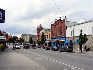
Fergus is the largest community in Centre Wellington, a township within Wellington County in Ontario, Canada. It lies on the Grand River about 18 km NNW of Guelph. The population of this community at the time of the 2016 Census was 20,767, but the community is growing as new homes are being built for sale.

Perth County is a county in the Canadian province of Ontario in Southwestern Ontario, 100 kilometres (62 mi) west of Toronto. Its population centres are Listowel, Mitchell and Milverton. The City of Stratford and the Town of St. Marys are within the Perth census division, but are separate from Perth County. Perth County's 2016 population was 38,066.

Kemptville is a community located in the Municipality of North Grenville in Eastern Ontario, Canada in the northernmost part of the United Counties of Leeds and Grenville. It is located approximately 56 km (35 mi) south of the downtown core of Ottawa and 2.5 to 3 km south of the Rideau River.

Vankleek Hill is a community in Champlain township in eastern Ontario, situated 94 kilometres east of Downtown Ottawa.
Ponsonby is an unincorporated rural community on Wellington County Road 7 in Centre Wellington township, Ontario, Canada.

Edwardsburgh/Cardinal is a township in the United Counties of Leeds and Grenville of eastern Ontario, Canada. Edwardsburgh township was first surveyed in 1783, and incorporated in 1850. The township was part of the historical Grenville County before it merged with Leeds County to form the United Counties in the 19th century.
Minto is a town in midwestern Ontario, Canada, on the Maitland River in Wellington County. Minto is the western terminus of Highway 9. It is named for Gilbert Elliot-Murray-Kynynmound, 4th Earl of Minto; 8th Governor General of Canada.

Palmerston is an unincorporated community in the south end of the town of Minto, in the north part of Wellington County, in Ontario, Canada.
Harriston is a community in the Town of Minto in Wellington County, Ontario, Canada. In 1999, Harriston was amalgamated with the communities of Palmerston, Clifford, and Minto Township to form the Town of Minto. Harriston is located at the headwaters of the Maitland River, and has several shops, restaurants, a library, an art gallery and cultural centre.

Clifford is an unincorporated community in the Town of Minto in Wellington County in Southwestern Ontario, Canada. It is on Ontario Highway 9 and Coon Creek, a stream in the Saugeen River drainage basin.

The Western Ontario Athletic Association (WOAA) is the governing body of minor and senior sports in a region encompassing Grey County, Bruce County, Perth County, Huron County, northern Middlesex County, and northern Wellington County. The WOAA Senior Hockey League has been around since 1948.

Ayton is a community in the municipality of West Grey, Grey County, Ontario, Canada.

Drayton is a community in Wellington County, Ontario, Canada. It is a part of the township of Mapleton. The village is on the corner of Wellington Road 8 and Wellington Road 11, geographically northwest of Fergus and southwest of Arthur.

The Township of Perth East is a municipality in Perth County, Ontario, Canada and situated north of Stratford. It was created in 1998 when the Ontario government amalgamated the village of Milverton with the surrounding former townships of Ellice, Mornington, North Easthope and South Easthope.

West Perth is a municipality in Ontario, Canada, situated in Western Perth County, just west of the city of Stratford. In 2016, its population was 8,865 in a land area of 579.36 square kilometers. The former town of Mitchell and townships of Logan, Hibbert, and Fullarton all amalgamated into this single large municipality on January 1, 1998. Municipal offices, administration, and services are based in Mitchell. Its mayor is Walter McKenzie.
Cotswold is a small community located in the Town of Minto, in the northern part of Wellington County in southern Ontario, Canada. Cotswold was originally a separate community, but was amalgamated with other communities to create the Town of Minto.

Breslau is a community located within the township of Woolwich, part of the Waterloo Regional Municipality in Ontario Canada. Separated from the city of Kitchener by the Grand River, Breslau is named after the former German city of Breslau, now Wrocław, capital of Poland's Lower Silesia.
Teviotdale is a community which lies on the border between Perth County and Wellington County, Ontario, Canada. Teviotdale is the most northernly community in Perth County.
