Perth is a town in Eastern Ontario, Canada. It is located on the Tay River, 83 kilometres (52 mi) southwest of Ottawa, and is the seat of Lanark County.
Wellington County is a county located in Southwestern Ontario, Canada and is part of the Greater Golden Horseshoe. The county, made up of two towns and five townships, is predominantly rural in nature. However many of the residents in the southern part of the county commute to urban areas such as Guelph, Kitchener, Waterloo, Brampton, Mississauga, Toronto and Hamilton for employment. The northern part of the county is made up of mainly rural farming communities, except for a few larger towns such as Mount Forest and Arthur. According to the 2021 census, the population of the county was 241,026.

Mount Forest is an unincorporated community located at the junction of Highway 6 and Highway 89 in the township of Wellington North, Ontario, Canada. As of the 2021 Canadian census the population of Mount Forest was 5,040.

The Township of Perth South is a lower-tier municipality in southwestern Ontario, Canada. It is in Perth County at the confluence of the Thames and Avon rivers. The township was created on January 1, 1998, from the amalgamation of the former Township of Blanshard and the former Township of Downie. The land area of Perth South is 393.14 square kilometers. The population in 2016 was 3,810.

Fergus is the largest community in Centre Wellington, a township within Wellington County in Ontario, Canada. It lies on the Grand River about 18 km NNW of Guelph. The population of this community at the time of the 2016 Census was 20,767, but the community is growing as new homes are being built for sale.

Southampton is a community on the shores of Lake Huron in Bruce County, Ontario, Canada. It is close to Port Elgin and is located at the mouth of the Saugeen River in the Saugeen Ojibway Nation Territory. The size of the town is 6.44 square kilometres. The permanent population in 2016 was 3,678, but the summer population is higher since cottagers and campers spend vacation time in the area.
Wellington North was a federal electoral district represented in the House of Commons of Canada from 1867 to 1953. It was located in the province of Ontario.
Wellington—Grey—Dufferin—Simcoe was a federal electoral district represented in the House of Commons of Canada from 1988 to 1997. It was located in the province of Ontario. This riding was created in 1987 from parts of Bruce—Grey, Grey—Simcoe and Wellington—Dufferin—Simcoe ridings.
Minto is a town in midwestern Ontario, Canada, on the Maitland River in Wellington County. Minto is the western terminus of Highway 9. It is named for Gilbert Elliot-Murray-Kynynmound, 4th Earl of Minto; 8th Governor General of Canada.

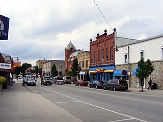
Palmerston is an unincorporated community with a population of 2,599 on the southern edge of Minto in the northwestern part of Wellington County, Ontario.
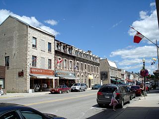
Harriston is a community in the Town of Minto in Wellington County, Ontario, Canada. In 1999, Harriston was amalgamated with the communities of Palmerston, Clifford, and Minto Township to form the Town of Minto. Harriston is located at the headwaters of the Maitland River, and has several shops, restaurants, a library, an art gallery and cultural centre.

Clifford is an unincorporated community in the Town of Minto in Wellington County in Southwestern Ontario, Canada. It is on Ontario Highway 9 and Coon Creek, a stream in the Saugeen River drainage basin.

Drayton is a community in Wellington County, Ontario, Canada. It is a part of the township of Mapleton. The village is on the corner of Wellington Road 8 and Wellington Road 11, geographically northwest of Fergus and southwest of Arthur.

The Township of Perth East is a municipality in Perth County, Ontario, Canada and situated north of Stratford. It was created in 1998 when the Ontario government amalgamated the village of Milverton with the surrounding former townships of Ellice, Mornington, North Easthope and South Easthope.

West Perth is a municipality in Ontario, Canada, situated in Western Perth County, just west of the city of Stratford. In 2016, its population was 8,865 in a land area of 579.36 square kilometers. The former town of Mitchell and townships of Logan, Hibbert, and Fullarton all amalgamated into this single large municipality on January 1, 1998. Municipal offices, administration, and services are based in Mitchell. Its mayor is Walter McKenzie.
Box Grove(Census Tract 5350400.01) is an original community in Markham, Ontario.
King's Highway 23, commonly referred to as Highway 23, is a provincially maintained highway in the Canadian province of Ontario. The route travels from Highway 7 east of Elginfield north to Highway 9 and Highway 89 in Harriston. The total length of Highway 23 is 97.7 kilometres. The highway was first established in 1927 between Highway 8 in Mitchell and Highway 9 in Teviotdale, via Monkton, Listowel and Palmerston. As part of a depression relief program, it was extended south to Highway 7 in 1934. It remained relatively unchanged until 2003, when it was rerouted northward from Palmerston to Harriston.
The Palmerston Railway Heritage Museum is the only original station left in Wellington County, Ontario and one of the few designated as a railway museum in its part of the province. The Palmerston Station is located at 166 William Street, Palmerston, Ontario.

Drew is a rural farming community in Wellington County, Ontario, Canada, forming part of the Town of Minto. From the division of Minto into 18 concessions, Drew emerged from Concessions 16 and 17, spanning approximately five miles. Drew's main attractions include the Drew Ball Diamond and the Drew Community Centre.
The Wellington, Grey and Bruce Railway (WG&BR) was a railway in Ontario, Canada. It ran roughly northwest from Guelph to the port town of Southampton on Lake Huron, a distance of 101 miles (163 km). It also had a 66-mile (106 km) branch line splitting off at Palmerston and running roughly westward to Kincardine, another port town. A branch running south from Southampton was built during the construction of the Bruce Nuclear Generating Station in the 1970s.