Spier, Ontario

Last updated
Spier
Unincorporated rural community
Spier, Ontario.jpg
Second Line in Spier
Canada location map.svg
Red pog.svg
Spier
Canada Ontario location map 2.svg
Red pog.svg
Spier
Coordinates: 43°44′19″N80°21′48″W / 43.73861°N 80.36333°W / 43.73861; -80.36333 Coordinates: 43°44′19″N80°21′48″W / 43.73861°N 80.36333°W / 43.73861; -80.36333
Country Canada
Province Ontario
County Wellington
Township Centre Wellington
Time zone UTC-5 (Eastern (EST))
  Summer (DST) UTC-4 (EDT)
GNBC CodeFCRCY [1]

Spier (also Spires) is an unincorporated rural community in Centre Wellington Township, Wellington County, Ontario, Canada. [1] [2] The settlement was part of West Garafraxa Township until 1999. [3] [4]

Centre Wellington Township in Ontario, Canada

Centre Wellington is a township in south-central Ontario, Canada, located in Wellington County. The primary communities are Elora and Fergus. The area is agricultural but also includes industries such as manufacturing. In the Canada 2016 Census, the population was stated as 28,191.

Wellington County, Ontario County in Ontario, Canada

Wellington County is a county located in Southwestern Ontario, Canada and is part of the Greater Golden Horseshoe. The County, made up of two towns and five townships, is predominantly rural in nature. However many of its residents commute to urban areas such as Guelph, Kitchener, Waterloo, Brampton, Mississauga, Toronto and Hamilton for employment. According to the 2016 Census, the population of the County was 90,932.

History

Forbes Moir emigrated from Aberdeenshire, Scotland in 1858, and purchased 250 acres (100 ha) in the area. Moir went on to serve as councillor, deputy reeve, reeve, auditor, and school trustee in West Garafraxa Township. [5] [6]

Aberdeenshire Council area of Scotland

Aberdeenshire is one of the 32 council areas of Scotland.

When the Credit Valley Railway was constructed in 1879, a portion ran through Forbes Moir's property, and Spires became a flag stop located there. The line was later owned by the Ontario and Quebec Railway, and then Canadian Pacific Railway. The line was abandoned in 1988, and has been converted into the Elora Cataract Trailway, a 47 km (29 mi) recreational rail trail. [5] [7] [8] [9] [10]

Credit Valley Railway

The Credit Valley Railway was a railway located in Ontario, Canada from Toronto to St. Thomas. Chartered in 1871 by Ontario railway magnate George Laidlaw, it operated as an independent company until 1883 when it was leased by the Ontario and Quebec Railway, a Canadian Pacific Railway (CPR) operating company building a network of lines in southern Ontario.

The Ontario and Quebec Railway (O&Q) was a historic railway located in southern and eastern Ontario, Canada. It was initially chartered in March 1881 by managers of the Canadian Pacific Railway to run between Toronto and Perth, where it would connect, via a short branch line, to the CPR-controlled Brockville and Ottawa Railway. Construction began in 1882, and the line was completed in August 1884.

Canadian Pacific Railway railway in Canada

The Canadian Pacific Railway (CPR), also known formerly as CP Rail between 1968 and 1996, is a historic Canadian Class I railroad incorporated in 1881. The railroad is owned by Canadian Pacific Railway Limited, which began operations as legal owner in a corporate restructuring in 2001.

Spires post office was located at the settlement from 1882 to 1913, where Forbes Moir served as postmaster for over 20 years. [5] [6]

Related Research Articles

Caledon, Ontario Town in Ontario, Canada

Caledon is a town in the Regional Municipality of Peel in the Greater Toronto Area of Ontario, Canada. Caledon is a developing urban area although it remains primarily rural. It consists of an amalgamation of a number of urban areas, villages, and hamlets; its major urban centre is Bolton on its eastern side adjacent to York Region.

Elora, Ontario Unincorporated community in Ontario, Canada

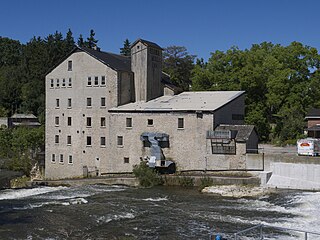
Elora is a community in the township of Centre Wellington, Wellington County, Ontario, Canada. It is well known for its 19th-century limestone architecture and the geographically significant Elora Gorge.

Fergus, Ontario Unincorporated community in Ontario, Canada

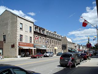
Fergus is the largest community in Centre Wellington, a township within Wellington County in Ontario, Canada. It lies on the Grand River about 18 km NNW of Guelph. The population of this community at the time of the 2016 Census was 20,767, but the community is growing as new homes are being built for sale.

Elora Cataract Trailway rail trail in Ontario

The Elora Cataract Trailway is a 47 km-long recreational rail trail between the towns of Elora and Forks of the Credit, in the south of the province of Ontario, Canada. The former Canadian National Railway line operated from about 1880 until 1988.

Wellington—Grey—Dufferin—Simcoe was a federal electoral district represented in the House of Commons of Canada from 1988 to 1997. It was located in the province of Ontario. This riding was created in 1987 from parts of Bruce—Grey, Grey—Simcoe and Wellington—Dufferin—Simcoe ridings.

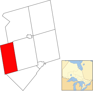
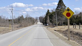
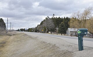
Ponsonby is an unincorporated rural community on Wellington County Road 7 in Centre Wellington township, Ontario, Canada.

Alma, Ontario Unincorporated rural community in Ontario, Canada

Alma is an unincorporated rural community in Mapleton Township, Wellington County, Ontario, Canada.

Perth East, Ontario Township in Ontario, Canada

The Township of Perth East is a municipality in Perth County, Ontario, Canada and situated north of Stratford. It was created in 1998 when the Ontario government amalgamated the village of Milverton with the surrounding former townships of Ellice, Mornington, North Easthope and South Easthope.

John McGowan was an Ontario businessman, farmer and political figure. He represented Wellington North in the Legislative Assembly of Ontario from 1874 to 1879 and Wellington Centre in the House of Commons of Canada as a Liberal-Conservative member from 1901 to 1904.

Grand Valley, Ontario Township in Ontario, Canada

The Town of Grand Valley is a township in the Canadian province of Ontario, composed of the former Township of East Luther and the former Village of Grand Valley. The township is located within Dufferin County, and includes part of the Luther Marsh. The marsh covers over 10,000 acres (40 km²) including Luther Lake. The Grand River is one of the major sites in the town.

Living Springs, Ontario Unincorporated rural community in Ontario, Canada

Living Springs is an unincorporated rural community in Centre Wellington Township, Wellington County, Ontario, Canada. The settlement was part of West Garafraxa Township until 1999.

Kenilworth, Ontario Unincorporated rural community in Ontario, Canada

Kenilworth is an unincorporated rural community in Wellington North Township, Wellington County, Ontario, Canada. Kenilworth was located in Arthur Township until 1999.

Olivet, Ontario Unincorporated rural community in Ontario, Canada

Olivet is an unincorporated rural community in Wellington North Township, Wellington County, Ontario, Canada.

Petherton, Ontario Unincorporated rural community in Ontario, Canada

Petherton is an unincorporated rural community in Wellington North Township, Wellington County, Ontario, Canada. Petherton was located in Arthur Township until 1999.

Riverstown, Ontario Unincorporated rural community in Ontario, Canada

Riverstown is an unincorporated rural community in Wellington North township, Wellington County, Ontario, Canada. Prior to 1999, Riverstown was located in Arthur Township.

Irvine Creek (Ontario)

Irvine Creek is a creek in the municipality of Centre Wellington, Wellington County in southwestern Ontario, Canada. It is in the Great Lakes Basin and is a right tributary of the Grand River.

Riverbank, Ontario Unincorporated rural community in Ontario, Canada

Riverbank is an unincorporated rural community in Mapleton Township, Wellington County, Ontario, Canada. Prior to 1999, Riverbank was located in Maryborough Township.

Cumnock, Ontario Unincorporated rural community in Ontario, Canada

Cumnock is an unincorporated rural community in Centre Wellington Township, Wellington County, Ontario, Canada. Cumnock was part of Nichol Township until 1999.

References

  1. 1 2 "Spier". Natural Resources Canada. October 6, 2016.
  2. "Centre Wellington". Statistics Canada. November 2, 2016.
  3. "Restructuring Flashnews Municipal Restructuring Summary Table". Ontario Ministry of Municipal Affairs. Retrieved May 22, 2017.
  4. "Archive Record". Wellington County Museum and Archives. Retrieved May 29, 2017.
  5. 1 2 3 "Pioneer - MOIR, Forbes". Rootsweb. Retrieved May 29, 2017.
  6. 1 2 "Spires". Library and Archives Canada. May 27, 2014.
  7. Thorning, Stephen. "Oversharp Cattle Buyer Bilked Local Farmers in 1893". The Wellington Advertiser. 41 (42). Retrieved May 29, 2017.
  8. "History of the Trailway". Elora Cataract Trailway. Retrieved May 29, 2017.
  9. "ECTA Trail Map" (PDF). Elora Cataract Trailway. Retrieved May 29, 2017.
  10. "Archive Record". Wellington County Museum and Archives. Retrieved May 29, 2017.