Cumnock, Ontario

Last updated

Cumnock, Ontario
Unincorporated rural community
Cumnock, Ontario.jpg
Highway 6 in Cumnock
Canada location map 2.svg
Red pog.svg
Cumnock, Ontario
Canada Ontario location map 2.svg
Red pog.svg
Cumnock, Ontario
Coordinates: 43°45′35″N80°27′25″W / 43.75972°N 80.45694°W / 43.75972; -80.45694
Country Canada
Province Ontario
County Wellington
Township Centre Wellington
Time zone UTC-5 (Eastern (EST))
  Summer (DST) UTC-4 (EDT)
GNBC CodeFAUXS [1]

Cumnock is an unincorporated rural community in Centre Wellington Township, Wellington County, Ontario, Canada. [1] [2] Cumnock was part of Nichol Township until 1999. [3] [4]

Contents

The settlement is located on Highway 6, 9 km (5.6 mi) northwest of Fergus.

Once a thriving rural community, little remains of the original settlement.

History

The Fergus stage coach, which carried both mail and passengers, stopped in front of the general store and post office in Cumnock (circa 1890) General store - Cumnock, Ontario (circa 1890).jpg
The Fergus stage coach, which carried both mail and passengers, stopped in front of the general store and post office in Cumnock (circa 1890)

James Samson, a Scottish immigrant, purchased 7,367 acres (2,981 ha) of land in the area in 1852. Samson built a general store and tavern along the Owen Sound Road (now Highway 6), and named the settlement after his hometown of Cumnock, Scotland. [6] [7] A post office was established in Samson's store in 1855, with Samson as postmaster. [8]

In 1855, Richard Gluyas laid out Gluyasville a short distance north of Cumnock. Gluyasville was eventually absorbed by Cumnock. [7]

The Wellington, Grey and Bruce Railway built a line through Cumnock in 1871, and a station was built there. [9] [10] That same year, Cumnock was noted as having a saw mill, a wagon maker, and two hotels (the British Hotel and the Red Lion). [10] The Red Lion Hotel was owned by Scottish immigrant John Muir, who "went back to Scotland several times to bring back wives to Cumnock". [6]

The Cumnock Methodist Church was built in 1877. [11]

Cumnock was noted as having a cheese factory in 1880. [12]

Decline

At its peak, Cumnock had a population of 200, though by 1908, the settlement had one hotel, two stores, two churches, and a population of 86. [6] [13]

The post office closed in 1915, and the Methodist church closed in 1924. [8] [11]

An author writing in 1933 described the northern boundary of Nichol Township "where Cumnock used to be", [14] and by 1969, Cumnock was no longer listed on provincial maps. [6]

The railroad line through Cumnock was eventually taken over by Canadian National Railway, and was abandoned in 1983. [9] [10]

Cumnock Tract

In 1964, the County of Wellington purchased two parcels of forested land at Cumnock for recreational use. Located within the westernmost parcel is the Cumnock Tract, a 1.5 km (0.93 mi) walking trail. [15]

Notable people

Related Research Articles

<span class="mw-page-title-main">Erin, Ontario</span> Town in Ontario, Canada

Erin is a town in Wellington County, approximately 80 kilometres (50 mi) northwest of Toronto, Ontario, Canada. Erin is bordered by the Town of Caledon, Ontario to the east, the Town of Halton Hills to the south, the Township of Guelph/Eramosa to the west and the Township of East Garafraxa to the north.

<span class="mw-page-title-main">Elora, Ontario</span> Unincorporated community in Ontario, Canada

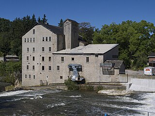
Elora is a community in the township of Centre Wellington, Wellington County, Ontario, Canada. It is well known for its 19th-century limestone architecture and the geographically significant Elora Gorge.

<span class="mw-page-title-main">Woolwich, Ontario</span> Township in Ontario, Canada

The Township of Woolwich is a rural township in Southwestern Ontario, Canada, considered as a municipality. The Township is located in the northeast part of Waterloo Region and is made up of 10 small communities, with Elmira, Ontario the largest and St. Jacobs, Ontario the second largest. The population at the time of the 2021 Census was 26,999, up from the 2016 population of 25,006. Waterloo Region is still home to the largest population of Old Order Mennonites in Canada, particularly in the areas around St Jacobs and Elmira. They are often seen on the local roads using their traditional horse and buggy transportation; many also use horses to pull the implements in their farm fields.

<span class="mw-page-title-main">Centre Wellington</span> Township in Ontario, Canada

Centre Wellington is a township in south-central Ontario, Canada, located in Wellington County. The primary communities are Elora and Fergus. The area is agricultural but also includes industries such as manufacturing. In the Canada 2016 Census, the population was stated as 28,191.

<span class="mw-page-title-main">Mount Forest, Ontario</span> Unincorporated community in Ontario, Canada

Mount Forest is an unincorporated community located at the junction of Highway 6 and Highway 89 in the township of Wellington North, Ontario, Canada. As of the 2011 Canadian census the population of Mount Forest was 4,757.

<span class="mw-page-title-main">Fergus, Ontario</span> Unincorporated community in Ontario, Canada

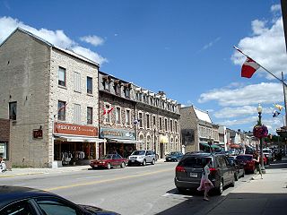
Fergus is the largest community in Centre Wellington, a township within Wellington County in Ontario, Canada. It lies on the Grand River about 18 km NNW of Guelph. The population of this community at the time of the 2016 Census was 20,767, but the community is growing as new homes are being built for sale.

<span class="mw-page-title-main">Stirton, Ontario</span> Unincorporated rural community in Ontario, Canada

Stirton is an unincorporated rural community in Mapleton Township, Wellington County, Ontario, Canada.

<span class="mw-page-title-main">Tara, Ontario</span> Community in Ontario, Canada

Tara is an unincorporated community in the municipality of Arran–Elderslie, Bruce County, in southwestern Ontario, Canada. It is a designated place and had 1,037 residents and 458 dwellings as of the 2011 census. Tara is in geographic Arran Township and is located on the Sauble River. It has an area of 2.39 square kilometres (0.92 sq mi) and an urban area that covers 63.5 square kilometres (24.5 sq mi).

Airlie is an unincorporated rural community in Simcoe County, Ontario, Canada.

<span class="mw-page-title-main">Salem, Wellington County, Ontario</span> Compact Rural Community in Ontario, Canada

Salem is a compact rural community and unincorporated place in the incorporated township of Centre Wellington, Wellington County, in southwestern Ontario, Canada.

<span class="mw-page-title-main">Alma, Ontario</span> Unincorporated rural community in Ontario, Canada

Alma is an unincorporated rural community in Mapleton Township, Wellington County, Ontario, Canada.

<span class="mw-page-title-main">Perth East, Ontario</span> Township in Ontario, Canada

The Township of Perth East is a municipality in Perth County, Ontario, Canada and situated north of Stratford. It was created in 1998 when the Ontario government amalgamated the village of Milverton with the surrounding former townships of Ellice, Mornington, North Easthope and South Easthope.

<span class="mw-page-title-main">Banda, Ontario</span> Unincorporated rural community in Ontario, Canada

Banda is an unincorporated rural community in Dufferin County, Ontario, Canada.

<span class="mw-page-title-main">Living Springs, Ontario</span> Unincorporated rural community in Ontario, Canada

Living Springs is an unincorporated rural community in Centre Wellington Township, Wellington County, Ontario, Canada. The settlement was part of West Garafraxa Township until 1999.

<span class="mw-page-title-main">Spier, Ontario</span> Unincorporated rural community in Ontario, Canada

Spier is an unincorporated rural community in Centre Wellington Township, Wellington County, Ontario, Canada. The settlement was part of West Garafraxa Township until 1999.

<span class="mw-page-title-main">Kenilworth, Ontario</span> Unincorporated rural community in Ontario, Canada

Kenilworth is an unincorporated rural community in Wellington North Township, Wellington County, Ontario, Canada. Kenilworth was located in Arthur Township until 1999.

<span class="mw-page-title-main">Petherton, Ontario</span> Unincorporated rural community in Ontario, Canada

Petherton is an unincorporated rural community in Wellington North Township, Wellington County, Ontario, Canada. Petherton was located in Arthur Township until 1999.

Riverstown is an unincorporated rural community in Wellington North township, Wellington County, Ontario, Canada. Prior to 1999, Riverstown was located in Arthur Township.

<span class="mw-page-title-main">Creek Bank, Ontario</span> Unincorporated rural community in Ontario, Canada

Creek Bank is an unincorporated rural community in Centre Wellington Township, Wellington County, Ontario, Canada.

<span class="mw-page-title-main">Riverbank, Ontario</span> Unincorporated rural community in Ontario, Canada

Riverbank is an unincorporated rural community in Mapleton Township, Wellington County, Ontario, Canada. Prior to 1999, Riverbank was located in Maryborough Township.

References

  1. 1 2 "Cumnock". Natural Resources Canada. October 6, 2016.
  2. "Centre Wellington". Statistics Canada. November 2, 2016.
  3. "Restructuring Flashnews Municipal Restructuring Summary Table". Ontario Ministry of Municipal Affairs. Archived from the original on April 19, 2017. Retrieved May 22, 2017.
  4. The Province of Ontario Gazetteer and Directory. Robertson & Cook. 1869. pp.  126.
  5. "Cumnock General Store/Post Office". Wellington County Museum and Archives. Retrieved May 22, 2017.
  6. 1 2 3 4 "Local Resident Compiles the History of Cumnock". Arthur Enterprise News. October 7, 2010.
  7. 1 2 Rosenthal, Max (February 1965). "Early Post Offices of the Fergus District" (PDF). BNA Topics. British North America Philatelic Society. 22 (2): 37–39. Archived from the original (PDF) on 2017-07-03. Retrieved 2017-05-22.
  8. 1 2 "Cumnock". Library and Archives Canada. May 27, 2014.
  9. 1 2 "The Wellington, Grey & Bruce Railway". Trainweb. December 30, 1997.
  10. 1 2 3 Gazetteer and Directory of the County of Wellington, for 1871-2. A. O. Loomis & Co. 1871. p. 72.
  11. 1 2 Russell, Ken (July 12, 2002). "Cumnock Methodist Church". Rootsweb.
  12. Report of the Commissioners [and Appendices A to S]. Vol. 2. Ontario Agricultural Commission. 1880. p. 632.
  13. Lovell's Gazetteer of the Dominion of Canada (PDF). John Lovell & Son. 1908. p. 418.
  14. Templin, Hugh (1933). Fergus: The Story of a Little Town. Fergus News-Record. p. 27.[ permanent dead link ]
  15. "Wellington Walks 2013" (PDF). County of Wellington. 2013.
  16. Day, Frank (1953). Here and There in Eramosa. Leaman. p. 194.[ permanent dead link ]