Clifford, Ontario

Last updated

Clifford
Unincorporated community
Clifford, Minto, Ontario (21827801332).jpg
Canada Southern Ontario location map 2.png
Red pog.svg
Clifford
Location in southern Ontario
Coordinates: 43°58′09″N80°58′45″W / 43.9692°N 80.9792°W / 43.9692; -80.9792 [1]
Country Canada
Province Ontario
County Wellington
Municipality Minto
Founded (as Minto Village)1855
Present Name1856
Incorporated (village)1873
Amalgamated1999
Named for Clifford in West Yorkshire, England
Elevation
375 m (1,230 ft)
Population
 ( [2] )
  Total800
Time zone UTC-5 (Eastern Time Zone)
  Summer (DST) UTC-4 (Eastern Time Zone)
Postal codes in Canada
Area code(s) 519, 226, 548

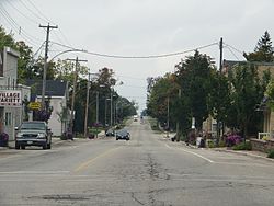
Clifford is an unincorporated community in the Town of Minto in Wellington County in Southwestern Ontario, Canada. [1] It is on Ontario Highway 9 and Coon Creek, a stream in the Saugeen River drainage basin.

Contents

The village of Clifford was founded around 1855 as Minto Village. [3] After the opening of the post office in 1856, the settlement was renamed Clifford by the first postmaster Francis Brown after Clifford in West Yorkshire, England. Clifford was incorporated as a village in 1873. In 1999, Clifford was amalgamated with Palmerston, Harriston and Minto Township to create Minto.

The first telephones in the community were installed in 1890 by Bell Canada. [3] Wightman Telecom, based in Clifford and owned by the Wightman family, has owned and operated a communication system in Clifford since 1908, with a telephone system that was originally operated out of a kitchen in Howick Township. Wightman bought out Bell's operations in Clifford, Ayton and Neustadt in 1928. The firm continues to operate the system as of March 2016. [3] [4]

On 17 March 2016 a 200-metre (660 ft) wide EF1 tornado touched down near the community. [5]

Demographics

In the 2021 Census of Population conducted by Statistics Canada, Clifford had a population of 875 living in 377 of its 389 total private dwellings, a change of

Notable people

Athletes

Musicians

Politicians

Related Research Articles

<span class="mw-page-title-main">Lake of Bays</span> Township municipality in Ontario, Canada

Lake of Bays is a township municipality within the District Municipality of Muskoka, Ontario, Canada. The township, situated 193 kilometres (120 mi) north of Toronto, is named after the Lake of Bays. During the 2016 census, the township had a population of 3,167 and encompassed 677.91 square kilometres (261.74 sq mi) of land.

<span class="mw-page-title-main">Perth South, Ontario</span> Township in Ontario, Canada

The Township of Perth South is a lower-tier municipality in southwestern Ontario, Canada. It is in Perth County at the confluence of the Thames and Avon rivers. The township was created on January 1, 1998, from the amalgamation of the former Township of Blanshard and the former Township of Downie. The land area of Perth South is 393.14 square kilometers. The population in 2016 was 3,810.

<span class="mw-page-title-main">Grey County</span> County in Ontario, Canada

Grey County is a county of the Canadian province of Ontario. The county seat is in Owen Sound. It is located in the subregion of Southern Ontario named Southwestern Ontario. Grey County is also a part of the Georgian Triangle. At the time of the Canada 2016 Census the population of the county was 93,830.

<span class="mw-page-title-main">Perth County, Ontario</span> County in Ontario, Canada

Perth County is a county in the Canadian province of Ontario in Southwestern Ontario, 100 kilometres (62 mi) west of Toronto. Its population centres are Listowel, Mitchell and Milverton. The City of Stratford and the Town of St. Marys are within the Perth census division, but are separate from Perth County. The 2016 population of Perth County was 38,066.

<span class="mw-page-title-main">South Frontenac</span> Township in Ontario, Canada

South Frontenac is a township in Frontenac County in eastern Ontario, Canada. It was amalgamated in 1998 from the former townships of Bedford, Loughborough, Portland, and Storrington.

<span class="mw-page-title-main">Trent Hills</span> Township in Ontario, Canada

The Municipality of Trent Hills is a township municipality in Northumberland County in Central Ontario, Canada. It is on the Trent River and was created in 2001 through the amalgamation of the municipalities of Campbellford/Seymour, Percy Township and Hastings. Thereafter it was known in brief as Campbellford/Seymour, Percy, Hastings.

<span class="mw-page-title-main">Laurentian Valley</span> Township municipality in Ontario, Canada

Laurentian Valley is a township municipality in Renfrew County in eastern Ontario, Canada. It borders on the Ottawa River, the city of Pembroke and the town of Petawawa.

<span class="mw-page-title-main">Tara, Ontario</span> Community in Ontario, Canada

Tara is an unincorporated community in the municipality of Arran–Elderslie, Bruce County, in southwestern Ontario, Canada. It is a designated place and had 1,037 residents and 458 dwellings as of the 2011 census. Tara is in geographic Arran Township and is located on the Sauble River. It has an area of 2.39 square kilometres (0.92 sq mi) and an urban area that covers 63.5 square kilometres (24.5 sq mi).

<span class="mw-page-title-main">Nipissing, Ontario</span> Township in Ontario, Canada

Nipissing is an incorporated (political) township in Parry Sound District in Central Ontario, Canada. It is on Lake Nipissing and is part of the Almaguin Highlands region. Nipissing was surveyed between 1874 and 1881, and was incorporated in 1888. Among the first settlers in the area were the Chapman and Beatty families. Nipissing Township annexed Gurd Township in 1970. The township also contains a community named Nipissing, which is located on the South River near Chapman's Landing, on the South Bay of Lake Nipissing. The township administrative offices are located in Nipissing.

<span class="mw-page-title-main">Minto, Ontario</span> Town in Ontario, Canada

Minto is a town in midwestern Ontario, Canada, on the Maitland River in Wellington County. Minto is the western terminus of Highway 9. It is named for Gilbert Elliot-Murray-Kynynmound, 4th Earl of Minto; 8th Governor General of Canada.

<span class="mw-page-title-main">Harriston, Ontario</span> Unincorporated community in Ontario, Canada

Harriston is a community in the Town of Minto in Wellington County, Ontario, Canada. In 1999, Harriston was amalgamated with the communities of Palmerston, Clifford, and Minto Township to form the Town of Minto. Harriston is located at the headwaters of the Maitland River, and has several shops, restaurants, a library, an art gallery and cultural centre.

<span class="mw-page-title-main">Perth East, Ontario</span> Township in Ontario, Canada

The Township of Perth East is a municipality in Perth County, Ontario, Canada and situated north of Stratford. It was created in 1998 when the Ontario government amalgamated the village of Milverton with the surrounding former townships of Ellice, Mornington, North Easthope and South Easthope.

<span class="mw-page-title-main">Armour, Ontario</span> Township municipality in Ontario, Canada

Armour is a township municipality in the Canadian province of Ontario.

<span class="mw-page-title-main">The Blue Mountains, Ontario</span> Town in Ontario, Canada

The Blue Mountains is a town in Grey County, southwestern Ontario, Canada, located where the Beaver River flows into Nottawasaga Bay. It is named for the Blue Mountain, and hence the economy of the town is centred on tourism, particularly on the Blue Mountain ski resort and the private Georgian Peaks, Osler, Craigleith and Alpine Ski Clubs.

<span class="mw-page-title-main">West Perth, Ontario</span> Municipality in Ontario, Canada

West Perth is a municipality in Ontario, Canada, situated in Western Perth County, just west of the city of Stratford. In 2016, its population was 8,865 in a land area of 579.36 square kilometers. The former town of Mitchell and townships of Logan, Hibbert, and Fullarton all amalgamated into this single large municipality on January 1, 1998. Municipal offices, administration, and services are based in Mitchell. Its mayor is Walter McKenzie.

<span class="mw-page-title-main">Grand Valley, Ontario</span> Town in Ontario, Canada

Grand Valley is a town in the Canadian province of Ontario. It comprises the former Township of East Luther and the former Village of Grand Valley. The town is located within Dufferin County, and includes part of the Luther Marsh. The marsh covers over 10,000 acres (40 km²) including Luther Lake. The Grand River is one of the major sites in the town.

<span class="mw-page-title-main">Mapleton, Ontario</span> Township in Ontario, Canada

Mapleton is a rural township in the Canadian province of Ontario, located within Wellington County.

<span class="mw-page-title-main">Teviotdale, Ontario</span> Town in Ontario, Canada

Teviotdale is a community which lies on the border between Perth County and Wellington County, Ontario, Canada. Teviotdale is the most northernly community in Perth County.

<span class="mw-page-title-main">Warwick, Ontario</span> Township in Ontario, Canada

Warwick is a rural township in Lambton County, Ontario, Canada, with a population (2016) of 3,692.

<span class="mw-page-title-main">James, Ontario</span> Township in Ontario, Canada

James is an incorporated township in the Canadian province of Ontario, located in Timiskaming District. The primary community within the township is Elk Lake, which is located at the junction of Ontario Highway 65 and Ontario Highway 560.

References

  1. 1 2 "Clifford". Geographical Names Data Base . Natural Resources Canada . Retrieved 2016-03-17.
  2. Taken from Google Earth at geographic coordinates. Accessed 2016-03-17.
  3. 1 2 3 Harrison, Clifford M (1978). "Two towns and a village". The Way It Was : A History of Minto Township. Township of Minto. pp. 114–120. OCLC   63015327 . Retrieved 2016-03-17. Also OCLC   22093320.
  4. "Who is Wightman Telecom?". Wightman Telecom. Archived from the original on 2016-03-24. Retrieved 2016-03-17.
  5. "Environment Canada confirms tornado touched down near Clifford Ont". 680 News. 2016-03-17. Retrieved 2016-03-17.
  6. "Population and dwelling counts: Canada and designated places". Statistics Canada. February 9, 2022. Retrieved Sep 2, 2022.

Other map sources: