
Erin is a town in Wellington County, approximately 80 kilometres (50 mi) northwest of Toronto, Ontario, Canada. Erin is bordered by the Town of Caledon, Ontario to the east, the Town of Halton Hills to the south, the Township of Guelph/Eramosa to the west and the Township of East Garafraxa to the north.

Wellington County is a county located in Southwestern Ontario, Canada and is part of the Greater Golden Horseshoe. The County, made up of two towns and five townships, is predominantly rural in nature. However many of the residents in the southern part of the County commute to urban areas such as Guelph, Kitchener, Waterloo, Brampton, Mississauga, Toronto and Hamilton for employment. The northern part of the county is made up of mainly rural farming communities, except for a few larger towns such as Mount Forest and Arthur. According to the 2016 Census, the population of the County was 90,932.

Puslinch is a township in south-central Ontario, Canada, in Wellington County, surrounding the south end of Guelph. The main source of production is agricultural, spring water bottling and mining. Aggregate mining has been dominant throughout the county. About half of the township is forested, and a conservation area lies to the southwest. Near the western edge of the township, just outside Cambridge, Ontario, is Puslinch Lake, the largest kettle lake in North America. It is part of the Guelph census metropolitan area.
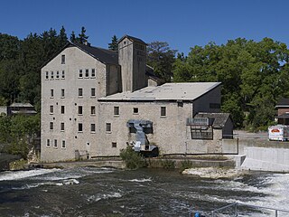
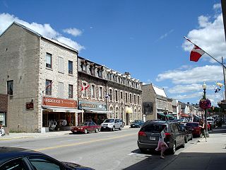
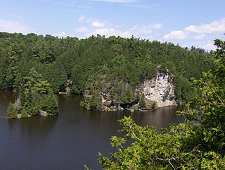
Elora is a community in the township of Centre Wellington, Wellington County, Ontario, Canada. It is well known for its 19th-century limestone architecture and the geographically significant Elora Gorge.

The Township of Wilmot is a rural township in the Regional Municipality of Waterloo in southwestern Ontario, Canada.
Centre Wellington is a township in south-central Ontario, Canada, located in Wellington County. The primary communities are Elora and Fergus. The area is agricultural but also includes industries such as manufacturing. In the Canada 2016 Census, the population was stated as 28,191.

Mount Forest is an unincorporated community located at the junction of Highway 6 and Highway 89 in the township of Wellington North, Ontario, Canada. As of the 2011 Canadian census the population of Mount Forest was 4,757.

Fergus is the largest community in Centre Wellington, a township within Wellington County in Ontario, Canada. It lies on the Grand River about 18 km NNW of Guelph. The population of this community at the time of the 2016 Census was 20,767, but the community is growing as new homes are being built for sale.
Halton County is a former county in the Canadian province of Ontario, with an area of 228,181 acres (923.42 km2). It is also one of the oldest counties in Canada.

The Eramosa River is a river in Wellington County in southwestern Ontario which rises near Erin, Ontario, and flows southwest through the city of Guelph, where it joins the Speed River, which then enters the Grand River in Cambridge. The river is believed to derive its name from the Mississauga word um-ne-mo-sah, meaning "black dog" or "dead dog".
Wellington South was a Canadian federal electoral district represented in the House of Commons of Canada from 1867 to 1968. It was located in the province of Ontario. It was created by the British North America Act of 1867 as the "South Riding of the county of Wellington". The County of Wellington was divided into three ridings: the North, South and Centre Ridings".
Guelph/Eramosa is a township located in Wellington County, in midwestern Ontario, Canada. It partly encircles the city of Guelph, surrounding it in a continuous arc from approximately northeast to south-southwest of the city. It is part of the Guelph census metropolitan area.

Ariss is an unincorporated rural community in Guelph/Eramosa Township, Wellington County, Ontario, Canada.

Alma is an unincorporated rural community in Mapleton Township, Wellington County, Ontario, Canada.

Brucedale is an unincorporated rural community in Guelph/Eramosa Township, Wellington County, Ontario, Canada.

Riverstown is an unincorporated rural community in Wellington North township, Wellington County, Ontario, Canada. Prior to 1999, Riverstown was located in Arthur Township.
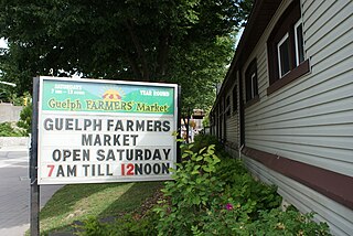
The Guelph Farmers' Market has served as a cultural and commercial anchor in downtown Guelph since the first Market House was built in 1827. After 180 years it is still going strong and remains a popular stop on Saturday mornings for both locals and visitors. The Guelph Farmers' Market's website proclaims "Buy Local - Buy Fresh", reflecting the growing trend to "eat where you live" which is supported by local, national, international organizations and popular opinion.

Creek Bank is an unincorporated rural community in Centre Wellington Township, Wellington County, Ontario, Canada.
Cumnock is an unincorporated rural community in Centre Wellington Township, Wellington County, Ontario, Canada. Cumnock was part of Nichol Township until 1999.


