The Fox River is a river in the north central United States, in eastern Wisconsin. Along the banks is a chain of cities and villages, including Oshkosh, Neenah, Menasha, Appleton, Little Chute, Kimberly, Combined Locks, and Kaukauna. Except for Oshkosh, located on the Upper Fox River near Lake Winnebago, these cities and villages identify as the Fox Cities. Farther north along the Lower Fox River, from its outlet from Lake Winnebago and before its mouth at Lake Michigan, are the cities of De Pere and Green Bay, and the villages of Ashwaubenon and Allouez; although they are in the Fox River Valley, this grouping of cities and villages does not refer to themselves as Fox Cities.

The Township of Woolwich is a rural township in Southwestern Ontario, Canada, considered as a municipality. A full ten small communities make up the Township which is located in the northeast part of Waterloo Region and is made up of 10 small communities, with Elmira, Ontario the largest and St. Jacobs, Ontario the second largest. The population at the time of the 2016 Census was 25,006, up slightly from the 2011 population of 23,145. Waterloo Region is still home to the largest population of Old Order Mennonites in Canada, particularly in the areas around St Jacobs and Elmira. They are often seen on the local roads using their traditional horse and buggy transportation; many also use horses to pull the implements in their farm fields.

The Grand River is a large river in Southwestern Ontario, Canada. It also lies along the western fringe of the Golden Horseshoe region of Ontario which overlaps the eastern portion of southwestern Ontario along the length of this river. From its source near Wareham, Ontario, it flows south through Grand Valley, Fergus, Elora, Waterloo, Kitchener, Cambridge, Paris, Brantford, Caledonia, and Cayuga before emptying into the north shore of Lake Erie south of Dunnville at Port Maitland. One of the scenic and spectacular features of the river is the falls and Gorge at Elora.

The community of St. Jacobs is located in southwest Ontario, just north of Waterloo in Woolwich Township, Waterloo Region. It is a popular location for tourism, due to its quaint village appearance, retail focus and Mennonite heritage. Waterloo Region is still home to the largest population of Old Order Mennonites in Canada, particularly in the areas around St Jacobs and Elmira. They are often seen on the local roads using their traditional horse and buggy transportation; many also use horses to pull the implements in their farm fields.

Bradford is the primary country urban area of the Town of Bradford West Gwillimbury, Ontario, in Canada. It overlooks a farming community, known as The Holland Marsh, located on the Holland River that flows into Lake Simcoe.

Cass Lake is a lake in north central Minnesota in the United States. It is approximately 10 mi (16 km) long and 7 mi (11 km) wide, located in Cass and Beltrami counties, within the Chippewa National Forest and the Leech Lake Indian Reservation, adjacent to its namesake city of Cass Lake. It is the 11th largest lake in Minnesota, and the 8th largest lake lying entirely within the borders of the state.

Fall River is a suburban community in Halifax, Nova Scotia, Canada. It is located north-northeast of the Bedford Basin, northeast of Bedford and Lower Sackville and north of Waverley.

Alma is an unincorporated rural community in Mapleton Township, Wellington County, Ontario, Canada.

The Welland Canal has gone through many incarnations in its history. Today, five distinct canal-construction efforts are recognized. The retronym First Welland Canal is applied to the original canal, constructed from 1824 to 1829 and 1831 to 1833.

Great Falls Dam is a hydroelectric dam on the Caney Fork, straddling the county line between White County and Warren County in the U.S. state of Tennessee. It is the only dam outside the Tennessee River watershed owned and operated by the Tennessee Valley Authority. The dam impounds the 1,830-acre (740 ha) Great Falls Lake, and its tailwaters feed into Center Hill Lake. The completion of Great Falls Dam in 1917 was an engineering triumph, marking the first successful attempt to impound the volatile and flood-prone Caney Fork. The dam is also notable for its design, utilizing a mostly underground conduit to carry water from the reservoir via a tributary to the Power House 0.75 miles (1.21 km) downstream from the dam.

Ear Falls is a community and township located in Northwestern Ontario, Canada, on the right bank of the English River near the outlet of Lac Seul. It is located along Highway 105, 100 kilometres (62 mi) north of Highway 17 and Vermilion Bay, about halfway between Highway 17 and Red Lake, or about 480 kilometres (300 mi) northwest of Thunder Bay.

Spanish is a town in the Canadian province of Ontario, located on Trans-Canada Highway 17 in the Algoma District near the border of the Sudbury District. Formerly known as the Township of Shedden, the municipality adopted its current status and name in 2004, taking the name of its largest community.

Norris Dam State Park is a state park in Anderson County and Campbell County, Tennessee, in the southeastern United States. The park is situated along the shores of Norris Lake, an impoundment of the Clinch River created by the completion of Norris Dam in 1936. The park consists of 4,038 acres (16.34 km2) managed by the Tennessee Department of Environment and Conservation. The park also administers the Lenoir Museum Complex, which interprets the area's aboriginal, pioneer, and early 20th-century history.
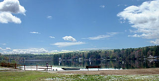
Lake Wyola is a lake located in Shutesbury, Massachusetts, United States.

Conestogo is a community in the Canadian province of Ontario, located in the township of Woolwich in Waterloo Region. The population in 2016 was 1,270.
Sheldrake Lake is a man-made body of water located in the north-eastern section of New Rochelle in Westchester County, New York. It has a surface area of 25 acres and formerly served as the water supply for neighboring Larchmont village. The lake is the result of Larchmont Water Company Dam #2 on the Sheldrake River. The dam, constructed in 1935, is masonry with a height of 31 feet (9.4 m) and a length of 1,000 feet (300 m). The dam has a maximum discharge is 987 cubic feet (27.9 m3) per second and drains an area of 2.66 square miles (6.9 km2).

Creek Bank is an unincorporated rural community in Centre Wellington Township, Wellington County, Ontario, Canada.
Riverbank is an unincorporated rural community in Mapleton Township, Wellington County, Ontario, Canada. Prior to 1999, Riverbank was located in Maryborough Township.
Cumnock is an unincorporated rural community in Centre Wellington Township, Wellington County, Ontario, Canada. Cumnock was part of Nichol Township until 1999.