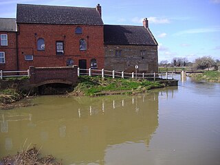
The River Nene is a river in the east of England that rises from three sources in Northamptonshire. The river is about 105 miles (169 km) long, about 3.7 miles (6.0 km) of which forms the border between Cambridgeshire and Norfolk. It is the tenth-longest river in the United Kingdom, and is navigable for 88 miles (142 km), from Northampton to The Wash.

The Chelmer and Blackwater Navigation is the canalisation of the Rivers Chelmer and Blackwater in Essex, in the east of England. The navigation runs for 13.75 miles (22.13 km) from Springfield Basin in Chelmsford to the sea lock at Heybridge Basin near Maldon. Initial plans faced spirited opposition from Maldon, which were overcome by avoiding the town and terminating at Heybridge, and the navigation opened in 1797. There were some teething problems, and the engineer John Rennie was called back on two occasions to recommend improvements. The impact of the railways was less severe than on many canals, as there was never a direct line between Chelmsford and Maldon. The sea lock at Heybridge was enlarged after the Second World War, but trade gradually declined and ceased in 1972.

The River Don is a river in South Yorkshire and the East Riding of Yorkshire, England. It rises in the Pennines, west of Dunford Bridge, and flows for 69 miles (111 km) eastwards, through the Don Valley, via Penistone, Sheffield, Rotherham, Mexborough, Conisbrough, Doncaster and Stainforth. It originally joined the Trent, but was re-engineered by Cornelius Vermuyden as the Dutch River in the 1620s, and now joins the River Ouse at Goole. Don Valley is a UK parliamentary constituency near the Doncaster stretch of the river.

Caledonia is a community located on the Grand River in Haldimand County, Ontario, Canada. It had a population of 12,179 as of the 2021 Canadian Census. Caledonia is within Ward 3 of Haldimand County. The Councillor elected for Ward 3 is Dan Lawrence. As of 2021, there were 4,310 private dwellings in Caledonia.

Bonneville Lock and Dam consists of several run-of-the-river dam structures that together complete a span of the Columbia River between the U.S. states of Oregon and Washington at River Mile 146.1. The dam is located 40 miles (64 km) east of Portland, Oregon, in the Columbia River Gorge. The primary functions of Bonneville Lock and Dam are electrical power generation and river navigation. The dam was built and is managed by the United States Army Corps of Engineers. At the time of its construction in the 1930s it was the largest water impoundment project of its type in the nation, able to withstand flooding on an unprecedented scale. Electrical power generated at Bonneville is distributed by the Bonneville Power Administration. Bonneville Lock and Dam is named for Army Capt. Benjamin Bonneville, an early explorer credited with charting much of the Oregon Trail. The Bonneville Dam Historic District was designated a National Historic Landmark District in 1987.
The Hertford Union Canal or Duckett's Cut, just over 1 mile (1.6 km) long, connects the Regent's Canal to the Lee Navigation in the London Borough of Tower Hamlets in East London. It was opened in 1830 but quickly proved to be a commercial failure. It was acquired by the Regents Canal Company in 1857, and became part of the Grand Union Canal in 1927.

The Grand River, formerly known as The River Ouse, is a large river in Ontario, Canada. It lies along the western fringe of the Greater Golden Horseshoe region of Ontario which overlaps the eastern portion of southwestern Ontario, sometimes referred to as Midwestern Ontario, along the length of this river. From its source near Wareham, Ontario, it flows south through Grand Valley, Fergus, Elora, Waterloo, Kitchener, Cambridge, Paris, Brantford, Oshweken, Six Nations of the Grand River, Caledonia, and Cayuga before emptying into the north shore of Lake Erie south of Dunnville at Port Maitland. One of the scenic and spectacular features of the river is the falls and Gorge at Elora.
The Speed River is a river that flows through Wellington County and the Region of Waterloo in southwestern Ontario, Canada. It flows south from its source near Orton, through Guelph, where it is joined by the Eramosa River, then through the towns of Hespeler and Preston, finally uniting with the Grand River in north-west Cambridge.
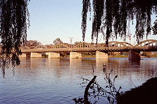
The Caledonia Bridge, also known as the Grand River Bridge is a road bridge located in Caledonia, Ontario, Canada on Argyle Street. The bridge is the only nine-span bridge of its kind in Canada and is considered the first reinforced concrete bridge of its type ever built.

Caledonia railway station was built in 1908 by the Grand Trunk Railway Company of Canada. The station was the third to be built in Caledonia, Ontario.

The Millennium Ribble Link is a linear water park and new navigation which links the once-isolated Lancaster Canal in Lancashire, England to the River Ribble. The Lancaster Canal was never connected to the rest of the English waterways network, because the planned aqueduct over the River Ribble was never built. Instead, a tramway connected the southern and northern parts of the canal. An idea for a connecting link following the course of the Savick Brook was proposed in 1979, and the Ribble Link Trust campaigned for twenty years to see it built. The turn of the Millennium, and the funds available from the Millennium Commission for projects to mark the event was the catalyst for the project to be implemented, and although completion was delayed, the navigation opened in July 2002.

The Lehigh Canal is a navigable canal that begins at the mouth of Nesquehoning Creek on the Lehigh River in the Lehigh Valley and Northeastern regions of Pennsylvania. It was built in two sections over a span of 20 years beginning in 1818. The lower section spanned the distance between Easton and present-day Jim Thorpe. In Easton, the canal met the Delaware and Morris Canals, which allowed anthracite coal and other goods to be transported further up the U.S. East Coast. At its height, the Lehigh Canal was 72 miles (116 km) long.
Indiana is a ghost town in Haldimand County, Ontario, Canada. It was located on the north-east bank of the Grand River, north of Cayuga. The town flourished in the mid- to late 19th century as a mill town and base for the river transport trade. Until the 1860s it was the largest industrial town in Haldimand County, but by 1905 it was largely abandoned. Part of the 1,200-acre (490-hectare) townsite is now included in the Ruthven Park National Historic Site of Canada.

The River Don Navigation was the result of early efforts to make the River Don in South Yorkshire, England, navigable between Fishlake and Sheffield. The Dutch engineer Cornelius Vermuyden had re-routed the mouth of the river in 1626, to improve drainage, and the new works included provision for navigation, but the scheme did not solve the problem of flooding, and the Dutch River was cut in 1635 to link the new channel to Goole. The first Act of Parliament to improve navigation on the river was obtained in 1726, by a group of Cutlers based in Sheffield; the Corporation of Doncaster obtained an Act in the following year for improvements to the lower river. Locks and lock cuts were built and by 1751 the river was navigable to Tinsley.

The Caledonia Mill was a historic mill building located in Caledonia, Ontario, Canada. Built in 1846, it is a heritage property under the Ontario Heritage Act. It was the last timber-frame water-powered mill along the Grand River in Ontario. In 2018 the mill was dismantled by Riverside properties and was rebuilt as an office complex.

The Indian Head River rises on the southern boundary of Hanover, Massachusetts and northern boundary line of Hanson, Massachusetts at the intersection of tributaries from Drinkwater River in Hanover and Indian Head Brook in Hanson. The river then flows east along the Hanover-Pembroke border. The river, 3.7 miles (6.0 km) long, is a tributary of the North River, which flows into Massachusetts Bay. The Indian Head River was an important fishing and water pathway for the Massachuset Indian village of Mattakeeset which was located around the Pembroke Ponds.

The Sleaford Navigation was a 12.5-mile (20.1 km) canalisation of the River Slea in Lincolnshire, England, which opened in 1794. It ran from a junction with the River Witham, near Chapel Hill to the town of Sleaford through seven locks, most of which were adjacent to mills. Lack of finance meant that it stopped short of its intended terminus, but it gradually grew to be successful financially. The coming of the railways in 1857 led to a rapid decline, and it was officially abandoned by an act of Parliament in 1878, but remained open for a further three years. The lower part of it remained navigable until the 1940s, when it was blocked by a sluice.
The Rapidan Dam Canal of the Rappahannock Navigation is a canal intended to safely carry Batteaus, sturdy flat-bottomed boats used primarily for transporting cargo, around the rapids at the confluence of the Rappahannock and Rapidan Rivers. The Rapidan Canal, funded and constructed by The Rappahannock Company, consists of two different canals built at different times. All of the Rappahannock Navigation, of which the Rapidan Canal is a part, is located in the Piedmont region of Virginia. The Confluence, the name used on maps of the day and sometimes maps of today to denote where the two rivers meet, is located where the borders of the Virginia Counties of Spotsylvania, Stafford and Culpeper meet but is owned by the City of Fredericksburg, Virginia. The Rapidan Canal was listed on the Virginia Landmarks Register (VLR) on June 19, 1973, and on the National Register of Historic Places on July 26, 1973.

The Grand Rapids Dam was a dam located on the Wabash River on the state line between Wabash County and Knox County in the U.S. states of Illinois and Indiana. The dam was built in the late 1890s by the Army Corps of Engineers to improve navigation on the Wabash River. The dam was located near Mount Carmel, Illinois.

The Yamhill River lock and dam was completed in 1900. It was built near Lafayette, Oregon, to allow better river transport on the Yamhill River from Dayton, to McMinnville, Oregon. While the Corps of Engineers had recommended against construction of the lock, it was built anyway, largely as a result of political effort by the backers of the project. For almost forty years prior to the lock construction there had been efforts made to construct a lock and dam on the Yamhill River.

