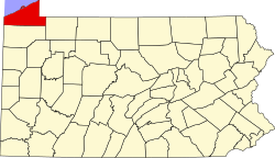
Erie County is the northernmost county in the Commonwealth of Pennsylvania. As of the 2020 census, the population was 270,876.[2] Its county seat is Erie.[3] The county was created in 1800 and later organized in 1803.[4] The county is part of the Northwest region of the commonwealth.[a]
The federal government resolved competing claims over the Erie Triangle in 1792, allowing Pennsylvania to purchase the land. Before the resolution, both New York and Pennsylvania had claimed the territory, preventing the formation of county boundaries. On March 12, 1800, Pennsylvania established Erie County from a portion of Allegheny County, which had absorbed the Erie Triangle following the acquisition. Other states attempted to claim the region, but Pennsylvania ultimately secured the area through formal cession.[5]
Because Erie County and its neighboring counties—Crawford, Mercer, Venango, and Warren—initially lacked the population and resources to sustain independent governments, state officials established a temporary five-county administrative unit based in Meadville, Crawford County, to manage regional affairs. Erie County elected its first local officials in 1803.[6] A fire destroyed the Erie County Courthouse on March 23, 1823, erasing all county records accumulated up to that date.[7]
Immigrants of "Yankee" stock—descendants of English Puritans who originally settled New England—first settled Erie County. These early settlers primarily came from Connecticut, Rhode Island, and Maine, often via Upstate New York. They made Erie County culturally similar to New England rather than to the rest of Pennsylvania.[8] They laid out roads, established post routes, constructed public buildings, and encouraged further migration. Many settlers from upstate New York had only recently relocated there from New England following the American Revolutionary War, creating a strong cultural continuity with early New England.
Erie County was part of the Underground Railroad, giving slaves the ability to gain freedom through Lake Erie into Canada, East through New York State, or to stay in Erie with the help of abolitionists and the free black community.[9]
Geography
According to the U.S. Census Bureau, the county has a total area of 1,558 square miles (4,040km2), of which 799 square miles (2,070km2) is land and 759 square miles (1,970km2) (49%) is water.[10] It is the largest county in Pennsylvania by total area. Except for a high ridge several miles from the lake, running nearly parallel to its shore, the terrain is generally rolling and well-watered.[11] It is the only county in the state that occupies a significant amount of land north of the 42nd parallel.
There are two cities in Erie County: Erie and Corry. Other notable population centers include Millcreek, Harborcreek, Summit, and Fairview townships, as well as the boroughs of Edinboro, North East, Girard, Waterford, and Union City. Erie County is bordered on the northeast by Chautauqua County, New York, on the east by Warren County, on the south by Crawford County, and on the west by Ashtabula County, Ohio. Directly north of the county is Lake Erie. Erie County occupies a position on Lake Erie that makes it the only county in Pennsylvania to share a border with Canada, located across the lake on the far shore.
Most of the county has a warm-summer humid continental climate (Dfb), except at lower elevations near enough to the lake, where a hot-summer humid continental climate (Dfa) exists. Average monthly temperatures in downtown Erie range from 26.4°F in January to 70.8°F in July, while in Corry, they range from 23.8°F in January to 68.2°F in July.[12] The hardiness zone in most of Erie County by area is 6a. It has warmed to 7a along the Lake, and the area between the shore and a line a little south of Interstate 90 is 6b.
Because of its location in the northwesternmost part of the state, Erie County is the only county to border both New York and Ohio. It is also the only county in the state on the Canadian border.
As of the 2020 census, Erie County had a population of 270,876, with 109,371 households and 66,504 families. The median age was 40.6 years; 20.9% of residents were under the age of 18 and 19.0% were 65 years of age or older. For every 100 females there were 97.7 males, and for every 100 females age 18 and over there were 96.1 males age 18 and over.[14]
Of the 109,371 households, 26.8% had children under the age of 18 living in them. Of all households, 42.7% were married-couple households, 20.5% were households with a male householder and no spouse or partner present, and 29.0% were households with a female householder and no spouse or partner present. About 31.3% of all households were made up of individuals and 13.3% had someone living alone who was 65 years of age or older.[14]
There were 119,791 housing units, of which 8.7% were vacant. Among occupied housing units, 65.8% were owner-occupied and 34.2% were renter-occupied. The homeowner vacancy rate was 1.3% and the rental vacancy rate was 8.5%.[14]
76.0% of residents lived in urban areas, while 24.0% lived in rural areas.[15]
Erie County, Pennsylvania – Racial and ethnic composition Note: the US Census treats Hispanic/Latino as an ethnic category. This table excludes Latinos from the racial categories and assigns them to a separate category. Hispanics/Latinos may be of any race.
Ancestry data, based on American Community Survey estimates, indicated that approximately 24 percent of residents were of German descent, 12.5 percent Polish, 12.3 percent Italian, 10.1 percent Irish, 6.5 percent English, and 6.4 percent identified as having "American" ancestry.[20][21]
Before 1960, Erie County was primarily Republican in presidential elections, only backing Democratic Party candidates in four elections from 1888 to 1956. Since 1960, the county has become primarily Democratic, with only five Republican wins in presidential elections from 1960 to the present. Nevertheless, since the 2016 presidential election, the county has become increasingly competitive, with Donald Trump narrowly winning the county that year, followed by Joe Biden narrowly flipping the county in 2020. Most recently, Trump reclaimed it in 2024.[24] Since 1992, the county has voted for the statewide winner in presidential elections, and has done so in all but one since 1948.
United States presidential election results for Erie County, Pennsylvania[25][26]
The county seat of government is in Erie. Erie County operates under a home-rule charter and elects a county executive to manage its government. The current County Executive is Christina Vogel. Vogel assumed the office on January 5, 2026, following the defeat of Brenton Davis. The remaining elected officials of the executive branch are the Erie County Controller, Erie County Coroner, Erie County District Attorney, Erie County Sheriff, and Erie County Clerk of Records. see latest list
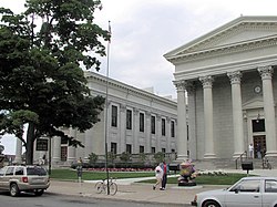
Nine judges serve on the Erie County Court of Common Pleas, and fifteen magisterial district judges preside over the county's district courts. A district court administrator, along with a deputy and an assistant court administrator, manages court operations. Erie County maintains its courthouse near Perry Square in downtown Erie, operates a county prison, and oversees a combined 911/Emergency Management Agency through the Erie County Department of Public Safety in Summit Township.
Politics
As of June 30, 2025, there are 169,450 registered voters in Erie County.
Voter Registration Statistics in Erie County, Pennsylvania (as of Nov 8, 2025)
After years of advocacy on the issue, the Erie County Council approved sponsorship of the Erie County Community College on June 28, 2017. Council Chairman Jay Breneman and colleagues Andre Horton, Kathy Fatica, and Fiore Leone voted in favor of sponsoring the community college, which County Executive Kathy Dahlkemper later signed. The County Executive's administration took the lead in presenting the proposal to the Pennsylvania State Board of Education for approval, supported by a cross-section of business, civic, labor, and community leaders.[30][31]
The Erie County library system operates the foremost public library in Erie, comprising five branches and a bookmobile.[33] In 1996, the county opened the Raymond M. Blasco, M. D. Memorial Library, named for its benefactor.[34] Now called the Main Library or the Erie County Public Library, it ranks as the third-largest library in Pennsylvania.[35] The library relocated from downtown Erie to the bayfront as part of a redevelopment initiative that also introduced the Erie Maritime Museum, Bayfront Convention Center, and Bicentennial Tower on Dobbins Landing. The Main Library features waterfront views of Presque Isle Bay and frequently overlooks the historic U.S. Brig Niagara docked nearby. This relocation, completed approximately 25 years ago, helped revitalize Erie's waterfront, which had remained underdeveloped before the project.[36]
The second floor of the Main Library is home to an art collection, containing historic pieces like Summer Afternoon, Isle of Shoals by Frederick Childe Hassam. The display also features several local artists.[36] The library works with the International Institute of Erie (IIE) to offer tours of the library, a collection of foreign-language books, and other practical information about immigration processes.[36] The library also provides a heritage room where one can conduct genealogy research concerning their ancestors who resided in Erie County or Northwest Pennsylvania.[37]
The four remaining libraries within the Erie County library system are the Edinboro Branch Library, Iroquois Avenue Branch Library, Lincoln Community Center Branch Library, and Millcreek Branch Library.[33] The other public libraries of Erie County include the Albion Area Public Library, Corry Public Library, McCord Memorial Library, Rice Avenue Public Library, Union City Public Library, and Waterford Public Library.[38]
Communities
Map of Erie County, Pennsylvania, with Municipal Labels showing Cities and Boroughs (red), Townships (white), and Census-designated places (blue).
Under Pennsylvania law, there are four types of incorporated municipalities: cities, boroughs, townships, and, in at most two cases, towns. There are 38 incorporated municipalities in Erie County, including 2 cities, 14 boroughs, and 22 townships. Erie County includes the following cities, boroughs, and townships:
Census-designated places are geographical areas designated by the U.S. Census Bureau for the purposes of compiling demographic data. They are not actual jurisdictions under Pennsylvania law. Other unincorporated communities, such as villages, may also be listed here.
↑Whitman, Benjamin; etal. (1884). "Part II, Chapter I". History of Erie County, Pennsylvania: Containing a History of the County, Its Townships, Towns, Villages, Schools, Churches, Industries, Etc. Vol.1. Erie, Pennsylvania: Warner, Beers and Company. p.137.
↑Whitman, Benjamin; etal. (1884). "Chapter XVII County Buildings". History of Erie County, Pennsylvania: Containing a History of the County, Its Townships, Towns, Villages, Schools, Churches, Industries, Etc. Vol.1. Erie, Pennsylvania: Warner, Beers and Company. p.283.
↑Rosenberry, Lois Kimball Mathews (1909). The Expansion of New England: The Spread of New England Settlement and Institutions to the Mississippi River, 1620–1865. Boston: Houghton Mifflin. p.151.
↑Meyer, Melinda.Journey to Freedom National Park Service. Erie County Historical Society. November 17, 2010. http://www.nps.gov. (December 6, 2012)
This page is based on this Wikipedia article Text is available under the CC BY-SA 4.0 license; additional terms may apply. Images, videos and audio are available under their respective licenses.