Northwest Harborcreek, Pennsylvania

Last updated

Northwest Harborcreek, Pennsylvania
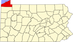
Erie County Pennsylvania incorporated and unincorporated areas Northwest Harborcreek highlighted.svg
Location in Erie County and the U.S. state of Pennsylvania.
Coordinates: 42°8′53″N79°59′44″W / 42.14806°N 79.99556°W / 42.14806; -79.99556
Country United States
State Pennsylvania
County Erie
Township Harborcreek
Area
[1]
  Total5.00 sq mi (12.96 km2)
  Land5.00 sq mi (12.96 km2)
  Water0.00 sq mi (0.00 km2)
Elevation
726 ft (221 m)
Population
 (2020) [2]
  Total8,772
  Density1,753.35/sq mi (676.98/km2)
Time zone UTC-4 (EST)
  Summer (DST) UTC-5 (EDT)
Area code 814
FIPS code 42-55572

Northwest Harborcreek is a census-designated place (CDP) in Erie County, Pennsylvania, United States. The population was 8,949 at the 2010 census. [3] It includes the unincorporated communities of Fairfield and Brookside and is part of the Erie Metropolitan Statistical Area.

Contents

Geography

Northwest Harborcreek occupies the northwestern part of Harborcreek Township in northeastern Erie County. It is located at 42°8′53″N79°59′44″W / 42.14806°N 79.99556°W / 42.14806; -79.99556 (42.148144, -79.995597) [4] and is bordered to the west by Lawrence Park Township, the borough of Wesleyville, and the city of Erie. The northern edge of the CDP is the shore of Lake Erie.

Pennsylvania Route 5 (East Lake Road) runs through the northern (Fairfield) part of the CDP, leading southwest 5 miles (8 km) to downtown Erie and northeast 14 miles (23 km) to the New York state line. U.S. Route 20 (Buffalo Road) runs through the center of the CDP, leading southwest through Wesleyville 4 miles (6 km) into Erie and northeast 10 miles (16 km) to the borough of North East. Pennsylvania Route 430 passes through the southwestern (Brookside) part of the CDP, leading northwest into Wesleyville and southeast 2 miles (3 km) to Interstate 90 at Exit 32.

According to the United States Census Bureau, the CDP has a total area of 5.0 square miles (13.0 km2), all land. [3]

Demographics

Historical population
CensusPop.Note
2020 8,772
U.S. Decennial Census [5]

As of the census [6] of 2000, there were 8,658 people, 3,165 households, and 2,335 families residing in the community. The population density was 1,722.3 inhabitants per square mile (665.0/km2). There were 3,294 housing units at an average density of 655.3 per square mile (253.0/km2). The racial makeup of the community was 97.41% White, 1.39% African American, 0.09% Native American, 0.59% Asian, 0.12% from other races, and 0.40% from two or more races. Hispanic or Latino of any race were 0.44% of the population.

There were 3,165 households, out of which 31.0% had children under the age of 18 living with them, 62.9% were married couples living together, 7.9% had a female householder with no husband present, and 26.2% were non-families. 22.6% of all households were made up of individuals, and 12.0% had someone living alone who was 65 years of age or older. The average household size was 2.60 and the average family size was 3.05.

The population was spread out, with 23.3% under the age of 18, 7.9% from 18 to 24, 24.9% from 25 to 44, 25.4% from 45 to 64, and 18.5% who were 65 years of age or older. The median age was 42 years. For every 100 females, there were 95.7 males. For every 100 females age 18 and over, there were 91.1 males.

The median income for a household in the community was $48,620, and the median income for a family was $55,774. Males had a median income of $41,250 versus $27,295 for females. The per capita income for the community was $21,135. About 2.7% of families and 5.4% of the population were below the poverty line, including 5.5% of those under age 18 and 7.3% of those age 65 or over.

Related Research Articles

Rheems is an unincorporated community and census-designated place (CDP) in Lancaster County, Pennsylvania, United States, between the boroughs of Elizabethtown and Mount Joy. The population was 1,598 during the 2010 census.

<span class="mw-page-title-main">Angola on the Lake, New York</span> Census-designated place in New York, United States

Angola on the Lake is a hamlet and census-designated place (CDP) in Erie County, New York, United States. The population was 1,675 at the 2010 census. It is part of the Buffalo–Niagara Falls Metropolitan Statistical Area.

<span class="mw-page-title-main">Billington Heights, New York</span> Census-designated place in New York, United States

Billington Heights is a hamlet and census-designated place (CDP) in the towns of Elma and Aurora in Erie County, New York, United States. The population was 1,685 at the 2010 census. It is part of the Buffalo–Niagara Falls Metropolitan Statistical Area.

<span class="mw-page-title-main">Lake Erie Beach, New York</span> Census-designated place in New York, United States

Lake Erie Beach is a hamlet and census-designated place (CDP) in the town of Evans, Erie County, New York, United States. The population was 3,872 at the 2010 census. It is part of the Buffalo–Niagara Falls Metropolitan Statistical Area.

<span class="mw-page-title-main">Meadowood, Pennsylvania</span> Census-designated place in Pennsylvania, United States

Meadowood is a census-designated place (CDP) in Butler County, Pennsylvania, United States. The population was 2,693 at the 2010 census.

<span class="mw-page-title-main">Oak Hills, Pennsylvania</span> Census-designated place in Pennsylvania, United States

Oak Hills is a census-designated place (CDP) in Butler County, Pennsylvania, United States. The population was 2,333 at the 2010 census.

<span class="mw-page-title-main">Sandy Ridge, Pennsylvania</span> Census-designated place in Pennsylvania, United States

Sandy Ridge is an unincorporated community and census-designated place (CDP) in Centre County, Pennsylvania, United States. It is part of the State College, Pennsylvania Metropolitan Statistical Area. The population was 407 at the 2010 census.

<span class="mw-page-title-main">Geneva, Pennsylvania</span> Census-designated place in Pennsylvania, United States

Geneva is a census-designated place in Crawford County, Pennsylvania, United States. The population was 109 at the 2010 census.

<span class="mw-page-title-main">Guys Mills, Pennsylvania</span> Census-designated place in Pennsylvania, United States

Guys Mills is a census-designated place in Crawford County, Pennsylvania, United States. The population was 124 at the 2010 census.

<span class="mw-page-title-main">Avonia, Pennsylvania</span> Census-designated place in Pennsylvania, United States

Avonia is an unincorporated community and census-designated place (CDP) in Erie County, Pennsylvania, United States. The population was 1,205 at the 2010 census, down from 1,331 in 2000. It is part of the Erie Metropolitan Statistical Area.

<span class="mw-page-title-main">Elgin, Pennsylvania</span> Borough in Pennsylvania, United States

Elgin is a borough in Erie County, Pennsylvania, United States. The population was 204 at the 2020 census. It is part of the Erie Metropolitan Statistical Area. Places of recreation include Elgin Community Park. Elgin is home to the oldest borough building in Erie County.

<span class="mw-page-title-main">Greenfield Township, Erie County, Pennsylvania</span> Township in Pennsylvania, United States

Greenfield Township is a township in Erie County, Pennsylvania, United States. The population was 1,804 at the 2020 census,

<span class="mw-page-title-main">Harborcreek Township, Erie County, Pennsylvania</span> Township in Pennsylvania, United States

¤

<span class="mw-page-title-main">Lawrence Park Township, Erie County, Pennsylvania</span> 1st Class Township in Pennsylvania, United States

Lawrence Park Township is the only first class township in Erie County, Pennsylvania, United States. The population was 3,821 at the 2020 census, down from 4,048 at the 2000 census. The 2010 census counted a population of 3,982, for a decline of 1.6% during the decade. The entire township is also listed as a census-designated place.

<span class="mw-page-title-main">Wesleyville, Pennsylvania</span> Borough in Pennsylvania, United States

Wesleyville is a borough in Erie County, Pennsylvania, United States. The population was 3,229 at the 2020 census, down from 3,341 in 2010. It is part of the Erie Metropolitan Statistical Area.

<span class="mw-page-title-main">Hiller, Pennsylvania</span> Census-designated place in Pennsylvania, United States

Hiller is an unincorporated community and census-designated place in Fayette County, Pennsylvania, United States. As of the 2010 census, it had a population of 1,155, down from 1,234 at the 2000 census.

<span class="mw-page-title-main">Mexico, Juniata County, Pennsylvania</span> Census-designated place in Pennsylvania, United States

Mexico is an unincorporated community and census-designated place (CDP) in Walker Township, Juniata County, Pennsylvania, United States.

Friedens is a census-designated place (CDP) that is part of Somerset Township in Somerset County, Pennsylvania, United States. The population was 1,523 at the 2010 census. It is part of the Johnstown, Pennsylvania Metropolitan Statistical Area.

<span class="mw-page-title-main">Harrison City, Pennsylvania</span> Census-designated place in Pennsylvania, United States

Harrison City is a census-designated place (CDP) in Westmoreland County, Pennsylvania, United States. The population was 174 at the 2020 census.

<span class="mw-page-title-main">Cheektowaga (CDP), New York</span> Census-designated place in New York, United States

Cheektowaga is a suburban community and census-designated place (CDP) in Erie County, New York, United States. The population was 75,178 at the 2010 census, making it the most populous census-designated place in New York. It is within the town of Cheektowaga. The CDP includes Buffalo Niagara International Airport.

References

  1. "ArcGIS REST Services Directory". United States Census Bureau. Retrieved October 12, 2022.
  2. "Census Population API". United States Census Bureau. Retrieved October 12, 2022.
  3. 1 2 "Geographic Identifiers: 2010 Census Summary File 1 (G001): Northwest Harborcreek CDP, Pennsylvania". American Factfinder. U.S. Census Bureau. Archived from the original on February 13, 2020. Retrieved March 22, 2016.
  4. "US Gazetteer files: 2010, 2000, and 1990". United States Census Bureau. February 12, 2011. Retrieved April 23, 2011.
  5. "Census of Population and Housing". Census.gov. Retrieved June 4, 2016.
  6. "U.S. Census website". United States Census Bureau . Retrieved January 31, 2008.