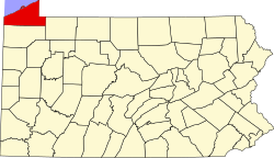
Avonia, Pennsylvania | |
---|---|
Coordinates: 42°3′4″N80°16′13″W / 42.05111°N 80.27028°W Coordinates: 42°3′4″N80°16′13″W / 42.05111°N 80.27028°W | |
Country | United States |
State | Pennsylvania |
County | Erie |
Township | Fairview |
Area | |
• Total | 2.63 sq mi (6.82 km2) |
• Land | 2.63 sq mi (6.81 km2) |
• Water | 0.00 sq mi (0.01 km2) |
Elevation | 675 ft (206 m) |
Population | |
• Total | 1,217 |
• Density | 462.74/sq mi (178.69/km2) |
Time zone | UTC-4 (EST) |
• Summer (DST) | UTC-5 (EDT) |
Area code | 814 |
FIPS code | 42-03676 |
Avonia is an unincorporated community and census-designated place (CDP) in Erie County, Pennsylvania, United States. The population was 1,205 at the 2010 census, [3] down from 1,331 in 2000. It is part of the Erie Metropolitan Statistical Area.
Avonia is located in west-central Erie County at 42°3′4″N80°16′13″W / 42.05111°N 80.27028°W (42.051197, -80.270399), [4] in the northwestern part of Fairview Township. It is bordered to the north by Lake Erie, to the west by Girard Township, and to the south by the Fairview CDP. Pennsylvania Route 5 (West Lake Road) passes through the community, leading northeast 11 miles (18 km) to downtown Erie and southwest 5 miles (8 km) to Lake City. Pennsylvania Route 98 (Avonia Road) intersects PA 5 in the center of Avonia, leading south 1.2 miles (1.9 km) to the center of Fairview and 3 miles (5 km) to Interstate 90.
According to the United States Census Bureau, the Avonia CDP has a total area of 2.7 square miles (6.9 km2), all land. [3]
Historical population | |||
---|---|---|---|
Census | Pop. | %± | |
2020 | 1,217 | — | |
U.S. Decennial Census [5] [2] |
As of the census [6] of 2000, there were 1,331 people, 497 households, and 389 families residing in the community. The population density was 509.0 people per square mile (196.9/km2). There were 540 housing units at an average density of 206.5/sq mi (79.9/km2). The racial makeup of the community was 98.57% White, 0.23% African American, 0.60% Asian, 0.08% from other races, and 0.53% from two or more races. Hispanic or Latino of any race were 0.38% of the population.
There were 497 households, out of which 34.2% had children under the age of 18 living with them, 70.6% were married couples living together, 5.6% had a female householder with no husband present, and 21.7% were non-families. 16.7% of all households were made up of individuals, and 5.2% had someone living alone who was 65 years of age or older. The average household size was 2.68 and the average family size was 3.05.
The population was spread out, with 25.4% under the age of 18, 5.9% from 18 to 24, 25.3% from 25 to 44, 32.1% from 45 to 64, and 11.3% who were 65 years of age or older. The median age was 42 years. For every 100 females, there were 102.6 males. For every 100 females age 18 and over, there were 98.2 males.
The median income for a household in Avonia was $54,821, and the median income for a family was $60,865. Males had a median income of $41,779 versus $35,069 for females. The per capita income for the community was $25,709. About 1.7% of families and 2.0% of the population were below the poverty line, including 3.5% of those under age 18 and none of those age 65 or over.
Comins Township is a civil township of Oscoda County in the U.S. state of Michigan. The population was 1,970 at the 2010 census.
Fairview is an unincorporated community and census-designated place (CDP) located within Middletown Township, in Monmouth County, New Jersey, United States. As of the 2010 United States Census, the CDP's population was 3,806.
Angola on the Lake is a hamlet and census-designated place (CDP) in Erie County, New York, United States. The population was 1,675 at the 2010 census. It is part of the Buffalo–Niagara Falls Metropolitan Statistical Area.
Elma Center is a hamlet and census-designated place (CDP) in the town of Elma in Erie County, New York, United States. As of the 2010 census, this community population was 2,571. It is part of the Buffalo–Niagara Falls Metropolitan Statistical Area.
Lake Erie Beach is a hamlet and census-designated place (CDP) in the town of Evans, Erie County, New York, United States. The population was 3,872 at the 2010 census. It is part of the Buffalo–Niagara Falls Metropolitan Statistical Area.
Fairview Lanes is an unincorporated community in Perkins Township, Erie County, Ohio, United States. The area was delineated as a census-designated place (CDP) for the 2000 census, at which time its population was 1,015. The area was not a CDP for the 2010 census. It is part of the Sandusky, Ohio Metropolitan Statistical Area.
Amity Gardens is a census-designated place (CDP) in Amity Township, Berks County, Pennsylvania, United States. As of the 2010 census, the CDP had a total population of 3,402.
Spring Mills is an unincorporated community and census-designated place (CDP) in Centre County, Pennsylvania, United States. It is part of the State College, Pennsylvania Metropolitan Statistical Area. The population was 268 at the 2010 census.
Pymatuning Central is a census-designated place (CDP) in Crawford County, Pennsylvania, United States. The population was 2,269 at the 2010 census.
Fairview Township is a township in Erie County, Pennsylvania, United States. Situated on the southern shore of Lake Erie, it was one of the county's sixteen original townships, and was founded in 1797.
Girard is a borough in Erie County, Pennsylvania, United States. The population was 2,994 at the 2020 census. It is part of the Erie Metropolitan Statistical Area.
Girard Township is a township in Erie County, Pennsylvania, United States. The population was 4,882 at the 2020 census, down from the population of 5,102 at the 2010 census.
Lake City is a borough in Erie County, Pennsylvania, United States. The population was 2,936 at the 2020 census. It is part of the Erie Metropolitan Statistical Area.
Northwest Harborcreek is a census-designated place (CDP) in Erie County, Pennsylvania, United States. The population was 8,949 at the 2010 census. It includes the unincorporated communities of Fairfield and Brookside and is part of the Erie Metropolitan Statistical Area.
Mountain Top is an unincorporated area and census-designated place (CDP) in Luzerne County, Pennsylvania, United States. As of the 2010 census, the CDP population was 10,982.
Reedsville is a census-designated place (CDP) in the Kishacoquillas Valley of Mifflin County, Pennsylvania, United States. The population was 641 at the 2010 census. Reedsville has a high Amish population.
Trevorton is a census-designated place (CDP) in Zerbe Township, Northumberland County, Pennsylvania, United States. The population was 1,834 at the 2010 census.
Friedens is a census-designated place (CDP) that is part of Somerset Township in Somerset County, Pennsylvania, United States. The population was 1,523 at the 2010 census. It is part of the Johnstown, Pennsylvania Metropolitan Statistical Area.
Fairview (CDP) is in Lincoln County, Wyoming, United States. The population was 275 at the 2010 census.
Southport is a census-designated place (CDP) in the town of Southport in Chemung County, New York, United States. The population of the CDP was 7,238 at the 2010 census, out of a total population in the town of 10,940.