Penn State Erie (Behrend), Pennsylvania

Last updated
Penn State Erie (Behrend), Pennsylvania
Erie County Pennsylvania incorporated and unincorporated areas Penn State Erie (Behrend) highlighted.svg
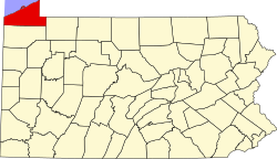
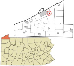
Location in Erie County and the state of Pennsylvania
Coordinates: 42°07′06″N79°58′54″W / 42.11833°N 79.98167°W / 42.11833; -79.98167
Country United States
State Pennsylvania
County Erie
Township Harborcreek
Area
[1]
  Total0.78 sq mi (2.03 km2)
  Land0.78 sq mi (2.03 km2)
  Water0.00 sq mi (0.00 km2)
Elevation
1,070 ft (330 m)
Population
 (2020) [2]
  Total1,486
  Density1,900.26/sq mi (733.25/km2)
Time zone UTC-5 (Eastern (EST))
  Summer (DST) UTC-4 (EDT)
ZIP code
16510 [3]
Area code 814
FIPS code 42-59212
GNIS feature ID2633746

Penn State Erie (Behrend) is a census-designated place [4] located in Harborcreek Township, Erie County in the U.S. state of Pennsylvania. It is located around the campus of Penn State Erie and near the city of Erie. As of the 2010 census the population was 1,629. [5]

Contents

Demographics

As of the 2020 census, there were 1,486 people and 14 housing units. The median age was 19.6 years old. 100% of the residents were in college. The racial demographics of the CDP were 80.6% White, 12.7% African American, 0.4% Asian, 0.8% of people from some other race, and 5.3% from two or more races. Hispanic and/or Latino Americans made up 6% of the population. [6]

The ancestry of the population was 13.3% German, 10.6% Italian, 7.4% Irish, 5.4% Polish, 5.2% Sub-sarahan African, 3.4% Swedish, and 2.1% English. [7] 12.6% of the population spoke a language other than English at home, including Asian and Pacific Islander languages at 6.4%, Other Indo-European languages at 3.0%, and other languages at 2.6%. 9.1% of the population was not born in the United States. [6]

Historical population
CensusPop.Note
2020 1,486
U.S. Decennial Census [8]

Related Research Articles

<span class="mw-page-title-main">Kīlauea, Hawaii</span> Census-designated place in Hawaii, United States

Kīlauea is an unincorporated community and census-designated place (CDP) in Kauaʻi County, Hawaii, United States. As of the 2020 census it had a population of 3,014.

Fort Campbell North is a census-designated place (CDP) in Christian County, Kentucky, United States. It contains most of the housing for the Fort Campbell Army base within the Kentucky portion of the base. The population was 12,825 as of the 2020 census, down from 13,685 in the 2010 census.

<span class="mw-page-title-main">Nixon, Pennsylvania</span> Census-designated place in Pennsylvania, United States

Nixon is a census-designated place (CDP) in Penn Township, Butler County, Pennsylvania, United States. The population was 1,373 at the 2010 census.

<span class="mw-page-title-main">Coburn, Pennsylvania</span> Census-designated place in Pennsylvania, United States

Coburn is a census-designated place (CDP) in Centre County, Pennsylvania, United States. It is part of the State College, Pennsylvania Metropolitan Statistical Area. The population was 236 at the 2010 census.

<span class="mw-page-title-main">Fernville, Pennsylvania</span> Census-designated place in Pennsylvania, United States

Fernville is a census-designated place (CDP) in Columbia County, Pennsylvania, United States. It is part of Northeastern Pennsylvania. The population was 481 at the 2020 census. It is part of the Bloomsburg-Berwick micropolitan area.

<span class="mw-page-title-main">Mainville, Pennsylvania</span> Census-designated place in Pennsylvania, United States

Mainville is a census-designated place in Columbia County, Pennsylvania, United States. It is part of Northeastern Pennsylvania. The population was 134 at the 2020 census. It is part of the Bloomsburg-Berwick micropolitan area.

<span class="mw-page-title-main">Avonia, Pennsylvania</span> Census-designated place in Pennsylvania, United States

Avonia is an unincorporated community and census-designated place (CDP) in Erie County, Pennsylvania, United States. The population was 1,205 at the 2010 census, down from 1,331 in 2000. It is part of the Erie Metropolitan Statistical Area.

<span class="mw-page-title-main">Harborcreek Township, Pennsylvania</span> Township in Pennsylvania, United States

Harborcreek Township is a township in Erie County, Pennsylvania, United States. The population was 16,630 at the 2020 census, down from 17,234 at the 2010 census, up from 15,178 in 2000. It is part of the Erie Metropolitan Statistical Area.

<span class="mw-page-title-main">Northwest Harborcreek, Pennsylvania</span> Census-designated place in Pennsylvania, United States

Northwest Harborcreek is a census-designated place (CDP) in Erie County, Pennsylvania, United States. The population was 8,949 at the 2010 census. It includes the unincorporated communities of Fairfield and Brookside and is part of the Erie Metropolitan Statistical Area.

<span class="mw-page-title-main">Parkville, Pennsylvania</span> CDP in Pennsylvania, United States

Parkville is a census-designated place (CDP) in York County, Pennsylvania, United States. The population was 6,706 at the 2010 census.

<span class="mw-page-title-main">Pennville, Pennsylvania</span> CDP in Pennsylvania, United States

Pennville is a census-designated place (CDP) in York County, Pennsylvania, United States. The population was 1,947 at the 2010 census.

Southport is a census-designated place (CDP) in the town of Southport in Chemung County, New York, United States. The population of the CDP was 7,238 at the 2010 census, out of a total population in the town of 10,940.

Columbia is an unincorporated community and census-designated place (CDP) located within Knowlton Township in Warren County, in the U.S. state of New Jersey. While the community has existed for over a century, the CDP was created as part of the 2010 United States Census. As of the 2010 Census, the CDP's population was 229. The area is served as United States Postal Service ZIP Code 07832.

<span class="mw-page-title-main">Groveville, New Jersey</span> Populated place in Mercer County, New Jersey, US

Groveville is an unincorporated community and census-designated place (CDP) located within Hamilton Township, in Mercer County, in the U.S. state of New Jersey. As of the 2010 United States Census, the CDP's population was 2,945. Before the 2010 Census, the area was part of the Yardville-Groville CDP.

Penryn is an unincorporated community and census-designated place (CDP) in Penn Township, Lancaster County, Pennsylvania, United States. As of the 2010 census the population was 1,024.

<span class="mw-page-title-main">Ellisburg, New Jersey</span> Populated place in Camden County, New Jersey, US

Ellisburg is an unincorporated community and census-designated place (CDP) located within Cherry Hill Township, in Camden County, in the U.S. state of New Jersey. As of the 2010 United States Census, the CDP's population was 8,168. The area had been part of the combined Erlton-Ellisburg CDP, which was discontinued after the 2000 census.

<span class="mw-page-title-main">Lattimer, Pennsylvania</span> Census-designated place in Pennsylvania, United States

Lattimer is a village and census-designated place (CDP) in Hazle Township, Luzerne County, Pennsylvania, United States. The population was 554 at the 2010 census.

Blairstown is an unincorporated community and census-designated place (CDP) located within Blairstown Township, in Warren County, in the U.S. state of New Jersey. The CDP was created as part of the 2010 United States census. As of the 2010 United States census, the CDP's population was 515.

Brookfield is an unincorporated community and census-designated place (CDP) located within White Township, in Warren County, in the U.S. state of New Jersey. As of the 2010 United States Census, the CDP's population was 675.

<span class="mw-page-title-main">Bressler, Pennsylvania</span> Census-designated place in Pennsylvania, United States

Bressler is an unincorporated community and census-designated place (CDP) located in Swatara Township, Dauphin County, in the U.S. state of Pennsylvania. The community was formerly part of the census-designated place of Bressler-Enhaut-Oberlin, before splitting into three separate CDPs for the 2010 census. As of the 2010 census the population of Bressler was 1,437.

References

  1. "ArcGIS REST Services Directory". United States Census Bureau. Retrieved October 16, 2022.
  2. "Census Population API". United States Census Bureau. Retrieved Oct 16, 2022.
  3. "Penn State Erie (Behrend) PA ZIP Code". zipdatamaps.com. 2023. Retrieved May 13, 2023.
  4. "By Decade".
  5. "Geographic Identifiers: 2010 Census Summary File 1 (G001): Penn State Erie (Behrend) CDP, Pennsylvania". American Factfinder. U.S. Census Bureau. Archived from the original on February 13, 2020. Retrieved March 22, 2016.
  6. 1 2 "Explore Census Data". data.census.gov. Retrieved 2024-04-29.
  7. "Explore Census Data". data.census.gov. Retrieved 2024-04-29.
  8. "Census of Population and Housing". Census.gov. Retrieved June 4, 2016.