Sterrettania, Pennsylvania

Last updated

Sterrettania, Pennsylvania
USA Pennsylvania location map.svg
Red pog.svg
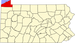
Sterrettania
Location within the state of Pennsylvania
Coordinates: 42°0′16″N80°12′12″W / 42.00444°N 80.20333°W / 42.00444; -80.20333
Country United States
State Pennsylvania
County Erie
Townships Fairview, McKean
Elevation
886 ft (270 m)
Time zone UTC-5 (Eastern (EST))
  Summer (DST) UTC-4 (EDT)

Sterrettania is a populated place located in Erie County, Pennsylvania, United States. It is in Fairview and McKean townships, in the valley of Elk Creek, a short tributary of Lake Erie.

Contents

Sterrettania is an unincorporated community on Pennsylvania Route 832. Sterrettania is located 12 miles (19 km) southwest of downtown Erie and has an elevation of 886 feet (270 m). [1] Sterrettania is not a census designated or incorporated place having an official federally recognized name. Sterrettania appears on the Swanville U.S. Geological Survey Map, is in the Eastern Time Zone (UTC -5 hours) and observes daylight saving time. [2]

Major intersection

West of Sterrettania, Pennsylvania Route 832 intersects with Pennsylvania Route 98. [3]

History

The place is named for Robert Sterrett, who first settled there in 1804. [4] David S. Sterrett built a gristmill there in 1839, one of the largest in the county. [5]

Related Research Articles

<span class="mw-page-title-main">Erie County, Pennsylvania</span> County in Pennsylvania, United States

Erie County is a county in the Commonwealth of Pennsylvania. It is the northernmost county in Pennsylvania. As of the 2020 census, the population was 270,876. Its county seat is Erie. The county was created in 1800 and later organized in 1803.

<span class="mw-page-title-main">Crawford County, Pennsylvania</span> County in Pennsylvania, United States

Crawford County is a county in the Commonwealth of Pennsylvania. As of the 2020 census, the population was 83,938. Its county seat is Meadville. The county was created on March 12, 1800, from part of Allegheny County and named for Colonel William Crawford.

<span class="mw-page-title-main">Easttown Township, Pennsylvania</span> Township in Pennsylvania, United States

Easttown Township is a township in Chester County, Pennsylvania, United States. The population was 10,984 at the 2020 census. The township, which lies in the western half of Philadelphia's Main Line suburbs, is comprised predominantly of parts of two unincorporated areas: Devon and Berwyn. A small portion of the township has a Paoli address.

<span class="mw-page-title-main">Albion, Pennsylvania</span> Borough in Pennsylvania, United States

Albion is a borough in Erie County, Pennsylvania, United States. The population was 1,516 at the 2010 census. It is part of the Erie Metropolitan Statistical Area. One of their main industries is the Albion State Correctional Institute.

<span class="mw-page-title-main">Elgin, Pennsylvania</span> Borough in Pennsylvania, United States

Elgin is a borough in Erie County, Pennsylvania, United States. The population was 204 at the 2020 census. It is part of the Erie Metropolitan Statistical Area. Places of recreation include Elgin Community Park. Elgin is home to the oldest borough building in Erie County.

<span class="mw-page-title-main">Lake City, Pennsylvania</span> Borough in Pennsylvania, United States

Lake City is a borough in Erie County, Pennsylvania, United States. The population was 2,936 at the 2020 census. It is part of the Erie Metropolitan Statistical Area.

<span class="mw-page-title-main">McKean, Pennsylvania</span> Borough in Pennsylvania, United States

McKean is a borough in Erie County, Pennsylvania. The population was 475 at the time of the 2020 census. It is part of the Erie–Meadville combined statistical area. McKean was known as "Middleboro" until it officially changed its name in 1970.

<span class="mw-page-title-main">Waterford, Pennsylvania</span> Borough in Pennsylvania, United States

Waterford is a borough in Erie County, Pennsylvania, United States. The population was 1,475 at the 2020 census. It is part of the Erie Metropolitan Statistical Area.

<span class="mw-page-title-main">Greater Pittsburgh</span> Region in the U.S. State of Pennsylvania

Greater Pittsburgh is the metropolitan area surrounding the city of Pittsburgh in Western Pennsylvania, United States. The region includes Allegheny County, Pittsburgh's urban core county and economic hub, and seven adjacent Pennsylvania counties: Armstrong, Beaver, Butler, Fayette, Lawrence, Washington, and Westmoreland in Western Pennsylvania, which constitutes the Pittsburgh, PA Metropolitan Statistical Area MSA as defined by the U.S. Census Bureau.

<span class="mw-page-title-main">Pennsylvania Route 5</span> State highway in Erie County, Pennsylvania, United States

Pennsylvania Route 5 is a westward continuation of New York State Route 5. Located in the Commonwealth of Pennsylvania, in the United States, it runs from North East, Pennsylvania at the New York-Pennsylvania border to Springfield Township in western Erie County, for a total of 44.85 miles (72.18 km).

<span class="mw-page-title-main">Pennsylvania Route 99</span> State highway in Pennsylvania, US

Pennsylvania Route 99, officially SR 699, is a 21-mile-long (34 km) state highway located in western Pennsylvania. The southern terminus is at U.S. Route 6 and US 19 in Cambridge Springs. The northern terminus is at US 19 near Erie.

<span class="mw-page-title-main">Pennsylvania Route 98</span> State highway in Pennsylvania, US

Pennsylvania Route 98 is a state highway located in western Pennsylvania. The southern terminus of the route is at U.S. Route 6 (US 6)/US 19/US 322 in Vernon Township. The northern terminus is at PA 5 in the borough of Avonia, one mile (1.6 km) from Lake Erie.

<span class="mw-page-title-main">U.S. Route 6N</span>

U.S. Route 6N (US 6N) is a 28-mile-long (45 km) auxiliary route of US 6 that is located in Erie County, Pennsylvania in the United States. The western terminus is situated at US 20 in West Springfield, one-half mile (0.80 km) north of Interstate 90 (I-90) exit 3. Its eastern terminus is located at US 6 and US 19, west of Mill Village.

<span class="mw-page-title-main">Pennsylvania Route 505</span> State highway in Erie County, Pennsylvania, US

Pennsylvania Route 505 is a 2.8-mile-long (4.5 km) state highway located in northwest Pennsylvania. The route is a continuation of PA 97 along the Perry Highway and ends at U.S. Route 20 (US 20) in Erie as Glenwood Park Avenue.

<span class="mw-page-title-main">Pennsylvania Route 832</span> State highway in Erie County, Pennsylvania, US

Pennsylvania Route 832, known locally as Sterrettania Road and Peninsula Drive, is a state highway located in Erie County, Pennsylvania. Its northern terminus is at the entrance to Presque Isle State Park in Erie. The southern terminus is at PA 98, two miles (3 km) west of Sterrettania in Fairview Township. PA 832 has junctions with U.S. Route 20, PA 5 and PA 5 Alternate. PA 832 is exit 18 off Interstate 90 (I-90). PA 832 was designated in 1928 between PA 99 and Presque Isle. The route was extended south to US 20 by 1940. PA 832 was further extended to I-90 by 1959 and PA 98 by 1970.

<span class="mw-page-title-main">Pennsylvania Route 299</span> State highway in Erie County, Pennsylvania, United States

Pennsylvania Route 299 is a 0.05-mile-long state highway located in Erie County in Pennsylvania. The route is the designation for the Staff Sergeant Jeremy R. Horton Memorial Bridge that carries Powell Avenue over two railroad lines in Millcreek Township. PA 299 was designated in 1930 between US 20 and PA 99, which is now PA 5 Alternate, running along Powell Avenue. In 2006, the current bridge over the railroad tracks was built. In 2011, all of PA 299 was decommissioned except for the Staff Sergeant Jeremy R. Horton Memorial Bridge, and is no longer signed as a traffic route. The section of Powell Avenue north of the bridge was realigned in 2012 as a result of runway expansion at Erie International Airport.

<span class="mw-page-title-main">Pennsylvania Route 328</span> State highway in Pennsylvania, US

Pennsylvania Route 328 is a 13.2-mile-long (21.2 km) state highway located in Tioga and Bradford counties in Pennsylvania. The western terminus is at PA 287 in Tioga Junction. The eastern terminus is at New York State Route 328 (NY 328) at the New York state line near Millerton.

<span class="mw-page-title-main">Interstate 90 in Pennsylvania</span> Section of Interstate Highway in Erie County, Pennsylvania, United States

Interstate 90 (I-90) within the US state of Pennsylvania spans 46.297 miles (74.508 km), all within Erie County, from the Ohio border near West Springfield to the New York border near North East. I-90 is the primary west–east highway in the Erie area, passing south of downtown and having interchanges with I-79, which connects Downtown Erie to southern Pennsylvania and beyond, and I-86, linking Erie to the Southern Tier of New York. U.S. Route 20 (US 20), which has an interchange with I-90 near the New York–Pennsylvania border, parallels I-90 across the county. Throughout its length, I-90 has also been designated as the AMVETS Memorial Highway, with signs posted at each state line.

<span class="mw-page-title-main">U.S. Route 20 in Pennsylvania</span>

U.S. Route 20 (US 20) is an east–west United States Numbered Highway in Pennsylvania, which clips the northwestern corner of the state, running entirely in Erie County. While it is part of the nation's longest road, it features the shortest segment of any two-digit U.S. Route in the commonwealth. Although bypassed by Interstate 90 (I-90) as the primary through route in the area, heavy traffic has led to nearly the entire highway being widened to four lanes in width.

The following is a list of former state routes in Pennsylvania. These roads are now either parts of other routes or no longer carry a traffic route number. This list also includes original routes of numbers that were decommissioned and later reactivated in other locations in which most of these are still active today.

References

  1. US Census Map of Erie County, PA
  2. Pennsylvania Hometown Locator
  3. Google Maps
  4. 1884 History of Erie County, PA
  5. Miller, J. A twentieth century history of Erie County, Pennsylvania. p. 189. ISBN   5871217257.