Edinboro, Pennsylvania

Last updated
Edinboro, Pennsylvania
Erie County Pennsylvania incorporated and unincorporated areas Edinboro highlighted.svg
Location in Erie County and the U.S. state of Pennsylvania.
Coordinates: 41°52′56″N80°7′54″W / 41.88222°N 80.13167°W / 41.88222; -80.13167
CountryUnited States
State Pennsylvania
County Erie
Government
  MayorGabriel Williams [1]
Area
[2]
  Total2.40 sq mi (6.23 km2)
  Land2.29 sq mi (5.92 km2)
  Water0.12 sq mi (0.31 km2)
Elevation
[3] (center of downtown)
1,200 ft (400 m)
Highest elevation
[3] (southeast corner of borough)
1,305 ft (398 m)
Lowest elevation
[3] (Conneauttee Creek)
1,180 ft (360 m)
Population
 (2020) [4]
  Total4,964
  Density2,170.53/sq mi (837.91/km2)
Time zone UTC-4 (EST)
  Summer (DST) UTC-5 (EDT)
ZIP code
16412
Area code 814
Website www.edinboro.net

Edinboro is a borough in Erie County, Pennsylvania, United States. It is part of the Erie Metropolitan Statistical Area. As home to Edinboro University of Pennsylvania, it is a small college town, as well as a resort community. The population was 4,920 at the 2020 census, [5] down from 6,438 in 2010. [6]

Contents

The town is located in the snowbelt region south of Lake Erie.

History

Members of the Eriez, Iroquois, and Cornplanter Native tribes were the first known inhabitants of the area that is now known as Edinboro. These nations called the region Conneauttee, meaning "land of the living snowflake". William Culbertson moved to the area in 1801, building a gristmill near Conneauttee Lake. [7]

From 1801 to 1825, the roots of the town were formed when congregations of Presbyterian and Methodist churches began moving to the area and building houses and churches, some of which are still standing today. The first settler, William Culbertson, built the first school around 1825. The first post office was built around 1837 when it was included in the Erie and Crawford counties' postal routes. The farms helped the area grow during this time, and the area was incorporated in 1840 with a population of 232 at about 500 acres (200 ha). A turnpike between Erie and Meadville was constructed in the 1840s; it was made of wooden planks, and completed in 1852. In 1857, an academy was started, which was renamed the State Normal School in 1861, and which would eventually become Edinboro University of Pennsylvania. [7]

A trolley station was built by the railway company (which railway company is apparently unknown). That company built an electric railway in the 1900s which drew more traffic to the area. Fires in 1902, 1905, and 1909, destroyed most of the wood-framed, commercial buildings, many of which were replaced with brick structures that are still standing today. Many more houses, condominiums, and apartments were constructed from 1910 through the 1950s, as Edinboro promoted itself, mainly to the surrounding populations in Pittsburgh and Erie as a resort area by the lake. This promotion boosted tourism, while the college gained enrollment and drew more residents to the town. [7]

The 1960s was a significant growth period for the town, as around 400 building permits were issued for both housing and business. A post office was built in 1960, and evolved to first class status by 1966. The demand for water consumption had tripled throughout this period, and prompted the construction of a new sewage plant in 1970. [7]

The borough's home rule charter was adopted in 1974, with a new municipal building being constructed in 1975. In 1980, the census placed Edinboro first in population growth in Erie County, with a population increase of 30% from 1970 to 1980 to a total of 6,324. The businesses in the borough continued to grow, and in 1983, Edinboro State College received accreditation by the state and was renamed Edinboro University of Pennsylvania. Between the 1980s and 2000s, Edinboro University has grown to be northwestern Pennsylvania's largest university and is a key factor in drawing people to the area. Today, Edinboro is known as a college town in the winter and lake resort during the summer.

Academy Hall was listed on the National Register of Historic Places in 2006. [8]

Geography

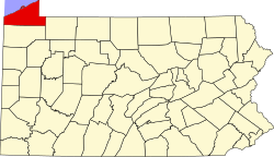
Edinboro is located in southern Erie County at 41°52′36″N80°7′54″W / 41.87667°N 80.13167°W / 41.87667; -80.13167 (41.876558, -80.131661). [9] It is surrounded by Washington Township.

According to the United States Census Bureau, the borough has a total area of 2.4 square miles (6.2 km2), of which 2.3 square miles (5.9 km2) is land and 0.12 square miles (0.3 km2), or 4.95%, is water. [6] The center of the borough is at the south end of Edinboro Lake and around its outlet, Conneauttee Creek, a south-flowing tributary of French Creek and part of the Allegheny River/Ohio River/Mississippi River watershed. Darrows Creek, a tributary of Conneauttee Creek, rises east of town and flows south through the campus of the Edinboro University of Pennsylvania.

U.S. Route 6N passes through the center of Edinboro, leading east 7 miles (11 km) to U.S. Routes 6 and 19 near Mill Village, and west 2.5 miles (4.0 km) to Interstate 79. Pennsylvania Route 99 crosses US 6N in the center of Edinboro, leading north 8 miles (13 km) to McKean and southeast 7 miles (11 km) to Cambridge Springs. The city of Erie is 23 miles (37 km) north via US 6N and I-79.

Demographics

Historical population
CensusPop.Note
1850 264
1860 47479.5%
1870 80169.0%
1880 8769.4%
1890 1,10726.4%
1900 691−37.6%
1910 666−3.6%
1920 83525.4%
1930 789−5.5%
1940 8041.9%
1950 1,56794.9%
1960 1,7038.7%
1970 4,871186.0%
1980 6,32429.8%
1990 7,73622.3%
2000 6,950−10.2%
2010 6,438−7.4%
2020 4,920−23.6%
2021 (est.)4,889 [5] −0.6%
Sources: [10] [11] [12] [4]

As of the census [11] of 2000, there were 6,950 people, 2,087 households, and 830 families residing in the borough. The population density was 3,000.6 inhabitants per square mile (1,158.5/km2). There were 2,242 housing units at an average density of 968.0 per square mile (373.7/km2). The racial makeup of the borough was 92.29% White, 4.45% African American, 0.16% Native American, 1.61% Asian, 0.03% Pacific Islander, 0.52% from other races, and 0.95% from two or more races. Hispanic or Latino of any race were 0.99% of the population.

There were 2,087 households, out of which 19.3% had children under the age of 18 living with them, 29.9% were married couples living together, 8.3% had a female householder with no husband present, and 60.2% were non-families. 29.9% of all households were made up of individuals, and 5.7% had someone living alone who was 65 years of age or older. The average household size was 2.37 and the average family size was 2.93.

In the borough the population was spread out, with 10.8% under the age of 18, 56.6% from 18 to 24, 15.0% from 25 to 44, 10.7% from 45 to 64, and 6.8% who were 65 years of age or older. The median age was 22 years. For every 100 females age 18 and over, there were 84.4 males.

The median income for a household in the borough was $26,652, and the median income for a family was $48,516. Males had a median income of $33,750 versus $24,821 for females. The per capita income for the borough was $12,209. About 11.0% of families and 34.4% of the population were below the poverty line, including 10.8% of those under age 18 and 2.5% of those age 65 or over.

Education

With an enrollment over 8,700, [13] Edinboro University of Pennsylvania, a member of the Pennsylvania State System of Higher Education, is a major contributor to the local economy. Edinboro University was founded in 1857.

Notable people

Related Research Articles

<span class="mw-page-title-main">Erie County, Pennsylvania</span> County in Pennsylvania, United States

Erie County is a county in the Commonwealth of Pennsylvania. It is the northernmost county in Pennsylvania. As of the 2020 census, the population was 270,876. Its county seat is Erie. The county was created in 1800 and later organized in 1803.

<span class="mw-page-title-main">Connoquenessing Township, Butler County, Pennsylvania</span> Township in Pennsylvania, United States

Connoquenessing Township is a township in Butler County, Pennsylvania, United States. The population was 4,265 at the 2020 census.

<span class="mw-page-title-main">Cambridge Township, Crawford County, Pennsylvania</span> Township in Pennsylvania, United States

Cambridge Township is a township in Crawford County, Pennsylvania, United States. The population was 1,447 at the 2020 census.

<span class="mw-page-title-main">Cambridge Springs, Pennsylvania</span> Home rule municipality in Pennsylvania, United States

Cambridge Springs is a borough with home rule status in Crawford County, Pennsylvania, United States. The population was 2,583 at the 2020 census, down from 2,595 at the 2010 census.

<span class="mw-page-title-main">Spring Township, Crawford County, Pennsylvania</span> Township in Pennsylvania, United States

Spring Township is a township in Crawford County, Pennsylvania, United States. The population was 1,407 at the 2020 census, down from 1,548 at the 2010 census.

<span class="mw-page-title-main">Springboro, Pennsylvania</span> Borough in Pennsylvania, United States

Springboro is a borough in Crawford County, Pennsylvania, United States, located 35 miles southwest of Erie. The population was 376 at the 2020 census, down from 477 at the 2010 census.

<span class="mw-page-title-main">Venango Township, Crawford County, Pennsylvania</span> Township in Pennsylvania, United States

Venango Township is a township in Crawford County, Pennsylvania, United States. The population was 941 at the 2020 census, down from 997 at the 2010 census.

<span class="mw-page-title-main">Albion, Pennsylvania</span> Borough in Pennsylvania, United States

Albion is a borough in Erie County, Pennsylvania, United States. The population was 1,516 at the 2010 census. It is part of the Erie Metropolitan Statistical Area. One of their main industries is the Albion State Correctional Institute.

<span class="mw-page-title-main">Franklin Township, Erie County, Pennsylvania</span> Township in Pennsylvania, United States

Franklin Township is a township in Erie County, Pennsylvania, United States. As of the 2020 census, the township population was 1,509, which is down from the population of 1,633 in 2010.

<span class="mw-page-title-main">Girard, Pennsylvania</span> Borough in Pennsylvania, United States

Girard is a borough in Erie County, Pennsylvania, United States. The population was 2,994 at the 2020 census. It is part of the Erie Metropolitan Statistical Area.

<span class="mw-page-title-main">Girard Township, Erie County, Pennsylvania</span> Township in Pennsylvania, United States

Girard Township is a township in Erie County, Pennsylvania, United States. The population was 4,872 at the 2020 census, down from the population of 5,102 at the 2010 census.

<span class="mw-page-title-main">McKean, Pennsylvania</span> Borough in Pennsylvania, United States

McKean is a borough in Erie County, Pennsylvania. The population was 475 at the time of the 2020 census. It is part of the Erie–Meadville combined statistical area. McKean was known as "Middleboro" until it officially changed its name in 1970.

<span class="mw-page-title-main">McKean Township, Pennsylvania</span> Township in Pennsylvania, United States

McKean Township is a township in Erie County, Pennsylvania, United States. The population was 4,435 at the 2020 census, up from 4,409 at the 2010 census, down from 4,619 in 2000.

<span class="mw-page-title-main">Millcreek Township, Erie County, Pennsylvania</span> Township in Pennsylvania

Millcreek Township is a township in Erie County, Pennsylvania, United States. The population was 54,065 at the 2020 census, making it the 14th-largest municipality in the state. and the largest township in Western Pennsylvania.

<span class="mw-page-title-main">North East, Pennsylvania</span> Borough in Pennsylvania, United States

North East is a borough in Erie County, Pennsylvania, United States, 14 miles (23 km) northeast of Erie. Located in the county's northeastern corner, the name comes from the geographical location. The population was 4,114 at the 2020 census, down from 4,294 in 2010. Fruit growing was an early economic endeavor, and is still to this day, as this is a popular area especially for cherries and grapes. There is an annual Cherry Festival in the summer and an annual Wine Country Harvest Festival in autumn. It is part of the Erie Metropolitan Statistical Area. It is the northernmost town in Pennsylvania.

<span class="mw-page-title-main">North East Township, Pennsylvania</span> Township in Pennsylvania, United States

North East Township is a township in Erie County, Pennsylvania, United States. The population was 6,530 at the 2020 census, up from 6,315 at the 2010 census, down from 7,702 in 2000.

<span class="mw-page-title-main">Washington Township, Erie County, Pennsylvania</span> Township in Pennsylvania, United States

Washington Township is a township in Erie County, Pennsylvania, United States. The population was 4,395 at the 2020 census, down from 4,432 at the 2010 census. The township surrounds the borough of Edinboro.

<span class="mw-page-title-main">Waterford, Pennsylvania</span> Borough in Pennsylvania, United States

Waterford is a borough in Erie County, Pennsylvania, United States. The population was 1,475 at the 2020 census. It is part of the Erie Metropolitan Statistical Area.

<span class="mw-page-title-main">Wesleyville, Pennsylvania</span> Borough in Pennsylvania, United States

Wesleyville is a borough in Erie County, Pennsylvania, United States. The population was 3,229 at the 2020 census, down from 3,341 in 2010. It is part of the Erie Metropolitan Statistical Area.

<span class="mw-page-title-main">Clymer Township, Tioga County, Pennsylvania</span> Township in Pennsylvania, United States

Clymer Township is a township in Tioga County, Pennsylvania, United States. The population was 621 at the 2020 census.

References

  1. "Edinboro Council". edinboro.net. Retrieved December 11, 2018.
  2. "ArcGIS REST Services Directory". United States Census Bureau. Retrieved October 12, 2022.
  3. 1 2 3 "Edinboro Topo Map, Erie County PA (Edinboro South Area)". TopoZone. Locality, LLC. Retrieved 2 September 2019.
  4. 1 2 "Census Population API". United States Census Bureau. Retrieved Oct 12, 2022.
  5. 1 2 Bureau, US Census. "City and Town Population Totals: 2020-2021". Census.gov. US Census Bureau. Retrieved 19 July 2022.
  6. 1 2 "Geographic Identifiers: 2010 Demographic Profile Data (G001): Edinboro borough, Pennsylvania". American Factfinder. U.S. Census Bureau. Archived from the original on February 13, 2020. Retrieved March 15, 2016.
  7. 1 2 3 4 "Edinboro Historical Information". Borough of Edinboro official website. Archived from the original on March 16, 2016. Retrieved March 15, 2016.
  8. "National Register Information System". National Register of Historic Places . National Park Service. July 9, 2010.
  9. "US Gazetteer files: 2010, 2000, and 1990". United States Census Bureau. 2011-02-12. Retrieved 2011-04-23.
  10. "Census of Population and Housing". U.S. Census Bureau. Retrieved 11 December 2013.
  11. 1 2 "U.S. Census website". United States Census Bureau . Retrieved 2008-01-31.
  12. "Incorporated Places and Minor Civil Divisions Datasets: Subcounty Resident Population Estimates: April 1, 2010 to July 1, 2012". Population Estimates. U.S. Census Bureau. Archived from the original on 11 June 2013. Retrieved 11 December 2013.
  13. "Published Undergraduate Information" Archived 2012-08-02 at archive.today , Edinboro University of Pennsylvania. Retrieved 2010-10-30.

Commons-logo.svg Media related to Edinboro, Pennsylvania at Wikimedia Commons