Carlisle, Pennsylvania

Last updated

Carlisle, Pennsylvania
Borough
Carlisle, Pennsylvania.jpg
Downtown Carlisle in April 2011
Flag of Carlisle PA.png
Carlisle coat of arms.jpg
Motto: 
"Excellence in Community Service"
Cumberland County Pennsylvania Incorporated and Unincorporated areas Carlisle Highlighted.svg
Location of Carlisle in Cumberland County, Pennsylvania
USA Pennsylvania location map.svg
Red pog.svg
Carlisle
Location of Carlisle in Pennsylvania and the United States
Usa edcp location map.svg
Red pog.svg
Carlisle
Carlisle (the United States)
Coordinates: 40°12′09″N77°11′42″W / 40.20250°N 77.19500°W / 40.20250; -77.19500
CountryUnited States
State Pennsylvania
County Cumberland
Settled1751
Incorporated1782
Named for Carlisle, England
Government
  TypeBorough Council
  MayorSean Shultz (D)
  Deputy MayorBrenda Landis (D)
Area
[1]
  Total5.43 sq mi (14.07 km2)
  Land5.42 sq mi (14.05 km2)
  Water0.01 sq mi (0.02 km2)
Elevation
479 ft (146 m)
Population
 (2020) [2]
  Total20,118
  Density3,709.07/sq mi (1,432.19/km2)
Time zone UTC-5 (Eastern (EST))
  Summer (DST) UTC-4 (EDT)
ZIP Codes
17013, 17015
Area code(s) 717 and 223
FIPS code 42-11272
Website www.carlislepa.org

Carlisle is a borough in and the county seat of Cumberland County, Pennsylvania, United States. [3] Carlisle is located within the Cumberland Valley, a highly productive agricultural region. As of the 2020 census, the borough population was 20,118; [4] including suburbs in the neighboring townships, 37,695 live in the Carlisle urban cluster. Carlisle is the smaller principal city of the Harrisburg–Carlisle metropolitan statistical area, which includes Cumberland and Dauphin and Perry counties in South Central Pennsylvania.

Contents

The U.S. Army War College, located at Carlisle Barracks, prepares high-level military personnel and civilians for strategic leadership responsibilities. Carlisle Barracks ranks among the oldest U.S. Army installations and the most senior military educational institution in the United States Army. Carlisle Barracks is home of the United States Army Heritage and Education Center, an archives and museum complex open to the public. Carlisle also hosts Penn State Dickinson School of Law and Dickinson College.

History

The French-born fur trader James Le Tort may have built a cabin in the area as early as 1720. [5] [6] :113 During the colonial era, Scots-Irish settlers began to settle in the Cumberland Valley beginning in the early 1730s. The settlement of Carlisle, at the intersection of several Indigenous trails, was designated by the Pennsylvania assembly and the Penn family in 1751 as the seat of Cumberland County (named for the county of the same name in England). American engineer John Armstrong Sr., a surveyor for the Penn family, laid the plan for the settlement of Carlisle in 1751. Armstrong Sr. settled there and fathered John Armstrong Jr. in 1758. They named the settlement after its sister town of the same name in Cumberland, England, and even designed its former jailhouse (which now serve as general government offices in the county) to resemble the Carlisle Citadel. [7]

As a result of conflicts on the frontier with Native American tribes, a stockade was constructed in the settlement to protect against potential attacks in 1753. In 1755, the stockade was transformed into a fort, known as Fort Carlisle or Fort Lowther. [8] In 1757, colonel-commandant John Stanwix—for whom Fort Stanwix in upstate New York was named—–established his headquarters in Carlisle, and was promoted to brigadier general on December 27. During the French and Indian War (the North American theater of the Seven Years' War), the largely successful Forbes Expedition was organized in Carlisle in 1758; Henry Bouquet also organized a military expedition from the settlement in 1763 during Pontiac's War.[ citation needed ]

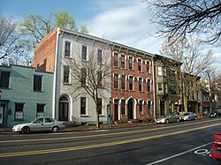
The Pennsylvania guide, compiled by the Writers' Program of the WPA in 1940, described the early history of Carlisle's public square and the physical changes that had occurred by the first half of the 20th century, noting that the square, located at the [9]

intersection of Hanover and High Sts., is now hardly recognizable as such, for the market house, courthouse, and church have encroached on it. But in the early days its limits were clearly defined. The square was the camping ground of Indian delegations in the tense days when the French were invading the Ohio Valley, the gathering place of Revolutionary mass meetings, and the nucleus of a compact little settlement. Here occurred the touching reunion of the Indian captive, Regina, and her mother, after Colonel Bouquet had forced the conquered tribes to surrender their prisoners in 1764. Regina, a German girl whose family name is given variously as Hartman and Leininger, had been taken captive when small, and had forgotten her mother. With tears coursing down her cheeks the mother then sang a song she once had used as a lullaby:

Allein, und doch nicht ganz allein,
Bin ich in meiner Einsamkeit.

[Alone, yet not alone am I, in this
my solitude]

and the long lost daughter rushed into her mother's arms.

Federal Writers'Project, "Part II: Cities and Towns", Pennsylvania: A Guide to the Keystone State (1940)

The settlement of Carlisle was largely supportive of the Patriot cause during the American Revolution, and numerous individuals from the settlement served in the Revolutionary War. Carlisle contains the home of lawyer James Wilson, who served as a representative to the Continental Congress; Wilson was a signer of the Declaration of Independence in addition to being one of the framers of the U.S. Constitution. [10] The First Presbyterian Church, begun in 1757 and completed in 1770, is the oldest building in Carlisle, and was where the Rev. John Steel (known as "The Fighting Parson") gave sermons in support of the Patriot cause during the American Revolution. The church was also where Pennsylvania settlers met on July 12, 1774, to sign a document protesting the Boston Port Act. [11] [12] A year later Carlisle supplied a contingent for a line infantry regiment of the Continental Army. Steel was named commander of the leading company of this group when they marched from Carlisle. [13] No longer standing but marked by a historical marker is the home of Ephraim Blaine, Commissary General of Revolutionary Army. [14] Also, no longer standing but commemorated, is the home of Gen. John Armstrong Sr., "Hero of Kittanning," Revolutionary officer, and member of the Continental Congress. Still standing is the gun shop of Thomas Butler Sr., an Irish immigrant, who manufactured long rifles during the French and Indian War. He later became Chief Armorer for The First Continental Congress. He and his five sons served in the Revolutionary War and were known as "The Fighting Butlers. [15] His eldest son was Richard Butler (general).

Carlisle also served as a munitions depot during the American Revolutionary War. The depot was later developed into the United States Army War College at Carlisle Barracks. Revolutionary War legend Molly Pitcher died in the borough in 1832, and her body lies buried in the Old Public Graveyard. A hotel was built in her honor, called the Molly Pitcher Hotel; it has since been renovated to house apartments for senior citizens.

Carlisle was incorporated as a borough a few years after the war on April 13, 1782. Carlisle continued to play a part in the early development in the United States through the end of the century: In response to a planned march in favor of the United States Constitution in 1787, Anti-Federalists instigated a riot in Carlisle. A decade later, during the Whiskey Rebellion in 1794, the troops of Pennsylvania and New Jersey assembled in Carlisle under the leadership of President George Washington. [16] While in Carlisle, the president worshiped in the First Presbyterian Church at the corner of Hanover Street and High Street.

Benjamin Rush, a signer of the Declaration of Independence, developed Carlisle Grammar School in 1773 and chartered it as Dickinson College—the first new college founded in the newly recognized United States. One of the college's more famous alumni, the 15th U.S. president, James Buchanan, graduated in 1809. [17] The Dickinson School of Law, founded in 1834 and affiliated then with Dickinson College, ranks as the fifth-oldest law school in the United States and the oldest law school in Pennsylvania.

On June 2, 1847, Carlisle was the site of the McClintock Slave Riot, which that broke out after a fugitive slave hearing at the courthouse; several of the fugitive slaves were able to escape during the fray with the help of Carlisle's black residents, while one of the slave catchers later died of his wounds. A Dickinson College professor, John McClintock, was tried and acquitted for his role in the riot. [18]

A general borough law of 1851 (amended in 1852) authorized a burgess and a borough council to administer the government of the borough of Carlisle.

External videos
Carlisle, Pennsylvania (5656229890).jpg
Nuvola apps kaboodle.svg Cumberland County Courthouse Tour, Cumberland County, Pennsylvania, 29:27

Leading up to the American Civil War, Carlisle served as a stop on the Underground Railroad. During the war, an army of the Confederate States of America, under General Fitzhugh Lee, attacked and shelled the borough during the Battle of Carlisle on July 1, 1863, as part of the Gettysburg Campaign. [19] A cannonball dent can still be seen on one of the columns of the historic county courthouse.

United States Army Lieutenant Richard Henry Pratt founded Carlisle Indian Industrial School in 1879 as the first federally supported school for American Indians off a reservation. The United States government maintained the school, housed at Carlisle Barracks as an experiment in educating Native Americans and teaching them to reject tribal culture and to adapt to white society. Pratt retired from the Army in 1903 and from supervising the school as its superintendent in 1904. Athletic hero Jim Thorpe entered the school in 1907 and joined its football team under coach Glenn "Pop" Warner in 1908. Playing halfback, Jim Thorpe led the team to startling upset victories over powerhouses Harvard, Army, and the University of Pennsylvania in 1911–12, bringing nationwide attention to the school. Marianne Moore taught there c. 1910. Carlisle Indian School closed in 1918. [20]

Dickinson School of Law was chartered as an independent institution in 1890. Dickinson School of Law merged into the Pennsylvania State University in 1997 as Penn State Dickinson School of Law.

Carlisle was the original eastern terminus of the Pennsylvania Turnpike when it opened in October 1940. [21]

The Carlisle Historic District, Carlisle Indian Industrial School, Hessian Powder Magazine, Carlisle Armory, and Old West, Dickinson College are listed on the National Register of Historic Places. [22]

Geography

Carlisle is located slightly northeast of the center of Cumberland County at 40°12′9″N77°11′42″W / 40.20250°N 77.19500°W / 40.20250; -77.19500 (40.202553, −77.195016) at an elevation of 479 feet (146 m). [23] [24] The borough lies in the Cumberland Valley, a section of the Great Appalachian Valley, to the south of Conodoguinet Creek, a tributary of the Susquehanna River. Letort Spring Run, a tributary of Conodoguinet Creek, runs north through the eastern part of the borough.

Carlisle lies in south-central Pennsylvania, southwest of the intersection of Interstate 76 (the Pennsylvania Turnpike) and Interstate 81, roughly 20 miles (32 km) west-southwest of Harrisburg, the state capital. By road, it is approximately 80 mi (130 km) northwest of Baltimore and 124 mi (200 km) west-northwest of Philadelphia. [25] According to the United States Census Bureau, Carlisle has a total area of 5.54 square miles (14.35 km2), of which 5.53 square miles (14.33 km2) is land and 0.01 square miles (0.02 km2), or 0.14%, is water. [4]

Climate

Carlisle has a humid continental climate (Köppen Dfa) with hot, humid summers and cool winters. The average temperature in Carlisle is 51.3 °F (10.7 °C) with temperatures exceeding 90 °F (32 °C) an average of 16 days a year and dropping below 32 °F (0 °C) an average of 119 days a year. On average, the borough receives 38.8 inches (986 mm) of precipitation annually. Snowfall averages 29.8 inches (757 mm) per year. [26] On average, January is the coolest month, July is the warmest month, and September is the wettest month. The hottest temperature recorded in Carlisle was 102 °F (39 °C) in 1966; the coldest temperature recorded was −19 °F (−28 °C) in 1994. [27]

Climate data for Carlisle, Pennsylvania, 19912020 normals, extremes 1873present
MonthJanFebMarAprMayJunJulAugSepOctNovDecYear
Record high °F (°C)68
(20)
82
(28)
83
(28)
93
(34)
94
(34)
100
(38)
103
(39)
100
(38)
96
(36)
92
(33)
78
(26)
68
(20)
103
(39)
Mean daily maximum °F (°C)38.1
(3.4)
41.0
(5.0)
50.0
(10.0)
62.6
(17.0)
72.5
(22.5)
81.1
(27.3)
85.5
(29.7)
83.8
(28.8)
77.4
(25.2)
65.9
(18.8)
53.5
(11.9)
42.2
(5.7)
62.8
(17.1)
Daily mean °F (°C)29.3
(−1.5)
31.3
(−0.4)
39.5
(4.2)
50.5
(10.3)
60.7
(15.9)
69.8
(21.0)
74.0
(23.3)
72.3
(22.4)
65.3
(18.5)
53.7
(12.1)
42.9
(6.1)
33.7
(0.9)
51.9
(11.1)
Mean daily minimum °F (°C)20.5
(−6.4)
21.6
(−5.8)
28.9
(−1.7)
38.5
(3.6)
48.9
(9.4)
58.5
(14.7)
62.5
(16.9)
60.8
(16.0)
53.2
(11.8)
41.5
(5.3)
32.3
(0.2)
25.3
(−3.7)
41.0
(5.0)
Record low °F (°C)−12
(−24)
−12
(−24)
2
(−17)
22
(−6)
29
(−2)
42
(6)
45
(7)
45
(7)
32
(0)
17
(−8)
8
(−13)
2
(−17)
−12
(−24)
Average precipitation inches (mm)3.06
(78)
2.58
(66)
4.05
(103)
3.79
(96)
4.73
(120)
4.42
(112)
5.45
(138)
4.03
(102)
4.96
(126)
4.26
(108)
3.13
(80)
3.57
(91)
48.03
(1,220)
Average snowfall inches (cm)7.7
(20)
9.6
(24)
4.8
(12)
0.2
(0.51)
0.0
(0.0)
0.0
(0.0)
0.0
(0.0)
0.0
(0.0)
0.0
(0.0)
0.5
(1.3)
0.9
(2.3)
4.0
(10)
27.7
(70)
Average precipitation days (≥ 0.01 in)8.89.29.411.414.511.811.211.19.010.67.810.3125.1
Average snowy days (≥ 0.1 in)3.23.21.80.20.00.00.00.00.00.10.31.910.7
Source 1: NOAA [28]
Source 2: National Weather Service [29]

Demographics

Historical population
CensusPop.Note
1800 2,052
1810 2,49121.4%
1820 2,90816.7%
1830 3,70827.5%
1840 4,35117.3%
1850 4,5815.3%
1860 5,66423.6%
1870 6,65017.4%
1880 6,209−6.6%
1890 7,62022.7%
1900 9,62626.3%
1910 10,3037.0%
1920 10,9165.9%
1930 12,59615.4%
1940 13,98411.0%
1950 16,81220.2%
1960 16,623−1.1%
1970 18,0798.8%
1980 18,3141.3%
1990 18,4190.6%
2000 17,970−2.4%
2010 18,6824.0%
2020 20,1187.7%
U.S. Decennial Census [30] [2]

As of the census of 2000, there were 17,970 people, 7,426 households, and 4,010 families residing in the borough. The population density was 3,308.9 inhabitants per square mile (1,277.6/km2). There were 8,032 housing units at an average density of 1,479.0 per square mile (571.0/km2). The racial makeup of the borough was 88.93% White, 6.92% African American, 0.14% Native American, 1.60% Asian, 0.02% Pacific Islander, 0.71% from other races, and 1.69% from two or more races. Hispanic or Latino of any race were 1.96% of the population.

There were 7,426 households, out of which 23.3% had children under the age of 18 living with them, 40.3% were married couples living together, 10.9% had a female householder with no husband present, and 46.0% were non-families. 39.3% of all households were made up of individuals, and 14.4% had someone living alone who was 65 years of age or older. The average household size was 2.10 and the average family size was 2.81.

In the borough, the population was spread out, with 18.6% under the age of 18, 17.2% from 18 to 24, 25.3% from 25 to 44, 21.1% from 45 to 64, and 17.8% who were 65 years of age or older. The median age was 36 years. For every 100 females, there were 84.2 males. For every 100 females age 18 and over, there were 80.8 males.

The median income for a household in the borough was $33,969, and the median income for a family was $46,588. Males had a median income of $34,519 versus $25,646 for females. The per capita income for the borough was $21,394. About 8.6% of families and 14.0% of the population were below the poverty line, including 21.7% of those under age 18 and 8.5% of those age 65 or over.

Economy

Leading industries in Carlisle's past have included Carlisle Tire and Rubber Company (founded 1917), Masland Carpets (founded 1866), and The Frog, Switch and Manufacturing. [31] Carlisle Tire and Rubber and Masland Carpets have since gone out of business, and both plants were demolished in 2013. Amazon.com is one of several warehouse facilities in the city. In 2013, Apple opened an AppleCare device repair facility southeast of the Interstate 81 overpass over the Pennsylvania Turnpike to cover American customers east of the Mississippi River. [32]

Arts and culture

Carlisle is famous to many people for its car shows, put on regularly by Carlisle Events throughout the spring, summer, and fall at the Carlisle Fairgrounds. In addition to the regularly scheduled shows there are specialty shows, including the GM Nationals, the Ford Nationals, the Chrysler Nationals, the Truck Nationals, Corvettes at Carlisle, and the Import/Kit Car Nationals.

Partly because of its location at the intersection of two major trucking routes (I-81 and I-76), air pollution within the borough often falls within the range considered by the United States Environmental Protection Agency as "Unhealthy for Sensitive Groups" [i.e., children, the elderly, and people with respiratory or heart disease]. The pollutant typically involved is PM2.5, particulate matter composed of particles less than 2.5 micrometers in diameter. [33]

The Central Pennsylvania Youth Ballet (CPYB), a ballet school and performing company known internationally for their alumni, is based in Carlisle. Students from across the country, and even across the world, come to live with host families to participate in CPYB's rigorous training.

Carlisle is the headquarters of the Giant Food supermarkets in Pennsylvania.

Carlisle was home to the Washington Redskins training camp for many years. In 1986, cornerback Darrell Green ran the 40-yard dash at Dickinson College in 4.09 seconds. Although the result was unofficial, it is the fastest "legitimate" time ever recorded in the 40-yard dash.

Two privately funded historical markers are located in Carlisle: one for the Hamilton Restaurant's Hot-Chee Dog and another for the Old Town Pump, which provided fresh spring water to Carlisle and "eventually became the source of a legend that claimed anyone who drank from the pump would return to Carlisle no matter how far they roamed". [34] [35]

Education

Colleges and universities

Public schools

Private schools

As reported by the National Center for Educational Statistics [36]

Media

Print

Carlisle has one daily newspaper, The Sentinel . [37]

Radio

AM

Frequency Callsign [38] Format [39] City of License Notes
960 WHYL Adult Standards Carlisle, Pennsylvania-
1000 WIOO Country Carlisle, Pennsylvania-

FM

Frequency Callsign [40] Format [39] City of License Notes
88.3 WDCV-FM Variety Carlisle, Pennsylvania Dickinson College radio
93.1 W226AS Contemporary Christian Carlisle, PennsylvaniaTranslator of WBYO, Sellersville, Pennsylvania
97.9 W250AP Country Carlisle, PennsylvaniaTranslator of WIOO
101.7 W269AS Christian Carlisle, Pennsylvania Family Radio translator
102.3 WCAT-FM Country Carlisle, PennsylvaniaBroadcasts from Camp Hill, Pennsylvania

Notable people

Related Research Articles

<span class="mw-page-title-main">Washington County, Pennsylvania</span> County in Pennsylvania, United States

Washington County is a county in the Commonwealth of Pennsylvania, United States. As of the 2020 census, the population was 209,349. Its county seat is Washington.

<span class="mw-page-title-main">Huntingdon County, Pennsylvania</span> County in Pennsylvania, United States

Huntingdon County is a county in the Commonwealth of Pennsylvania. As of the 2020 census, the population was 44,092. Its county seat is Huntingdon. The county was created on September 20, 1787, mainly from the northern part of Bedford County, plus an addition of territory on the east from Cumberland County.

<span class="mw-page-title-main">Dauphin County, Pennsylvania</span> County in Pennsylvania, United States

Dauphin County is a county in the Commonwealth of Pennsylvania. As of the 2020 census, the population was 286,401. The county seat is Harrisburg, Pennsylvania's state capital and ninth-most populous city. The county was created on March 4, 1785, from part of Lancaster County and was named after Louis Joseph, Dauphin of France, the first son of King Louis XVI.

<span class="mw-page-title-main">Centre County, Pennsylvania</span> County in Pennsylvania, United States

Centre County is a county in the Commonwealth of Pennsylvania, United States. As of the 2020 census, the population was 158,172. Its county seat is Bellefonte. Centre County comprises the State College, PA Metropolitan Statistical Area. The northwestern part of Centre County is in the sparsely populated Pennsylvania Wilds region.

<span class="mw-page-title-main">Bedford, Pennsylvania</span> Borough in Pennsylvania, United States

Bedford is a borough and spa town in and the county seat of Bedford County in the U.S. state of Pennsylvania. It is located 102 miles (164 km) west of Harrisburg, the state capital, and 107 miles (172 km) east of Pittsburgh. Bedford's population was 2,865 at the 2020 census.

<span class="mw-page-title-main">Camp Hill, Pennsylvania</span> Borough in Pennsylvania, United States

Camp Hill is a borough in Cumberland County, Pennsylvania, United States. It is 3 miles (5 km) southwest of Harrisburg and is part of the Harrisburg–Carlisle metropolitan statistical area. The population was 8,130 at the 2020 census. There are many large corporations based in nearby East Pennsboro Township and Wormleysburg that use the Camp Hill postal address, including the Harsco Corporation and until 2022 the Rite Aid Corporation.

<span class="mw-page-title-main">Mechanicsburg, Pennsylvania</span> Borough in Pennsylvania, United States

Mechanicsburg is a borough in Cumberland County, Pennsylvania, United States. The borough is eight miles (13 km) west of Harrisburg. It is part of the Harrisburg–Carlisle metropolitan statistical area. As of the 2010 census, it had a population of 8,981. The 2020 census reported the population at 9,311.

<span class="mw-page-title-main">Newville, Pennsylvania</span> Borough in Pennsylvania, United States

Newville is a borough in Cumberland County, Pennsylvania, United States. The borough is located west of Carlisle. The population was 1,376 at the 2020 census. It is part of the Harrisburg–Carlisle metropolitan statistical area.

<span class="mw-page-title-main">North Middleton Township, Pennsylvania</span> Township in Pennsylvania, United States

North Middleton Township is a township in Cumberland County, Pennsylvania, United States. The population was 12,039 at the 2020 census.

<span class="mw-page-title-main">Chambersburg, Pennsylvania</span> Borough in Pennsylvania, United States

Chambersburg is a borough in and the county seat of Franklin County, in the South Central region of Pennsylvania, United States. It is in the Cumberland Valley, which is part of the Great Appalachian Valley, and 13 miles (21 km) north of Maryland and the Mason-Dixon line and 52 miles (84 km) southwest of Harrisburg, the state capital. According to the United States Census Bureau, Chambersburg's 2020 population was 21,903. When combined with the surrounding Greene, Hamilton, and Guilford Townships, the population of Greater Chambersburg is 52,273 people. The Chambersburg, PA Metropolitan Statistical Area includes surrounding Franklin County, and in 2010 included 149,618 people.

<span class="mw-page-title-main">Waynesboro, Pennsylvania</span> Borough in Pennsylvania, United States

Waynesboro is a borough in Franklin County, Pennsylvania, United States. Located on the southern border of the state, Waynesboro is in the Cumberland Valley between Hagerstown, Maryland, and Chambersburg, Pennsylvania. It is part of Chambersburg, PA Micropolitan Statistical Area, which is part of the Washington–Baltimore metropolitan area. It is two miles north of the Mason–Dixon line and close to Camp David and the Raven Rock Mountain Complex.

<span class="mw-page-title-main">Goldsboro, Pennsylvania</span> Borough in Pennsylvania, United States

Goldsboro is a borough in York County, Pennsylvania, United States. The population was 930 at the 2020 census.

<span class="mw-page-title-main">Shippensburg, Pennsylvania</span> Borough in Pennsylvania, United States

Shippensburg is a borough in Cumberland and Franklin counties in the U.S. Commonwealth of Pennsylvania. Settled in 1730, Shippensburg lies in the Cumberland Valley, 41 miles (66 km) southwest of Harrisburg, and is part of the Harrisburg–Carlisle Metropolitan Statistical Area. The population was 5,478 at the 2020 census.

John Armstrong was an American civil engineer and soldier who served as a brigadier general in the Continental Army and as a major general in the Pennsylvania Militia during the Revolutionary War. He was also a delegate to the Continental Congress for Pennsylvania. Armstrong County, Pennsylvania is named in his honor.

<span class="mw-page-title-main">Carlisle Barracks</span> Census-designated place in Pennsylvania, United States

Carlisle Barracks is a United States Army facility located in Carlisle, Pennsylvania. The site of the U.S. Army War College, it is the nation's second-oldest active military base. The first structures were built in 1757, during the French and Indian War between Great Britain and France in the colonies.

<span class="mw-page-title-main">Cumberland County, Pennsylvania</span> County in Pennsylvania, United States

Cumberland County is a county in the Commonwealth of Pennsylvania. As of the 2020 census, the population was 259,469. Its county seat is Carlisle.

<span class="mw-page-title-main">Pennsylvania Route 34</span> State highway in Pennsylvania, US

Pennsylvania Route 34 is a 62-mile-long (100 km) state route located in southern Pennsylvania. The southern terminus of the route is at U.S. Route 15 Business in Gettysburg. The northern terminus is at US 11/US 15 south of Liverpool. PA 34 heads north from Gettysburg through farmland in northern Adams County, passing through Biglerville. The route crosses South Mountain into Cumberland County and reaches Mount Holly Springs, where it intersects PA 94. PA 34 heads north into the agricultural Cumberland Valley and heads north to Carlisle, where it has an interchange with Interstate 81 (I-81) in the southern part of town and intersects US 11/PA 74/PA 641 in the downtown area. The route continues north through more rural land and crosses Blue Mountain into Perry County, where it continues through the Ridge-and-Valley Appalachians, winding north to New Bloomfield. From here, PA 34 continues northeast to Newport, where it crosses the Juniata River and reaches an interchange with US 22/US 322, before heading to its terminus at US 11/US 15 near the Susquehanna River.

<span class="mw-page-title-main">Pennsylvania Route 94</span> State highway in Pennsylvania, US

Pennsylvania Route 94 is a 30-mile (48 km) long north–south state highway located in southern Pennsylvania. The southern terminus of the route is at the Mason–Dixon line, where PA 94 continues into Maryland as Maryland Route 30. The northern terminus is at PA 34 south of Mount Holly Springs. PA 94 heads north-northwest from the state line through southwestern York County, where it passes through Hanover and intersects PA 116/PA 194 in the center of town. Past Hanover, the route heads into rural areas and crosses into the eastern portion of Adams County. Here, PA 94 intersects U.S. Route 30 east of New Oxford, PA 394 in Hampton, PA 234 north of Hampton, and US 15 in York Springs. The route heads into Cumberland County and crosses South Mountain, reaching its end at PA 34. PA 94 is designated as the 94th Infantry Division Memorial Highway for its entire length.

<span class="mw-page-title-main">Harrisburg–Carlisle metropolitan statistical area</span> Metropolitan area in Pennsylvania, United States

The Harrisburg–Carlisle metropolitan statistical area, officially the Harrisburg–Carlisle, PA Metropolitan Statistical Area, and also referred to as the Susquehanna Valley, is defined by the Office of Management and Budget as an area consisting of three counties in South Central Pennsylvania, anchored by the cities of Harrisburg and Carlisle.

<span class="mw-page-title-main">Ruth E. Hodge</span> American archivist, author, educator and community activist

Ruth Evelyn Hodge is an American archivist, author, educator, and community activist who has furthered the advancement of African-American and United States military history research and writing during the 20th and early 21st centuries. "African-Americans played a great part in building America," she said during a newspaper interview in 2000. "The more people know, the better they understand and the better they get along."

References

  1. "ArcGIS REST Services Directory". United States Census Bureau. Retrieved October 12, 2022.
  2. 1 2 "Census Population API". United States Census Bureau. Retrieved October 12, 2022.
  3. "Find a County". National Association of Counties. Archived from the original on May 31, 2011. Retrieved 2011-06-07.
  4. 1 2 "QuickFacts - Carlisle borough, Pennsylvania". U.S. Census Bureau, American Factfinder. Archived from the original on February 13, 2020. Retrieved June 18, 2015.
  5. Carlisle Borough, Cumberland County, Pennsylvania
  6. Godcharles, Frederic Antes, Chronicles of Central Pennsylvania. Lewis historical publishing Company, Incorporated, 1944.
  7. "Carlisle Citadel" . Retrieved February 2, 2020.
  8. "Carlisle Fort - Carlisle, PA - Pennsylvania Historical Markers on Waymarking.com". www.waymarking.com. Retrieved February 2, 2020.
  9. Federal Writers' Project (1940). Pennsylvania: A Guide to the Keystone State (1st ed.). New York: Oxford University Press. p. 197.
  10. "James Wilson - Carlisle, PA - Pennsylvania Historical Markers on Waymarking.com". www.waymarking.com. Retrieved February 2, 2020.
  11. "First Presbyterian Church - Carlisle, PA - Pennsylvania Historical Markers on Waymarking.com". www.waymarking.com. Retrieved February 2, 2020.
  12. http://files.usgwarchives.net/pa/cumberland/history/local/beers1886/beers-05.txt [ bare URL plain text file ]
  13. "The Rocky Road to the Meeting House | First Presbyterian Church of Carlisle". Firstprescarlisle.org. Retrieved February 2, 2020.
  14. "Blaine House - Carlisle, PA - Pennsylvania Historical Markers on Waymarking.com". www.waymarking.com. Retrieved February 2, 2020.
  15. "Thomas Butler - Carlisle, PA - Pennsylvania Historical Markers on Waymarking.com". www.waymarking.com. Retrieved February 2, 2020.
  16. Baynes, T. S., ed. (1878), "Carlisle (2.)"  , Encyclopædia Britannica , vol. 5 (9th ed.), New York: Charles Scribner's Sons, p. 110
  17. Klein, Philip S. (1962). President James Buchanan: A Biography (1995 ed.). Newtown, CT: American Political Biography Press. pp. 9–12. ISBN   0-945707-11-8.
  18. "Dickinson & Slavery: A Report to the Community" (PDF). House Divided Project. Dickinson College. August 2019.
  19. EB (1878).
  20. "Carlisle Indian School Project". Archived from the original on February 8, 2016. Retrieved November 4, 2021.
  21. "75 Years of Turnpike History". Pennsylvania Turnpike Commission. Retrieved August 3, 2015.
  22. "National Register Information System". National Register of Historic Places . National Park Service. July 9, 2010.
  23. "US Board on Geographic Names". United States Geological Survey. October 25, 2007. Retrieved January 31, 2008.
  24. "US Gazetteer files: 2010, 2000, and 1990". United States Census Bureau. February 12, 2011. Retrieved April 23, 2011.
  25. "Google Maps". Google Maps. Retrieved June 18, 2015.
  26. "Historical Weather for Carlisle, Pennsylvania, United States of America". Weatherbase. Retrieved April 3, 2010.
  27. "Average weather for Carlisle, PA". The Weather Channel . Retrieved April 3, 2010.
  28. "U.S. Climate Normals Quick Access – Station: Carlisle WTP, PA". National Oceanic and Atmospheric Administration. Retrieved April 30, 2023.
  29. "NOAA Online Weather Data – NWS State College". National Weather Service. Retrieved April 30, 2023.
  30. United States Census Bureau. "Census of Population and Housing" . Retrieved June 11, 2014.
  31. "Frog Switch & Manufacturing Co/The". Bloomberg. Retrieved May 30, 2020.
  32. Gurman, Mark (October 29, 2013). "Apple opens up new East Coast U.S. AppleCare center to speed up repairs". 9to5Mac . Retrieved August 17, 2020.
  33. Croley, Christen (April 25, 2013). "Air Quality: It's worse here than in Baltimore, D.C. and Philly - and it's making us sick". The Sentinel. Retrieved March 31, 2020.
  34. "Home of the Hot-Chee Dog to be recognized with historical marker". Penn-Live. June 14, 2021.
  35. Gitt, Tammie (June 28, 2021). "Pump it Up: Carlisle's second 'Legends & Lore' marker to be unveiled Thursday". The Sentinel.
  36. ies, National Center for Education Statistics, U.S. Department of Education, Institute of Education Sciences, Private School Universe Survey 2008
  37. "About this Newspaper: The sentinel". Chronicling America. Library of Congress . Retrieved April 5, 2010.
  38. "AMQ AM Radio Database Query". Federal Communications Commission. Archived from the original on August 25, 2009. Retrieved 2010-04-05.
  39. 1 2 "Radio-Locator". Radio-Locator. Retrieved April 5, 2010.
  40. "FMQ FM Radio Database Query". Federal Communications Commission. Archived from the original on August 25, 2009. Retrieved 2010-04-05.
  41. 1 2 3 Who Was Who in America, Historical Volume, 1607–1896. Chicago: Marquis Who's Who. 1963.
  42. Engerman, Stanley L. (1976). Owens, Harry P. (ed.). The Southern Slave Economy. University Press of Mississippi. p. 107. ISBN   9781617034534.{{cite book}}: |work= ignored (help)
  43. Air Force Mortuary Affairs (August 7, 2014). "Army Maj. Gen. Harold J. Greene honored in dignified transfer Aug. 7". United States Air Force. United States Department of the Air Force. Retrieved August 7, 2014.
  44. Wiley, Samuel T. (1893). Garner, Winfield Scott (ed.). Biographical and Portrait Cyclopedia of Chester County, Pennsylvania, Comprising A Historical Sketch of the County. Gresham Publishing Company. pp. 699–700. Retrieved November 18, 2023 via Archive.org. Open Access logo PLoS transparent.svg

Further reading