Hanover Township, Lehigh County, Pennsylvania

Last updated

Hanover Township
ABE terminal (2).JPG
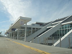
Lehigh Valley International Airport in Hanover Township in March 2014
Hannover Township Seal.png
Lehigh county - Hanover.png
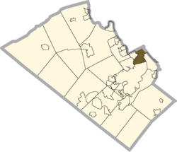
Location of Hanover Township in Lehigh County, Pennsylvania
USA Pennsylvania location map.svg
Red pog.svg
Hanover Township
Location in Pennsylvania
Usa edcp location map.svg
Red pog.svg
Hanover Township
Location in the United States
Coordinates: 40°38′30″N75°27′29″W / 40.64167°N 75.45806°W / 40.64167; -75.45806
Country Flag of the United States.svg  United States
State Flag of Pennsylvania.svg  Pennsylvania
County Lehigh
Area
[1]
   Township 4.24 sq mi (10.97 km2)
  Land4.21 sq mi (10.89 km2)
  Water0.03 sq mi (0.07 km2)
Elevation
377 ft (115 m)
Population
 (2010) [2]
   Township 1,571
  Estimate 
(2016) [3]
1,588
  Density377.56/sq mi (145.78/km2)
   Metro
865,310 (US: 68th)
Time zone UTC-5 (EST)
  Summer (DST) UTC-4 (EDT)
ZIP code
18109
Area code(s) 610
FIPS code 42-077-32400
Primary airport Lehigh Valley International Airport
Major hospital Lehigh Valley Hospital–Cedar Crest
School district Catasauqua Area
Website www.hanleco.org

Hanover Township is a township in Lehigh County, Pennsylvania, United States. As of the 2010 census, the township had a population of 1,571. [2] It is a suburb of Allentown and Bethlehem and part of the Lehigh Valley metropolitan area, which had a population of 861,899 and was the 68th-most populous metropolitan area in the U.S. as of the 2020 census.

Contents

Hanover Township is home of Lehigh Valley International Airport, the fourth-largest airport in Pennsylvania, with 851,000 passengers annually as of 2020.

Geography

According to the U.S. Census Bureau, the township has a total area of 4.2 square miles (11 km2), of which 0.03 square miles (0.08 km2), or 0.71%, are water. [1] The Lehigh River drains it and separates it from Whitehall Township.

Neighboring municipalities

Transportation

Roads and highways

US 22 East in Hanover Township 2022-09-26 10 24 03 View east along U.S. Route 22 (Lehigh Valley Thruway) from the overpass for Pennsylvania State Route 987 (Airport Road) in Hanover Township, Lehigh County, Pennsylvania.jpg
US 22 East in Hanover Township

As of 2022, there were 17.31 miles (27.86 km) of public roads in Hanover Township, of which 7.33 miles (11.80 km) were maintained by the Pennsylvania Department of Transportation (PennDOT) and 9.98 miles (16.06 km) were maintained by the township. [4]

U.S. Route 22 crosses the township east-to-west and interchanges in the township with Airport Road, which extends northeast toward Bath as Pennsylvania Route 987 and south into Allentown. Other local roads of note include Catasauqua Road, Dauphin Street, Irving Street, Pennsylvania Avenue, Postal Road, Race Street, and Schoenersville Road (pronounced "SHAY-nerz-vil.") The latter two roads intersect Route 987 in the village of Schoenersville on the border with Northampton County.

Lehigh Valley International Airport

Lehigh Valley International Airport is located in Hanover Township. It is the fourth most heavily trafficked airport in Pennsylvania with 851,000 passengers annually as of 2020.

Climate

The township has a hot-summer humid continental climate (Dfa) and the hardiness zone is 6b.

MonthJanFebMarAprMayJunJulAugSepOctNovDecYear
Record high °F (°C)72
(22)
81
(27)
87
(31)
93
(34)
97
(36)
100
(38)
105
(41)
100
(38)
99
(37)
93
(34)
81
(27)
72
(22)
105
(41)
Mean maximum °F (°C)60.2
(15.7)
60.6
(15.9)
70.6
(21.4)
83.2
(28.4)
89.3
(31.8)
92.6
(33.7)
94.8
(34.9)
92.8
(33.8)
89.2
(31.8)
80.4
(26.9)
70.9
(21.6)
61.7
(16.5)
95.9
(35.5)
Mean daily maximum °F (°C)38.4
(3.6)
41.6
(5.3)
50.8
(10.4)
63.4
(17.4)
73.5
(23.1)
81.9
(27.7)
86.4
(30.2)
84.3
(29.1)
77.4
(25.2)
65.5
(18.6)
53.8
(12.1)
43.1
(6.2)
63.3
(17.4)
Daily mean °F (°C)30.1
(−1.1)
32.4
(0.2)
40.7
(4.8)
51.8
(11.0)
62.0
(16.7)
70.9
(21.6)
75.6
(24.2)
73.6
(23.1)
66.3
(19.1)
54.6
(12.6)
43.9
(6.6)
35.0
(1.7)
53.1
(11.7)
Mean daily minimum °F (°C)21.8
(−5.7)
23.2
(−4.9)
30.5
(−0.8)
40.3
(4.6)
50.6
(10.3)
59.9
(15.5)
64.7
(18.2)
62.8
(17.1)
55.2
(12.9)
43.8
(6.6)
34.1
(1.2)
26.8
(−2.9)
42.8
(6.0)
Mean minimum °F (°C)4.2
(−15.4)
5.9
(−14.5)
14.1
(−9.9)
25.9
(−3.4)
35.3
(1.8)
46.5
(8.1)
53.7
(12.1)
51.1
(10.6)
39.9
(4.4)
28.7
(−1.8)
19.1
(−7.2)
11.7
(−11.3)
1.8
(−16.8)
Record low °F (°C)−15
(−26)
−12
(−24)
−5
(−21)
12
(−11)
28
(−2)
39
(4)
46
(8)
41
(5)
30
(−1)
21
(−6)
3
(−16)
−8
(−22)
−15
(−26)
Average precipitation inches (mm)3.30
(84)
2.77
(70)
3.63
(92)
3.67
(93)
3.65
(93)
4.40
(112)
5.30
(135)
4.56
(116)
4.84
(123)
4.14
(105)
3.24
(82)
3.86
(98)
47.36
(1,203)
Average snowfall inches (cm)9.8
(25)
10.8
(27)
6.3
(16)
0.5
(1.3)
0.0
(0.0)
0.0
(0.0)
0.0
(0.0)
0.0
(0.0)
0.0
(0.0)
0.2
(0.51)
0.9
(2.3)
4.6
(12)
33.1
(84)
Average precipitation days (≥ 0.01 in)11.410.110.911.812.411.411.010.29.69.98.911.5129.1
Average snowy days (≥ 0.1 in)5.14.32.60.30.00.00.00.00.00.00.52.915.7
Average relative humidity (%)70666261666870727472707169
Percent possible sunshine 43485347546357565453454251
Source: NOAA (relative humidity 1981–2010) [5] [6] [7]

Demographics

Historical population
CensusPop.Note
2000 1,913
2010 1,571−17.9%
2016 (est.)1,588 [3] 1.1%
U.S. Decennial Census [8]

As of the census [9] of 2000, there were 1,913 people, 892 households, and 498 families residing in the township. The population density was 454.6 inhabitants per square mile (175.5/km2). There were 937 housing units at an average density of 222.7 per square mile (86.0/km2). The racial makeup of the township was 86.15% White, 5.54% African American, 0.05% Native American, 4.70% Asian, 1.99% from other races, and 1.57% from two or more races. Hispanic or Latino of any race were 6.12% of the population.

There were 892 households, out of which 20.6% had children under the age of 18 living with them, 41.1% were married couples living together, 11.3% had a female householder with no husband present, and 44.1% were non-families. 34.1% of all households were made up of individuals, and 8.9% had someone living alone who was 65 years of age or older. The average household size was 2.14 and the average family size was 2.77.

In the township, the population was spread out, with 18.3% under the age of 18, 8.7% from 18 to 24, 32.9% from 25 to 44, 26.2% from 45 to 64, and 13.8% who were 65 years of age or older. The median age was 38 years. For every 100 females, there were 96.4 males. For every 100 females age 18 and over, there were 93.8 males. The median income for a household in the township was $35,061, and the median income for a family was $41,680. Males had a median income of $31,848 versus $27,014 for females. The per capita income for the township was $20,265. About 4.0% of families and 5.6% of the population were below the poverty line, including 6.3% of those under age 18 and 8.5% of those age 65 or over.

Public education

The township is served by the Catasauqua Area School District. High school students in grades nine through 12 attend Catasauqua High School in Northampton.

Notes

  1. Mean monthly maxima and minima (i.e. the highest and lowest temperature readings during an entire month or year) calculated based on data at said location from 1981 to 2010.
  2. Official records for Allentown were kept at Allentown Gas Company from March 1922 to December 1943, and at Lehigh Valley Int'l since January 1944. For more information, see ThreadEx.

Related Research Articles

<span class="mw-page-title-main">Lehigh County, Pennsylvania</span> County in Pennsylvania, United States

Lehigh County is a county in the Commonwealth of Pennsylvania. As of the 2020 census, the county's population was 374,557. Its county seat is Allentown, the state's third-largest city after Philadelphia and Pittsburgh.

<span class="mw-page-title-main">Catasauqua, Pennsylvania</span> Borough in Pennsylvania, United States

Catasauqua, referred to colloquially as Catty, is a borough in Lehigh County, Pennsylvania, United States. Catasauqua's population was 6,518 at the 2020 census. It is a suburb of Allentown in the Lehigh Valley, which had a population of 861,899 and was the 68th-most populous metropolitan area in the U.S. as of the 2020 census.

<span class="mw-page-title-main">Fullerton, Pennsylvania</span> Census-designated place in Pennsylvania, United States

Fullerton is an unincorporated area and census-designated place (CDP) in Whitehall Township in Lehigh County, Pennsylvania. The population of Fullerton was 16,588 as of the 2020 census.

<span class="mw-page-title-main">Hokendauqua, Pennsylvania</span> Census-designated place in Pennsylvania, United States

Hokendauqua is an unincorporated community and census-designated place (CDP) in Whitehall Township in Lehigh County, Pennsylvania, United States. The population of Hokendauqua was 3,340 as of the 2020 census. Hokendauqua is a suburb of Allentown, Pennsylvania in the Lehigh Valley metropolitan area, which had a population of 861,899 and was the 68th-most populous metropolitan area in the U.S. as of the 2020 census.

<span class="mw-page-title-main">North Whitehall Township, Pennsylvania</span> Township in Pennsylvania, United States

North Whitehall Township is a township in Lehigh County, Pennsylvania, United States. The population of North Whitehall Township was 15,655 at the 2020 census. It is a suburb of Allentown in the Lehigh Valley, which had a population of 861,899 and was the 68th-most populous metropolitan area in the U.S. as of the 2020 census.

<span class="mw-page-title-main">Salisbury Township, Lehigh County, Pennsylvania</span> Township in Pennsylvania, United States

Salisbury Township is a township in Lehigh County, Pennsylvania, United States. The township's population was 13,621 at the 2020 census. The township borders Allentown, Pennsylvania's third-largest city, Bethlehem, and Emmaus, in the Lehigh Valley, which had a population of 861,899 and was the 68th-most populous metropolitan area in the U.S. as of the 2020 census.

<span class="mw-page-title-main">Upper Macungie Township, Pennsylvania</span> Township in Pennsylvania, United States

Upper Macungie Township is a township in Lehigh County, Pennsylvania, United States. The population of Upper Macungie Township was 26,377 as of the 2020 U.S. census, making it the fourth-fastest growing municipality of any category in Pennsylvania in terms of total population growth between 2010 and 2020.

<span class="mw-page-title-main">Upper Milford Township, Pennsylvania</span> Township in Pennsylvania, United States

Upper Milford Township is a township in Lehigh County, Pennsylvania, United States. The township's population was 7,292 at the 2010 census. Upper Milford Township is a rural area southwest of Allentown in the Lehigh Valley, which had a population of 861,899 and was the 68th-most populous metropolitan area in the U.S. as of the 2020 census.

<span class="mw-page-title-main">Upper Saucon Township, Pennsylvania</span> Township in Pennsylvania, United States

Upper Saucon Township is a township in Lehigh County, Pennsylvania, United States. It is part of the Lehigh Valley metropolitan area, which had a population of 861,899 and was the 68th-most populous metropolitan area in the U.S. as of the 2020 census. The township had a population of 16,973 as of the 2020 census.

<span class="mw-page-title-main">Washington Township, Lehigh County, Pennsylvania</span> Township in Pennsylvania, United States

Washington Township is a township in Lehigh County, Pennsylvania, United States. The population of Washington Township was 6,624 at the 2010 census. It is a suburb of Allentown in the Lehigh Valley, which had a population of 861,899 and was the 68th-most populous metropolitan area in the U.S. as of the 2020 census.

<span class="mw-page-title-main">Whitehall Township, Pennsylvania</span> Township in Pennsylvania, United States

Whitehall Township is a township with home rule status in Lehigh County, Pennsylvania, United States. The township's population was 26,738 as of the 2010 census.

<span class="mw-page-title-main">Allen Township, Northampton County, Pennsylvania</span> Township in Pennsylvania, United States

Allen Township is a township in Northampton County, Pennsylvania, United States. The population of Allen Township was 4,269 at the 2010 census. Allen Township is part of the Lehigh Valley metropolitan area, which had a population of 861,899 and was the 68th-most populous metropolitan area in the U.S. as of the 2020 census.

<span class="mw-page-title-main">Bethlehem Township, Pennsylvania</span> Place in Pennsylvania, United States

Bethlehem Township is a township in Northampton County, Pennsylvania, United States. The population of Bethlehem Township was 23,730 at the 2010 census. It is a suburb of Bethlehem and is part of the Lehigh Valley metropolitan statistical area, which had a population of 861,899 and was the 68th-most populous metropolitan area in the U.S. as of the 2020 census.

<span class="mw-page-title-main">East Allen Township, Pennsylvania</span> Place in Pennsylvania, United States

East Allen Township is a township in Northampton County, Pennsylvania, United States. The population of East Allen Township was 4,903 at the 2010 census. East Allen is part of the Lehigh Valley metropolitan area, which had a population of 861,899 and was the 68th-most populous metropolitan area in the U.S. as of the 2020 census.

<span class="mw-page-title-main">Forks Township, Northampton County, Pennsylvania</span> Place in Pennsylvania, United States

Forks Township is a township in Northampton County, Pennsylvania, United States. The population of Forks Township was 14,721 as of the 2010 census. It is part of the Lehigh Valley metropolitan area, which had a population of 861,899 and was the 68th-most populous metropolitan area in the U.S. as of the 2020 census. The township is home to the global headquarters of Crayola, founded in 1885, a global arts supply company and the world's leading manufacturer of crayons.

<span class="mw-page-title-main">Hanover Township, Northampton County, Pennsylvania</span> Place in Pennsylvania, United States

Hanover Township is a township in Northampton County, Pennsylvania, United States. The population of Hanover Township was 10,866 at the 2010 census.

<span class="mw-page-title-main">Lehigh Township, Northampton County, Pennsylvania</span> Place in Pennsylvania, United States

Lehigh Township is a township in Northampton County, Pennsylvania, United States. The population of Lehigh Township was 10,526 as of the 2010 census. It is part of the Lehigh Valley metropolitan area, which had a population of 861,899 and was the 68th-most populous metropolitan area in the U.S. as of the 2020 census.

<span class="mw-page-title-main">Moore Township, Pennsylvania</span> Place in Pennsylvania, United States

Moore Township is a township in Northampton County, Pennsylvania, United States. The population of Moore Township was 9,198 at the 2010 census. The township is located in the Lehigh Valley, which had a population of 861,899 and was the 68th-most populous metropolitan area in the U.S. as of the 2020 census.

<span class="mw-page-title-main">North Catasauqua, Pennsylvania</span> Place in Pennsylvania, United States

North Catasauqua is a borough in Northampton County, Pennsylvania, United States. The borough was founded in 1907. The population of North Catasauqua was 2,971 at the 2020 census. The borough is part of the Lehigh Valley metropolitan area, which had a population of 861,899 and was the 68th-most populous metropolitan area in the U.S. as of the 2020 census.

<span class="mw-page-title-main">Palmer Township, Pennsylvania</span> Second Class Township in Pennsylvania, United States

Palmer Township is a township in Northampton County, Pennsylvania, United States. The population of Palmer Township was 22,317 at the 2020 census. It is the eight-largest municipality in the Lehigh Valley metropolitan area, which had a population of 861,899 and was the 68th-most populous metropolitan area in the U.S. as of the 2020 census.

References

  1. 1 2 "2016 U.S. Gazetteer Files". United States Census Bureau. Retrieved August 14, 2017.
  2. 1 2 "Total Population: 2010 Census DEC Summary File 1 (P1), Hanover township, Lehigh County, Pennsylvania". data.census.gov. U.S. Census Bureau. Retrieved October 19, 2020.
  3. 1 2 "Population and Housing Unit Estimates" . Retrieved June 9, 2017.
  4. "Hanover Township map" (PDF). PennDOT. Retrieved March 17, 2023.
  5. "NowData – NOAA Online Weather Data". National Oceanic and Atmospheric Administration. Retrieved August 8, 2021.
  6. "Station: Allentown INTL AP, PA". U.S. Climate Normals 2020: U.S. Monthly Climate Normals (1991–2020). National Oceanic and Atmospheric Administration. Retrieved August 8, 2021.
  7. "Local Climatological Data Annual Summary with Comparative Data for Allentown, Pennsylvania (KABE)" (PDF). National Oceanic and Atmospheric Administration. Archived from the original (PDF) on August 9, 2021. Retrieved August 8, 2021.
  8. "Census of Population and Housing". Census.gov. Retrieved June 4, 2016.
  9. "U.S. Census website". United States Census Bureau . Retrieved January 31, 2008.