Northampton County | |
---|---|
Coordinates: 40°45′N75°19′W / 40.75°N 75.31°W | |
Country | United States |
State | Pennsylvania |
Founded | March 11, 1752 |
Named for | Northamptonshire, England |
Seat | Easton |
Largest city | Bethlehem |
Area | |
• Total | 377 sq mi (980 km2) |
• Land | 370 sq mi (1,000 km2) |
• Water | 7.7 sq mi (20 km2) 2.0% |
Population (2020) | |
• Total | 312,951 |
• Density | 830/sq mi (320/km2) |
Time zone | UTC−5 (Eastern) |
• Summer (DST) | UTC−4 (EDT) |
Congressional district | 7th |
Website | www |
Northampton County is a county in the Commonwealth of Pennsylvania, United States. As of the 2020 census, the population was 312,951. [1] Its county seat is Easton. [2] The county was formed in 1752 from parts of Bucks County. Its namesake was the county of Northamptonshire in England, and the county seat of Easton was named for Easton Neston, a country house in Northamptonshire.
Northampton County and Lehigh County to its west combine to form the eastern Pennsylvania region known as the Lehigh Valley; Lehigh County, with a population of 374,557 as of the 2020 U.S. census, is the more highly populated of the two counties. Both counties are part of the Philadelphia media market, the fourth-largest in the nation.
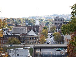
Northampton County has historically been a national leader in heavy manufacturing, especially of cement, steel, and other industrial products. Atlas Portland Cement Company, the world's largest cement manufacturer from 1895 until 1982, was based in Northampton in the county. [3] Bethlehem Steel, the world's second-largest manufacturer of steel for most of the 20th century, was based in Bethlehem, the county's most populous city, prior to its dissolution in 2003.
Northampton County borders Carbon County and the Poconos to its north, Lehigh County to its west, Bucks County to its south, and the Delaware River and New Jersey to its east. The Lehigh River, a 109-mile-long (175 km) tributary of the Delaware River, flows through the county.
According to the U.S. Census Bureau, the county has a total area of 377 square miles (980 km2), of which 370 square miles (960 km2) is land and 7.7 square miles (20 km2) (2.0%) is water. [4] The climate is humid continental (mostly Dfa with a little Dfb in higher northern areas) and the hardiness zone is 7a except in the northern iier where it is 6b. Average monthly temperatures in downtown Bethlehem average from 29.1 °F in January to 74.1 °F in July, while in Wind Gap they average from 27.0 °F in January to 71.7 °F in July. [5] Notably, the Lehigh and Delaware rivers flow through Northampton County. To its north is the Kittatinny Ridge, in the south are the South Mountains (part of the piedmont) and to its east are the Paxinosa Mountains.
Census | Pop. | Note | %± |
---|---|---|---|
1790 | 24,220 | — | |
1800 | 30,062 | 24.1% | |
1810 | 38,145 | 26.9% | |
1820 | 31,765 | −16.7% | |
1830 | 39,482 | 24.3% | |
1840 | 40,996 | 3.8% | |
1850 | 40,235 | −1.9% | |
1860 | 47,904 | 19.1% | |
1870 | 61,432 | 28.2% | |
1880 | 70,312 | 14.5% | |
1890 | 84,220 | 19.8% | |
1900 | 99,687 | 18.4% | |
1910 | 127,667 | 28.1% | |
1920 | 153,506 | 20.2% | |
1930 | 169,304 | 10.3% | |
1940 | 168,959 | −0.2% | |
1950 | 185,243 | 9.6% | |
1960 | 201,412 | 8.7% | |
1970 | 214,368 | 6.4% | |
1980 | 225,418 | 5.2% | |
1990 | 247,105 | 9.6% | |
2000 | 267,066 | 8.1% | |
2010 | 297,735 | 11.5% | |
2020 | 312,951 | 5.1% | |
U.S. Decennial Census [6] 1790-1960 [7] 1900-1990 [8] 1990-2000 [9] 2010-2019 [1] |
As of the 2020 census, the county's population was 312,951, reflecting growth of 5.1% over 2010. [1] As of the 2010 census, the county was 81.0% White Non-Hispanic, 5.0% Black or African American, 0.2% Native American or Alaskan Native, 2.4% Asian, 0.0% Native Hawaiian, 2.2% were two or more races, and 3.8% were some other race. 10.5% of the population were of Hispanic or Latino ancestry.
Race | Num. | Perc. |
---|---|---|
White (NH) | 228,373 | 73% |
Black or African American (NH) | 17,429 | 5.6% |
Native American (NH) | 251 | 0.08% |
Asian (NH) | 9,892 | 3.2% |
Pacific Islander (NH) | 75 | 0.02% |
Other/Mixed (NH) | 12,334 | 4% |
Hispanic or Latino | 44,597 | 14.25% |
Northampton is one of the seven counties in Pennsylvania which has adopted a home rule charter. Voters elect a county executive, a nine-person county council, a county controller, and a county district attorney. The executive, controller, district attorney, and five of the nine council members are elected at large by all voters in the county. The other four members of the county council are elected from single-member districts, which they represent. This weighted structure of county government favors the majority of voters. The county's row officers are nominated by the county executive and approved by county council.
Year | Republican | Democratic | Third party(ies) | |||
---|---|---|---|---|---|---|
No. | % | No. | % | No. | % | |
2024 | 89,817 | 50.40% | 86,655 | 48.62% | 1,743 | 0.98% |
2020 | 83,854 | 48.92% | 85,087 | 49.64% | 2,458 | 1.43% |
2016 | 71,736 | 49.62% | 66,272 | 45.84% | 6,558 | 4.54% |
2012 | 61,446 | 46.89% | 67,606 | 51.59% | 1,992 | 1.52% |
2008 | 58,551 | 43.07% | 75,255 | 55.35% | 2,148 | 1.58% |
2004 | 62,102 | 48.96% | 63,446 | 50.02% | 1,301 | 1.03% |
2000 | 47,396 | 45.27% | 53,097 | 50.72% | 4,197 | 4.01% |
1996 | 35,726 | 39.26% | 43,959 | 48.31% | 11,317 | 12.44% |
1992 | 34,429 | 35.30% | 42,203 | 43.27% | 20,893 | 21.42% |
1988 | 42,748 | 51.52% | 39,264 | 47.32% | 966 | 1.16% |
1984 | 44,648 | 53.49% | 37,979 | 45.50% | 840 | 1.01% |
1980 | 35,787 | 47.07% | 31,920 | 41.98% | 8,330 | 10.96% |
1976 | 32,926 | 42.78% | 42,514 | 55.24% | 1,521 | 1.98% |
1972 | 41,822 | 56.30% | 32,335 | 43.53% | 124 | 0.17% |
1968 | 32,033 | 41.00% | 42,554 | 54.47% | 3,543 | 4.53% |
1964 | 21,048 | 26.15% | 58,818 | 73.08% | 619 | 0.77% |
1960 | 40,683 | 49.43% | 41,552 | 50.48% | 71 | 0.09% |
1956 | 43,375 | 55.83% | 33,749 | 43.44% | 573 | 0.74% |
1952 | 39,131 | 50.99% | 36,993 | 48.21% | 614 | 0.80% |
1948 | 27,030 | 43.95% | 33,209 | 53.99% | 1,265 | 2.06% |
1944 | 26,643 | 44.76% | 32,584 | 54.75% | 292 | 0.49% |
1940 | 25,385 | 43.06% | 33,304 | 56.49% | 269 | 0.46% |
1936 | 22,827 | 37.34% | 36,871 | 60.31% | 1,438 | 2.35% |
1932 | 20,779 | 45.04% | 24,009 | 52.04% | 1,345 | 2.92% |
1928 | 37,403 | 71.14% | 14,768 | 28.09% | 404 | 0.77% |
1924 | 20,459 | 58.42% | 11,459 | 32.72% | 3,104 | 8.86% |
1920 | 14,227 | 58.78% | 9,086 | 37.54% | 891 | 3.68% |
1916 | 9,610 | 44.37% | 11,000 | 50.78% | 1,050 | 4.85% |
1912 | 3,893 | 17.91% | 10,325 | 47.50% | 7,518 | 34.59% |
1908 | 10,857 | 46.91% | 11,365 | 49.10% | 923 | 3.99% |
1904 | 11,039 | 51.21% | 9,914 | 45.99% | 604 | 2.80% |
1900 | 9,849 | 45.14% | 11,412 | 52.31% | 556 | 2.55% |
1896 | 9,762 | 47.59% | 10,032 | 48.91% | 717 | 3.50% |
1892 | 6,892 | 39.21% | 10,320 | 58.71% | 367 | 2.09% |
1888 | 6,785 | 39.67% | 10,027 | 58.63% | 291 | 1.70% |
1884 | 6,327 | 39.44% | 9,491 | 59.16% | 224 | 1.40% |
1880 | 5,961 | 37.90% | 9,653 | 61.37% | 114 | 0.72% |
As of January 8, 2024, there were 219,719 registered voters in Northampton County
Northampton County is considered one of Pennsylvania's "swing counties," with statewide winners carrying it in most cases. [12] [13] As of 2024, the last presidential election where Northampton County did not back the statewide winner was in 1948.
In November 2019, municipal elections were in Pennsylvania in November 2019, and the county's result tabulations were plagued with problems caused by newly purchased voting machines, known as ExpressVoteXL, which were manufactured and sold to the county by Election Systems & Software (ES&S), an Omaha, Nebraska-based company, as representing a luxury one-stop voting system.
According to The New York Times and other media, a few minutes after polls closed in the county in 2019, panic began to spread through the county's election offices as it became evident that vote totals in one judge's race showed one candidate, Abe Kassis, a Democrat, had received just 164 votes out of 55,000 ballots across more than the 100 precincts in the county; Some precinct machines reported zero votes for him. [14]
The ES&S voting system, which is used in other Pennsylvania jurisdictions, features a touch screen with a paper ballot backup. County officials ultimately calculated results by counting paper ballots, which showed Kassis actually won the election by 1,054 votes, according to unofficial results that were announced on November 6. The election results were later certified following a canvass and audit, and no challenges to the results were filed. [15]
On November 7, 2023, ExpressVoteXL machines again malfunctioned in calculating votes for Superior Court of Pennsylvania judges with the machines switching "yes" and "no" votes on the summary display of votes on whether the judges should be retained. The county's director of administration, Charles Dertinger, attributed the problem to the summary display and not the actual ballots. [16]
Name | Party | Term start | Term end |
---|---|---|---|
Glenn F. Reibman | Democratic | 1998 | 2006 |
John Stoffa | Democratic | 2006 | 2014 |
John Brown | Republican | 2014 | 2018 |
Lamont McClure | Democratic | 2018 | Incumbent |
Air transport to and from Northampton County is available through Lehigh Valley International Airport ( IATA : ABE, ICAO : KABE) in Hanover Township, which is located approximately 4 miles (6.4 km) northwest of Bethlehem and 11 miles (18 km) west-southwest of Easton.
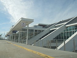
Public bus service in Northampton County is available through LANta. A shuttle bus service called the Bethlehem Loop provides public transportation services in Bethlehem. NJ Transit provides service from Easton's Centre Square to the Phillipsburg area.
Northampton County was once served only by the 215 area code from 1947 (when the North American Numbering Plan of the Bell System went into effect) until 1994. With the county's growing population, however, Northampton County was afforded area code 610 in 1994. Today, Northampton County is covered by 610 except for the Portland exchange which uses 570. An overlay area code, 484, was added to the 610 service area in 1999. [18] A plan to introduce area code 835 as an additional overlay was rescinded in 2001. [19]
There are two Pennsylvania state parks in Northampton County:
The following cities, boroughs, and townships are located in Northampton County:
Census-designated places are unincorporated communities designated by the U.S. Census Bureau for the purposes of compiling demographic data. They are not actual jurisdictions under Pennsylvania law.
The population ranking of the following table is based on the 2010 census of Northampton County. [20]
†county seat
Rank | City/borough/township/etc. | Municipal type | Population (2010 Census) |
---|---|---|---|
1 | Bethlehem (partially in Lehigh County ) | City | 74,982 |
2 | † Easton | City | 26,800 |
3 | Bethlehem Township | Township | 23,730 |
4 | Palmer Township | Township | 20,691 |
5 | Forks Township | Township | 14,721 |
6 | Hanover Township | Township | 10,866 |
7 | Lower Saucon Township | Township | 10,772 |
8 | Lehigh Township | Township | 10,527 |
9 | Northampton | Borough | 9,926 |
10 | Moore Township | Township | 9,198 |
11 | Bushkill Township | Township | 8,178 |
12 | Wilson | Borough | 7,896 |
13 | Middletown | CDP | 7,441 |
14 | Upper Mount Bethel Township | Township | 6,706 |
15 | Upper Nazareth Township | Township | 6,231 |
16 | Plainfield Township | Township | 6,138 |
17 | Hellertown | Borough | 5,898 |
18 | Williams Township | Township | 5,884 |
19 | Nazareth | Borough | 5,746 |
20 | Lower Nazareth Township | Township | 5,674 |
21 | Bangor | Borough | 5,273 |
22 | Washington Township | Township | 5,122 |
23 | East Allen Township | Township | 4,930 |
24 | Allen Township | Township | 4,269 |
25 | Palmer Heights | CDP | 3,762 |
26 | Pen Argyl | Borough | 3,595 |
27 | Eastlawn Gardens | CDP | 3,307 |
28 | Lower Mount Bethel Township | Township | 3,101 |
29 | North Catasauqua | Borough | 2,849 |
30 | Wind Gap | Borough | 2,720 |
31 | Bath | Borough | 2,693 |
32 | Freemansburg | Borough | 2,636 |
33 | Old Orchard | CDP | 2,434 |
34 | Walnutport | Borough | 2,070 |
35 | Cherryville | CDP | 1,580 |
36 | Roseto | Borough | 1,567 |
37 | Belfast | CDP | 1,257 |
38 | West Easton | Borough | 1,257 |
39 | Tatamy | Borough | 1,203 |
40 | East Bangor | Borough | 1,172 |
41 | Raubsville | CDP | 1,088 |
42 | Stockertown | Borough | 927 |
43 | Martins Creek | CDP | 631 |
44 | Ackermanville | CDP | 610 |
45 | Portland | Borough | 519 |
46 | Glendon | Borough | 440 |
47 | Chapman | Borough | 199 |
Lehigh County is a county in the Commonwealth of Pennsylvania. As of the 2020 census, the county's population was 374,557. Its county seat is Allentown, the state's third-largest city after Philadelphia and Pittsburgh.
Upper Saucon Township is a township in Lehigh County, Pennsylvania, United States. It is part of the Lehigh Valley metropolitan area, which had a population of 861,899 and was the 68th-most populous metropolitan area in the U.S. as of the 2020 census. The township had a population of 16,973 as of the 2020 census.
Bethlehem Township is a township in Northampton County, Pennsylvania, United States. The population of Bethlehem Township was 25861 at the 2020 census. It is a suburb of Bethlehem and is part of the Lehigh Valley metropolitan statistical area, which had a population of 861,899 and was the 68th-most populous metropolitan area in the U.S. as of the 2020 census.
Easton is a city in and the county seat of Northampton County, Pennsylvania, United States. The city's population was 28,127 as of the 2020 census. Easton is located at the confluence of the Lehigh River, a 109-mile-long (175 km) river that joins the Delaware River in Easton and serves as the city's eastern geographic boundary with Phillipsburg, New Jersey.
Hellertown is a borough in Northampton County, Pennsylvania. Its population was 6,131 at the 2020 census. Hellertown is part of the Lehigh Valley metropolitan area, which had a population of 861,899 and was the 68th-most populous metropolitan area in the U.S. as of 2020.
Moore Township is a township in Northampton County, Pennsylvania, United States. The population of Moore Township was 9,198 at the 2010 census. The township is located in the Lehigh Valley, which had a population of 861,899 and was the 68th-most populous metropolitan area in the U.S. as of the 2020 census.
Palmer Township is a township in Northampton County, Pennsylvania, United States. The population of Palmer Township was 22,317 at the 2020 census. It is the eight-largest municipality in the Lehigh Valley metropolitan area, which had a population of 861,899 and was the 68th-most populous metropolitan area in the U.S. as of the 2020 census.
Bethlehem is a city in Northampton and Lehigh counties in the Lehigh Valley region of eastern Pennsylvania, United States. As of the 2020 census, Bethlehem had a total population of 75,781, making it the second-largest city in the Lehigh Valley after Allentown and the seventh-largest city in the state. Among its total population as of 2020, 55,639 were in Northampton County and 19,343 were in Lehigh County. The city is located along the Lehigh River, a 109-mile-long (175 km) tributary of the Delaware River.
The following is an alphabetical list of articles on people, places, and things related to Pennsylvania in the United States.
The Lehigh Valley is a geographic and metropolitan region formed by the Lehigh River in Lehigh and Northampton counties in eastern Pennsylvania. It is a component valley of the Great Appalachian Valley bounded to its north by Blue Mountain, to its south by South Mountain, to its west by Lebanon Valley, and to its east by the Delaware River and Warren County, New Jersey. The Lehigh Valley is about 40 miles (64 km) long and 20 miles (32 km) wide. The Lehigh Valley's largest city is Allentown, the third-largest city in Pennsylvania and the county seat of Lehigh County, with a population of 125,845 residents as of the 2020 census.
Area codes 610, 484, and 835 are telephone area codes in the North American Numbering Plan (NANP) for the eastern and southeastern regions of Pennsylvania. The numbering plan area (NPA) includes regions to the west of Philadelphia and the cities Allentown, Bethlehem, and Reading. It includes much of the Delaware Valley, including almost all of Delaware County, most of the Philadelphia Main Line, and all of the Lehigh Valley.
Minsi Trails Council is a council of the Boy Scouts of America that serves Scouts in the Lehigh Valley and the Pocono Mountains regions of eastern Pennsylvania and western New Jersey. In Pennsylvania, the council serves five counties: Lehigh, Northampton, Monroe, Carbon, and Luzerne. In New Jersey, it serves Warren County.
Pennsylvania Route 378 (PA 378) is a state highway in Lehigh and Northampton counties in the Lehigh Valley region of the U.S. state of Pennsylvania. The southern terminus is at PA 309 in Center Valley. Its northern terminus is at U.S. Route 22 (US 22) in Bethlehem. The route heads north from PA 309 as a two-lane undivided road through Upper Saucon Township and Lower Saucon Township before crossing South Mountain into Bethlehem. Here, PA 378 follows city streets through Bethlehem's South Side, intersecting the northern terminus of PA 412. The route becomes a four-lane freeway and crosses the Lehigh River before continuing north to US 22. PA 378 is the only highway from US 22 to Center City Bethlehem, and a quick route for visitors traveling to the Wind Creek Bethlehem casino resort on the city's South Side.
Pennsylvania's 7th congressional district includes all of Carbon, Lehigh, and Northampton Counties, and parts of Monroe County. The has been represented by Republican Ryan Mackenzie since 2025.
The Lehigh Valley Interscholastic Athletic Conference, known informally as the Lehigh Valley Conference or LVC, was an athletic conference consisting of 12 of the largest high schools from Lehigh and Northampton counties in the Lehigh Valley region of Pennsylvania. It was part of District XI of the Pennsylvania Interscholastic Athletic Association (PIAA). In 2014, its teams were mostly assimilated into the Eastern Pennsylvania Conference, an even larger 18-team league of the largest high schools in the Lehigh Valley and Pocono Mountains regions of eastern and northeastern Pennsylvania.
Pennsylvania State Senate District 18 includes parts of Lehigh and Northampton counties in the Lehigh Valley region of eastern Pennsylvania. It is currently represented by Democrat Lisa Boscola.
The Colonial League is an athletic conference consisting of 14 high schools mostly from the Lehigh Valley portion of eastern Pennsylvania. It is part of District XI of the Pennsylvania Interscholastic Athletic Association. The Colonial League is designed for mid and small-size schools in the Lehigh Valley. The largest 18 schools in the Lehigh Valley and Pocono region compete in the Eastern Pennsylvania Conference, one of the premiere athletic divisions in the nation.
District 11 of the Pennsylvania Interscholastic Athletic Association (PIAA) is an interscholastic athletic association in eastern Pennsylvania.
Ackermanville is a census-designated place located on PA Route 191 in Washington Township, Northampton County, Pennsylvania, United States. As of the 2022 American Community Survey, the village's population was 280. Ackermanville is part of the Lehigh Valley metropolitan area, which had a population of 861,899 and was the 68th-most populous metropolitan area in the U.S. as of the 2020 census. It was named for the Ackerman family.
The Slate Belt is a geographic region in Northampton County, Pennsylvania that is typically described as including Bangor, Wind Gap, Pen Argyl, and Portland. The region is named for the historical prevalence of slate quarrying in the area.