Berks County, Pennsylvania

Last updated

Berks County
View of Reading area from Pagoda.jpg
Reading, the largest city in the county and fourth-largest in Pennsylvania, in October 2010
Flag of Berks County, Pennsylvania.svg
Berks County Seal.png
Map of Pennsylvania highlighting Berks County.svg
Location within the U.S. state of Pennsylvania
Pennsylvania in United States.svg
Pennsylvania's location within the U.S.
Coordinates: 40°25′N75°56′W / 40.42°N 75.93°W / 40.42; -75.93
CountryFlag of the United States.svg United States
StateFlag of Pennsylvania.svg  Pennsylvania
FoundedMarch 11, 1752
Named for Berkshire
Seat Reading
Largest cityReading
Area
  Total866 sq mi (2,240 km2)
  Land857 sq mi (2,220 km2)
  Water9.2 sq mi (24 km2)  1.1%
Population
 (2020)
  Total428,849
  Density495/sq mi (191/km2)
Time zone UTC−5 (Eastern)
  Summer (DST) UTC−4 (EDT)
Congressional districts 4th, 6th, 9th
Website www.berkspa.gov
DesignatedMay 12, 1982 [1]

Berks County (Pennsylvania German: Barricks Kaundi) is a county in the Commonwealth of Pennsylvania. As of the 2020 census, the county's population was 428,849. [2] The county seat is Reading, the fourth-most populous city in the state. [3]

Contents

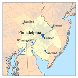
The county borders Lehigh County to its north and its east, Schuylkill County to its north, Lebanon and Lancaster counties to its west, and Chester County to its south. The county is approximately 26 miles (42 km) southwest of Allentown, the state's third-largest city, and 64 miles (103 km) northwest of Philadelphia, the state's largest city.

The Schuylkill River, a 135-mile-long (217 km) tributary of the Delaware River, flows through Berks County. The county is part of the Reading, PA metropolitan statistical area (MSA), which in turn is part of the Greater Philadelphia metropolitan area known as the Philadelphia-Reading-Camden, PA-NJ-DE-MD combined statistical area (CSA).

History

Reading developed during the 1740s when inhabitants of northern Lancaster County sent several petitions requesting that a separate county be established. With the help of German immigrant Conrad Weiser, the county was formed on March 11, 1752, from parts of Chester County, Lancaster County, and Philadelphia County. [4]

It was named after the English county in which William Penn's family home lay, Berkshire, which is often abbreviated to Berks. Berks County began much larger than it is today. The northwestern parts of the county went to the founding of Northumberland County in 1772 and Schuylkill County in 1811, when it reached its current size.

In 2005, Berks County was added to the Delaware Valley Planning Area due to a fast-growing population and close proximity to the other communities.

Geography

According to the U.S. Census Bureau, the county has a total area of 866 square miles (2,240 km2), 857 square miles (2,220 km2) of which is land and 9.2 square miles (24 km2) (1.1%) of which is water. [5]

Most of the county is drained by the Schuylkill River, but an area in the northeast is drained by the Lehigh River via the Little Lehigh Creek and areas are drained by the Susquehanna River via the Swatara Creek in the northwest and the Conestoga River, which starts in Berks County between Morgantown and Elverson in the county's extreme south. It has a humid continental climate (Dfa except for some Dfb on Blue Mountain at the northern boundary.) The hardiness zone is mostly 7a with 6b in some higher northern and eastern areas.

Adjacent counties

National protected area

State protected area

Major roads and highways

I-78/US Route 22 eastbound in Berks County 2022-08-16 16 20 06 View east along Interstate 78 and U.S. Route 22 (William Penn Highway) from the overpass for Power Drive in Upper Tulpehocken Township, Berks County, Pennsylvania.jpg
I-78/US Route 22 eastbound in Berks County

Demographics

Historical population
CensusPop.Note
1790 30,189
1800 32,4077.3%
1810 43,14633.1%
1820 46,2757.3%
1830 53,15214.9%
1840 64,56921.5%
1850 77,12919.5%
1860 93,81821.6%
1870 106,70113.7%
1880 122,59714.9%
1890 137,32712.0%
1900 159,61516.2%
1910 183,22214.8%
1920 200,8549.6%
1930 231,71715.4%
1940 241,8844.4%
1950 255,7405.7%
1960 275,4147.7%
1970 296,3827.6%
1980 312,5095.4%
1990 336,5237.7%
2000 373,63811.0%
2010 411,44210.1%
2020 428,8494.2%
U.S. Decennial Census [6]
1790–1960 [7] 1900–1990 [8]
1990–2000 [9] 2010–2019 [2]

As of the 2010 census, the county was 76.9% White non-Hispanic, 4.9% Black or African American, 0.3% Native American, 1.3% Asian, and 2.5% were two or more races. 16.4% of the population was of Hispanic or Latino ancestry. [10] Historically there is a large Pennsylvania Dutch population. It is known as part of Pennsylvania Dutch Country. More recently there is a large Puerto Rican population centered in the city of Reading. There were 411,442 people, 154,356 households, and 106,532 families residing in the county. The population density was 479 inhabitants per square mile (185/km2). There were 164,827 housing units at an average density of 191.9 per square mile (74.1/km2).

According to Muninet Guide's 2010 analysis, the median household income for Berks County is $54,105.

There were 154,356 households, out of which 33.1% had children under the age of 18 living with them, 52.1% were married couples living together, 12.0% had a female householder with no husband present, and 31.0% were non-families. 24.5% of all households were made up of individuals, and 10.3% had someone living alone who was 65 years of age or older. The average household size was 2.59 and the average family size was 3.08.

In the county, the population was spread out, with 23.9% under the age of 18, 9.9% from 18 to 24, 24.4% from 25 to 44, 27.3% from 45 to 64, and 14.5% who were 65 years of age or older. The median age was 39.1 years. For every 100 females there were 95.90 males. For every 100 females age 18 and over, there were 92.70 males.

Berks County is home to an Old Order Mennonite community consisting of about 160 families, located in the East Penn Valley near Kutztown and Fleetwood. [11] The Old Order Mennonites first bought land in the area in 1949. [12] In 2012, Old Order Mennonites bought two large farms in the Oley Valley. The Old Order Mennonites in the area belong to the Groffdale Conference Mennonite Church and use the horse and buggy as transportation. There are several farms in the area belonging to the Old Order Mennonite community and meetinghouses are located near Kutztown and Fleetwood. [13]

2020 census

Berks County Racial Composition [14]
RaceNum.Perc.
White (NH)291,25868%
Black or African American (NH)18,0874.22%
Native American (NH)4500.1%
Asian (NH)6,2251.5%
Pacific Islander (NH)610.01%
Other/Mixed (NH)13,2183.1%
Hispanic or Latino 99,55023.21%

Metropolitan and Combined Statistical Area

Location of Berks County in the Philadelphia-Reading-Camden, PA-NJ-DE-MD CSA Delawarevalleymap.png
Location of Berks County in the Philadelphia-Reading-Camden, PA-NJ-DE-MD CSA

The Office of Management and Budget [15] has designated Berks County as the Reading, PA Metropolitan Statistical Area (MSA). As of the 2010 U.S. census [16] the metropolitan area is the 10th-most populous in Pennsylvania and the 128th-most populous in the U.S. with a population of 413,491.

Berks County is part of the larger Philadelphia-Reading-Camden, PA-NJ-DE-MD Combined Statistical Area (CSA), the largest in Pennsylvania and eighth-most populous in the nation with a population of 7,067,807.

Government

Berks County Courthouse in Reading Berks County Courthouse (Berks County, Pennsylvania - September 2010).jpg
Berks County Courthouse in Reading

State Senate

State House of Representatives

U.S. House of Representatives

Politics

As of September 21, 2023 there were 253,186 registered voters in Berks County. [18]

As of 2023, the Republican Party maintained a total registration edge over Democrats in Berks County. At the top of the Pennsylvania ticket in November 2022, Berks County split its votes, supporting Democrat Josh Shapiro for governor and Republican Mehmet Oz for U.S. Senate.

United States presidential election results for Berks County, Pennsylvania [19]
Year Republican Democratic Third party
No.%No.%No.%
2020 109,92653.22%93,11645.08%3,5111.70%
2016 96,62652.49%78,43742.61%9,0224.90%
2012 84,70249.63%83,01148.64%2,9631.74%
2008 80,51344.60%97,04753.76%2,9511.63%
2004 87,12252.97%76,30946.39%1,0560.64%
2000 71,27352.68%59,15043.72%4,8743.60%
1996 56,28946.25%49,88740.99%15,54212.77%
1992 52,93940.29%46,03135.03%32,43724.68%
1988 70,15362.39%41,04036.50%1,2511.11%
1984 74,60565.94%37,84933.45%6910.61%
1980 60,57656.41%36,44933.94%10,3609.65%
1976 54,45250.63%50,99447.41%2,1071.96%
1972 66,17262.35%36,56334.45%3,3923.20%
1968 50,62346.48%49,87745.79%8,4247.73%
1964 36,72633.19%73,44466.38%4760.43%
1960 61,74354.78%50,57244.87%3910.35%
1956 57,25857.30%42,34942.38%3200.32%
1952 51,72052.42%45,87446.49%1,0741.09%
1948 35,60843.57%43,07552.71%3,0433.72%
1944 35,27443.33%43,88953.91%2,2472.76%
1940 32,11136.93%53,30161.31%1,5301.76%
1936 26,69930.23%56,90764.43%4,7215.34%
1932 27,07337.07%29,76340.76%16,18722.17%
1928 47,07364.03%18,96025.79%7,48110.18%
1924 28,18651.35%17,22031.37%9,48717.28%
1920 22,22147.69%18,36139.41%6,00912.90%
1916 11,93734.33%19,26755.41%3,56510.25%
1912 3,0328.77%16,43047.54%15,09843.69%
1908 13,64241.01%17,38152.25%2,2456.75%
1904 15,53946.28%16,35748.71%1,6835.01%
1900 13,95241.53%19,01356.60%6281.87%
1896 14,31843.28%18,09954.71%6652.01%
1892 10,07734.76%18,60264.16%3121.08%
1888 10,62636.65%18,10562.45%2610.90%
1884 9,58736.46%16,48462.68%2260.86%
1880 9,22534.99%16,95964.32%1810.69%

The first time since 1964 that a Democrat carried Berks in a Presidential election occurred in 2008, with Barack Obama receiving 53.9% of the vote to John McCain's 44.7%. The other three statewide winners (Rob McCord for treasurer, Jack Wagner for auditor general, and Tom Corbett for attorney general) also carried it. [20] While Republicans have controlled the commissioner majority most of the time and continue to control most county row offices, Democrats have become more competitive in Berks in recent years. In the 2012 Presidential election, Mitt Romney carried the county by approximately a one-percent margin, 49.6% to 48.6%, however, in 2016, Donald Trump carried Berks by a much larger margin of 52.9% to 42.7%. [21]

Chart of Voter Registration

   Republican (42.53%)
   Democratic (41.36%)
   Independent (11.78%)
   Other Parties (4.32%)

Education

Colleges and universities

Public school districts

Map of Berks County's public school districts Map of Berks County Pennsylvania School Districts.png
Map of Berks County's public school districts

School districts include: [22]

Private high schools

Technical and trade schools

Arts and culture

Reading Public Museum in Reading is an art, science, and history museum.

The Reading Buccaneers Drum and Bugle Corps are an all-age drum corps based in Berks County. Founded in 1957, the corps is a charter member Drum Corps Associates and an 11-time DCA World Champion.

Reading is home to Berks Opera Company, founded in 2007 as Berks Opera Workshop.

There are two Pennsylvania state parks and one natural area in Berks County.

There are two Pennsylvania Historic Sites in Berks County.

The Old Morlatton Village in Douglassville is maintained by the Historic Preservation Trust of Berks County. The village is composed of four historic structures: White Horse Inn, George Douglass Mansion, Bridge keeper's House, and the Mouns Jones House, constructed in 1716, which is the oldest recorded building in the county. [24]

West Reading in home to the annual Art on the Avenue, which reached its 25th year in 2019. [25]

Media

Berks County is home to several media outlets, including:

Communities

Map of Berks County with municipal labels showing cities and boroughs (in red), townships (in white), and census-designated places (in blue) Map of Berks County Pennsylvania With Municipal and Township Labels.png
Map of Berks County with municipal labels showing cities and boroughs (in red), townships (in white), and census-designated places (in blue)

Under Pennsylvania law, there are four types of incorporated municipalities: cities, boroughs, townships, and towns. The following cities, boroughs and townships are located in Berks County:

City

Boroughs

Townships

A farm in Windsor Township in January 2008 Farmstead in winter, Windsor Township, Berks County, Pennsylvania.jpg
A farm in Windsor Township in January 2008

Census-designated places

Census-designated places are geographical areas designated by the U.S. Census Bureau for the purposes of compiling demographic data. They are not actual jurisdictions under Pennsylvania law. Other unincorporated communities, such as villages, may be listed here as well.

Unincorporated communities

Population ranking

The population ranking of the following table is based on the 2010 census of Berks County. [16]

county seat

CDP=census designated population

RankCity/Town/etc.Municipal typePopulation (2010 Census)
1Reading City88,082
2 Wyomissing Borough10,461
3 Blandon CDP7,152
4 Shillington Borough5,273
5 Birdsboro Borough5,163
6 Kutztown Borough5,012
7 Whitfield CDP4,733
8 Hamburg Borough4,289
9 Lorane CDP4,236
10 Pennside CDP4,215
11 West Reading Borough4,212
12 Reiffton CDP4,178
13 Fleetwood Borough4,085
14 Boyertown Borough4,055
15 Sinking Spring Borough4,008
16 Laureldale Borough3,911
17 West Wyomissing CDP3,407
18 Amity Gardens CDP3,402
19 Jacksonwald CDP3,393
20 Riverview Park CDP3,380
21 Mount Penn Borough3,106
22 Mohnton Borough3,043
23 Kutztown University CDP2,918
24 Kenhorst Borough2,877
25 Womelsdorf Borough2,810
26 Flying Hills CDP2,568
27 Hyde Park CDP2,528
28 Wernersville Borough2,494
29 Topton Borough2,069
30 Robesonia Borough2,061
31 West Hamburg CDP1,979
32 Leesport Borough1,918
33 Temple CDP1,877
34 St. Lawrence Borough1,809
35 West Lawn CDP1,715
36 Fox Chase CDP1,622
37 Lincoln Park CDP1,615
38 Grill CDP1,468
39 South Temple CDP1,424
40 Muhlenberg Park CDP1,420
41 Shoemakersville Borough1,378
42 New Berlinville CDP1,368
43 Oley CDP1,282
44 Greenfields CDP1,170
45 Alleghenyville CDP1,134
46 Bally Borough1,090
47 Colony Park CDP1,076
48 Stony Creek Mills CDP1,045
49 Spring Ridge CDP1,003
50 Bernville Borough955
51 Bechtelsville Borough942
52 Hereford CDP930
53 Dauberville CDP848
54 Morgantown CDP826
55 Pennwyn CDP780
56 Springmont CDP724
57 Edenburg CDP681
58 Gibraltar CDP680
59 Mertztown CDP664
60 New Jerusalem CDP649
61 Montrose Manor CDP604
62 Stouchsburg CDP600
63 Gouglersville CDP548
64 Bethel CDP499
65 Walnuttown CDP484
T-66 Lyons Borough478
T-66 Alsace Manor CDP478
67 Shartlesville CDP455
68 Douglassville CDP448
69 Baumstown CDP422
70 Dryville CDP398
71 Centerport Borough387
72 Mohrsville CDP383
73 Frystown CDP380
74 Mount Aetna CDP354
75 Strausstown Borough342
76 Bowers CDP326
77 Rehrersburg CDP319
78 Virginville CDP309
79 Schubert CDP249
80 New Schaefferstown CDP223
81 Kempton CDP169
82 Lenhartsville Borough165
83 New Morgan Borough71

Notable people

See also

Footnotes

  1. "PHMC Historical Markers Search". Pennsylvania Historical and Museum Commission. Commonwealth of Pennsylvania. Archived from the original (Searchable database) on March 21, 2016. Retrieved January 25, 2014.
  2. 1 2 "State & County QuickFacts". United States Census Bureau. Archived from the original on July 3, 2011. Retrieved November 16, 2013.
  3. "Find a County". National Association of Counties. Archived from the original on May 31, 2011. Retrieved June 7, 2011.
  4. The Statutes at Large of Pennsylvania from 1682-1809, 18 vols. (Harrisburg, Pennsylvania: Wm. Stanley Ray, 1898), vol. 5 1744-1759, pages 133-140, 502-503, Chapter CCCXCII, "An Act for Erecting Part of the Counties Of Philadelphia, Chester and Lancaster into a Separate County," March 11, 1752, confirmed by the King in Council, May 10, 1753, creation of Berks County, digital images, Internet Archive (https://archive.org  : July 26, 2018).
  5. "2010 Census Gazetteer Files". United States Census Bureau. August 22, 2012. Retrieved March 5, 2015.
  6. "U.S. Decennial Census". United States Census Bureau. Archived from the original on April 12, 2013. Retrieved March 5, 2015.
  7. "Historical Census Browser". University of Virginia Library. Retrieved March 5, 2015.
  8. Forstall, Richard L., ed. (March 24, 1995). "Population of Counties by Decennial Census: 1900 to 1990". United States Census Bureau. Retrieved March 5, 2015.
  9. "Census 2000 PHC-T-4. Ranking Tables for Counties: 1990 and 2000" (PDF). United States Census Bureau. April 2, 2001. Archived (PDF) from the original on March 27, 2010. Retrieved March 5, 2015.
  10. "Census 2010: Pennsylvania". USA Today .
  11. Orth, Richard L.T. (August 23, 2018). "A Look Back in History Mennonite Plain Dutch families call Kutztown area home". BerksMont News. Archived from the original on September 26, 2019. Retrieved September 26, 2019.
  12. Shaner, Richard (July 24, 2009). "Kutztown welcomes Old Order Mennonites in 1949". BerksMont News. Archived from the original on October 16, 2017. Retrieved October 15, 2017.
  13. Orth, Richard L.T. (September 21, 2016). "A Look Back in History: The Old Order Mennonite Sect at Kutztown also preserving the Historic Oley Valley". BerksMont News. Retrieved October 15, 2017.
  14. "P2 HISPANIC OR LATINO, AND NOT HISPANIC OR LATINO BY RACE – 2020: DEC Redistricting Data (PL 94-171) – Berks County, Pennsylvania".
  15. "Office of Management and Budget". February 7, 2017.
  16. 1 2 "Decennial Census by Decades". Archived from the original on December 6, 2013. Retrieved February 13, 2016.
  17. 1 2 Center, Legislativate Data Processing. "Find Your Legislator". The official website for the Pennsylvania General Assembly. Retrieved May 23, 2017.
  18. Pennsylvania Department of State (July 17, 2023). "Voter registration statistics by county". dos.pa.gov. Retrieved July 20, 2023.dos.pa.gov
  19. Leip, David. "Dave Leip's Atlas of U.S. Presidential Elections". uselectionatlas.org.
  20. "2008 General Election - Pennsylvania Department of State - Elections Info". electionreturns.state.pa.us. Archived from the original on November 16, 2012.
  21. "Election Results" . Retrieved November 16, 2016.
  22. "2020 census - school district reference map: Berks County, PA" (PDF). U.S. Census Bureau. Archived (PDF) from the original on July 20, 2022. Retrieved July 20, 2022. - Text list
  23. "public documents" (PDF). www.dcnr.state.pa.us.{{cite web}}: CS1 maint: url-status (link)
  24. "Historic Preservation Trust of Berks County – Dedicated to Preserving Berks County Properties". historicpreservationtrust.org.
  25. "Art on the Avenue 2018 Photos". BerksLuxury.com. June 16, 2018. Retrieved July 6, 2019.
  26. Community Television Review. National Federation of Local Cable Programmers. 1986. p. 23.
  27. Who Was Who in America, Historical Volume, 1607–1896. Chicago: Marquis Who's Who. 1963.
  28. "Reading Eagle". readingeagle.
  29. Montgomery, Morton L. Historical Sketch of Reading Artillerists: Read Upon the Occasion of Their 102d Anniversary in Metropolitan Hall, May 25, 1896. Chicago, Illinois: J.E. Norton & Company, 1897. OCLC   16413450
  30. Montgomery, Morton L. History of Berks County in Pennsylvania . Philadelphia, Pennsylvania: Everts, Peck & Richards, 1886. OCLC   11333191
  31. "Tolleson, Arizona". Biographical Directory of the United States Congress. Retrieved August 24, 2012.
  32. "Sands, William", in "Medal of Honor Recipients: Civil War (S-Z):. Washington, D.C.: U.S. Army Center of Military History, retrieved online October 6, 2018.

Further reading

40°25′N75°56′W / 40.42°N 75.93°W / 40.42; -75.93

Related Research Articles

<span class="mw-page-title-main">Montgomery County, Pennsylvania</span> County in Pennsylvania, United States

Montgomery County, colloquially referred to as Montco, is a county in the Commonwealth of Pennsylvania. As of the 2020 census, the population of the county was 856,553, making it the third-most populous county in Pennsylvania after Philadelphia and Allegheny counties.

<span class="mw-page-title-main">Schuylkill County, Pennsylvania</span> County in Pennsylvania, United States

Schuylkill County is a county in the Commonwealth of Pennsylvania. It is located in the heart of Pennsylvania's Coal Region and is part of Northeastern Pennsylvania. As of the 2020 census, the population was 143,049. The county seat is Pottsville.

<span class="mw-page-title-main">Chester County, Pennsylvania</span> County in Pennsylvania, United States

Chester County, colloquially referred to as Chesco, is a county in the Commonwealth of Pennsylvania. It is located in the Delaware Valley region, located in the southeastern part of the state. As of the 2020 census, the population was 545,823(As of 2022), increasing by 7.1% from 498,886 in 2010. The county seat is the Borough of West Chester. The most populous of its 73 municipalities is Tredyffrin Township. The most populous boroughs are West Chester and Phoenixville. Coatesville is the only municipality in the County organized under the City form of government, a technical rather than demographic distinction. Chester County was one of the three original Pennsylvania counties created by William Penn in 1682. It was named for Chester, England.

<span class="mw-page-title-main">Cumru Township, Pennsylvania</span> Township in Pennsylvania, United States

Cumru Township is a township in Berks County, Pennsylvania, United States. The population was 15,638 at the 2020 census. Nolde Forest Environmental Education Center, a Pennsylvania state park, is in Cumru Township.

<span class="mw-page-title-main">Exeter Township, Berks County, Pennsylvania</span> Township in Pennsylvania, United States

Exeter Township is a township in Berks County, Pennsylvania, United States. The population was 25,500 as of the 2020 census, making it the third-most populous municipality in Berks County after the city of Reading and Spring Township. Daniel Boone Homestead is within its borders. This formerly rural township is now made up of mostly sprawl-oriented developments along U.S. Route 422 and Route 562 Its school district also contains the adjacent borough of St. Lawrence.

<span class="mw-page-title-main">Fleetwood, Pennsylvania</span> Borough in Pennsylvania, United States

Fleetwood, also called Schlegelschteddel in Pennsylvania Dutch, is a borough in Berks County, Pennsylvania, United States. The population was 4,049 at the 2020 census. It was home to the Fleetwood Metal Body company, an automobile coachbuilder purchased by Fisher Body and integrated into General Motors in 1931. The name lived on in the Cadillac Fleetwood automobile.

<span class="mw-page-title-main">Hereford Township, Pennsylvania</span> Township in Pennsylvania, United States

Hereford Township is a township in Berks County, Pennsylvania, United States. It is the easternmost municipality within Berks County. Its population was 2,969 at the 2020 census. It is in Upper Perkiomen School District.

<span class="mw-page-title-main">Kutztown, Pennsylvania</span> Borough in Pennsylvania, United States

Kutztown is a borough in Berks County, Pennsylvania, United States. It is located 18 miles (29 km) southwest of Allentown and 17 miles (27 km) northeast of Reading. As of the 2020 census, the borough had a population of 4,162. Kutztown University of Pennsylvania is located just outside the borough limits to the southwest.

<span class="mw-page-title-main">Leesport, Pennsylvania</span> Borough in Pennsylvania, United States

Leesport is a borough in Berks County, Pennsylvania, United States. The population was 1,954 at the 2020 census.

<span class="mw-page-title-main">Maxatawny Township, Pennsylvania</span> Township in Pennsylvania, United States

Maxatawny Township is a township in Berks County, Pennsylvania, United States. The population was 7,906 at the 2010 census.

<span class="mw-page-title-main">Muhlenberg Township, Berks County, Pennsylvania</span> Township in Pennsylvania, United States

Muhlenberg Township is a township in Berks County, Pennsylvania, United States. The population was 21,915 at the 2020 census, making it the third-most populous township in Berks County after Spring Township and Exeter Township.

<span class="mw-page-title-main">Oley Township, Pennsylvania</span> Township in Pennsylvania, United States

Oley Township is a township in Berks County, Pennsylvania, United States. As of the 2010 census, the township had a population of 3,620. Oley Township was originally formed in 1740 as a part of Philadelphia County, before Berks County was formed in 1752. The entire township was listed as a historic district by the National Register of Historic Places in 1983. Oley is a Native American name purported to mean "a hollow". Daniel Boone was born in Oley Township November 2, 1734.

<span class="mw-page-title-main">Reading, Pennsylvania</span> City in Pennsylvania, United States

Reading is a city in and the county seat of Berks County, Pennsylvania, United States. The city had a population of 95,112 at the 2020 census and is the fourth-largest city in Pennsylvania after Philadelphia, Pittsburgh, and Allentown. Reading is located in the southeastern part of the state and is the principal city of the Greater Reading Area, which had 420,152 residents in 2020.

<span class="mw-page-title-main">Upper Hanover Township, Pennsylvania</span> Township in Pennsylvania, United States

Upper Hanover Township is a township in Montgomery County, Pennsylvania, United States. The population was 6,464 at the 2010 census.

<span class="mw-page-title-main">Upper Pottsgrove Township, Pennsylvania</span> Township in Pennsylvania, United States

Upper Pottsgrove Township is a township in Montgomery County, Pennsylvania, United States. The population was 5,315 at the 2010 census.

<span class="mw-page-title-main">Delaware Valley</span> Metropolitan area in the United States

The Delaware Valley, sometimes referred to as Greater Philadelphia or the Philadelphia metropolitan area, is a metropolitan region in the Northeast United States that centers around Philadelphia, the nation's sixth-most populous city, and spans parts of four U.S. states: southeastern Pennsylvania, southern New Jersey, northern Delaware, and the northern Eastern Shore of Maryland. With a core metropolitan statistical area population of 6.288 million residents and a combined statistical area population of 7.366 million as of the 2020 census, the Delaware Valley is the eighth-largest metropolitan region in the nation and North America, and the 68th-largest metropolitan region in the world.

<span class="mw-page-title-main">U.S. Route 222 Business (Reading, Pennsylvania)</span> Highway in Pennsylvania

U.S. Route 222 Business is a 12.17-mile (19.59 km) business route of US 222 in Reading, Pennsylvania. The southern terminus is at US 222 in Cumru Township. Its northern terminus is at US 222 in Ontelaunee Township. The route begins at the US 222 freeway and heads through the southwestern suburbs of Reading as Lancaster Avenue, intersecting Pennsylvania Route 724 in Shillington. US 222 Bus. continues into Reading on Lancaster Avenue and intersects the northern termini of PA 625 and PA 10 before reaching an interchange with the US 422 freeway.

Pennsylvania State Senate District 11 includes parts of Berks County. It is currently represented by Democrat Judy Schwank.

<span class="mw-page-title-main">2016 United States House of Representatives elections in Pennsylvania</span>

The 2016 United States House of Representatives elections in Pennsylvania were held on November 8, 2016, to elect the 18 U.S. representatives from the Commonwealth of Pennsylvania, one from each of the state's 18 congressional districts. The elections coincided with the 2016 U.S. presidential election, as well as other elections to the House of Representatives, elections to the United States Senate and various state and local elections. The primaries were held on April 26.

<span class="mw-page-title-main">Birdsboro station (Reading Railroad)</span>

The Reading Company used two passenger railway stations in or near Birdsboro, Pennsylvania. The Philadelphia and Reading Railroad built a station on its Main Line in Exeter Township, on the opposite side of the Schuylkill River from Birdsboro. The Wilmington and Northern Railroad established a freight line to Birdsboro in 1870, but it was not until after its merger with the Reading Company that its passenger station was built in the borough.