Hamburg, Pennsylvania

Last updated
Hamburg, Pennsylvania
Hambarig
Hamburg PA aerial.jpg
Aerial view of Hamburg
Hamburg Berks County.png
Location of Hamburg in Berks County, Pennsylvania
USA Pennsylvania location map.svg
Red pog.svg
Hamburg
Location of Hamburg in Pennsylvania
Usa edcp location map.svg
Red pog.svg
Hamburg
Hamburg (the United States)
Coordinates: 40°33′N75°59′W / 40.550°N 75.983°W / 40.550; -75.983
CountryUnited States
StatePennsylvania
County Berks
Area
[1]
  Total1.96 sq mi (5.08 km2)
  Land1.89 sq mi (4.89 km2)
  Water0.07 sq mi (0.19 km2)
Elevation
397 ft (121 m)
Population
 (2020) [2]
  Total4,270
  Density2,262.85/sq mi (873.50/km2)
Time zone UTC-5 (EST)
  Summer (DST) UTC-4 (EDT)
ZIP Code
19526
Area codes 610 and 484
FIPS code 42-32120
Website hamburgboro.com

Hamburg (Pennsylvania German: Hambarig) is a borough in Berks County, Pennsylvania, United States. The population was 4,270 at the 2020 census. [3] The town is thought to have been named after Hamburg, Germany, but this is likely to have been a corruption of Bad Homburg.

Contents

Geography

Hamburg is located in northern Berks County at 40°33′0″N75°59′0″W / 40.55000°N 75.98333°W / 40.55000; -75.98333 (40.556271, −75.982667), [4] on the east bank of the Schuylkill River. It is bordered on the north, east, and south by Windsor Township and on the west, across the river, by West Hamburg in Tilden Township.

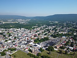
According to the U.S. Census Bureau, Hamburg has a total area of 1.9 square miles (5.0 km2), 1.9 square miles (4.9 km2) of which is land and 0.08 square miles (0.2 km2), or 3.55%, of which is water. [3]

Climate

It has a hot-summer humid continental climate (Dfa) and average monthly temperatures range from 28.4 °F in January to 73.4 °F in July. [5] The hardiness zone is 6b.

Climate data for Hamburg, Pennsylvania (1991–2020 normals, extremes 1894–present)
MonthJanFebMarAprMayJunJulAugSepOctNovDecYear
Record high °F (°C)69
(21)
78
(26)
88
(31)
95
(35)
97
(36)
102
(39)
107
(42)
103
(39)
100
(38)
89
(32)
80
(27)
75
(24)
107
(42)
Mean daily maximum °F (°C)37.7
(3.2)
40.6
(4.8)
49.9
(9.9)
62.5
(16.9)
72.6
(22.6)
80.9
(27.2)
85.3
(29.6)
83.1
(28.4)
76.1
(24.5)
64.3
(17.9)
52.6
(11.4)
42.0
(5.6)
62.3
(16.8)
Daily mean °F (°C)28.8
(−1.8)
31.2
(−0.4)
39.9
(4.4)
51.1
(10.6)
61.4
(16.3)
70.3
(21.3)
74.8
(23.8)
72.8
(22.7)
65.4
(18.6)
53.4
(11.9)
42.9
(6.1)
33.8
(1.0)
52.1
(11.2)
Mean daily minimum °F (°C)20.0
(−6.7)
21.9
(−5.6)
30.0
(−1.1)
39.8
(4.3)
50.3
(10.2)
59.6
(15.3)
64.4
(18.0)
62.5
(16.9)
54.7
(12.6)
42.4
(5.8)
33.2
(0.7)
25.6
(−3.6)
42.0
(5.6)
Record low °F (°C)−20
(−29)
−13
(−25)
−1
(−18)
10
(−12)
28
(−2)
35
(2)
37
(3)
39
(4)
30
(−1)
17
(−8)
6
(−14)
−10
(−23)
−20
(−29)
Average precipitation inches (mm)3.45
(88)
2.73
(69)
3.70
(94)
3.72
(94)
4.08
(104)
4.96
(126)
5.15
(131)
4.92
(125)
5.09
(129)
4.47
(114)
3.32
(84)
3.89
(99)
49.48
(1,257)
Average snowfall inches (cm)5.1
(13)
7.1
(18)
4.6
(12)
0.3
(0.76)
0.0
(0.0)
0.0
(0.0)
0.0
(0.0)
0.0
(0.0)
0.0
(0.0)
0.0
(0.0)
0.5
(1.3)
3.7
(9.4)
21.3
(54)
Average precipitation days (≥ 0.01 in)11.19.110.412.013.712.311.411.310.211.29.310.6132.6
Average snowy days (≥ 0.1 in)4.33.62.10.10.00.00.00.00.00.00.42.012.5
Source: NOAA [6] [7]

Demographics

Historical population
CensusPop.Note
1800 329
1830 560
1850 1,035
1860 1,33428.9%
1870 1,59019.2%
1880 2,01026.4%
1890 2,1275.8%
1900 2,3158.8%
1910 2,301−0.6%
1920 2,76420.1%
1930 3,63731.6%
1940 3,7172.2%
1950 3,8052.4%
1960 3,747−1.5%
1970 3,9094.3%
1980 4,0112.6%
1990 3,987−0.6%
2000 4,1143.2%
2010 4,2894.3%
2020 4,270−0.4%
Sources: [8] [9] [10] [2]

As of the census [9] of 2000, there were 4,114 people, 1,824 households, and 1,156 families residing in the borough. The population density was 2,212.2 inhabitants per square mile (854.1/km2). There were 1,932 housing units at an average density of 1,038.9 per square mile (401.1/km2). The racial makeup of the borough was 97.91% White, 0.34% African American, 0.12% Native American, 0.32% Asian, 0.49% from other races, and 0.83% from two or more races. Hispanic or Latino of any race were 0.83% of the population.

There were 1,824 households, out of which 25.7% had children under the age of 18 living with them, 50.7% were married couples living together, 9.1% had a female householder with no husband present, and 36.6% were non-families. 31.9% of all households were made up of individuals, and 16.9% had someone living alone who was 65 years of age or older. The average household size was 2.26 and the average family size was 2.82.

In the borough the population was spread out, with 21.1% under the age of 18, 7.2% from 18 to 24, 27.8% from 25 to 44, 23.4% from 45 to 64, and 20.6% who were 65 years of age or older. The median age was 40 years. For every 100 females, there were 88.8 males. For every 100 females age 18 and over, there were 84.1 males.

The median income for a household in the borough was $37,683, and the median income for a family was $50,957. Males had a median income of $37,650 versus $22,308 for females. The per capita income for the borough was $20,689. About 5.1% of families and 6.2% of the population were below the poverty line, including 11.4% of those under age 18 and 4.2% of those age 65 or over.

History

In 1779, Martin Kaercher Jr. received 250 acres (1.0 km2) of land from his father and divided it into building lots, naming the area "Kaercher Stadt". Hamburg was officially founded in 1787, generally thought to have been named after the "German Hamburg" due to the largely German population of the region. However, Martin Kaerscher Jr.'s father Johann Martin Kaerscher Sr. (1718-1787) emigrated in 1738 from Langenselbold in Hessia [11] which is far from the northern seaport of Hamburg, so it is likely that "Hamburg" is a corruption of Bad Homburg due to the Blue Mountains' very similar appearance to the Taunus mountain range. [12] [ citation needed ]

On July 1, 1798 Hamburg became the second town with postal designation in Berks County, preceded only by Reading.

The Centre Turnpike was created in 1812, running between the Reading and Pottsville. Hamburg began to grow rapidly due to the close proximity of a major roadway. Eight years later, the Schuylkill Canal was completed, followed quickly by railroad lines. Both of these advances in infrastructure had stops in Hamburg and helped spur population growth.

In 1837, Hamburg was officially organized as a borough.

The Hamburg Historic District, Hamburg Armory, and Hamburg Public Library are listed on the National Register of Historic Places. [13]

Education

The Hamburg Area School District is geographically the largest in all of Berks County with a size of 103 square miles (270 km2). Within this area there are on average 2600 students, ranging from kindergarten to high school. The school district includes the towns of Hamburg and Shoemakersville, as well as the rural townships of Perry, Tilden, Upper Bern, Upper Tulpehocken, and Windsor.

There are two elementary schools, one located in Tilden Township and the other located in Shoemakersville, that teach to students K-5. From there both schools combine into one middle school, grades 6–8, and then finally one high school, grades 9–12. Both the high school and middle school are located within Hamburg and are separated by less than 0.5 miles (800 m). There is also a nearby private high school, Blue Mountain Academy grades 9–12, that has an average enrollment of 204 students.

Of the 10 churches located in the Hamburg area, six of them offer a weekly Sunday or Sabbath school services. Many of these churches also have preschool programs for children too young to attend kindergarten.

Transportation

I-78/US 22 westbound in Hamburg 2022-09-01 09 45 13 View west along Interstate 78 and U.S. Route 22 (William Penn Highway) from the overpass for North Fourth Street in Hamburg, Berks County, Pennsylvania.jpg
I-78/US 22 westbound in Hamburg

As of 2015, there were 24.49 miles (39.41 km) of public roads in Hamburg, of which 5.03 miles (8.10 km) were maintained by the Pennsylvania Department of Transportation (PennDOT) and 19.46 miles (31.32 km) were maintained by the borough. [14]

The Interstate 78/U.S. Route 22 freeway passes through the borough, with access from Exit 30 (North 4th Street). It is 28 miles (45 km) west of Allentown and 54 miles (87 km) east of Harrisburg, the state capital. Pennsylvania Route 61 passes through the southern part of the borough, leading south 16 miles (26 km) to Reading and north 18 miles (29 km) to Pottsville.

Berks Area Regional Transportation Authority (BARTA) provides bus service to Hamburg along Route 20, which heads south along PA 61 to the BARTA Transportation Center in Reading. There is a park and ride lot at the Redner's in Hamburg that is served by BARTA. [15] Schuylkill Transportation System provides bus service to Hamburg along Route 80, which heads north into Schuylkill County to Union Station Intermodal Transit Center in Pottsville. [16]

Passenger rail service connected Hamburg at one time to Reading and Philadelphia to the east and Pottsville to the west via the Philadelphia and Reading main line. [17] Service ended in 1981 when SEPTA discontinued the Pottsville Line. [18] The Reading Blue Mountain and Northern Railroad provides freight service to Hamburg, with a branch line running south from Hamburg to Temple and its Reading Division mainline passing through West Hamburg. [19]

Attractions

The Reading Railroad Heritage Museum , located at 500 S 3rd Street, is dedicated to the preservation of the Reading Railroad. Featuring a permanent model train layout and several pieces of rolling stock from various eras before the Conrail merger in 1976, the museum is open year-round on Saturdays and Sundays.

Notable people

See also

Related Research Articles

<span class="mw-page-title-main">Berks County, Pennsylvania</span> County in Pennsylvania, United States

Berks County is a county in the Commonwealth of Pennsylvania. As of the 2020 census, the county's population was 428,849. The county seat is Reading, the fourth-most populous city in the state.

<span class="mw-page-title-main">Bernville, Pennsylvania</span> Borough in Pennsylvania, United States

Bernville is a borough in Berks County, Pennsylvania, United States. The population was 955 at the 2010 census. Bernville is bordered by Penn Township to the north, east, and south and by Jefferson Township to the west.

<span class="mw-page-title-main">Birdsboro, Pennsylvania</span> Borough in Pennsylvania, United States

Birdsboro is a borough in Berks County, Pennsylvania, United States. It is located along the Schuylkill River 8 miles (13 km) southeast of Reading. As of the 2010 census, it had a population of 5,163. Birdsboro's economy had historically been rooted in large foundries and machine shops, none of which remain in operation today.

<span class="mw-page-title-main">Boyertown, Pennsylvania</span> Borough in Pennsylvania, United States

Boyertown is a borough in Berks County, Pennsylvania, United States. The population was 4,055 at the 2010 census. Boyertown is known for the many painted fiberglass bears that can be found throughout the town and borough.

<span class="mw-page-title-main">Centre Township, Berks County, Pennsylvania</span> Township in Pennsylvania, United States

Centre Township is a township in Berks County, Pennsylvania, United States. The population was 4,140 at the 2020 census. It is in Schuylkill Valley School District.

<span class="mw-page-title-main">Cumru Township, Pennsylvania</span> Township in Pennsylvania, United States

Cumru Township is a township in Berks County, Pennsylvania, United States. The population was 15,638 at the 2020 census. Nolde Forest Environmental Education Center, a Pennsylvania state park, is in Cumru Township.

<span class="mw-page-title-main">Exeter Township, Berks County, Pennsylvania</span> Township in Pennsylvania, United States

Exeter Township is a township in Berks County, Pennsylvania, United States. The population was 25,500 as of the 2020 census, making it the third-most populous municipality in Berks County after the city of Reading and Spring Township. Daniel Boone Homestead is within its borders. This formerly rural township is now made up of mostly sprawl-oriented developments along U.S. Route 422 and Route 562 Its school district also contains the adjacent borough of St. Lawrence.

<span class="mw-page-title-main">Fleetwood, Pennsylvania</span> Borough in Pennsylvania, United States

Fleetwood, also called Schlegelschteddel in Pennsylvania Dutch, is a borough in Berks County, Pennsylvania, United States. The population was 4,085 at the 2010 census. It was home to the Fleetwood Metal Body company, an automobile coachbuilder purchased by Fisher Body and integrated into General Motors in 1931. The name lived on in the Cadillac Fleetwood automobile.

<span class="mw-page-title-main">Leesport, Pennsylvania</span> Borough in Pennsylvania, United States

Leesport is a borough in Berks County, Pennsylvania, United States. The population was 1,918 at the 2010 census.

<span class="mw-page-title-main">Muhlenberg Township, Berks County, Pennsylvania</span> Township in Pennsylvania, United States

Muhlenberg Township is a township in Berks County, Pennsylvania, United States. The population was 21,915 at the 2020 census, making it the third-most populous township in Berks County after Spring Township and Exeter Township.

<span class="mw-page-title-main">Ontelaunee Township, Pennsylvania</span> Township in Pennsylvania, United States

Ontelaunee Township is a township in Berks County, Pennsylvania, United States. The population was 1,646 at the 2010 census.

<span class="mw-page-title-main">Perry Township, Berks County, Pennsylvania</span> Township in Pennsylvania, United States

Perry Township is a township in Berks County, Pennsylvania, United States. The population was 2,417 at the 2010 census.

<span class="mw-page-title-main">Shoemakersville, Pennsylvania</span> Borough in Pennsylvania, United States

Shoemakersville is a borough in Berks County, Pennsylvania, United States. The population was 1,378 at the 2010 census, a decline from the figure of 2,124 tabulated in 2000.

<span class="mw-page-title-main">Tilden Township, Pennsylvania</span> Township in Pennsylvania, United States

Tilden Township is a township in Berks County, Pennsylvania, United States. The population was 3,597 at the 2010 census.

<span class="mw-page-title-main">Windsor Township, Berks County, Pennsylvania</span> Township in Pennsylvania, United States

Windsor Township is a township in Berks County, Pennsylvania, United States. The population was 2,279 at the 2010 census.

<span class="mw-page-title-main">Wyomissing, Pennsylvania</span> Borough in Pennsylvania, United States

Wyomissing is a borough in Berks County, Pennsylvania, United States, adjacent to Reading. The borough was incorporated on July 2, 1906. As of the 2020 census, the population was 11,114, compared to 10,461 at the 2010 census. The growth was significantly larger between 2000 and 2010 largely because of its merger in January 2002 with neighboring Wyomissing Hills. Wyomissing is the most populous borough in Berks County.

<span class="mw-page-title-main">Upper Providence Township, Montgomery County, Pennsylvania</span> Township in Pennsylvania, United States

Upper Providence Township is a township in Montgomery County, Pennsylvania, United States. As of the 2010 census, the township population was 21,219.

<span class="mw-page-title-main">Mount Carbon, Pennsylvania</span> Borough in Pennsylvania, United States

Mount Carbon is a borough in Schuylkill County, Pennsylvania, United States, two miles south of Pottsville. It was formed from North Manheim Township in 1864. The population was 88 in the 2020 census. The borough is the smallest municipality in Schuylkill County.

<span class="mw-page-title-main">Pottsville, Pennsylvania</span> City in Pennsylvania, United States

Pottsville is the county seat of Schuylkill County, Pennsylvania, United States. The population was 13,346 at the 2020 census, and is the principal city of the Pottsville, PA Micropolitan Statistical Area. The city lies along the west bank of the Schuylkill River, 52 miles (84 km) south of Wilkes-Barre. It is located in Pennsylvania's Coal Region.

<span class="mw-page-title-main">Schuylkill Haven, Pennsylvania</span> Borough in Pennsylvania, United States

Schuylkill Haven is a borough in Schuylkill County, Pennsylvania, United States. The borough's population was 5,253 as of the 2020 census. Schuylkill Haven is situated along the Schuylkill River, for which it is named. Schuylkill Haven is a focal point of activity in southern Schuylkill County.

References

  1. "ArcGIS REST Services Directory". United States Census Bureau. Retrieved October 12, 2022.
  2. 1 2 "Census Population API". United States Census Bureau. Retrieved Oct 12, 2022.
  3. 1 2 "Geographic Identifiers: 2010 Demographic Profile Data (G001): Hamburg borough, Pennsylvania". U.S. Census Bureau, American Factfinder. Archived from the original on February 12, 2020. Retrieved March 6, 2014.
  4. "US Gazetteer files: 2010, 2000, and 1990". United States Census Bureau. 2011-02-12. Retrieved 2011-04-23.
  5. "PRISM Climate Group at Oregon State University". Prism.oregonstate.edu. Retrieved 2022-03-20.
  6. "NowData – NOAA Online Weather Data". National Oceanic and Atmospheric Administration. Retrieved August 9, 2021.
  7. "Station: Hamburg, PA". U.S. Climate Normals 2020: U.S. Monthly Climate Normals (1991-2020). National Oceanic and Atmospheric Administration. Retrieved August 9, 2021.
  8. "Census of Population and Housing". U.S. Census Bureau. Retrieved 11 December 2013.
  9. 1 2 "U.S. Census website". United States Census Bureau . Retrieved 2008-01-31.
  10. "Incorporated Places and Minor Civil Divisions Datasets: Subcounty Resident Population Estimates: April 1, 2010 to July 1, 2012". Population Estimates. U.S. Census Bureau. Archived from the original on 11 June 2013. Retrieved 11 December 2013.
  11. https://ancestors.familysearch.org/en/LZLC-TSY/johann-martin-kaercher-1718-1787 [ bare URL ]
  12. https://dl101.zlibcdn.com/dtoken/374d6f7fc21c252afaeab52872e1c6e6 Archived 2021-05-24 at the Wayback Machine [ bare URL ]
  13. "National Register Information System". National Register of Historic Places . National Park Service. July 9, 2010.
  14. "Hamburg Borough map" (PDF). PennDOT. Retrieved March 13, 2023.
  15. "Route 20 schedule" (PDF). BARTA. Retrieved February 21, 2017.
  16. "Southern Loop 80 bus schedule" (PDF). Schuylkill Transportation System. Retrieved December 9, 2019.
  17. Bowen, Eli (1854). Philadelphia and Reading Railroad: Passenger Time Table.
  18. Williams, Gerry (1998). Trains, Trolleys & Transit: A Guide to Philadelphia Area Rail Transit. Piscataway, New Jersey: Railpace Company. p. 47. ISBN   978-0-9621541-7-1.
  19. Reading & Northern Railroad System Map (Map). Reading Blue Mountain and Northern Railroad. Retrieved July 16, 2017.