Mount Aetna, Pennsylvania | |
|---|---|
 House in Mount Aetna | |
 Interactive map of Mount Aetna, Pennsylvania | |
| Country | United States |
| State | Pennsylvania |
| County | Berks |
| Township | Tulpehocken |
| Area | |
• Total | 0.49 sq mi (1.28 km2) |
| • Land | 0.49 sq mi (1.28 km2) |
| • Water | 0 sq mi (0.00 km2) |
| Population | |
• Total | 489 |
| • Density | 988.2/sq mi (381.55/km2) |
| Time zone | UTC-5 (Eastern (EST)) |
| • Summer (DST) | UTC-4 (EDT) |
| ZIP codes | 19544 |
| FIPS code | 42-51320 |
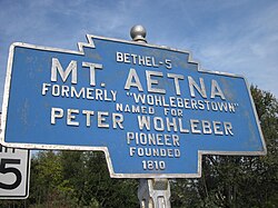
Mount Aetna is a census-designated place [3] in Tulpehocken Township, Berks County, Pennsylvania, United States. It is located along Pennsylvania Route 501 near the border of Lebanon County. The community is named after the active volcano, Mount Etna, in Sicily. As of the 2010 census, the population was 354 residents. [4]
