Bernville (Pennsylvania Dutch: Bannwill) is a borough in Berks County, Pennsylvania, United States. The population was 905 at the 2020 census.[3] Bernville is bordered by Penn Township to the north, east, and south and by Jefferson Township to the west. The borough would have been a county seat of a small county[4] allegedly with borders going as far west as Myerstown and as north as Meckville. Although no official source states it, it's said the county name would have been Tulpehocken County.
Before European settlers arrived in the Tulpehocken Creek valley, the area was inhabited by the Lenape people.[5] In 1723, thirty-three Palatine families from Schoharie, New York, moved to the confluences of the Tulpehocken and Northkill Creeks.[6][7][8] By 1735, a saw and grist mill was located three and a half miles up the Tulpehocken river from Bernville.[9]
In 1737, Stephanus Umbenhauer immigrated from Bern, Switzerland, and purchased 220 acres (0.89km2) from Thomas Penn. In 1819, Stephanus' grandson, Johann Thomas Umbenhauer, set aside 46 acres (190,000m2) to be divided into 62 lots. On 24 August 1819, Peter Bennethum bought the first six lots. In January 1820, the town was named Bernville after Stephanus' birthplace.[10] The first house was built by Philip Filbert in 1820.[11] In 1828, the Union Canal was completed, connecting the Susquehanna and Schuylkill rivers. Union Canal guard lock #36 and Lock #36 with a lift of 5.0 feet (1.5m) is located at the southwest corner of Bernville, near where Northkill Creek empties into Tulpehocken Creek. An historic marker on Route 183 states: "The canal, at this point, followed the north bank of the Tulpehocken. A dam, two locks, and a mule bridge made it possible for boats to cross Northkill Creek. Nearby were grist mills, a lime kiln, and a tannery."[12] Due to the proximity of the Bernville Locks and the town's location on the canal, Bernville was a primary and prospering canal port.[13][14]
In 1851, the village of Bernville, discontented with Penn Township's road maintenance and community services, incorporated as a borough.[13] The borough included the original 62 lots, most of which measured 60 by 260 feet (18 by 79m). In 1884, the Union Canal closed.[5] With no canal or railroad access, Bernville withered. In 1950, Bernville Borough annexed property from Penn Township at both ends of Main Street.[10]
Geography
Bernville is located at 40°26′1″N76°6′40″W / 40.43361°N 76.11111°W / 40.43361; -76.11111 (40.433742, -76.111039).[15] According to the U.S. Census Bureau, the borough has a total area of 0.42 square miles (1.1km2), of which 0.008 square miles (0.02km2), or 1.52%, is water.[3] The boundary with Jefferson Township is formed primarily by Northkill Creek, but diverges from the creek north of its confluence with Little Northkill Creek.
Buildings
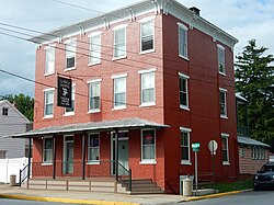
Main Street in Bernville
Main Street was laid out in 1819 and has numerous buildings dating back to the nineteenth century, including the Cyrus G. Blatt home (501-503 N. Main), the Eagle Hotel (301 N. Main) and the Joseph B. Conrad home (219 N. Main).[10] Main Street is also the location of both churches: St. Thomas's UCC, and Evangelical Lutheran Friedens Church. The churches are located across the street from each other.
As of the 2000 census,[17] there were 865 people, 351 households, and 249 families residing in the borough. The population density was 2,121.8 inhabitants per square mile (819.2/km2). There were 372 housing units at an average density of 912.5 per square mile (352.3/km2). The racial makeup of the borough was 98.03% White, 0.58% African American, 0.81% from other races, and 0.58% from two or more races. Hispanic or Latino of any race were 1.39% of the population.
There were 351 households, out of which 31.6% had children under the age of 18 living with them, 54.7% were married couples living together, 10.8% had a female householder with no husband present, and 28.8% were non-families. 22.8% of all households were made up of individuals, and 10.3% had someone living alone who was 65 years of age or older. The average household size was 2.46 and the average family size was 2.85.
In the borough, the population was spread out, with 25.2% under the age of 18, 5.8% from 18 to 24, 32.8% from 25 to 44, 20.1% from 45 to 64, and 16.1% who were 65 years of age or older. The median age was 36 years. For every 100 females there were 90.1 males. For every 100 females age 18 and over, there were 89.2 males.
The median income for a household in the borough was $41,250, and the median income for a family was $47,031. Males had a median income of $32,679 versus $25,109 for females. The per capita income for the borough was $19,038. About 7.5% of families and 8.2% of the population were below the poverty line, including 19.9% of those under age 18 and none of those age 65 or over.
Parks
Bernville has two parks. Umbenhauer Park, on Umbenhauer Drive, is home to a baseball field, tot-lot, and pavilion. Stanton Clay Park, on the corner of Third Street and Penn Valley Road, is home to a gazebo and a small field.
Northkill Creek feeds into Blue Marsh Lake, and the Blue Marsh slackwater is federal property. Hence a portion of Bernville is part of the Blue Marsh system. Blue Marsh Lake is a popular recreation site, offering hiking, boating, and fishing. The lake is also important for water supply, flood control, and wildlife habitat. A levee along Northkill Creek protects Bernville from Blue Marsh flooding above 300 feet (91m) elevation.[19]
As of 2020, there were 5.92 miles (9.53km) of public roads in Bernville, of which 1.15 miles (1.85km) were maintained by the Pennsylvania Department of Transportation (PennDOT) and 4.77 miles (7.68km) were maintained by the borough.[21]
Pennsylvania Route 183 is the only numbered highway serving Bernville. It follows Bernville Road along a northwest-to-southeast alignment on the southwest side of the borough. PA 183 was built on the route laid out for the South Mountain Railroad, which was never built.[22] Main Street runs parallel to PA 183 two blocks to the northeast. It divides Bernville roughly east–west and spans the length of the original borough.
Two covered bridges, which no longer exist, crossed Northkill Creek, connecting Bernville with Jefferson Township. The Northkill Covered Bridge, 1848-~1950, crossed at 4th Street. The South Bernville Covered Bridge, 1849–1938, crossed near the South Bernville Hotel (a.k.a., Newport Hotel).[22]
↑https://www.berkspa.gov/getmedia/2202604f-e0c9-4322-ada4-02f9537d66d7/Merged_Chapter_12.pdf |quote=As early as 1690, William Penn had the idea of a grand canal to connect the people of his lands with its resources and goods. In 1791, work on the Union Canal was initiated to connect the Schuylkill River and Schuylkill Canal with the Susquehanna River. Work continued until the canal was completed in 1828. The canal proved to be a strong boost to the area’s industrial and commercial growth. Bernville had become a thriving community by 1852 and was even considered for the County Seat. Railroads led to the demise of the Canal during the 1850’s and the Canal ceased operations in 1884. Today the Tulpehocken Creek Historic District protects the canal and other historic architecture along the canal.
↑"History of The Northkill Church / Evangelical Lutheran Friedens Church, Bernville, PA". Bernville, PA: Friedens Lutheran Church. Archived from the original on November 24, 2007. Retrieved November 14, 2008. Around the year 1723 Lutheran immigrants were found along the Tulpehocken and the twin Northkill Creeks. As early as 1729 Rev. John Casper Stoever gathered them into a congregation. The services were held in homes and in barns.
↑Early, J. W. (1904). "The Oldest Churches of Berks County". Transactions of the Historical Society of Berks County. Vol.I. Reading, PA: B. F. Owen & Co. p.4. Retrieved May 7, 2013. In the spring of 1723, thirty-three families of Germans, having been sorely oppressed and wronged, first by the Dutch and then by the English, and finally deprived of their lands and other possessions in the Schoharie, New York, came to Pennsylvania via the Susquehanna and Swatara, and settled near the Tulpehocken, about 15 miles west of the Schuylkill. These settlers established the Zion or Reed's Lutheran church.
↑Boehm, J. P. (1916). W. J. Hinke (ed.). Life and Letters of the Rev. John Philip Boehm. Philadelphia: Berger Bros. p.66. Retrieved November 17, 2008. Another congregation, which Boehm organized in 1727, was Tulpehocken. It had been settled by Palatines coming from the State of New York in 1723. Conrad Weiser describes its origin as follows: 'The people got news of the land on the Swatara and Tulpehocken in Pennsylvania. Many of them united and cut a road from Schoharie [N. Y.] to the Susquehanna River, carried their goods there, made canoes and floated them down the river to the mouth of the Swatara creek [where Middletown is situated at present], and drove their cattle over land. This happened in the spring of the year 1723. From there they came to Tulpehocken, and this was the beginning of the Tulpehocken settlement'.
↑Wagner, A. E.; F. W. Balthaser; D. K. Hoch (1913). The Story of Berks County. Reading, PA: Eagle Book and Job Press. pp.213–214. Retrieved November 9, 2008.
↑"Blue Marsh Lake, Bernville Protective Works. Design Memorandum Number 13 Schuylkill River basin. Tulpehocken Creek, Pennsylvania". U.S. Army Corps of Engineers. March 11, 1975. Archived from the original on May 20, 2011. Retrieved November 10, 2008. Abstract: Construction of protective works for the Borough of Bernville is necessary to relieve that community of flooding hazards created by the construction of the Blue Marsh Dam and Lake project. Below elevation 300 at the proposed project site lies a relatively uninhabited low-lying area which serves as an overbank flood plain. Many commercial and private improvements, as well as a utility substation and sewage treatment facility, lie above elevation 300. Therefore, elevation 300 was fixed as the upper allowable flooding elevation from project-induces flooding. Four alternate plans--and several options under each plan--were investigated and priced to determine the most economical way to provide effective flood protection acceptable to local officials/utility owners. The alternative selected called for diverting both the upper and middle tributaries of the Schuylkill River through culverts to Northkill Creek. This plan substantially reduced the size of the pond area and the anticipated use of part of this excavated material to construct the levee
↑"Blue Marsh". Mid-Atlantic Lost Ski Areas. DCSki, LLC. Retrieved November 18, 2008.
↑"Berks County Election Official Results"(PDF). Berks PA.gov. Reading, Pennsylvania: Berks County Office of Election Services. November 8, 2005. p.10. Retrieved June 1, 2025.
This page is based on this Wikipedia article Text is available under the CC BY-SA 4.0 license; additional terms may apply. Images, videos and audio are available under their respective licenses.