
Berks County is a county in the Commonwealth of Pennsylvania. As of the 2020 census, the county's population was 428,849. The county seat is Reading, the fourth-most populous city in the state.
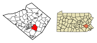
Exeter Township is a township in Berks County, Pennsylvania, United States. The population was 25,500 as of the 2020 census, making it the third-most populous municipality in Berks County after the city of Reading and Spring Township. Daniel Boone Homestead is within its borders. This formerly rural township is now made up of mostly sprawl-oriented developments along U.S. Route 422 and Route 562 Its school district also contains the adjacent borough of St. Lawrence.

Oley Township is a township in Berks County, Pennsylvania, United States. As of the 2010 census, the township had a population of 3,620. Oley Township was originally formed in 1740 as a part of Philadelphia County, before Berks County was formed in 1752. The entire township was listed as a historic district by the National Register of Historic Places in 1983. Oley is a Native American name purported to mean "a hollow". Daniel Boone was born in Oley Township November 2, 1734.

Pennsylvania Route 662 is a 26.17-mile-long (42.12 km) state highway located in Berks County in eastern Pennsylvania. Its southern terminus is at U.S. Route 422 in Douglassville and its northern terminus is at PA 61 in Shoemakersville. The route is a two-lane undivided road its entire length and passes through rural areas. PA 662 heads north from Douglassville, intersecting PA 562 in Yellow House before becoming concurrent with PA 73 northwest through Oley. From here, PA 662 continues north and meets PA 12 in Pricetown before passing through the borough of Fleetwood and coming to a junction with US 222 in Moselem Springs. After this, the route continues west and intersects PA 143 before reaching its terminus at PA 61.

Pennsylvania Route 562 is a state highway in Berks County, Pennsylvania. The route runs 13.92 mi (22.40 km) from U.S. Route 422 Business in St. Lawrence east to PA 73 in Boyertown. PA 562 is a two-lane undivided road its entire length, passing through rural areas of eastern Berks County as it connects Boyertown to the Reading area. Along the way, PA 562 intersects PA 662 in the community of Yellow House. PA 562 was first designated by 1930 between Stonersville and PA 62 southwest of Boyertown, running via Amityville and Yellow House. In the 1930s, the route was extended west to US 422 in St. Lawrence and was realigned to its current alignment. PA 562 was extended east to PA 73 in 1964 after PA 100 was shifted to a new alignment to the east of Boyertown.
Jacksonwald is a census-designated place that is located in Exeter Township, Berks County, Pennsylvania, United States. It is situated less than a mile from the borough of St. Lawrence.

Pricetown is a village in Ruscombmanor Township, Pennsylvania, United States, in Berks County. It is 10 miles from downtown Reading at the intersection of Pennsylvania Route 12 and Pennsylvania Route 662, and is served by the Oley Valley School District.
Manatawny is an unincorporated community in Berks County, Pennsylvania, United States. It is located at the junction on PA Route 73 and Hoch Road in Oley Township, a short distance from Pleasantville.

The 130th Pennsylvania House of Representatives District is located in Southeastern Pennsylvania and has been represented since 2011 by David M. Maloney.
Weavertown is an unincorporated community in Amity Township, Berks County, Pennsylvania, United States. It is located approximately 3.6 miles north of Amity Gardens on Pennsylvania Route 662 and is served by the Daniel Boone Area School District.
Plowville is an unincorporated area of Robeson Township, Berks County, Pennsylvania, United States. it is located on Pennsylvania Route 10, just east of Interstate 176. Its zip code is 19540 and the community is served by the Twin Valley School District. The most recognizable landmark is Plow Church.
Breezy Corner is an unincorporated community in Berks County, Pennsylvania, United States. The village is located northeast of Reading on South Mountain and is served by the Oley Valley School District. Breezy Corner is located along the border between Alsace Township and Ruscombmanor Township.

Joanna is an unincorporated community in southern Berks County, Pennsylvania, United States. Joanna sits in southern Robeson Township, near the borough of New Morgan, and is also near Caernarvon Township and near the Pennsylvania Turnpike. The Twin Valley School District serves Joanna; the high school is located close to the village.
Landis Store is a village in District Township, Berks County, Pennsylvania, United States. It is drained by the West Branch Perkiomen Creek into the Perkiomen Creek in the Green Lane Reservoir. It is split between the Alburtis zip code of 18011, the Barto zip code of 19504, and the Boyertown zip code of 19512.

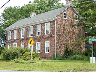
The Henry Fisher House is an historic, American home that is located in Oley Township, Berks County, Pennsylvania.

Oley, also called Friedensburg, is a census-designated place (CDP) that is located on Routes 73 and 662 in northern Oley Township, Berks County, United States.
Maxatawny is an unincorporated community located on U.S. Route 222 in Maxatawny Township, Berks County, Pennsylvania, United States, five miles east of Kutztown. It is in the Lehigh watershed and Schaefer Run flows through it to the Little Lehigh Creek. Maxatawny has a post office, with the ZIP code of 19538. Traffic speed on US 222 is reduced to 35 miles-per-hour passing through the village, which borders Lehigh County.
Eshbach is an unincorporated community in Washington Township in Berks County, Pennsylvania, United States. Eshbach is located at the intersection of Old Route 100 and Stauffer Road.
Limekiln is an unincorporated community in Berks County, Pennsylvania, United States. Limekiln is located at the intersection of Oley Turnpike Road and Limekiln Road on the border of Exeter and Oley townships.
Longswamp is an unincorporated community in Longswamp Township in Berks County, Pennsylvania, United States. Longswamp is located along State Street southeast of Topton.


