Pleasantville Manatawny | |
|---|---|
Unincorporated community | |
 PA 73 eastbound in the center of Pleasantville | |
 Pleasantville | |
| Coordinates: 40°23′03″N75°43′57″W / 40.384107°N 75.732611°W | |
| Country | United States |
| State | Pennsylvania |
| County | Berks |
| Township | Oley |
| Elevation | 177 ft (54 m) |
| Time zone | UTC-5 (Eastern (EST)) |
| • Summer (DST) | UTC-4 (EDT) |
| Area codes | 610 and 484 |
| GNIS feature ID | 1180258 [1] |
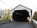
Pleasantville, also known as Manatawny, [2] is an unincorporated community in Oley Township, Berks County, Pennsylvania, United States. It is located at the junction of Pennsylvania Route 73 and Covered Bridge Road. Important places in Pleasantville include the Pleasantville Park, Pleasantville Covered Bridge, and Pleasantville Evangelical Church.
Contents
The village's alternate name comes from the Manatawny Creek which runs nearby. [2] [3]