Centerport, Pennsylvania

Last updated

Centerport, Pennsylvania
Main St, Centerport BerksCo PA 01.JPG
Main Street
Centerport.png
Location of Centerport in Berks County, Pennsylvania
USA Pennsylvania location map.svg
Red pog.svg
Centerport
Location of Centerport in Pennsylvania
Usa edcp location map.svg
Red pog.svg
Centerport
Centerport (the United States)
Coordinates: 40°29′12″N76°00′26″W / 40.48667°N 76.00722°W / 40.48667; -76.00722
CountryUnited States
StatePennsylvania
County Berks
Area
[1]
  Total0.17 sq mi (0.45 km2)
  Land0.17 sq mi (0.45 km2)
  Water0.00 sq mi (0.00 km2)
Elevation
348 ft (106 m)
Population
 (2020) [2]
  Total314
  Density1,804.60/sq mi (696.81/km2)
Time zone UTC-5 (EST)
  Summer (DST) UTC-4 (EDT)
ZIP Code
19516
Area code(s) 610 and 484
FIPS code 42-12104
Website www.township-directory.com/berks/Bor%20Centerport.htm

Centerport is a borough in north central Berks County, Pennsylvania, United States. The population was 314 at the 2020 census. The borough is in the Schuylkill Valley School District.

Contents

Geography

Centerport is located at 40°29′12″N76°0′26″W / 40.48667°N 76.00722°W / 40.48667; -76.00722 (40.486726, -76.007190). [3] According to the United States Census Bureau, the borough has a total area of 0.2 square miles (0.52 km2), all land. It drains southeastward to the nearby Schuylkill River.

Transportation

Main Street in Centerport 2022-08-22 11 05 27 View northwest along Main Street between Irish Creek Road and Chestnut Street in Centerport, Berks County, Pennsylvania.jpg
Main Street in Centerport

As of 2006, there were 2.02 miles (3.25 km) of public roads in Centerport, of which 1.12 miles (1.80 km) were maintained by the Pennsylvania Department of Transportation (PennDOT) and 0.90 miles (1.45 km) were maintained by the borough. [4]

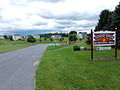
No numbered highways pass through Centerport. Main thoroughfares in the borough include Main Street, Centerport Road, Bernville Road and Shartlesville Road. The nearest state highway is Pennsylvania Route 61, which passes two miles to the east.

Demographics

Historical population
CensusPop.Note
1890 133
1900 1416.0%
1910 111−21.3%
1920 13420.7%
1930 1372.2%
1940 19139.4%
1950 22618.3%
1960 208−8.0%
1970 2279.1%
1980 2468.4%
1990 28415.4%
2000 32715.1%
2010 38718.3%
2020 314−18.9%
Sources: [5] [6] [7] [2]

As of the 2000 census, [6] there were 387 people, 149 households, and 107 families living in the borough. The population density was 1,935 inhabitants per square mile (747/km2). There were 150 housing units at an average density of 750 per square mile (290/km2). The racial makeup of the borough was 96.4% White, 0.5% African American, 0.5% Native American, and 2.6% from other races.. Hispanic or Latino of any race were 3.6% of the population.

There were 149 households, out of which 29.5% had children under the age of 18 living with them, 51.7% were married couples living together, 11.4% had a female householder with no husband present, and 28.2% were non-families. 21.5% of all households were made up of individuals, and 6.7% had someone living alone who was 65 years of age or older. The average household size was 2.60 and the average family size was 2.93.

In the borough, the population was spread out, with 24.0% under the age of 18, 9.6% from 18 to 24, 25.8% from 25 to 44, 24.6% from 45 to 64, and 16% who were 65 years of age or older. The median age was 37.9 years. Males made up 49.1% of the population and females made up 50.9%.

The median income for a household in the borough was $47,115, and the median income for a family was $51,250. Males had a median income of $30,938 versus $23,750 for females. The per capita income for the borough was $20,927. About 2.3% of families and 4.6% of the population were below the poverty line, including 3.3% of those under age 18 and 6.4% of those age 65 or over.

Landmarks

Centerport is known for having a literal nine foot tall fork in the road at the intersection of Main Street and Centerport Roadd.

Related Research Articles

<span class="mw-page-title-main">Bernville, Pennsylvania</span> Borough in Pennsylvania, United States

Bernville is a borough in Berks County, Pennsylvania, United States. The population was 905 at the 2020 census. Bernville is bordered by Penn Township to the north, east, and south and by Jefferson Township to the west. It is believed by few that the borough would have been a county seat of a small county called Tulpehocken County. However, no official sources can be found.

<span class="mw-page-title-main">Centre Township, Berks County, Pennsylvania</span> Township in Pennsylvania, United States

Centre Township is a township in Berks County, Pennsylvania, United States. The population was 4,140 at the 2020 census. It is in Schuylkill Valley School District.

<span class="mw-page-title-main">Hamburg, Pennsylvania</span> Borough in Pennsylvania, United States

Hamburg is a borough in Berks County, Pennsylvania, United States. The population was 4,270 at the 2020 census. The town is thought to have been named after Hamburg, Germany, but this is likely to have been a corruption of Bad Homburg.

<span class="mw-page-title-main">Leesport, Pennsylvania</span> Borough in Pennsylvania, United States

Leesport is a borough in Berks County, Pennsylvania, United States. The population was 1,954 at the 2020 census.

<span class="mw-page-title-main">Longswamp Township, Pennsylvania</span> Township in Pennsylvania, United States

Longswamp Township is a township in Berks County, Pennsylvania, United States. The population was 5,551 at the 2020 census.

<span class="mw-page-title-main">New Morgan, Pennsylvania</span> Borough in Berks County, Pennsylvania, United States

New Morgan is a borough in Berks County, Pennsylvania, United States. The population was 71 at the 2010 census.

<span class="mw-page-title-main">Shoemakersville, Pennsylvania</span> Borough in Pennsylvania, United States

Shoemakersville is a borough in Berks County, Pennsylvania, United States. The population was 1,378 at the 2010 census, a decline from the figure of 2,124 tabulated in 2000.

<span class="mw-page-title-main">Tilden Township, Pennsylvania</span> Township in Pennsylvania, United States

Tilden Township is a township in Berks County, Pennsylvania, United States. The population was 3,597 at the 2010 census.

<span class="mw-page-title-main">Topton, Pennsylvania</span> Borough in Pennsylvania, United States

Topton is a borough in Berks County, Pennsylvania, United States. The population was 2,069 at the 2010 census.

Locustdale is a census-designated place (CDP) that is located on the border of Columbia and Schuylkill counties, Pennsylvania, United States. It is part of Northeastern Pennsylvania.

<span class="mw-page-title-main">Auburn, Pennsylvania</span> Borough in Pennsylvania, United States

Auburn is a borough in Schuylkill County, Pennsylvania, United States. The population was 663 at the 2020 census.

<span class="mw-page-title-main">Cressona, Pennsylvania</span> Borough in Pennsylvania, United States

Cressona is a borough in Schuylkill County, Pennsylvania. Formed in 1857 from part of North Manheim Township, it was founded by and named for John Chapman Cresson, a Philadelphia civil engineer and manager of the Schuylkill Navigation Company, president of the Mine Hill and Schuylkill Haven Railroad, and the chief engineer of Fairmount Park in Philadelphia.

<span class="mw-page-title-main">Gilberton, Pennsylvania</span> Borough in Pennsylvania, United States

Gilberton is a borough in Schuylkill County, Pennsylvania, United States, four miles (7 km) west by south of Mahanoy City. Its population was 583 at the 2020 census, a decline from the figure of 769 tabulated in 2010. Extensive deposits of anthracite coal are in the region, and coal-mining had been practiced by many of the 4,373 people who lived there in 1900. The coal-mining industry was thriving in 1910, and 5,401 people lived in Gilberton.

<span class="mw-page-title-main">Landingville, Pennsylvania</span> Borough in Pennsylvania, United States

Landingville is a borough in Schuylkill County, Pennsylvania, United States. The population was 137 at the time of the 2020 census.

<span class="mw-page-title-main">Mechanicsville, Schuylkill County, Pennsylvania</span> Borough in Pennsylvania, United States

Mechanicsville is a borough in Schuylkill County, Pennsylvania, United States. Part of the Pottsville Area School District, it lies between Pottsville and Port Carbon. Pottsville Street is the community's main street.

<span class="mw-page-title-main">Orwigsburg, Pennsylvania</span> Borough in Pennsylvania, United States

Orwigsburg is a borough in Schuylkill County, Pennsylvania. The borough was named for its founder, Peter Orwig, and created from West Brunswick Township in 1823.

<span class="mw-page-title-main">Port Carbon, Pennsylvania</span> Borough in Pennsylvania, United States

Port Carbon is a borough of Schuylkill County, Pennsylvania, United States, located two miles (3 km) northeast of Pottsville. It is in a coal-mining area. In the past, ironworks had been a feature of the borough. In 1900, 2,168 people lived here and, in 1910, 2,678. The population was 1,815 at the 2020 census.

<span class="mw-page-title-main">Ringtown, Pennsylvania</span> Borough in Pennsylvania, United States

Ringtown is a borough that is located in Schuylkill County, Pennsylvania, United States. It is approximately five miles north to northwest of Shenandoah and seventeen miles west to southwest of Hazleton.

<span class="mw-page-title-main">Tremont, Pennsylvania</span> Borough in Pennsylvania, United States

Tremont is a borough in Schuylkill County, Pennsylvania, United States. Situated in the eastern section of Tremont Township, it was incorporated as a borough in 1866, around the same time that a water system was erected in the community.

<span class="mw-page-title-main">Wayne Township, Schuylkill County, Pennsylvania</span> Township in Pennsylvania, United States

Wayne Township is a township in Schuylkill County, Pennsylvania, United States. The population was 5,226 at the 2020 census. The township includes the village of Reedsville which contains a medium size state police barracks. Children from this township attend schools in the Blue Mountain School District. The township is divided by north-to-south PA Route 183 which serves as a highway connecting Schuylkill and Berks Counties. The Schuylkill County Fairgrounds are located in the township off east-to-west PA Route 895. 183 and 895 meet in the Census Designated Place of Summit Station.

References

  1. "ArcGIS REST Services Directory". United States Census Bureau. Retrieved October 12, 2022.
  2. 1 2 "Census Population API". United States Census Bureau. Retrieved October 12, 2022.
  3. "US Gazetteer files: 2010, 2000, and 1990". United States Census Bureau. February 12, 2011. Retrieved April 23, 2011.
  4. "Centerport Borough map" (PDF). PennDOT. Retrieved March 13, 2023.
  5. "Census of Population and Housing". U.S. Census Bureau. Retrieved December 11, 2013.
  6. 1 2 "U.S. Census website". United States Census Bureau . Retrieved January 31, 2008.
  7. "Incorporated Places and Minor Civil Divisions Datasets: Subcounty Resident Population Estimates: April 1, 2010 to July 1, 2012". Population Estimates. U.S. Census Bureau. Archived from the original on June 11, 2013. Retrieved December 11, 2013.