Grimville, Pennsylvania

Last updated

Grimville, Pennsylvania
Unincorporated community
Grimville, PA from hiway jeh.jpg
USA Pennsylvania location map.svg
Red pog.svg
Grimville
Usa edcp location map.svg
Red pog.svg
Grimville
Coordinates: 40°34′40″N75°47′5″W / 40.57778°N 75.78472°W / 40.57778; -75.78472
Country United States
State Pennsylvania
County Berks
Township Greenwich
Elevation
738 ft (225 m)
Time zone UTC-5 (Eastern (EST))
  Summer (DST) UTC-4 (EDT)
ZIP code
19530
Area code(s) 610 and 484
GNIS feature ID1203724 [1]

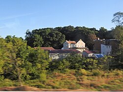
Grimville is an unincorporated community in Greenwich Township in Berks County, Pennsylvania, United States. Grimville is located at the intersection of Old Route 22 and Long Lane. [2] It is situated just east of Krumsville with its access to Interstate 78.

Related Research Articles

<span class="mw-page-title-main">Pennsylvania's 6th congressional district</span> U.S. House district for Pennsylvania

Pennsylvania's 6th congressional district is a district in the state of Pennsylvania. It includes all of Chester County, the city of Reading, and Reading's southeastern suburbs in Berks County. The district is represented by Democrat Chrissy Houlahan, who has served in Congress since 2019. As currently drawn, the district is among the wealthiest in Pennsylvania. The Supreme Court of Pennsylvania redrew the district in February 2018 after ruling the previous map unconstitutional.

<span class="mw-page-title-main">National Register of Historic Places listings in Berks County, Pennsylvania</span>

This is a list of the National Register of Historic Places listings in Berks County, Pennsylvania.

<span class="mw-page-title-main">Krumsville, Pennsylvania</span> Unincorporated community in Pennsylvania, United States

Krumsville is an unincorporated community in Greenwich Township in Berks County, Pennsylvania, United States. It is located at the intersection of Pennsylvania Route 737 and Old Route 22. The interchange with Interstate 78/U.S. Route 22 was redesigned and PA 737 now crosses I-78/US 22 on a new bridge. Important buildings in the area include the Greenwich-Lenhartsville Elementary School, Krumsville Inn, Mt. Zion's Church, and Dietrich's Meats.

Clayton is an unincorporated community in Berks County, Pennsylvania, United States. Clayton is located at the intersection of Pennsylvania Route 100, Church Hill Road, and Kutztown Road on the border of Hereford and Washington townships.

Dreibelbis is an unincorporated community in Greenwich Township in Berks County, Pennsylvania, United States.

Longswamp is an unincorporated community in Longswamp Township in Berks County, Pennsylvania, United States. Longswamp is located along State Street southeast of Topton.

Morysville is an unincorporated community in Colebrookdale Township in Berks County, Pennsylvania, United States. Morysville is located at the intersection of Pennsylvania Route 562 and Farmington Avenue.

Moselem is an unincorporated community in Richmond Township in Berks County, Pennsylvania, United States. Moselem is located along Pennsylvania Route 662, east of Maiden Creek.

Pikeville is an unincorporated community in Pike Township in Berks County, Pennsylvania, United States. Pikeville is located near the intersection of Lobachsville Road and Oysterdale Road.

Stony Run is an unincorporated community in Albany Township in Berks County, Pennsylvania, United States. Stony Run is located at the intersection of Pennsylvania Route 737 and Wessnerville Road.

Trexler is an unincorporated community in Albany Township in Berks County, Pennsylvania, United States. Trexler is located at the intersection of Pennsylvania Route 143 and Old Philly Pike.

Green Hills is an unincorporated community located in Robeson Township in Berks County, Pennsylvania, United States. Green Hills is located along Pennsylvania Route 10 north of Pennsylvania Route 568 at exit 7 of Interstate 176.

Tuckerton is an unincorporated community in Muhlenberg Township in Berks County, Pennsylvania, United States. Tuckerton is located at the intersection of Pennsylvania Route 61 and Tuckerton Road south of an interchange with U.S. Route 222.

Earlville is an unincorporated community on the border of Amity and Earl townships in Berks County, Pennsylvania, United States. Earlville is located along Pennsylvania Route 562 at the crossing of Manatawny Creek, west of Boyertown.

<span class="mw-page-title-main">Pennsylvania State Game Lands Number 43</span>

The Pennsylvania State Game Lands Number 43 are Pennsylvania State Game Lands in Berks and Chester Counties in Pennsylvania in the United States providing hunting, bird watching, and other activities. It is the only State Game Lands located in Chester County.

The Pennsylvania State Game Lands Number 80 are Pennsylvania State Game Lands in Berks, Lebanon and Schuylkill Counties in Pennsylvania, providing hunting, bird watching, and other activities.

The Pennsylvania State Game Lands Number 182 are Pennsylvania State Game Lands in Berks County in Pennsylvania in the United States providing hunting, bird watching, and other activities.

The Pennsylvania State Game Lands Number 274 are Pennsylvania State Game Lands in Berks and Lancaster Counties in Pennsylvania in the United States providing hunting, bird watching, and other activities.

The Pennsylvania State Game Lands Number 280 are Pennsylvania State Game Lands in Berks County in Pennsylvania in the United States providing hunting, bird watching, and other activities.

The Pennsylvania State Game Lands Number 324 are Pennsylvania State Game Lands in Berks County in Pennsylvania in the United States providing hunting, bird watching, and other activities.

References

  1. "Grimville". Geographic Names Information System . United States Geological Survey, United States Department of the Interior.
  2. Berks County, Pennsylvania Highway Map (PDF) (Map). PennDOT. 2012. Retrieved August 19, 2013.[ permanent dead link ]