
The Coal Region is a region of Northeastern Pennsylvania. It is known for being home to the largest known deposits of anthracite coal in the world with an estimated reserve of seven billion short tons.

Fogelsville is an unincorporated area in Lehigh County, Pennsylvania. It is a suburb of Allentown, in Upper Macungie Township, and is part of the Lehigh Valley, which has a population of 861,899 and was the 68th-most populous metropolitan area in the U.S. as of the 2020 census.

Wiconisco Creek is a tributary of the Susquehanna River in Schuylkill and Dauphin counties, Pennsylvania, in the United States. It is approximately 45.5 miles (73.2 km) long.

The Lehigh Crane Iron Company, later renamed Crane Iron Company, was a major ironmaking firm in the Lehigh Valley from its founding in 1839 until its sale in 1899. It was based in Catasauqua, Pennsylvania, and was founded by Josiah White and Erskine Hazard, who financed its development through their Lehigh Coal & Navigation Company, which promoted the then-novel technique of smelting iron ore with anthracite coal. This was an important cost and energy savings technique, credited with eliminating the need for either expensive charcoal or coke producing processes and transport costs that proved central to the acceleration of the American Industrial Revolution.

Little Lehigh Creek is approximately 24.0 miles (38.6 km) long and is located in the Lehigh Valley region of eastern Pennsylvania. It is sometimes referred to as the Little Lehigh River. It is the largest tributary of the Lehigh River.

The Thomas Iron Company was a major iron-making firm in Hokendauqua, Pennsylvania in the Lehigh Valley region of eastern Pennsylvania from its founding in 1854 until its decline and eventual dismantling in the early 20th century.
The Catasauqua and Fogelsville Railroad was built in the 1850s to transport iron ore from local mines in Lehigh and later Berks County to furnaces along the Lehigh River in eastern Pennsylvania. Originally owned by two iron companies, the railroad later became part of the Reading Company, and parts of it remain in operation today.

Black Creek is a long source tributary of Nescopeck Creek so part of the Susquehanna River drainage basin. It is also the second & longer stream of the same name recognized by the USGS GNIS system in Luzerne County, Pennsylvania, in the United States—compared to the Black Creek beyond the ridgeline of the drainage divide, so in the Lehigh River valley and Carbon County. The headwaters of both Black Creeks in Luzerne county are only a few miles apart, and both valleys were traversed by the Lausanne-Nescopeck Turnpike in the first half of the 19th-century.
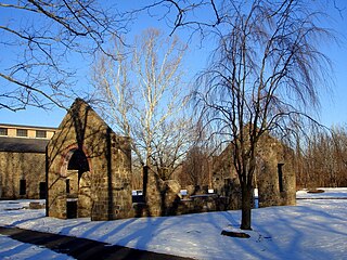
Lock Ridge Park is a park built around a historic iron ore blast furnace just outside Alburtis, Pennsylvania in the Lehigh Valley region of eastern Pennsylvania.

The Ironton Railroad was a shortline railroad in Lehigh County, Pennsylvania. Originally built in 1861 to haul iron ore and limestone to blast furnaces along the Lehigh River, traffic later shifted to carrying Portland cement when local iron mining declined in the early 20th century. Much of the railroad had already been abandoned when it became part of Conrail in 1976, and the last of its trackage was removed in 1984.

Duryea Yard is a railroad yard in the Wyoming Valley region of Northeastern Pennsylvania currently operated by the Reading Blue Mountain and Northern Railroad. Originally constructed in 1870 by Lehigh Valley Railroad as a turn-around and staging hub for coal transport from the Coal Region to Eastern big-city markets, the yard remains a hub for the energy extraction industry today.
West Catasauqua is an unincorporated village in Whitehall Township in Lehigh County, Pennsylvania. Once a port and station along the busy Lehigh Canal, it is colloquially known as West Catty. It is part of the Lehigh Valley, which has a population of 861,899 and is the 68th-most populous metropolitan area in the U.S. as of the 2020 census.
Hensingersville, also known as New Hensingersville, is an unincorporated community located mostly in southwestern Lower Macungie Township in Lehigh County, Pennsylvania. It also extends into Longswamp Township in Berks Township near the intersections of Pennsylvania Route 201, Pennsylvania Route 3001, Chestnut Road, and Reservoir Hill Road.

Swabia Creek is a tributary of Little Lehigh Creek in Berks and Lehigh Counties in the eastern Pennsylvania region of the Lehigh Valley.

Pisgah Mountain, or Pisgah Ridge on older USGS maps, is a ridgeline running 12.5 miles (20.1 km) from Tamaqua to Jim Thorpe, Pennsylvania from the Little Schuylkill River water gap to the Lehigh River water gap.
Nesquehoning Mountain or Nesquehoning Ridge is a 15–17-mile-long (24–27 km) coal bearing ridge dividing the waters of Lehigh Valley to the north from the Schuylkill River valley and the several near parallel ridgelines of the Ridge-and-valley Appalachians barrier range all local members of which run generally WSW-ENE in the greater overall area.
Mauch Chunk Ridge or Mauch Chunk Mountain is a historically important barrier ridgeline north of the Blue Mountain escarpment and 3rd parallel ridgeline south of the Nesquehoning Creek after Nesquehoning Mountain and Pisgah Ridge in the Ridge-and-Valley Appalachians of Northeastern Pennsylvania.

Catasauqua Creek is an ENE–SSW oriented creek draining 6.6 miles (10.6 km) from springs of the Blue Mountain barrier ridge several miles below the Lehigh Gap in the Ridge-and-Valley Appalachians located upriver and opposite from Allentown in Lehigh and Northampton counties in the Lehigh Valley region of eastern Pennsylvania.

Nescopeck Mountain is a ridge in Columbia County and Luzerne County, in Pennsylvania, in the United States. Its elevation is 1,594 feet (486 m) above sea level. The ridge is a forested ridge, with at least two types of forest and two systems of vernal pools. It is a very long and unbroken ridge with two water gaps: one carved by Catawissa Creek and one carved by Nescopeck Creek. This later gap was exploited as a transportation corridor with the construction of the Lausanne–Nescopeck Turnpike between the respective frontier communities at Lausanne Landing and Nescopeck in 1805 connecting the newly developing Wyoming Valley with Philadelphia and the Delaware River valley; cutting off over 100 miles between Philadelphia and Wilkes-Barre. Today's Route PA 93 derives from this historic pack mule road.
Hazle Creek is an American tributary source stream of the Lehigh and Delaware Rivers in the Commonwealth of Pennsylvania in the United States.
