Shartlesville, Pennsylvania | |
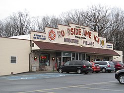
---|---|
Coordinates: 40°30′46″N76°06′16″W / 40.51278°N 76.10444°W | |
Country | United States |
State | Pennsylvania |
County | Berks |
Township | Upper Bern |
Elevation | 568 ft (173 m) |
Population (2010) | |
• Total | 455 |
Time zone | UTC-5 (Eastern (EST)) |
• Summer (DST) | UTC-4 (EDT) |
ZIP Code | 19554 |
Area code(s) | 610 & 484 |
GNIS feature ID | 1187386 [1] |
Shartlesville is a census-designated place [2] that is located in Upper Bern Township, Berks County, Pennsylvania, United States. As of the 2010 census, the population was 455 residents. [3]
Shartlesville, which was founded in 1765, was named for the Shartle family of farmers and innkeepers, and particularly for Peter Shartle, a pioneer settler and colonel during the Revolutionary War. [4]
This American town is located just south of Interstate 78 on the south side of Blue Mountain. It is drained by Wolf Creek south into the Northkill Creek, a tributary of the Tulpehocken Creek.
The village has a box post office with the ZIP code of 19554, but outlying areas use the Bernville ZIP code of 19506 or the Hamburg ZIP code of 19526. [5] [6] It is served by the Hamburg Area School District.
It is home to the Shartlesville Hotel, which suffered major roof damage in February 2009 during a wind storm that also knocked down a billboard in Reading, Pennsylvania, and blew off roof tiles of the Pagoda in eastern Reading.
The community was also the home of Roadside America, a large community of miniature trains and villages, located off Interstate 78, that was open to the public at that location from 1953 until 2020, when the attraction was closed, largely due to the COVID-19 pandemic. [7] [8]
Just to the north of Shartlesville was the Mountain Springs Arena, which hosted events including rodeos, concerts, horse shows, demolition derbies, tractor pulls, and an annual country fair.
Census | Pop. | Note | %± |
---|---|---|---|
2010 | 455 | — | |
2020 | 404 | −11.2% | |
2022 (est.) | 345 | [9] | −14.6% |
US Census [10] |
Racial and ethnic composition | 2010 [11] | 2020 [12] |
---|---|---|
White (non-Hispanic) | 94.29% | 90.35% |
Hispanic or Latino (of any race) | 5.05% | 3.47% |
Two or more races (non-Hispanic) | 0.22% | 2.97% |
Black or African American (non-Hispanic) | 0.0% | 1.73% |
Other (non-Hispanic) | 0.22% | 1.24% |
Asian (non-Hispanic) | 0.22% | 0.25% |
Native American (non-Hispanic) | 0.0% | 0.0% |
Pacific Islander (non-Hispanic) | 0.0% | 0.0% |
Berks County is a county in the Commonwealth of Pennsylvania. As of the 2020 census, the county's population was 428,849. The county seat is Reading, the fourth-most populous city in the state.
Limestone Creek is a census-designated place (CDP) in Palm Beach County, Florida, United States. It is part of the Miami metropolitan area of South Florida. The population was 1,316 at the 2020 US census.
Belle Rose is a census-designated place (CDP) in Assumption Parish, Louisiana, United States. The population was 1,902 at the 2010 census. It is part of the Pierre Part micropolitan statistical area.
Upper Bern Township is a township in Berks County, Pennsylvania, United States. The population was 1,734 at the 2010 census.
West Hazleton is a borough in Luzerne County, Pennsylvania, United States. The borough is 31 miles (50 km) south of Wilkes Barre and had a population of 5,167 as of the 2020 census.
Nanafalia is an unincorporated community and census-designated place (CDP) in Marengo County, Alabama, United States. As of the 2020 census, its population was 75, down from 94 at the 2010 census. The community is located on a ridge above the Tombigbee River, and the name is derived from the Choctaw words for long hill. Nanafalia has a post office with a zip code of 36764.
Archer is an unincorporated rural small town and census-designated place (CDP) in Merrick County, Nebraska, United States. As of the 2020 census the population was 68. The Archer post office carries the ZIP Code 68816.
Jalappa is a village in Tilden Township, Berks County, Pennsylvania, United States. It is located on Old Route 22, less than one mile south of Interstate 78. Access to 78 is from Hamburg and Shartlesville. The Mill Creek flows eastward through the village to the Schuylkill River. The village uses the Hamburg ZIP code of 19526.
Bowers is a census-designated place in Maxatawny Township, Berks County, Pennsylvania.
Cherokee Pass is an unincorporated community and census-designated place in Madison County, Missouri, United States. As of the 2020 census, it had a population of 271, up from 235 in 2010.
Boody is an unincorporated community and census-designated place (CDP) in Macon County, Illinois, United States. As of the 2020 census, Boody had a population of 232, down from 276 in 2010. Boody has a post office with ZIP code 62514.
Boomer is a census-designated place (CDP) in Fayette County, West Virginia, United States. Boomer is located on the north bank of the Kanawha River, 2 miles (3.2 km) southeast of Smithers. Boomer has a post office with ZIP code 25031. As of the 2010 census, its population was 615.
Holiday Island is a 4,500-acre planned retirement and vacation community in Carroll County, Arkansas, United States. Formerly an unincorporated community and census-designated place, it voted to incorporate in November 2020. As of the 2020 census, the population was 2,533. Holiday Island is located in the Ozark Mountains on Table Rock Lake, near Eureka Springs, Arkansas and approximately an hour's drive from Branson, Missouri, Fayetteville, Arkansas, and Bentonville, Arkansas. Community growth has been fueled by the expansion of corporate giants headquartered in Northwest Arkansas, namely Walmart, Tyson Foods, and J.B. Hunt; the entertainment attractions in Eureka Springs, AR and Branson, MO; the visitor traffic from the Crystal Bridges Museum of American Art, the Pea Ridge National Military Park, and the Roaring River State Park; and the influence of University of Arkansas, the state's largest university.
Scenic is an unincorporated community and census-designated place (CDP) in Mohave County in extreme northwestern Arizona, United States. As of the 2020 census, its population was 1,321, down from 1,643 in 2010.
Oley, also called Friedensburg, is a census-designated place (CDP) that is located on Routes 73 and 662 in northern Oley Township, Berks County, United States.
Huson is a census-designated place and unincorporated community in Missoula County, Montana, United States. Its population was 256 as of the 2020 census, up from 210 in 2010.
Maxatawny is an unincorporated community and census-designated place located on U.S. Route 222 in Maxatawny Township, Berks County, Pennsylvania, United States, five miles east of Kutztown. It is in the Lehigh watershed and Schaefer Run flows through it to the Little Lehigh Creek. Maxatawny has a post office, with the ZIP code of 19538. Traffic speed on US 222 is reduced to 35 miles-per-hour passing through the village, which borders Lehigh County.
McAllister is an unincorporated community and census-designated place in Madison County, Montana, United States. As of the 2020 census, it had a population of 278. McAllister is located on U.S. Route 287, 6 miles (10 km) north of Ennis. The community has a post office with ZIP code 59740.
Walnut Creek is an unincorporated community and census-designated place (CDP) in Mohave County, in the U.S. state of Arizona. The population was 571 at the 2020 census.
Eagle Point is a census-designated place in Shelby County, Alabama, United States. It was first listed as a CDP prior to the 2020 census and is part of the Birmingham Metropolitan Area. The area was struck by a long-tracked low-end EF3 tornado on March 25, 2021, damaging or destroying several homes and downing trees. Five people were injured by the tornado.
{{cite web}}
: CS1 maint: numeric names: authors list (link)