York County, Pennsylvania

Last updated

York County
York, Pennsylvania (48).jpg
York County Administrative Center in York, Pennsylvania
York County pa seal.jpg
Map of Pennsylvania highlighting York County.svg
Location within the U.S. state of Pennsylvania
Pennsylvania in United States.svg
Pennsylvania's location within the U.S.
Coordinates: 39°55′N76°44′W / 39.92°N 76.73°W / 39.92; -76.73
CountryFlag of the United States.svg United States
StateFlag of Pennsylvania.svg  Pennsylvania
FoundedAugust 19, 1749
Named for Duke of York
Seat York
Largest cityYork
Area
  Total
911 sq mi (2,360 km2)
  Land904 sq mi (2,340 km2)
  Water6.5 sq mi (17 km2)  0.7%
Population
 (2020)
  Total
456,438
  Density481.1/sq mi (185.8/km2)
Time zone UTC−5 (Eastern)
  Summer (DST) UTC−4 (EDT)
Congressional districts 10th, 11th
Website yorkcountypa.gov

York County is a county in the Commonwealth of Pennsylvania, United States. As of the 2020 census, the population was 456,438. [1] Its county seat is York. [2] The county was created on August 19, 1749, from part of Lancaster County and named either after the Duke of York, an early patron of the Penn family, or for the city and county of York in England. The county is part of the South Central region of the state. [a]

Contents

York County comprises the York-Hanover, Pennsylvania Metropolitan Statistical Area, which is also included in the Harrisburg-York-Lebanon, Pennsylvania combined statistical area. It is in the Susquehanna Valley, a large fertile agricultural region in South Central Pennsylvania.

Based on the Articles of Confederation having been adopted in York by the Second Continental Congress on November 15, 1777, the local government and business community began referring to York in the 1960s as the first capital of the United States of America. The designation has been debated by historians ever since. [3] Congress considered York and the borough of Wrightsville on the eastern side of York County along the Susquehanna River as the nation's permanent capital before Washington, D.C. was selected. [4]

York County is home to Martin's Potato Chips in Thomasville; Utz Quality Foods, Inc., Snyder's of Hanover, and Hanover Foods in Hanover; Gibble's Potato Chips, and Wolfgang Candy in York; the Emigsville Band in Emigsville; a major manufacturing branch of Harley-Davidson Motor Company, the York International brand of refrigeration/HVAC equipment, and York Barbell. York was the home of The Bon-Ton from 1898 to 2018, and Dentsply Sirona until 2019. [5]

Geography

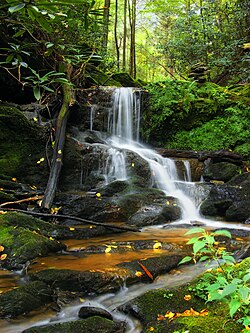
An Oakland Run waterfall near the Mason-Dixon Trail in southeast York County in October 2009 Lower Channeled.jpg
An Oakland Run waterfall near the Mason-Dixon Trail in southeast York County in October 2009
A farm in York County in June 2007 Countryside in York County PA.jpg
A farm in York County in June 2007

According to the U.S. Census Bureau, the county has a total area of 911 square miles (2,360 km2), of which 904 square miles (2,340 km2) is land and 6.5 square miles (17 km2) (0.7%) is water. [6] The county is bound to its eastern border by the Susquehanna River. Its southern border is the Mason–Dixon line, which separates Pennsylvania and Maryland. Within the U.S. piedmont region, York County is generally hilly and rises to the Blue Ridge Mountains in the northwest, where it is bordered by Yellow Breeches Creek. Interior waterways include Codorus and Conewago Creeks, and Lakes Lehman, [7] Kiwanis, Marburg, Pahagaco, Pinchot, Redman, and Williams. [8]

Adjacent counties

Major roads and highways

Climate

Most of York County has a hot-summer humid continental climate (Dfa) and the hardiness zones are 6b and 7a. The latest temperature averages show some low-lying eastern areas of the county to have a humid subtropical climate (Cfa.)

Climate data for York, Pennsylvania (1991-2020 normals)
MonthJanFebMarAprMayJunJulAugSepOctNovDecYear
Mean daily maximum °F (°C)41.2
(5.1)
45.3
(7.4)
54.5
(12.5)
67.2
(19.6)
76.5
(24.7)
83.9
(28.8)
87.7
(30.9)
86.0
(30.0)
79.7
(26.5)
68.2
(20.1)
55.7
(13.2)
44.9
(7.2)
65.9
(18.8)
Daily mean °F (°C)31.2
(−0.4)
34.3
(1.3)
42.4
(5.8)
53.6
(12.0)
63.1
(17.3)
71.2
(21.8)
75.4
(24.1)
73.8
(23.2)
67.1
(19.5)
55.6
(13.1)
44.4
(6.9)
35.5
(1.9)
54.0
(12.2)
Mean daily minimum °F (°C)21.3
(−5.9)
23.2
(−4.9)
30.2
(−1.0)
40.0
(4.4)
49.7
(9.8)
58.5
(14.7)
63.1
(17.3)
61.5
(16.4)
54.5
(12.5)
43.0
(6.1)
33.1
(0.6)
26.1
(−3.3)
42.0
(5.6)
Average precipitation inches (mm)3.27
(83)
2.81
(71)
4.01
(102)
3.62
(92)
4.20
(107)
4.29
(109)
4.52
(115)
3.96
(101)
5.10
(130)
3.94
(100)
3.22
(82)
3.52
(89)
46.46
(1,180)
Average snowfall inches (cm)8.5
(22)
8.2
(21)
3.9
(9.9)
0.2
(0.51)
0.0
(0.0)
0.0
(0.0)
0.0
(0.0)
0.0
(0.0)
0.0
(0.0)
0.0
(0.0)
0.5
(1.3)
3.3
(8.4)
24.6
(62)
Average precipitation days (≥ 0.01 in)10.39.611.611.612.712.011.09.69.68.410.010.5126.9
Average snowy days (≥ 0.1 in)3.33.01.70.20.00.00.00.00.00.00.31.510.0
Source: NOAA [9] [10]
Climate data for Harrisburg, Pennsylvania (Harrisburg Capital City Airport) 1991-2020 normals (Records 1939-2021)
MonthJanFebMarAprMayJunJulAugSepOctNovDecYear
Record high °F (°C)73
(23)
83
(28)
86
(30)
93
(34)
97
(36)
100
(38)
107
(42)
101
(38)
102
(39)
97
(36)
84
(29)
75
(24)
107
(42)
Mean daily maximum °F (°C)40.3
(4.6)
43.2
(6.2)
52.6
(11.4)
64.9
(18.3)
74.7
(23.7)
83.2
(28.4)
87.6
(30.9)
85.4
(29.7)
78.6
(25.9)
66.7
(19.3)
55.1
(12.8)
44.4
(6.9)
64.7
(18.2)
Daily mean °F (°C)32.6
(0.3)
34.7
(1.5)
43.2
(6.2)
54.1
(12.3)
64.0
(17.8)
73.0
(22.8)
77.5
(25.3)
75.4
(24.1)
68.5
(20.3)
56.7
(13.7)
46.0
(7.8)
37.0
(2.8)
55.2
(12.9)
Mean daily minimum °F (°C)24.9
(−3.9)
26.2
(−3.2)
33.9
(1.1)
43.3
(6.3)
53.2
(11.8)
62.8
(17.1)
67.4
(19.7)
65.5
(18.6)
58.4
(14.7)
46.7
(8.2)
37.0
(2.8)
29.5
(−1.4)
45.7
(7.6)
Record low °F (°C)−9
(−23)
−5
(−21)
2
(−17)
19
(−7)
31
(−1)
40
(4)
49
(9)
45
(7)
30
(−1)
23
(−5)
13
(−11)
−8
(−22)
−9
(−23)
Average precipitation inches (mm)2.64
(67)
2.36
(60)
3.35
(85)
3.70
(94)
3.48
(88)
3.72
(94)
4.30
(109)
3.68
(93)
4.12
(105)
3.68
(93)
2.80
(71)
3.15
(80)
40.98
(1,041)
Average precipitation days (≥ 0.01 in)991012141212111011910127
Source: NOAA [11]

Demographics

Historical population
CensusPop.Note
1790 37,535
1800 25,643−31.7%
1810 31,95824.6%
1820 38,75921.3%
1830 42,85910.6%
1840 47,0109.7%
1850 57,45022.2%
1860 68,20018.7%
1870 76,13411.6%
1880 87,84115.4%
1890 99,48913.3%
1900 116,41317.0%
1910 136,40517.2%
1920 144,5215.9%
1930 167,13515.6%
1940 178,0226.5%
1950 202,73713.9%
1960 238,33617.6%
1970 272,60314.4%
1980 312,96314.8%
1990 339,5748.5%
2000 381,75112.4%
2010 434,97213.9%
2020 456,4384.9%
U.S. Decennial Census [12]
1790–1960 [13] 1900–1990 [14]
1990–2000 [15] 2010–2019 [1]

As of the 2000 census, [16] there were 381,751 people, 148,219 households, and 105,531 families residing in the county. The population density was 422 people per square mile (163 people/km2). There were 156,720 housing units at an average density of 173 units per square mile (67/km2). The racial makeup of the county was 92.76% White, 3.69% African American, 0.18% Native American, 0.86% Asian, 0.03% Pacific Islander, 1.39% from other races, and 1.10% from two or more races. Hispanic or Latino people of any race were 2.96% of the population. 42.0% were of German, 12.6% American, 7.7% Irish, 6.4% English and 5.1% Italian ancestry. 94.8% spoke English and 2.9% Spanish as their first language.

There were 148,219 households, out of which 32.50% had children under the age of 18 living with them, 58.30% were married couples living together, 9.00% had a female householder with no husband present, and 28.80% were non-families. 23.30% of all households were made up of individuals, and 9.20% had someone living alone who was 65 years of age or older. The average household size was 2.52 and the average family size was 2.98.

In the county, the population was spread out, with 24.60% under the age of 18, 7.50% from 18 to 24, 30.30% from 25 to 44, 24.00% from 45 to 64, and 13.50% who were 65 years of age or older. The median age was 38 years. For every 100 females there were 96.70 males. For every 100 females age 18 and over, there were 93.80 males.

As of 2006, the York-Hanover Metropolitan Statistical Area was the fastest-growing metro area in the Northeast region, and was ranked among the fastest-growing in the nation, according to the "2006 Population Estimates for Metropolitan and Micropolitan Statistical Areas" (U.S. Census Bureau). The estimates listed York-Hanover as the 95th fastest-growing metro area in the nation, increasing 9.1 percent between 2000 and 2006.

York city had a 77.3 percent increase in the number of residents of Hispanic or Latino origin, based on a comparison of the 2000 and 2010 U.S. census results. [17] The city's 30.9 percent Hispanic population (as of December 2017) is more than that of other places in the area. [18]

2020 census

York County racial composition [19]
RaceNum.Perc.
White (NH)365,35380%
Black or African American (NH)25,7685.64%
Native American (NH)6400.14%
Asian (NH)6,5571.43%
Pacific Islander (NH)1180.03%
Other/mixed (NH)18,6424.1%
Hispanic or Latino 39,3608.62%

Dialect

The Central Pennsylvania accent and the Susquehanna dialect are the two most commonly heard speech patterns in the county. Many people of Pennsylvania Dutch descent also inhabit the county, who tend to speak with a Pennsylvania Dutch English dialect.[ citation needed ]

Metropolitan statistical area

The U.S. Office of Management and Budget has designated York County as the York–Hanover, PA metropolitan statistical area (MSA). [20] The United States Census Bureau ranked the York–Hanover, PA Metropolitan Statistical Area as the 9th most populous in the state of Pennsylvania, and 115th most populous MSA in the United States as of July 1, 2012. [21]

The Office of Management and Budget has further designated the York–Hanover MSA as a component of the more extensive Harrisburg–York–Lebanon combined statistical area (CSA), [20] the 43rd most populous CSA and the 49th most populous primary statistical area of the United States as of July 1, 2012. [21] [22] As of the 2017 estimates, the CSA's 1.26 million people ranks 5th in the state of Pennsylvania.[ citation needed ]

Politics and government

Prior to 1952, York County was a Democratic stronghold in presidential elections, voting majority Republican only four times before then. Between the founding of the party in 1828 and 1900, the county voted Democratic every time, one of only a handful of counties in Pennsylvania to do so. [23] Starting with the 1952 election, it has become a Republican stronghold with Lyndon Johnson being the lone Democrat to win the county since. Since then, Jimmy Carter in 1976 and Barack Obama in 2008 are the only Democratic presidential candidates who have received over 40% of the county's vote, and George H. W. Bush in 1992 is the only Republican not to win a majority. The only real pockets of Democratic support are in the city of York, which has sent Democrats to the state house without interruption since 1985.

United States presidential election results for York County, Pennsylvania [24]
Year Republican Democratic Third party(ies)
No.%No.%No.%
2024 154,88462.15%91,92636.89%2,3990.96%
2020 146,73361.36%88,11436.85%4,2991.80%
2016 128,52861.78%68,52432.94%10,9775.28%
2012 113,30459.63%73,19138.52%3,5101.85%
2008 109,26855.95%82,83942.42%3,1791.63%
2004 114,27063.74%63,70135.53%1,2980.72%
2000 87,65260.75%51,95836.01%4,6763.24%
1996 65,18850.87%49,59638.70%13,37210.43%
1992 60,13044.79%46,11334.35%28,00220.86%
1988 72,40865.16%37,69133.92%1,0170.92%
1984 75,02068.67%33,35930.54%8680.79%
1980 61,09859.96%33,40632.79%7,3877.25%
1976 56,91256.94%41,28141.30%1,7511.75%
1972 63,60668.19%27,52029.50%2,1542.31%
1968 51,63155.30%33,32835.69%8,4129.01%
1964 33,67736.26%58,78763.30%4080.44%
1960 55,92258.57%39,16441.02%3930.41%
1956 48,17655.33%38,74344.50%1490.17%
1952 44,48952.74%39,50846.84%3540.42%
1948 32,49447.31%33,32148.52%2,8634.17%
1944 32,61745.84%38,22653.72%3150.44%
1940 30,22843.22%39,54356.54%1650.24%
1936 29,23338.55%45,14259.53%1,4621.93%
1932 25,43044.33%29,31351.10%2,6224.57%
1928 45,79179.60%11,21619.50%5220.91%
1924 23,04456.15%15,60038.01%2,3955.84%
1920 19,87955.72%14,39640.35%1,4043.94%
1916 12,27640.12%16,31453.32%2,0086.56%
1912 5,25117.39%14,97949.61%9,96533.00%
1908 14,61047.48%15,17149.30%9903.22%
1904 14,83751.85%12,99645.42%7812.73%
1900 12,32746.29%13,73251.56%5722.15%
1896 12,25847.04%13,05450.09%7482.87%
1892 9,05240.59%12,82257.50%4261.91%
1888 9,04741.68%12,35956.94%3011.39%
1884 8,01440.68%11,55258.65%1320.67%
1880 7,87040.43%11,58159.49%170.09%

According to the Secretary of State's office, a majority of voters in York County are registered as Republicans. As of March 4, 2024, there were 310,874 registered voters in the county. [25]

Chart of Voter Registration

   Republican (52.00%)
   Democratic (31.02%)
   Independent (14.01%)
   Other parties (2.96%)

County commissioners

  • Julie Wheeler, President, Republican
  • Scott Burford, Vice President, Republican
  • Doug Hoke, Commissioner, Democrat [26]

Other county offices

  • Clerk of Courts, Dan Byrnes, Republican [27]
  • Controller, Greg Bower, Republican
  • Coroner, Pamela Gay, Republican [28]
  • District Attorney, David Sunday, Republican [29]
  • Prothonotary, Allison Blew, Republican [30]
  • Recorder of Deeds, Laura Shue, Republican [31]
  • Register of Wills & Clerk of Orphans' Court, Bryan Tate, Republican [32]
  • Sheriff, Richard P. Keuerleber III, Republican [33]
  • Treasurer, Barbara Bair, Republican [34]

[35]

State House of Representatives

DistrictRepresentative [36] Party
47 Joe D'Orsie Republican
92 Dawn Keefer Republican
93 Mike Jones Republican
94 Wendy Fink Republican
95 Carol Hill-Evans Democratic
169 Kate Klunk Republican
196 Seth Grove Republican

State senate

DistrictSenatorParty
28 Kristin Phillips-Hill Republican
31 Mike Regan Republican
33 Doug Mastriano Republican
48 Chris Gebhard Republican

United States House of Representatives

DistrictRepresentative [35] Party
10 Scott Perry Republican
11 Lloyd Smucker Republican

United States Senate

SenatorParty
Bob Casey Democratic
John Fetterman Democratic

Education

Map of York County's public school districts More Color Map of York County Pennsylvania School Districts.png
Map of York County's public school districts

Public school districts

Vocational school

Public charter schools

  • Crispus Attucks Youthbuild Charter School (K–6) – York
  • Helen Thackston Charter School (6–12) – York [37]
  • Lincoln Charter School (K–5) – York
  • New Hope Academy Charter School (K–6) – York
  • York Academy Regional Charter School
  • York Adams Academy (formerly York County High School)

Independent schools

  • Christian School of York (PreK–12)
  • Keystone Christian Academy York (K–8)
  • Logos Academy York (K–12)
  • St. Joseph School Hanover (PreK–8)
  • St. Joseph School (PreK–6)
  • St. John the Baptist Catholic School New Freedom (PreK–6)
  • Shrewsbury Christian Academy New Freedom (PreK–8)
  • Tidings of Peace Christian School York (K–12)
  • York Catholic High School (7–12)
  • York Country Day School (PreK–12)

Intermediate Unit

Lincoln Intermediate Unit (IU#12) region includes Adams County, Franklin County and York County. The agency offers school districts, home schooled students and private schools many services including: special education services, combined purchasing, and instructional technology services. It runs Summer Academy which offers both art and academic strands designed to meet the individual needs of gifted, talented and high achieving students. Additional services include: Curriculum Mapping, Professional Development for school employees, Adult Education, Nonpublic School Services, Business Services, Migrant & ESL (English as a Second Language), Instructional Services, Management Services, and Technology Services. It also provides a GED program to adults who want to earn a high school diploma and literacy programs. The Lincoln Intermediate Unit is governed by a 13-member Board of Directors, each a member of a local school board from the 25 school districts. Board members are elected by school directors of all 25 school districts for three-year terms that begin the first day of July. [38] There are 29 intermediate units in Pennsylvania. They are funded by school districts, state and federal program specific funding and grants. IUs do not have the power to tax.

Colleges and universities

Adult education

Communities

Map of York County with municipal labels showing cities and boroughs (in red), townships (in white), and census-designated places (in blue) Map of York County Pennsylvania With Municipal and Township Labels.png
Map of York County with municipal labels showing cities and boroughs (in red), townships (in white), and census-designated places (in blue)

Under Pennsylvania law, there are four types of incorporated municipalities: cities, boroughs, townships, and, in only one case, towns. York County has 72 of these. The following cities, boroughs and townships are in York County:

City

Boroughs

Townships

Census-designated places

Census-designated places are unincorporated communities designated by the U.S. Census Bureau for the purposes of compiling demographic data. They are not actual jurisdictions under Pennsylvania law.

Other unincorporated communities

Population ranking

The population ranking of the following table is based on the 2010 census of York County. [39]

county seat

RankCity/town/etc.Municipal typePopulation (2010 Census)
1 York City43,718
2 Hanover Borough15,289
3 Weigelstown CDP12,875
4 Shiloh CDP11,218
5 East York CDP8,777
6 Parkville CDP6,706
7 Red Lion Borough6,373
8 Spry CDP4,891
9 West York Borough4,617
10 New Freedom Borough4,464
11 Dallastown Borough4,049
12 Shrewsbury Borough3,823
13 Grantley CDP3,628
14 Valley Green CDP3,429
15 Valley View CDP2,817
16 Manchester Borough2,763
17 Hallam Borough2,673
18 Emigsville CDP2,672
19 Dillsburg Borough2,563
20 Stonybrook CDP2,384
21 Wrightsville Borough2,310
22 Susquehanna Trails CDP2,264
23 Spring Grove Borough2,167
24 Stewartstown Borough2,089
25 Glen Rock Borough2,025
26 Dover Borough2,007
27 Pennville CDP1,947
28 North York Borough1,914
29 Yorklyn CDP1,912
30 Tyler Run CDP1,901
31 Jacobus Borough1,841
32 Queens Gate CDP1,464
33 Mount Wolf Borough1,393
34 Windsor Borough1,319
35 Loganville Borough1,240
36 Yoe Borough1,018
37 Goldsboro Borough952
38 East Prospect Borough905
39 New Market CDP816
40 Jefferson Borough733
41 Delta Borough728
42 York Haven Borough709
43 Winterstown Borough632
44 New Salem Borough579
45 Seven Valleys Borough517
46 Cross Roads Borough512
47 Felton Borough506
48 Franklintown Borough489
49 Fawn Grove Borough452
50 Lewisberry Borough362
51 Railroad Borough278
52 Wellsville Borough242
53 Yorkana Borough229

Airports

Although York County has no scheduled passenger air service, it has two general-aviation airports: Capital City Airport in Fairview Township in the extreme north and York Airport near Thomasville, just south of US 30. The county participates in the Susquehanna Area Regional Airport Authority with Adams, Cumberland, Dauphin, and Franklin counties. The closest passenger service is at Harrisburg International Airport, Lancaster County Airport, and BWI.

Notable people

See also

Related Research Articles

<span class="mw-page-title-main">Adams County, Pennsylvania</span> County in Pennsylvania, United States

Adams County is a county in the Commonwealth of Pennsylvania. As of the 2020 census, the population was 103,852. Its county seat is Gettysburg. The county was created on January 22, 1800, from part of York County, and was named for the second President of the United States, John Adams. On July 1–3, 1863, a crucial battle of the American Civil War was fought near Gettysburg; Adams County, as a result, is a center for Civil War-related tourism. The county is part of the South Central Pennsylvania region of the state. Adams County comprises the Gettysburg metropolitan statistical area, which is also included in the Harrisburg–York–Lebanon combined statistical area.

<span class="mw-page-title-main">Wyoming County, Pennsylvania</span> County in Pennsylvania, United States

Wyoming County is a county in the Commonwealth of Pennsylvania. As of the 2020 census, the population was 26,069. Its county seat is Tunkhannock. It was created in 1842 from part of Luzerne County. The county is part of the Northeast Pennsylvania region of the state.

<span class="mw-page-title-main">Union County, Pennsylvania</span> County in Pennsylvania, United States

Union County is a county in the Commonwealth of Pennsylvania. As of the 2020 census, the population was 42,681. Its county seat is Lewisburg. The county was created on March 22, 1813, from part of Northumberland County. Its name is an allusion to the federal Union. Mifflinburg was established by legislation as the first county seat until it was moved to New Berlin in 1815. Lewisburg became county seat in 1855 and has remained so since. Union County comprises the Lewisburg, PA Micropolitan Statistical Area, which is also included in the Bloomsburg-Berwick-Sunbury, PA Combined Statistical Area. The county is part of the Central Pennsylvania region of the state.

<span class="mw-page-title-main">Susquehanna County, Pennsylvania</span> County in Pennsylvania, United States

Susquehanna County is a county in the Commonwealth of Pennsylvania. As of the 2020 census, the population was 38,434 Its county seat is Montrose. The county was created on February 21, 1810, from part of Luzerne County and later organized in 1812. It is named for the Susquehanna River. The county is part of the Northeast Pennsylvania region of the state.

<span class="mw-page-title-main">Snyder County, Pennsylvania</span> County in Pennsylvania, United States

Snyder County is a county in the Commonwealth of Pennsylvania. As of the 2020 census, the population was 39,736. The county seat is Middleburg. Snyder County was formed in 1855 from parts of Union County. The county is part of the Central Pennsylvania region of the state.

<span class="mw-page-title-main">Northumberland County, Pennsylvania</span> County in Pennsylvania, United States

Northumberland County is a county in the Commonwealth of Pennsylvania. As of the 2020 census, the population was 91,647. Its county seat is Sunbury. The county is part of the Central Pennsylvania region of the state.

<span class="mw-page-title-main">Montour County, Pennsylvania</span> County in Pennsylvania, United States

Montour County is a county in the Commonwealth of Pennsylvania. As of the 2020 census, the population was 18,136. Its county seat is Danville. The county is named for Andrew Montour, a prominent Métis interpreter who served with George Washington during the French and Indian War. It encompasses 132 sq mi, making it the smallest county by land area in the state. The county is part of the Central Pennsylvania region of the state.

<span class="mw-page-title-main">Lycoming County, Pennsylvania</span> County in Pennsylvania, United States

Lycoming County is a county in the Commonwealth of Pennsylvania. As of the 2020 census, the population was 114,188. Its county seat is Williamsport. The county is part of the Central Pennsylvania region of the state.

<span class="mw-page-title-main">Lebanon County, Pennsylvania</span> County in Pennsylvania, United States

LebanonCounty is a county in the Commonwealth of Pennsylvania, United States. As of the 2020 census, the population was 143,257. Its county seat is the city of Lebanon. It lies 72 miles northwest of Philadelphia, which is the nearest major city. The county is part of the South Central Pennsylvania region of the state.

<span class="mw-page-title-main">Lackawanna County, Pennsylvania</span> County in Pennsylvania, United States

Lackawanna County is a county in the Commonwealth of Pennsylvania. It is located in Northeastern Pennsylvania and had a population of 215,615 (2022). Its county seat and most populous city is Scranton.

<span class="mw-page-title-main">Dauphin County, Pennsylvania</span> County in Pennsylvania, United States

Dauphin County is a county in the Commonwealth of Pennsylvania. As of the 2020 census, the population was 286,401. The county seat is Harrisburg, Pennsylvania's state capital and ninth-most populous city. The county was created on March 4, 1785, from part of Lancaster County and was named after Louis Joseph, Dauphin of France, the first son of King Louis XVI. The county is part of the South Central Pennsylvania region of the state.

<span class="mw-page-title-main">Columbia County, Pennsylvania</span> County in Pennsylvania, United States

Columbia County is a county in the Commonwealth of Pennsylvania. It is located in Northeastern Pennsylvania. As of the 2020 census, the population was 64,727. Its county seat is Bloomsburg. The county was created on March 22, 1813, from part of Northumberland County. It was named Columbia, alluding to the United States and Christopher Columbus. The county is part of the Central Pennsylvania region of the state.

<span class="mw-page-title-main">Clearfield County, Pennsylvania</span> County in Pennsylvania, United States

Clearfield County is a county in the Commonwealth of Pennsylvania. As of the 2020 census, the population was 80,562. The county seat is Clearfield, and the largest city is DuBois. The county was created in 1804 and later organized in 1822.

<span class="mw-page-title-main">Bradford County, Pennsylvania</span> County in Pennsylvania, United States

Bradford County is a county in the Commonwealth of Pennsylvania. As of the 2020 census, its population was 59,967. Its county seat is Towanda. The county was created on February 21, 1810, from parts of Lycoming and Luzerne Counties. Originally called Ontario County, it was reorganized and separated from Lycoming County on October 13, 1812, and renamed Bradford County for William Bradford, who had been a chief justice of the Pennsylvania Supreme Court and United States Attorney General. The county is part of the Northeast Pennsylvania region of the state.

<span class="mw-page-title-main">Blair County, Pennsylvania</span> County in Pennsylvania, United States

Blair County is a county in the Commonwealth of Pennsylvania. As of the 2020 census, the population was 122,822. Its county seat is Hollidaysburg, and its largest city is Altoona. The county was created on February 26, 1846, from parts of Huntingdon and Bedford counties. The county is part of the Southwest Pennsylvania region of the state.

<span class="mw-page-title-main">Dallastown, Pennsylvania</span> Borough in Pennsylvania, United States

Dallastown is a borough in York County, Pennsylvania, United States. The population was 4,195 at the 2020 census. It is part of the York–Hanover metropolitan area.

<span class="mw-page-title-main">Hallam, Pennsylvania</span> Borough in Pennsylvania, United States

Hallam is a borough in York County, Pennsylvania, United States. The population was 2,774 at the 2020 census. It is part of the York–Hanover metropolitan area.

<span class="mw-page-title-main">Wrightsville, Pennsylvania</span> Borough in Pennsylvania, United States

Wrightsville is a borough in York County, Pennsylvania, United States. The population was 2,257 at the time of the 2020 census. It is part of the York–Hanover metropolitan area.

<span class="mw-page-title-main">Cumberland County, Pennsylvania</span> County in Pennsylvania, United States

Cumberland County is a county in the Commonwealth of Pennsylvania. As of the 2020 census, the population was 259,469. Its county seat is Carlisle. The county is part of the South Central Pennsylvania region of the state.

<span class="mw-page-title-main">Pennsylvania Route 214</span> State highway in York County, Pennsylvania, US

Pennsylvania Route 214 is an 11.3-mile-long (18.2 km) state highway located in York County, Pennsylvania. The western terminus is at PA 616 in Seven Valleys. The eastern terminus is at PA 74 in Dallastown. PA 214 is a two-lane undivided road that runs through rural areas to the south of York. Along the way, the route passes through Loganville, where it has indirect access to Interstate 83 (I-83). PA 214 was designated between PA 616 in Seven Valleys and PA 74 in Dallastown in 1961. In 2009, the route was shifted to bypass West Ore Street through the western portion of Loganville to the north in order to provide more direct access to I-83.

References

  1. Includes Lancaster, York, Berks, Dauphin, Cumberland, Franklin, Lebanon, Adams and Perry Counties
  1. 1 2 "U.S. Census Bureau QuickFacts: United States". United States Census Bureau. Retrieved August 12, 2021.
  2. "Find a County". National Association of Counties. Retrieved July 2, 2016.
  3. McClure, Jim (December 9, 2007). "York: 'The first capital of the United States?'". York Town Square. York Daily Record/Sunday News. Retrieved May 17, 2009.
  4. "1776–1789". York Daily Record/Sunday News. September 14, 2006. Retrieved May 16, 2009.
  5. "Dentsply Sirona Board Approves Relocation of Headquarters to Charlotte N.C. and Announces CFO Transition Plan" (Press release). Dentsply Sirona. May 23, 2019. Retrieved January 10, 2024.
  6. "2010 Census Gazetteer Files". United States Census Bureau. August 22, 2012. Retrieved March 11, 2015.
  7. "Lake Lehman in York County PA". Pennsylvania Gazetteer. Retrieved August 31, 2022.
  8. "York County Pennsylvania". Encyclopaedia Britannica. Retrieved May 26, 2020.
  9. NOWData – NOAA Online Weather Data, National Oceanic and Atmospheric Administration
  10. "Monthly Normals 1991-2020". National Oceanic and Atmospheric Administration . Retrieved July 23, 2022.
  11. "NowData – NOAA Online Weather Data". National Oceanic and Atmospheric Administration . Retrieved May 12, 2021.
  12. "U.S. Decennial Census". United States Census Bureau. Retrieved March 11, 2015.
  13. "Historical Census Browser". University of Virginia Library. Retrieved March 11, 2015.
  14. Forstall, Richard L., ed. (March 24, 1995). "Population of Counties by Decennial Census: 1900 to 1990". United States Census Bureau. Retrieved March 11, 2015.
  15. "Census 2000 PHC-T-4. Ranking Tables for Counties: 1990 and 2000" (PDF). United States Census Bureau. April 2, 2001. Archived (PDF) from the original on October 9, 2022. Retrieved March 11, 2015.
  16. "U.S. Census website". United States Census Bureau . Retrieved May 14, 2011.
  17. "York, Pennsylvania Population: Census 2010 and 2000 Interactive Map, Demographics, Statistics, Quick Facts". CensusViewer. Retrieved May 28, 2018.
  18. "York, Pennsylvania Demographics Data". TownCharts. Archived from the original on September 27, 2016. Retrieved May 28, 2018. ... York shows it has 30.9% people who are Hispanic or Latino which is more than all other places in the area.{{cite web}}: CS1 maint: unfit URL (link)
  19. "P2 Hispanic or Latino, and Not Hispanic or Latino by Race – 2020: Dec Redistricting Data (PL 94-171) – York County, Pennsylvania".
  20. 1 2 "OMB Bulletin No. 13-01: Revised Delineations of Metropolitan Statistical Areas, Micropolitan Statistical Areas, and Combined Statistical Areas, and Guidance on Uses of the Delineations of These Areas" (PDF). Office of Management and Budget . February 28, 2013. Archived (PDF) from the original on January 21, 2017. Retrieved March 20, 2013 via National Archives.
  21. 1 2 "Table 1. Annual Estimates of the Population of Metropolitan and Micropolitan Statistical Areas: April 1, 2010 to July 1, 2012". 2012 Population Estimates. United States Census Bureau, Population Division. March 2013. Archived from the original (CSV) on April 1, 2013. Retrieved March 20, 2013.
  22. "Table 2. Annual Estimates of the Population of Combined Statistical Areas: April 1, 2010 to July 1, 2012". 2012 Population Estimates. United States Census Bureau, Population Division. March 2013. Archived from the original (CSV) on May 17, 2013. Retrieved March 20, 2013.
  23. "Presidential election of 1828 – Map by counties". geoelections.free.fr. Retrieved March 19, 2022.
  24. Leip, David. "Dave Leip's Atlas of U.S. Presidential Elections". uselectionatlas.org. Retrieved November 29, 2018.
  25. Pennsylvania Department of State (May 15, 2023). "Voter registration statistics by county". dos.pa.gov. Retrieved May 17, 2023.
  26. "Past Commissioners". York County, Pennsylvania. Retrieved March 6, 2020.
  27. "Chief Clerk". York County, Pennsylvania. Retrieved March 6, 2020.
  28. "Coroner". York County, Pennsylvania. Retrieved March 6, 2020.
  29. "District Attorney of York County, Pennsylvania". York District Attorney. Retrieved March 6, 2020.
  30. "Prothonotory". York County, Pennsylvania. Retrieved March 6, 2020.
  31. "Recorder of Deeds". York County, Pennsylvania. Retrieved March 6, 2020.
  32. "Register of Wills". York County, Pennsylvania. Retrieved March 6, 2020.
  33. "Sheriff's Office – About Us". York County, Pennsylvania. Retrieved March 6, 2020.
  34. "Treasurer". York County, Pennsylvania. Retrieved March 6, 2020.
  35. 1 2 "Elected Officials". York County Republican Committee. Retrieved March 6, 2020.
  36. "Members of the House". Pennsylvania House of Representatives. Retrieved July 13, 2013.
  37. Pennsylvania Operating Charter Schools 2009–10, Pennsylvania Department of Education Report September 2009
  38. "Lincoln Intermediate Unit 12". iu12.org. Archived from the original on May 5, 2010. Retrieved April 24, 2010.
  39. "2010 U.S. Census website". United States Census Bureau . Retrieved February 10, 2013.
  40. Maisel, Matt (June 18, 2021). "York County's Hali Flickinger Olympics bound after 200M butterfly win at U.S. Trials". FOX43 . Retrieved July 21, 2021.
  41. Freireich, Gordon. "How York shaped three-star Admiral Chip Miller". York Daily Record. Retrieved August 27, 2020.
  42. "Snickers Surging to Top of Global Candy Race". Ad Age. September 20, 2012. Retrieved March 17, 2018.
  43. Linder, Brian (June 22, 2023). "NBA Draft 2023: Former central Pa. star taken in first round by Wizards, promptly traded to Pacers". The Patriot-News . Retrieved June 23, 2023. born in Baltimore but grew up in New Freedom

Further reading