Winterstown, Pennsylvania

Last updated
Winterstown, Pennsylvania
Borough
Winter in Winterstown.jpg
Snowy landscape at the northern end of Main Street
York County Pennsylvania incorporated and unincorporated areas Winterstown highlighted.svg
Location in York County and the U.S. state of Pennsylvania.
USA Pennsylvania location map.svg
Red pog.svg
Winterstown
Location of Winterstown in Pennsylvania
Usa edcp location map.svg
Red pog.svg
Winterstown
Winterstown (the United States)
Coordinates: 39°50′25″N76°37′27″W / 39.84028°N 76.62417°W / 39.84028; -76.62417 Coordinates: 39°50′25″N76°37′27″W / 39.84028°N 76.62417°W / 39.84028; -76.62417
Country United States
State Pennsylvania
County York
Settled1830
Incorporated1871
Government
  TypeBorough Council
Area
[1]
  Total2.41 sq mi (6.25 km2)
  Land2.41 sq mi (6.25 km2)
  Water0.00 sq mi (0.00 km2)
Elevation
807 ft (246 m)
Population
 (2020) [2]
  Total608
  Density251.86/sq mi (97.24/km2)
Time zone UTC-5 (Eastern (EST))
  Summer (DST) UTC-4 (EDT)
Area code 717
FIPS code 42-85872

Winterstown is a borough in York County, Pennsylvania, United States. The population was 609 at the time of the 2020 census. [3]

Contents

History

Townsend Winters, a resident of Steuben County, New York, purchased a four-hundred-acre tract of heavily forested land in York County, Pennsylvania, circa 1830, from the heirs of Reverend John Smith for two thousand dollars. After clearing portions of the land, Winters began work on building a house there and planted an apple orchard. As other settlers made their way to this area of the county, Winters cleared more of the land, and began sectioning it into individual lots, which he subsequently sold to the new arrivals. That first community, which would later become known as the Borough of Winterstown, was initially named Apple Grove in recognition of the thriving orchard that Winters had planted. Prior to completing work on his house, Winters then sold his home and land to Daniel Brenneman, who completed work on the structure, then built a blacksmith shop there. [4]

The town of Apple Grove was renamed to Winterstown sometime thereafter and surveyed by William Norris. On January 2, 1871, it was officially incorporated as a borough. [5]

Geography

Winterstown is located at 39°50′25″N76°37′27″W / 39.84028°N 76.62417°W / 39.84028; -76.62417 (39.840346, -76.624125). [6]

According to the United States Census Bureau, the borough has a total area of 2.3 square miles (6.0 km2), all of it land.

Demographics

Historical population
CensusPop.Note
1880 199
1890 2095.0%
1900 2173.8%
1910 2389.7%
1920 222−6.7%
1930 219−1.4%
1940 26521.0%
1950 29812.5%
1960 34917.1%
1970 42421.5%
1980 49115.8%
1990 58118.3%
2000 546−6.0%
2010 63215.8%
2020 609−3.6%
2021 (est.)607 [3] −0.3%
U.S. Decennial Census [7]

As of the census [8] of 2000, there were 546 people, 207 households, and 162 families living in the borough.

The population density was 234.1 people per square mile (90.5/km2). There were 215 housing units at an average density of 92.2 per square mile (35.6/km2).

The racial makeup of the borough was 99.45% White, 0.18% African American, and 0.37% from two or more races.

There were 207 households, out of which 33.8% had children under the age of eighteen living with them; 66.2% were married couples living together, 7.7% had a female householder with no husband present, and 21.3% were non-families. 15.5% of all households were made up of individuals, and 5.8% had someone living alone who was sixty-five years of age or older.

The average household size was 2.64 and the average family size was 2.93.

In the borough the population was spread out, with 23.4% under the age of eighteen, 7.0% from eighteen to twenty-four, 33.3% from twenty-five to forty-four, 25.1% from forty-five to sixty-four, and 11.2% who were sixty-five years of age or older. The median age was thirty-seven years.

For every one hundred females there were 106.0 males. For every one hundred females who were aged eighteen or older, there were 101.9 males.

The median income for a household in the borough was $45,625, and the median income for a family was $47,917. Males had a median income of $33,523 compared with that of $23,583 for females.

The per capita income for the borough was $19,934.

Roughly 3.6% of families and 4.6% of the population were living below the poverty line, including 7.5% of those who were under the age of eighteen and 9.5% of those who were aged sixty-five or older.

Related Research Articles

<span class="mw-page-title-main">Sylvania, Pennsylvania</span> Borough in Pennsylvania, United States

Sylvania is a borough in Bradford County, Pennsylvania, United States. It is part of Northeastern Pennsylvania. The population was 216 at the 2020 census. Children residing in the borough are assigned to attend the Troy Area School District.

<span class="mw-page-title-main">Shiremanstown, Pennsylvania</span> Borough in Pennsylvania, United States

Shiremanstown is a borough in Cumberland County, Pennsylvania, United States. Bordered to the north by Hampden Township and to the south by Lower Allen Township, it is part of the Harrisburg–Carlisle Metropolitan Statistical Area.

<span class="mw-page-title-main">Gratz, Pennsylvania</span> Borough in Pennsylvania, United States

Gratz is a borough in Dauphin County, Pennsylvania, United States. The population was 743 at the time of the 2020 census, a decline from the figure of 765 in 2010.

<span class="mw-page-title-main">Royalton, Pennsylvania</span> Borough in Pennsylvania, United States

Royalton is a borough in Dauphin County, Pennsylvania, United States. As of the 2020 census the borough population was 1,134.

<span class="mw-page-title-main">Jefferson Township, Greene County, Pennsylvania</span> Township in Pennsylvania, United States

Jefferson Township is a township that is located in Greene County, Pennsylvania, United States. The population was 2,359 at the time of the 2020 census, up from 2,352 at the 2010 census.

<span class="mw-page-title-main">New Buffalo, Pennsylvania</span> Borough in Pennsylvania, United States

New Buffalo is a borough in Perry County, Pennsylvania, United States. The population was 124 at the time of the 2020 census.

<span class="mw-page-title-main">Landingville, Pennsylvania</span> Borough in Pennsylvania, United States

Landingville is a borough in Schuylkill County, Pennsylvania, United States. The population was 137 at the time of the 2020 census.

<span class="mw-page-title-main">Mechanicsville, Schuylkill County, Pennsylvania</span> Borough in Pennsylvania, United States

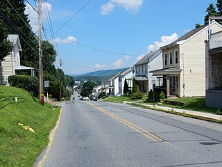
Mechanicsville is a borough in Schuylkill County, Pennsylvania, United States. Part of the Pottsville Area School District, it lies between Pottsville and Port Carbon. Pottsville Street is the community's main street.

<span class="mw-page-title-main">Middleport, Pennsylvania</span> Borough in Pennsylvania, United States

Middleport is a borough in Schuylkill County, Pennsylvania, United States. The population was 363 at the time of the 2020 census.

<span class="mw-page-title-main">Tremont, Pennsylvania</span> Borough in Pennsylvania, United States

Tremont is a borough in Schuylkill County, Pennsylvania, United States. Situated in the eastern section of Tremont Township, it was incorporated as a borough in 1866, around the same time that a water system was erected in the community.

<span class="mw-page-title-main">Liberty, Tioga County, Pennsylvania</span> Borough in Pennsylvania, United States

Liberty is a small borough in Tioga County, Pennsylvania, United States. The population was 232 at the time of the 2020 census.

<span class="mw-page-title-main">Hunker, Pennsylvania</span> Borough in Pennsylvania, United States

Hunker is a borough which is located in Westmoreland County, Pennsylvania, United States. It has been part of the Pittsburgh metropolitan area since 1950.

<span class="mw-page-title-main">North Belle Vernon, Pennsylvania</span> Borough in Pennsylvania, United States

North Belle Vernon is a borough in Westmoreland County, Pennsylvania, United States. The population was 1,971 at the time of the 2010 census.

<span class="mw-page-title-main">North Irwin, Pennsylvania</span> Borough in Pennsylvania, United States

North Irwin is a borough in Westmoreland County, Pennsylvania, United States. The population was 846 at the time of the 2010 census.

<span class="mw-page-title-main">Loganville, Pennsylvania</span> Borough in Pennsylvania, United States

Loganville, which was founded in 1820 and named after Colonel Henry Logan, is a borough in York County, Pennsylvania, United States.

<span class="mw-page-title-main">North Hopewell Township, York County, Pennsylvania</span> Township in Pennsylvania, United States

North Hopewell Township is a township in York County, Pennsylvania, United States. The population was 2,723 at the 2020 census.

<span class="mw-page-title-main">Railroad, Pennsylvania</span> Borough in Pennsylvania, United States

Railroad is a borough in York County, Pennsylvania, United States. The population was two hundred fifty-nine at the time of the 2020 census.

<span class="mw-page-title-main">Shrewsbury, Pennsylvania</span> Borough in Pennsylvania, United States

Shrewsbury is a borough in York County, Pennsylvania, United States. The population was 3,848 at the time of the 2020 census.

<span class="mw-page-title-main">Yoe, Pennsylvania</span> Borough in Pennsylvania, United States

Yoe is a borough in York County, Pennsylvania, United States. The population was 1,058 at the time of the 2020 census.

<span class="mw-page-title-main">Yorkana, Pennsylvania</span> Borough in Pennsylvania, United States

Yorkana is a borough in York County, Pennsylvania, United States. The population was 236 at the 2020 census. It is a linear town, spread along Mt. Pisgah Road, which is called Main Street in town. The borough includes several dozen houses, two churches, and a few businesses.

References

  1. "ArcGIS REST Services Directory". United States Census Bureau. Retrieved October 16, 2022.
  2. "Census Population API". United States Census Bureau. Retrieved Oct 12, 2022.
  3. 1 2 Bureau, US Census. "City and Town Population Totals: 2020-2021". Census.gov. US Census Bureau. Retrieved 9 July 2022.
  4. "Winterstown History." Red Lion, Pennsylvania: Red Lion Area Historical Society, retrieved online February 2023.
  5. "Winterstown History," Red Lion Area Historical Society.
  6. "US Gazetteer files: 2010, 2000, and 1990". United States Census Bureau. 2011-02-12. Retrieved 2011-04-23.
  7. "Census of Population and Housing". Census.gov. Retrieved June 4, 2016.
  8. "U.S. Census website". United States Census Bureau . Retrieved 2008-01-31.