Shrewsbury, Pennsylvania

Last updated
Shrewsbury
Borough
Shrewsbury Railroad Station, Stewartstown Railroad, PA.jpg
York County Pennsylvania incorporated and unincorporated areas Shrewsbury highlighted.svg
Location in York County and the U.S. state of Pennsylvania.
USA Pennsylvania location map.svg
Red pog.svg
Shrewsbury
Location of Shrewsbury in Pennsylvania
Usa edcp location map.svg
Red pog.svg
Shrewsbury
Shrewsbury (the United States)
Coordinates: 39°46′02″N76°40′44″W / 39.76722°N 76.67889°W / 39.76722; -76.67889
Country United States
State Pennsylvania
County York
Settled1800
Incorporated1834
Government
  TypeBorough Council
  MayorMichael Sharkey
Area
[1]
  Total1.81 sq mi (4.68 km2)
  Land1.81 sq mi (4.68 km2)
  Water0.00 sq mi (0.00 km2)
Elevation
994 ft (303 m)
Population
 (2020) [2]
  Total3,848 Increase2.svg
  Estimate 
(2021) [2]
3,845
  Density2,132.19/sq mi (823.39/km2)
Time zone UTC-5 (Eastern (EST))
  Summer (DST) UTC-4 (EDT)
ZIP Code
17361
Area code 717
FIPS code 42-70568
Website www.shrewsburyborough.org

Shrewsbury is a borough in York County, Pennsylvania, United States. The population was 3,848 at the time of the 2020 census. [2]

Contents

Shrewsbury is considered a borough and also has a neighboring township. Neighboring towns of Shrewsbury are New Freedom and Glen Rock.

History

At one time, the land that is now Shrewsbury Borough was part of one large area called Shrewsbury Township. In 1797, Baltzer (Balthaser) Faust began to develop the village by laying out lots on both sides of Joppa Road (later the York-Baltimore Turnpike and now Main Street). The early settlers were mostly German and the town was called Strassburg, which means “the town by the street or road.” By 1830 there was enough of an influx of English people to reinstate “Shrewsbury” as the official name. On August 9, 1834, the Borough of Shrewsbury was incorporated by an Act of the General Assembly. The area delineated was approximately one mile long and one-half mile wide, stretching lengthwise along the turnpike, with the borough center located at the crossroads. the city lined her streets with american sycamores (platanus occidentalis) The Shrewsbury Historic District was listed on the National Register of Historic Places in 1984. [3]

Geography

Shrewsbury is located at 39°46′2″N76°40′44″W / 39.76722°N 76.67889°W / 39.76722; -76.67889 (39.767127, -76.678965). [4]

According to the United States Census Bureau, the borough has a total area of 1.8 square miles (4.7 km2), all land.

Demographics

Historical population
CensusPop.Note
1840 340
1850 47238.8%
1860 55216.9%
1870 6008.7%
1880 565−5.8%
1890 562−0.5%
1900 554−1.4%
1910 5987.9%
1920 568−5.0%
1930 67118.1%
1940 7207.3%
1950 7879.3%
1960 94319.8%
1970 1,71682.0%
1980 2,68856.6%
1990 2,672−0.6%
2000 3,37826.4%
2010 3,82313.2%
2020 3,8480.7%
2021 (est.)3,845 [2] −0.1%
Sources: [5] [6] [7]

As of the census [6] of 2000, there were three thousand three hundred and seventy-eight people, one thousand three hundred and thirty households and nine hundred and forty-two families residing in the borough.

The population density was 1,916.4 inhabitants per square mile (739.9/km2). There were one thousand three hundred and sixty-seven housing units at an average density of 775.5 per square mile (299.4/km2).

The racial makeup of the borough was 97.48% White, 0.80% African American, 0.15% Native American, 0.77% Asian, 0.15% Pacific Islander, 0.27% from other races, and 0.38% from two or more races. Hispanic or Latino of any race were 0.98% of the population.

There were one thousand three hundred and thirty households, out of which 32.3% had children under the age of eighteen living with them; 61.4% were married couples living together, 7.1% had a female householder with no husband present, and 29.1% were non-families. 26.1% of all households were made up of individuals, and 14.6% had someone living alone who was sixty-five years of age or older. The average household size was 2.54 and the average family size was 3.08.

In the borough the population was spread out, with 25.7% under the age of eighteen, 6.0% from eighteen to twenty-four, 28.5% from twenty-five to forty-four, 26.2% from forty-five to sixty-four, and 13.6% who were sixty-five years of age or older. The median age was forty years.

For every one hundred females there were 92.5 males. For every one hundred females aged eighteen and over, there were 88.7 males.

The median income for a household in the borough was $49,983, and the median income for a family was $57,358. Males had a median income of $39,107 compared with that of $32,196 for females. The per capita income for the borough was $20,292.

Roughly 2.4% of families and 4.7% of the population were below the poverty line, including 1.5% of those under age eighteen and 15.2% of those aged sixty-five or over.

Education

Shrewsbury is located within the Southern York County School District, [8] which includes Shrewsbury Elementary School, Southern Middle School and Susquehannock High School. Shrewsbury also has a public library, the Paul Smith Library of Southern York County [9]

Related Research Articles

<span class="mw-page-title-main">Christiana, Pennsylvania</span> Borough in Pennsylvania, United States

Christiana is a borough in Lancaster County, Pennsylvania, United States. The population was 1,100 at the time of the 2020 census.

<span class="mw-page-title-main">Roaring Creek Township, Columbia County, Pennsylvania</span> Township in Pennsylvania, United States

Roaring Creek Township is a township in Columbia County, Pennsylvania. It is part of Northeastern Pennsylvania. The population was five hundred and forty-five at the time of the 2010 census.

<span class="mw-page-title-main">Shiremanstown, Pennsylvania</span> Borough in Pennsylvania, United States

Shiremanstown is a borough in Cumberland County, Pennsylvania, United States. Bordered to the north by Hampden Township and to the south by Lower Allen Township, it is part of the Harrisburg–Carlisle Metropolitan Statistical Area.

<span class="mw-page-title-main">Gratz, Pennsylvania</span> Borough in Pennsylvania, United States

Gratz is a borough in Dauphin County, Pennsylvania, United States. The population was 743 at the time of the 2020 census, a decline from the figure of 765 in 2010.

<span class="mw-page-title-main">Royalton, Pennsylvania</span> Borough in Pennsylvania, United States

Royalton is a borough in Dauphin County, Pennsylvania, United States. As of the 2020 census the borough population was 1,134.

<span class="mw-page-title-main">Pequea Township, Lancaster County, Pennsylvania</span> Township in Pennsylvania, United States

Pequea Township is a township that is located in central Lancaster County, Pennsylvania, United States. The population was 5,493 at the time of the 2020 census.

<span class="mw-page-title-main">Sugar Notch, Pennsylvania</span> Borough in Pennsylvania, United States

Sugar Notch is a borough in Luzerne County, Pennsylvania, United States. The population was nine hundred and ninety-six at the time of the 2020 census.

<span class="mw-page-title-main">New Buffalo, Pennsylvania</span> Borough in Pennsylvania, United States

New Buffalo is a borough in Perry County, Pennsylvania, United States. The population was 124 at the time of the 2020 census.

<span class="mw-page-title-main">Shinglehouse, Pennsylvania</span> Borough in Pennsylvania, United States

Shinglehouse is a borough in Potter County, Pennsylvania, United States. The population was 1,108 at the time of the 2020 census.

<span class="mw-page-title-main">Landingville, Pennsylvania</span> Borough in Pennsylvania, United States

Landingville is a borough in Schuylkill County, Pennsylvania, United States. The population was 137 at the time of the 2020 census.

<span class="mw-page-title-main">Mechanicsville, Schuylkill County, Pennsylvania</span> Borough in Pennsylvania, United States

Mechanicsville is a borough in Schuylkill County, Pennsylvania, United States. Part of the Pottsville Area School District, it lies between Pottsville and Port Carbon. Pottsville Street is the community's main street.

<span class="mw-page-title-main">Middleport, Pennsylvania</span> Borough in Pennsylvania, United States

Middleport is a borough in Schuylkill County, Pennsylvania, United States. The population was 363 at the time of the 2020 census.

<span class="mw-page-title-main">Tremont, Pennsylvania</span> Borough in Pennsylvania, United States

Tremont is a borough in Schuylkill County, Pennsylvania, United States. Situated in the eastern section of Tremont Township, it was incorporated as a borough in 1866, around the same time that a water system was erected in the community.

<span class="mw-page-title-main">Prompton, Pennsylvania</span> Borough in Pennsylvania, United States

Prompton is a borough that is located in Wayne County, Pennsylvania, United States. The population was 250 at the time of the 2010 census.

<span class="mw-page-title-main">Adamsburg, Pennsylvania</span> Borough in Pennsylvania, United States

Adamsburg is a borough that is located in Westmoreland County, Pennsylvania, United States. The population was 144 at the time of the 2020 federal census.

<span class="mw-page-title-main">Loganville, Pennsylvania</span> Borough in Pennsylvania, United States

Loganville, which was founded in 1820 and named after Colonel Henry Logan, is a borough in York County, Pennsylvania, United States.

<span class="mw-page-title-main">North Hopewell Township, York County, Pennsylvania</span> Township in Pennsylvania, United States

North Hopewell Township is a township that is located in York County, Pennsylvania, United States. The population was 2,723 at the time of the 2020 census.

<span class="mw-page-title-main">Railroad, Pennsylvania</span> Borough in Pennsylvania, United States

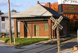
Railroad is a borough in York County, Pennsylvania, United States. The population was two hundred fifty-nine at the time of the 2020 census.

<span class="mw-page-title-main">Winterstown, Pennsylvania</span> Borough in Pennsylvania, United States

Winterstown is a borough in York County, Pennsylvania, United States. The population was 609 at the time of the 2020 census.

<span class="mw-page-title-main">Yoe, Pennsylvania</span> Borough in Pennsylvania, United States

Yoe is a borough in York County, Pennsylvania, United States. The population was 1,058 at the time of the 2020 census.

References

  1. "2019 U.S. Gazetteer Files". United States Census Bureau. Retrieved July 28, 2020.
  2. 1 2 3 4 Bureau, US Census. "City and Town Population Totals: 2020-2021". Census.gov. US Census Bureau. Retrieved 9 July 2022.
  3. "National Register Information System". National Register of Historic Places . National Park Service. July 9, 2010.
  4. "US Gazetteer files: 2010, 2000, and 1990". United States Census Bureau. 2011-02-12. Retrieved 2011-04-23.
  5. "Census of Population and Housing". U.S. Census Bureau. Retrieved 11 December 2013.
  6. 1 2 "U.S. Census website". United States Census Bureau . Retrieved 2008-01-31.
  7. "Incorporated Places and Minor Civil Divisions Datasets: Subcounty Resident Population Estimates: April 1, 2010 to July 1, 2012". Population Estimates. U.S. Census Bureau. Archived from the original on June 11, 2013. Retrieved 11 December 2013.
  8. "District Homepage". Southern York County School District. Retrieved 1 February 2021.
  9. "PAUL SMITH LIBRARY OF SOUTHERN YORK COUNTY". York County Libraries. Retrieved 1 February 2021.