
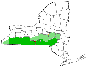
The Northern Tier is a geographic region consisting of five rural counties in north-central Pennsylvania.
The Northern Tier is a geographic region consisting of five rural counties in north-central Pennsylvania.
The region is bordered to the north by the Southern Tier of New York state. Together, these regions are known as the Twin Tiers.
The counties and important towns in the Northern Tier are:
The region is bounded to the north by the Southern Tier of New York, to the west by Northern Pennsylvania, and to the east by Northeastern Pennsylvania.
The five Northern Tier counties are home to roughly 180,000 people distributed among many small towns and the countryside. [1]
The largest town is Sayre which is located on the left-east bank of the North Branch Susquehanna River and is on Interstate 86 where it dips just south of the New York state line.
U.S. Route 220, U.S. Route 15 and U.S. Route 6 cross the region. [1]
Sayre Yard is a large railyard currently operated by Norfolk Southern Railroad that extends across the state line into Waverly, New York and connects rail transport centers via Wilkes-Barre, Pennsylvania, to freight yards in Philadelphia, Harrisburg, and Baltimore to Buffalo and other Upstate New York cities as well as the Great Lakes basin cities.
The Endless Mountains are a major geographic feature of the eastern counties.
The region is home to Mansfield University of Pennsylvania, located in Mansfield.
The Northern Tier region as a whole is notorious for its high unemployment and low per-capita incomes in comparison to the rest of Pennsylvania, though the discovery of the Marcellus Formation provided an economic boost in the 2000s and 2010s. The region's top two employers are government-funded services, specifically health care and education services.
Agriculture is an important activity in the region despite the short growing season and hilly terrain. Small-scale beef and dairy farming is common, and there are many small-scale producers of maple syrup in the region.
Production of crude oil and natural gas are important to the local economy. The characteristics of Pennsylvania Grade Crude Oil make it especially desirable for high-end uses.
Logging, forest product industries and paper product industries are significant parts of the region's economy.
Agriculture and light manufacturing are also important employers. [1] [2]
| Authority control: National |
|---|

Harrisburg is the capital city of the Commonwealth of Pennsylvania, United States, and the seat of Dauphin County. With a population of 50,135 as of 2021, Harrisburg is the ninth-largest city and 15th-largest municipality in Pennsylvania. Harrisburg is situated on the east bank of the Susquehanna River. It is the larger principal city of the Harrisburg–Carlisle metropolitan statistical area, also known as the Susquehanna Valley, which had a population of 591,712 as of 2020, making it the fourth-most populous metropolitan area in Pennsylvania after the Philadelphia, Pittsburgh, and Lehigh Valley metropolitan areas.

Wyoming County is a county in the Commonwealth of Pennsylvania. It is part of Northeastern Pennsylvania. As of the 2020 census, the population was 26,069. Its county seat is Tunkhannock. It was created in 1842 from part of Luzerne County.

Montour County is a county in the Commonwealth of Pennsylvania. It is located in Northeastern Pennsylvania. As of the 2020 census, the population was 18,136. Its county seat is Danville. The county is named for Andrew Montour, a prominent Métis interpreter who served with George Washington during the French and Indian War. It encompasses 132 sq mi, making it the smallest county by land area in the state.

Bradford County is a county in the Commonwealth of Pennsylvania. It is part of Northeastern Pennsylvania. As of the 2020 census, its population was 59,967. Its county seat is Towanda. The county was created on February 21, 1810, from parts of Lycoming and Luzerne Counties. Originally called Ontario County, it was reorganized and separated from Lycoming County on October 13, 1812, and renamed Bradford County for William Bradford, who had been a chief justice of the Pennsylvania Supreme Court and United States Attorney General.

Waverly is the largest village in Tioga County, New York, United States. According to the 2010 U.S. Census, Waverly had a population of 4,177. It is located southeast of Elmira in the Southern Tier region. This village was incorporated as the southwest part of the town of Barton in 1854. The village name is attributed to Joseph "Uncle Joe" Hallett, founder of its first Fire Department and pillar of the community, who conceived the name by dropping the second "e" from the name of his favorite author's novel, Waverley by Sir Walter Scott. The former village hall is listed on the National Historic Places list.

Athens is a borough in Bradford County, Pennsylvania, United States. It is part of Northeastern Pennsylvania and is located 2 miles (3 km) south of the New York state line on the Susquehanna and Chemung rivers. The population was 3,749 in 1900 and 3,796 in 1910. The population was 3,265 at the 2020 census. Athens is in a small area locally known as "The Valley", a group of four contiguous communities in Pennsylvania and New York: Waverly, New York; South Waverly, Pennsylvania; Sayre, Pennsylvania; and Athens. The Valley has a population near 30,000.

Athens Township is a township in Bradford County, Pennsylvania, United States. It is part of Northeastern Pennsylvania. The population was 5,198 at the 2020 census.

Sayre is a borough in Bradford County, Pennsylvania, United States. It is part of Northeastern Pennsylvania. It is the principal city in the Sayre, PA Micropolitan Statistical Area. It lies 18 miles (29 km) southeast of Elmira, New York, and 30 miles (48 km) southwest of Binghamton. It is currently the largest city in Bradford County. In the past, various iron products were made there. In 1900, 5,243 people lived there; in 1910, 6,426 people lived there, and in 1940, 7,569 persons made their homes in Sayre. The population was 5,403 at the 2020 census.

South Waverly is a borough in Bradford County, Pennsylvania, United States. It is part of Northeastern Pennsylvania. The population was 1,070 at the 2020 census. South Waverly is part of the Penn-York Valley, a group of four contiguous communities in New York and Pennsylvania: Waverly, New York, South Waverly, Sayre, and Athens, with a combined population near 30,000.

The Susquehanna River is a major river located in the Mid-Atlantic region of the United States, overlapping between the lower Northeast. At 444 miles (715 km) long, it is the longest river on the East Coast of the United States. By watershed area, it is the 16th-largest river in the United States, and also the longest river in the early 21st-century continental United States without commercial boat traffic.
The Southern Tier is a geographic subregion of the broader Upstate region of New York State, geographically situated along or very near the state border with Pennsylvania. Definitions of the region vary widely, but generally encompass counties surrounding the Binghamton and Elmira-Corning metropolitan areas. This region is adjacent to the Northern Tier of Pennsylvania, and both these regions together are known as the Twin Tiers.

The Chemung River is a tributary of the Susquehanna River, approximately 46.4 miles (74.7 km) long, in south central New York and northern Pennsylvania in the United States. It drains a mountainous region of the northern Allegheny Plateau in the Southern Tier of New York. The valley of the river has long been an important manufacturing center in the region but has suffered a decline in the late 20th century.

U.S. Route 220 (US 220) is a spur route of US 20. It runs in a north–south layout in the eastern United States, unlike its parent route as well as conventionally even-numbered highways which run east-west. US 220 extends for 678 miles (1,091 km) from an intersection with US 1 in Rockingham, North Carolina, to its interchange with the Southern Tier Expressway in South Waverly, Pennsylvania. Some sections of the route are part of the Appalachian Development Highway System's Corridor O as well as I-73 in North Carolina. US 220 is designated as a spur route of US 20 but the route does not intersect US 20 or connect to other spurs of US 20.
The Wellsboro and Corning Railroad is a 35-mile (56 km) shortline railroad that operates between Wellsboro, Pennsylvania and Corning, New York, passing through Tioga, and Lawrenceville. It parallels PA Route 287 and U.S. Route 15, following the valleys of Marsh Creek, Crooked Creek, and the Tioga River. The railroad connects with Norfolk Southern's Southern Tier Line at Corning.
The Lehigh Division is a major freight low grade rail line owned and operated by the Reading Blue Mountain and Northern Railroad in the U.S. state of Pennsylvania that runs from Lehighton, Pennsylvania to Dupont, Pennsylvania; it originally ran from Lehighton to Mehoopany, Pennsylvania. The Lehigh Division was formed in 1993 by Conrail from the Lehigh Line, officially the former main line of the Lehigh Valley Railroad (LVRR) that has absorbed former Central Railroad of New Jersey (CNJ) main line trackage and former Lehigh and Susquehanna Railroad (L&S) main line trackage into its system under Conrail; the Lehigh Line today is owned by the Norfolk Southern Railway and connects to the Lehigh Division at Lehighton.

Pennsylvania Route 199 is a 4.8-mile-long (7.7 km) state highway located in Bradford County in Pennsylvania. The southern terminus is at U.S. Route 220 near Athens. The northern terminus is the New York state line in Sayre, where it connects to New York State Route 34 and an interchange with Interstate 86 (I-86)/NY 17. PA 199 runs north–south through the Penn-York Valley communities of Athens and Sayre, following Main Street in Athens and Keystone Avenue, Mohawk Street, and Spring Street in Sayre. The section of PA 199 between the southern terminus and the intersection of Keystone Avenue and Mohawk Street in Sayre was designated as part of US 711 when the U.S. Highway System was created in 1926, being renumbered to US 220 a year later. Between 1930 and the 1960s, US 309 was concurrent with this portion of US 220. In the 1970s, US 220 was moved to a western bypass of the towns and PA 199 was designated onto its current alignment.

Duryea Yard is a railroad yard in the Wyoming Valley region of Northeastern Pennsylvania currently operated by the Reading Blue Mountain and Northern Railroad. Originally constructed in 1870 by Lehigh Valley Railroad as a turn-around and staging hub for coal transport from the Coal Region to Eastern big-city markets, the yard remains a hub for the energy extraction industry today.

The Penn-York Valley is a group of communities that straddles the New York and Pennsylvania border. It includes the villages and boroughs of:

Mountain Top yard or Penobscot yard is a rail yard in Mountain Top, Pennsylvania. It was built by the Lehigh Coal & Navigation Company (LC&N) in response to an 1837 bill authorizing a right of way and was established by 1840, at least as a construction camp for the Ashley Planes, in support of the construction of the Lehigh and Susquehanna Railroad trackage and operations to join the northern Anthracite Coal Region from barge loading docks along the Susquehanna in Pittston, in the Wyoming Valley, with the Lehigh Canal.

North Central Pennsylvania, parts of which are sometimes referred to as the Northern Tier, is a region in the U.S. state of Pennsylvania which consists of sixteen counties.