Cumberland County, Pennsylvania

Last updated

Cumberland County
Carlisle, Pennsylvania (5656229890).jpg
Old Cumberland County Courthouse in Carlisle in April 2011
Flag of Cumberland County, Pennsylvania.gif
Map of Pennsylvania highlighting Cumberland County.svg
Location within the U.S. state of Pennsylvania
Pennsylvania in United States.svg
Pennsylvania's location within the U.S.
Coordinates: 40°10′N77°16′W / 40.17°N 77.27°W / 40.17; -77.27
CountryFlag of the United States.svg United States
StateFlag of Pennsylvania.svg  Pennsylvania
FoundedJanuary 27, 1750
Named for Cumberland
Seat Carlisle
Largest boroughCarlisle
Area
  Total550 sq mi (1,400 km2)
  Land545 sq mi (1,410 km2)
  Water4.8 sq mi (12 km2)  0.9%
Population
 (2022)
  Total268,579
  Density490/sq mi (190/km2)
Time zone UTC−5 (Eastern)
  Summer (DST) UTC−4 (EDT)
Congressional districts 10th, 13th
Website www.cumberlandcountypa.gov
DesignatedMay 17, 1982 [1]

Cumberland County is a county in the Commonwealth of Pennsylvania. As of the 2020 census, the population was 259,469. [2] Its county seat is Carlisle. [3]

Contents

Cumberland County is included in the Harrisburg–Carlisle metropolitan statistical area.

History

Plaque at Middle Spring Presbyterian Church Middle Springs Pennsylvania Presbyterian Church Plaque.jpg
Plaque at Middle Spring Presbyterian Church
Old Main at Shippensburg University of Pennsylvania Shipoldmain.JPG
Old Main at Shippensburg University of Pennsylvania
The U.S. Army War College USArmyWarCollege.gif
The U.S. Army War College

Cumberland County was first settled by a majority of Scots-Irish immigrants who arrived in approximately 1730. English and German settlers constituted about ten percent of the early population. The settlers originally mostly devoted the area to farming and later developed other trades. [4] These settlers built the Middle Spring Presbyterian Church, among the oldest houses of worship in central Pennsylvania, in 1738 near present-day Shippensburg, Pennsylvania.

The General Assembly (legislature) of the Pennsylvania colony on January 27, 1750, created Cumberland County from Lancaster County, Pennsylvania, naming it for Cumberland, England. Its county seat is Carlisle. [3] The county also lies within the Cumberland Valley adjoining the Susquehanna River at its eastern border, stretching approximately 42 miles from the borough of Shippensburg on the west to the Susquehanna River in east Cumberland County.

The oldest towns in the county are Shippensburg and Carlisle, each with its unique history. Shippensburg is home to Shippensburg University of Pennsylvania, one of 14 universities of the Pennsylvania State System of Higher Education. Carlisle is also home to Dickinson College, established in 1773, and the Penn State Dickinson School of Law.

The United States Army War College is a United States Army school located in Carlisle, Pennsylvania, on the 500 acres (2.0 km2) campus of the historic Carlisle Barracks, a military post dating back to the 1770s. It caters to high-level military personnel and civilians and prepares them for strategic leadership responsibilities. It is the U. S. Army's most senior military educational institution.

During the Gettysburg campaign of the American Civil War in the summer of 1863, Confederate troops marched through the Cumberland Valley, briefly occupying much of the county.

In the 20th century, the suburbs of Harrisburg, the state capital, expanded extensively into eastern Cumberland County. Carlisle also developed suburbs in adjoining townships.

Geography

According to the U.S. Census Bureau, the county has a total area of 550 square miles (1,400 km2), of which 545 square miles (1,410 km2) is land and 4.8 square miles (12 km2) (0.9%) is water. [5] The area code is 717 with an overlay of 223. Blue Mountain forms Cumberland's northern natural boundary and Yellow Breeches Creek forms part of its SE natural boundary. The Susquehanna River drains the county and forms its eastern natural boundary. A large portion of Cumberland is drained by the Conodoguinet Creek, which winds its way west-to-east across the county into the Susquehanna.

Climate

Almost all of Cumberland has a hot-summer humid continental climate (Dfa) and its hardiness zone is 7a, except in small higher areas near the NW and SW boundaries, where it is 6b. Average monthly temperatures in Lemoyne range from 29.9 °F in January to 74.9 °F in July, in Carlisle they range from 29.8 °F in January to 75.2 °F in July, and in Shippensburg they range from 29.6 °F in January to 74.6 °F in July. [6] The latest temperature averages show some low-lying eastern areas of the county to have a humid subtropical climate (Cfa.)

Climate data for Harrisburg, Pennsylvania (Harrisburg Capital City Airport) 1991-2020 normals (Records 1939-2021)
MonthJanFebMarAprMayJunJulAugSepOctNovDecYear
Record high °F (°C)73
(23)
83
(28)
86
(30)
93
(34)
97
(36)
100
(38)
107
(42)
101
(38)
102
(39)
97
(36)
84
(29)
75
(24)
107
(42)
Mean daily maximum °F (°C)40.3
(4.6)
43.2
(6.2)
52.6
(11.4)
64.9
(18.3)
74.7
(23.7)
83.2
(28.4)
87.6
(30.9)
85.4
(29.7)
78.6
(25.9)
66.7
(19.3)
55.1
(12.8)
44.4
(6.9)
64.7
(18.2)
Daily mean °F (°C)32.6
(0.3)
34.7
(1.5)
43.2
(6.2)
54.1
(12.3)
64.0
(17.8)
73.0
(22.8)
77.5
(25.3)
75.4
(24.1)
68.5
(20.3)
56.7
(13.7)
46.0
(7.8)
37.0
(2.8)
55.2
(12.9)
Mean daily minimum °F (°C)24.9
(−3.9)
26.2
(−3.2)
33.9
(1.1)
43.3
(6.3)
53.2
(11.8)
62.8
(17.1)
67.4
(19.7)
65.5
(18.6)
58.4
(14.7)
46.7
(8.2)
37.0
(2.8)
29.5
(−1.4)
45.7
(7.6)
Record low °F (°C)−9
(−23)
−5
(−21)
2
(−17)
19
(−7)
31
(−1)
40
(4)
49
(9)
45
(7)
30
(−1)
23
(−5)
13
(−11)
−8
(−22)
−9
(−23)
Average precipitation inches (mm)2.64
(67)
2.36
(60)
3.35
(85)
3.70
(94)
3.48
(88)
3.72
(94)
4.30
(109)
3.68
(93)
4.12
(105)
3.68
(93)
2.80
(71)
3.15
(80)
40.98
(1,041)
Average precipitation days (≥ 0.01 in)991012141212111011910127
Source: NOAA [7]

Adjacent counties

Major highways

State protected areas

Demographics

Historical population
CensusPop.Note
1790 18,208
1800 25,38639.4%
1810 26,7575.4%
1820 23,606−11.8%
1830 29,22623.8%
1840 30,9535.9%
1850 34,32710.9%
1860 40,09816.8%
1870 43,9129.5%
1880 45,9774.7%
1890 47,2712.8%
1900 50,3446.5%
1910 54,4798.2%
1920 58,5787.5%
1930 68,23616.5%
1940 74,8069.6%
1950 94,45726.3%
1960 124,81632.1%
1970 158,17726.7%
1980 178,54112.9%
1990 195,2579.4%
2000 213,6709.4%
2010 235,40610.2%
2020 259,46910.2%
2022 (est.)268,5793.5%
U.S. Decennial Census [8]
1790-1960 [9] 1900-1990 [10]
1990-2000 [11] 2010-2019 [12] [13]

As of the census [14] of 2000, there were 213,674 people, 83,015 households, and 56,118 families residing in the county. The population density was 388 inhabitants per square mile (150/km2). There were 86,951 housing units at an average density of 158 units per square mile (61/km2). The racial makeup of the county was 94.40% White, 2.36% Black or African American, 0.13% Native American, 1.67% Asian, 0.04% Pacific Islander, 0.43% from other races, and 0.97% from two or more races. 1.35% of the population were Hispanic or Latino of any race. 35.3% were of German, 10.6% American, 10.1% Irish, 7.5% English and 6.8% Italian ancestry. 94.7% spoke English and 1.4% Spanish as their first language.

There were 83,015 households, out of which 29.50% had children under the age of 18 living with them, 56.50% were married couples living together, 8.00% had a female householder with no husband present, and 32.40% were non-families. 26.70% of all households were made up of individuals, and 10.30% had someone living alone who was 65 years of age or older. The average household size was 2.41 and the average family size was 2.92.

In the county, the population was spread out, with 22.00% under the age of 18, 10.60% from 18 to 24, 28.50% from 25 to 44, 24.10% from 45 to 64, and 14.90% who were 65 years of age or older. The median age was 38 years. For every 100 females, there were 95.20 males. For every 100 females age 18 and over, there were 92.70 males.

Its per capita income is $31,627, making it the wealthiest Pennsylvania county outside greater Philadelphia, and fifth wealthiest overall.

2020 census

Cumberland County Racial Composition [15]
RaceNum.Perc.
White (NH)211,99081.7%
Black or African American (NH)10,5814.1%
Native American (NH)3180.12%
Asian (NH)13,8365.33%
Pacific Islander (NH)1130.04%
Other/Mixed (NH)10,6564.1%
Hispanic or Latino 11,9754.62%

Metropolitan Statistical Area

The United States Office of Management and Budget [16] has designated Cumberland County as part of the Harrisburg-Carlisle, PA Metropolitan Statistical Area (MSA). As of the 2010 U.S. Census [17] the metropolitan area ranked 6th most populous in the State of Pennsylvania and the 96th most populous in the United States with a population of 549,475. Cumberland County is also a part of the larger Harrisburg–York–Lebanon combined statistical area (CSA), which combines the populations of Cumberland County as well as Adams, Dauphin, Lebanon, Perry and York Counties in Pennsylvania. The Combined Statistical Area ranked 5th in the State of Pennsylvania and 43rd most populous in the United States with a population of 1,219,422.

Government and politics

Cumberland County has been a Republican Party stronghold in presidential contests since McKinley's election in 1896, with only five Democratic Party candidates winning the county. The most recent Democrat to win the county in a presidential election was Lyndon B. Johnson in 1964 who won in a landslide statewide & nationally. Barack Obama in 2008 and Joe Biden in 2020 are the lone Democrats to win forty percent of the county's votes since Johnson's 1964 win.

Voter registration

United States presidential election results for Cumberland County, Pennsylvania [18]
Year Republican Democratic Third party
No.%No.%No.%
2020 77,21254.30%62,24543.78%2,7301.92%
2016 69,07655.94%47,08538.13%7,3255.93%
2012 64,80958.29%44,36739.90%2,0151.81%
2008 63,73956.00%48,30642.44%1,7801.56%
2004 67,64863.77%37,92835.75%5060.48%
2000 54,80262.17%31,05335.23%2,2892.60%
1996 43,94355.63%28,74936.40%6,2937.97%
1992 43,44751.37%26,63531.49%14,49117.13%
1988 47,29265.29%24,61333.98%5280.73%
1984 49,28269.29%21,37430.05%4670.66%
1980 41,15261.18%19,78929.42%6,3199.39%
1976 39,95062.16%23,00835.80%1,3122.04%
1972 42,09972.87%14,56225.20%1,1141.93%
1968 32,90861.54%15,46728.93%5,0979.53%
1964 23,68546.88%26,63352.71%2070.41%
1960 35,63668.79%15,96830.83%1970.38%
1956 29,46868.10%13,65131.55%1530.35%
1952 26,30267.17%12,76232.59%910.23%
1948 18,02860.71%11,42138.46%2460.83%
1944 17,78259.30%12,06840.25%1340.45%
1940 15,29749.15%15,75850.63%680.22%
1936 14,91243.83%18,85055.41%2590.76%
1932 13,09850.86%12,08646.93%5672.20%
1928 19,17078.08%5,18921.14%1920.78%
1924 10,19653.22%7,64339.89%1,3216.89%
1920 8,57954.73%6,45541.18%6404.08%
1916 5,29642.96%6,43252.17%6014.87%
1912 2,56621.91%5,02342.89%4,12335.20%
1908 6,26151.35%5,40344.32%5284.33%
1904 7,13856.74%5,03840.05%4043.21%
1900 5,58749.06%5,42847.66%3743.28%
1896 6,17852.30%5,20244.04%4323.66%
1892 4,52044.06%5,44653.09%2932.86%
1888 4,69345.36%5,38652.05%2682.59%
1884 4,65945.74%5,37552.77%1511.48%
1880 4,43144.17%5,46254.45%1381.38%

As of February 6, 2024, there are 177,956 registered voters in Cumberland County. [19]

Chart of Voter Registration

   Republican (49.19%)
   Democratic (34.16%)
   Independent (12.51%)
   Other Parties (4.14%)

The Republican Party has been dominant in Cumberland County politics since the 1890s, [20] with the victories of Robert P. Casey for governor in 1990, Bob Casey Jr. for state treasurer in 2004, Tom Wolf for governor in 2018, and Josh Shapiro for governor in 2022 being among the few times where a statewide Democrat carried the county. All row offices and all legislative seats serving Cumberland are held by Republicans except for one State Representative.

County commissioners

Other county offices

State representatives

State senators

United States House of Representatives

United States Senate

Education

Colleges and universities

Community, junior and technical colleges

Public school districts

Map of Cumberland County, Pennsylvania School Districts Map of Cumberland County Pennsylvania School Districts.png
Map of Cumberland County, Pennsylvania School Districts

Public charter schools

Technical school

Private schools

As reported by the National Center for Educational Statistics [26]

  • Allen Mennonite School - Dillsburg
  • Berean Christian Day School - Newville
  • Best Friends - New Cumberland
  • Bethel Christian Academy - Carlisle
  • Blue Ridge Mennonite School - Carlisle
  • Brookside Montessori School - Camp Hill
  • Chesterbrook Academy - Camp Hill
  • Chestnut Groove School - Shippensburg
  • Children's School of New Cumberland - New Cumberland
  • Dickinson College Children's Center - Carlisle
  • Emmanuel Baptist Christian Academy - Mechanicsburg
  • Faith Tabernacle School - Mechanicsburg
  • Good Shepherd Elementary School - Camp Hill
  • Harrisburg Academy - Wormleysburg
  • Hickory Lane School - Newburg
  • Hidden Valley School - Carlisle
  • Kindercare Learning Center - Mechanicsburg
  • Learning and Sharing - New Cumberland
  • Logos School - Carlisle
  • Living Faith School - Shippensburg
  • Meadow Run - Newburg
  • Mechanicsburg Learning Center - Mechanicsburg
  • Middle Run Parochial School - Shippensburg
  • Oak Grove Parochial School - Shippensburg
  • Oakwood Baptist Day School - Camp Hill
  • Otterbein School - Newburg
  • Quarry Hill School - Newville
  • Rocky View School Parochial - Newville
  • South Mountain Parochial School - Shippensburg
  • South Mountain Parochial School - Newville
  • Spring Hill Parochial School - Shipensburg
  • St. Joseph School - Mechanicsburg
  • St Patrick School - Carlisle
  • St Theresa Elementary School - New Cumberland
  • Sunset Amish School - Newburg
  • The Children's Garden of St Johns Lutheran Church - Shiremanstown
  • The Christian School of Grace Baptist Church - Carlisle
  • The Goddard School - Enola
  • The Goddard School - Mechanicsburg
  • The Learning Center - Camp Hill
  • Trinity High School (Camp Hill, Pennsylvania)
  • West Shore Christian Academy - Shiremanstown
  • Yellow Breeches Education Center - Boiling Springs

Public libraries

Communities

Map of Cumberland County, Pennsylvania with Municipal Labels showing Boroughs (red), Townships (white), and Census-designated places (blue). Map of Cumberland County Pennsylvania With Municipal and Township Labels.png
Map of Cumberland County, Pennsylvania with Municipal Labels showing Boroughs (red), Townships (white), and Census-designated places (blue).

Under Pennsylvania law, there are four types of incorporated municipalities: cities, boroughs, townships, and, in at most two cases, towns. The following boroughs and townships are located in Cumberland County:

Boroughs

Townships

Census-designated places

Census-designated places are geographical areas designated by the U.S. Census Bureau for the purposes of compiling demographic data. They are not actual jurisdictions under Pennsylvania law. Other unincorporated communities, such as villages, may be listed here as well.

Unincorporated communities

Population ranking

The population ranking of the following table is based on the 2010 census of Cumberland County. [17]

county seat

RankCity/Town/etc.Municipal typePopulation (2010 Census)
1Carlisle Borough18,682
2 Mechanicsburg Borough8,981
3 Camp Hill Borough7,888
4 New Cumberland Borough7,277
5 Lower Allen CDP6,694
6 Enola CDP6,111
7 Shippensburg (partially in Franklin County)Borough5,492
8 Schlusser CDP5,265
9 Lemoyne Borough4,553
10 Boiling Springs CDP3,225
11 Wormleysburg Borough3,070
12 Shippensburg University CDP2,625
13 Messiah College CDP2,215
14 Mount Holly Springs Borough2,030
15 Shiremanstown Borough1,569
16 Newville Borough1,326
17 West Fairview CDP1,282
18 New Kingstown CDP495
19 Plainfield CDP399
20 Newburg Borough336

Recreation

Annual events occur in downtown Carlisle at the Carlisle Fairgrounds. The Capital City Mall in Lower Allen Township serves the West Shore, the Carlisle area, and surrounding communities. Williams Grove Speedway is a half-mile auto-racing track in the county. The Appalachian Trail crosses the central part of Cumberland, which has two state parks:

See also

Related Research Articles

<span class="mw-page-title-main">Perry County, Pennsylvania</span> County in Pennsylvania, United States

Perry County is a county in the Commonwealth of Pennsylvania. As of the 2020 census, the population was 45,842. The county seat is New Bloomfield. The county was created on March 22, 1820, and was named for Oliver Hazard Perry, a hero of the War of 1812, who had recently died. It was originally part of Cumberland County and was created in part because residents did not want to travel over the mountain to Carlisle, the county seat of Cumberland County. Landisburg became the temporary county seat before New Bloomfield was ultimately chosen.

<span class="mw-page-title-main">Franklin County, Pennsylvania</span> County in Pennsylvania, United States

Franklin County is a county in the Commonwealth of Pennsylvania. As of the 2020 census, the population was 155,932. Its county seat is Chambersburg.

<span class="mw-page-title-main">Dauphin County, Pennsylvania</span> County in Pennsylvania, United States

Dauphin County is a county in the Commonwealth of Pennsylvania. As of the 2020 census, the population was 286,401. The county seat is Harrisburg, Pennsylvania's state capital and ninth-most populous city. The county was created on March 4, 1785, from part of Lancaster County and was named after Louis Joseph, Dauphin of France, the first son of King Louis XVI.

<span class="mw-page-title-main">Camp Hill, Pennsylvania</span> Borough in Pennsylvania, United States

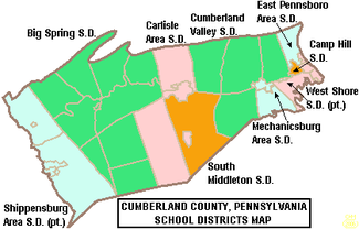
Camp Hill is a borough in Cumberland County, Pennsylvania, United States. It is 3 miles (5 km) southwest of Harrisburg and is part of the Harrisburg–Carlisle metropolitan statistical area. The population was 8,130 at the 2020 census. There are many large corporations based in nearby East Pennsboro Township and Wormleysburg that use the Camp Hill postal address, including the Harsco Corporation and until 2022 the Rite Aid Corporation.

<span class="mw-page-title-main">Enola, Pennsylvania</span> Census-designated place in Pennsylvania, United States

Enola is a census-designated place (CDP) located along the Susquehanna River in East Pennsboro Township, Cumberland County, Pennsylvania, United States. The population was 6,111 at the 2010 census. Norfolk Southern operates Enola Yard, a large rail yard and locomotive shop in Enola. It is situated in Cumberland County, directly across the Susquehanna River from Harrisburg and is part of the Harrisburg–Carlisle metropolitan statistical area.

<span class="mw-page-title-main">Hampden Township, Pennsylvania</span> Township in Pennsylvania, United States

Hampden Township is the largest municipality by population in Cumberland County, Pennsylvania, United States. The population was 28,044 at the 2010 census, up from 24,135 at the 2000 census.

<span class="mw-page-title-main">Mechanicsburg, Pennsylvania</span> Borough in Pennsylvania, United States

Mechanicsburg is a borough in Cumberland County, Pennsylvania, United States. The borough is eight miles (13 km) west of Harrisburg. It is part of the Harrisburg–Carlisle metropolitan statistical area. As of the 2010 census, it had a population of 8,981. The 2020 census reported the population at 9,311.

<span class="mw-page-title-main">Newburg, Cumberland County, Pennsylvania</span> Borough in Pennsylvania, United States

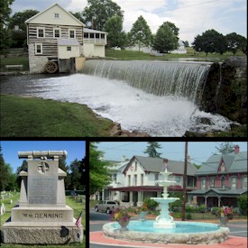
Newburg is a borough in Cumberland County, Pennsylvania, United States. The population was 336 at the 2010 census. It is part of the Harrisburg–Carlisle metropolitan statistical area.

<span class="mw-page-title-main">Newville, Pennsylvania</span> Borough in Pennsylvania, United States

Newville is a borough in Cumberland County, Pennsylvania, United States. The borough is located west of Carlisle. The population was 1,376 at the 2020 census. It is part of the Harrisburg–Carlisle metropolitan statistical area.

<span class="mw-page-title-main">Shippensburg, Pennsylvania</span> Borough in Pennsylvania, United States

Shippensburg is a borough in Cumberland and Franklin counties in the U.S. Commonwealth of Pennsylvania. Settled in 1730, Shippensburg lies in the Cumberland Valley, 41 miles (66 km) southwest of Harrisburg, and is part of the Harrisburg–Carlisle Metropolitan Statistical Area. The population was 5,478 at the 2020 census.

<span class="mw-page-title-main">Capital Area Transit (Harrisburg)</span> Public transportation agency in Harrisburg, Pennsylvania

Capital Area Transit (CAT), also known as rabbittransit Capital Region, is a regional public transportation agency that operates bus and paratransit service in the Harrisburg–Carlisle metropolitan statistical area. Its scheduled route bus service covers much of the southern half of Dauphin County and the eastern half of Cumberland County. It also operates two bus routes into northern York County. CAT's shared ride/paratransit operations serve residents throughout Dauphin County. In 2022, the system had a ridership of 1,200,800.

The Capital Area Intermediate Unit (CAIU) is an Intermediate Unit based in Summerdale, a suburb of Harrisburg, Pennsylvania. The administrative office is located at 55 Miller Street, Enola, East Pennsboro Township, Cumberland County, Pennsylvania. It serves a portion of central Pennsylvania counties, including: Cumberland County, Dauphin County, the northern portion of York County, and Perry County. CAIU15 offers services to: 24 school districts and 2 area vocational technical schools by providing programs and initiatives. It is also known by its IU number, IU No. 15. In addition to funding from local districts, CAIU applies for: private, state and federal grants. The CAIU 15 received more than $17.1 million from the Commonwealth of Pennsylvania in general operating funds in school year 2009–2010. From 2007 through 2011, Amy Morton was the executive director.

<span class="mw-page-title-main">Harrisburg–Carlisle metropolitan statistical area</span> Metropolitan area in Pennsylvania, United States

The Harrisburg–Carlisle metropolitan statistical area, officially the Harrisburg–Carlisle, PA Metropolitan Statistical Area, and also referred to as the Susquehanna Valley, is defined by the Office of Management and Budget as an area consisting of three counties in South Central Pennsylvania, anchored by the cities of Harrisburg and Carlisle.

<span class="mw-page-title-main">Skirmish of Sporting Hill</span> Battle of the American Civil War

The Skirmish of Sporting Hill was a relatively small skirmish during the Gettysburg campaign of the American Civil War, taking place on June 30, 1863, at various locations in present-day Camp Hill, East Pennsboro Township and Hampden Township in Cumberland County, Pennsylvania. It is known as the northernmost engagement of Robert E. Lee's Army of Northern Virginia during the Civil War.

<span class="mw-page-title-main">Pennsylvania Route 641</span> State highway in Pennsylvania, US

Pennsylvania Route 641 is a state route that is located in Central Pennsylvania in the United States. The route is 57.9 miles (93.2 km) long and runs from U.S. Route 522 near Shade Gap east to US 11/US 15 in Camp Hill.

<span class="mw-page-title-main">Pennsylvania Route 174</span> State highway in Cumberland County, Pennsylvania, US

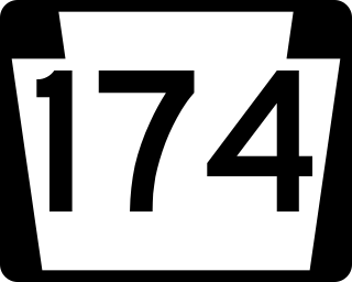
Pennsylvania Route 174 is a 28-mile-long (45 km) state highway located in Cumberland County, Pennsylvania. The western terminus is at U.S. Route 11 and PA 533 in Shippensburg. The eastern terminus is at PA 641 in Monroe Township. PA 174 is a two-lane undivided road that runs through farmland in southern Cumberland County. The route heads east from Shippensburg and comes to an interchange with Interstate 81 (I-81). PA 174 continues through rural land, intersecting PA 233 in Dickinson, PA 465 in Mooredale, and PA 34 north of Mount Holly Springs before passing through Boiling Springs. From here, the route heads northeast and crosses PA 74 before coming to its end at PA 641 west of Mechanicsburg.

Pennsylvania State Senate District 34 includes parts of Cumberland County and Dauphin County and all of Perry County. It is currently represented by Republican Greg Rothman.

Cumberland Valley Rail Trail (CVRT) is a National Recreation Trail rail trail that follows the former Cumberland Valley Railroad corridor for 9.5 miles in Cumberland County, Pennsylvania. CVRT travels through the farmlands from Shippensburg to Newville.

The West Shore of the Harrisburg area is a group of suburbs of Harrisburg, Pennsylvania which are located to the west of the Susquehanna River. The Susquehanna River is very wide near Harrisburg, and that contributes to the perception, at least among the local inhabitants, that the East Shore and West Shore have distinct identities. The West Shore area includes parts of eastern Cumberland County, southeastern Perry County and northern York County.

References

  1. "PHMC Historical Markers Search". Pennsylvania Historical and Museum Commission. Commonwealth of Pennsylvania. Archived from the original (Searchable database) on March 21, 2016. Retrieved January 25, 2014.
  2. "Census - Geography Profile: Cumberland County, Pennsylvania". United States Census Bureau . Retrieved June 26, 2022.
  3. 1 2 "Find a County". National Association of Counties. Archived from the original on May 31, 2011. Retrieved June 7, 2011.
  4. Wayland F. Dunaway, The Scotch-Irish of Colonial Pennsylvania; University of North Carolina Press, 1944, p. 60.
  5. "2010 Census Gazetteer Files". United States Census Bureau. August 22, 2012. Retrieved March 6, 2015.
  6. "PRISM Climate Group at Oregon State University".
  7. "NowData - NOAA Online Weather Data". National Oceanic and Atmospheric Administration . Retrieved May 12, 2021.
  8. "U.S. Decennial Census". United States Census Bureau. Retrieved March 6, 2015.
  9. "Historical Census Browser". University of Virginia Library. Archived from the original on August 11, 2012. Retrieved March 6, 2015.
  10. Forstall, Richard L., ed. (March 24, 1995). "Population of Counties by Decennial Census: 1900 to 1990". United States Census Bureau. Retrieved March 6, 2015.
  11. "Census 2000 PHC-T-4. Ranking Tables for Counties: 1990 and 2000" (PDF). United States Census Bureau. April 2, 2001. Retrieved March 6, 2015.
  12. "State & County QuickFacts". United States Census Bureau. Archived from the original on February 21, 2016. Retrieved November 16, 2013.
  13. "Census 2020".
  14. "U.S. Census website". United States Census Bureau . Retrieved January 31, 2008.
  15. "P2 HISPANIC OR LATINO, AND NOT HISPANIC OR LATINO BY RACE – 2020: DEC Redistricting Data (PL 94-171) – Cumberland County, Pennsylvania".
  16. "Office of Management and Budget". whitehouse.gov. Retrieved April 4, 2018.
  17. 1 2 "2010 U.S. Census website". United States Census Bureau . Retrieved December 6, 2015.
  18. Leip, David. "Dave Leip's Atlas of U.S. Presidential Elections". uselectionatlas.org. Retrieved April 4, 2018.
  19. Pennsylvania Department of State (February 5, 2024). "Voter registration statistics by county". dos.pa.gov. Retrieved February 6, 2024.{{cite web}}: CS1 maint: url-status (link)
  20. Weigel, John W. (Summer 2000). "Free Soil: The Birth of the Republican Party in Cumberland County" (PDF). Cumberland County History. 17 (1): 34–57.
  21. "Cumberland County commissioner breaks with local Republicans | PennLive/Patriot-News". www.pennlive.com. Retrieved December 5, 2023.
  22. "Meet the Commissioners | Cumberland County, PA - Official Website". www.cumberlandcountypa.gov. Retrieved April 19, 2017.
  23. Center, Legislativate Data Processing. "Find Your Legislator". The official website for the Pennsylvania General Assembly. Retrieved April 21, 2017.
  24. Palleschi, Amanda. Enrollment in cyber charter schools booming in Pennsylvania despite friction with school districts, The Patriot News, November 30, 2009
  25. Pennsylvania Department of Education - Operating Charter Schools in Pennsylvania Report. September 2009.
  26. ies, National Center for Education Statistics, US Department of Education, Institute of Education Sciences, Private School Universe Survey 2008

40°10′N77°16′W / 40.17°N 77.27°W / 40.17; -77.27