This article needs additional citations for verification .(October 2018) |
Westmoreland County | |
---|---|
![]() | |
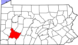
![]() Location within the U.S. state of Pennsylvania | |
![]() Pennsylvania's location within the U.S. | |
Coordinates: 40°19′N79°28′W / 40.31°N 79.47°W | |
Country | ![]() |
State | ![]() |
Founded | February 26, 1773 |
Named for | Westmorland |
Seat | Greensburg |
Largest city | Hempfield Township |
Area | |
• Total | 1,036 sq mi (2,680 km2) |
• Land | 1,028 sq mi (2,660 km2) |
• Water | 8.5 sq mi (22 km2) 0.8%% |
Population (2020) | |
• Total | 354,663 |
• Density | 345/sq mi (133/km2) |
Time zone | UTC−5 (Eastern) |
• Summer (DST) | UTC−4 (EDT) |
Congressional districts | 13th, 14th |
Website | www |
Westmoreland County is a county in the Commonwealth of Pennsylvania, United States. As of the 2020 census, the population was 364,663. [1] The county seat is Greensburg. [2] Formed from, successively, Lancaster, Northumberland, and later Bedford counties, Westmoreland County was founded on February 26, 1773, and was the first county in the colony of Pennsylvania whose entire territorial boundary was located west of the Allegheny Mountains. Westmoreland County originally included the present-day counties of Fayette, Washington, Greene, and parts of Beaver, Allegheny, Indiana, and Armstrong counties. It is named after Westmorland, a historic county of England.
Westmoreland County is included in the Pittsburgh Metropolitan Statistical Area.
Formed from Lancaster, Northumberland, and later Bedford counties, Westmoreland County was founded on February 26, 1773, and was the first county in the Pennsylvania colony whose entire territorial boundary was located west of the Allegheny Mountains. Westmoreland County originally included the present-day counties of Fayette, Washington, Greene, and parts of Beaver, Allegheny, Indiana, and Armstrong counties. It is named after Westmorland, a historic county of England.
According to the U.S. Census Bureau, the county has a total area of 1,036 square miles (2,680 km2), of which 1,028 square miles (2,660 km2) is land and 8.5 square miles (22 km2) (0.8%) is water. [3] Westmoreland has a humid continental climate (Dfa/Dfb). Average monthly temperatures in Greensburg range from 28.7 °F in January to 71.8 °F in July, while in Murrysville they range from 29.4 °F in January to 73.1 °F in July, in Latrobe they range from 28.9 °F in January to 72.0 °F in July, and in Ligonier they range from 28.1 °F in January to 71.1 °F in July. [4]
Historical population | |||
---|---|---|---|
Census | Pop. | %± | |
1790 | 16,019 | — | |
1800 | 22,726 | 41.9% | |
1810 | 26,392 | 16.1% | |
1820 | 30,540 | 15.7% | |
1830 | 38,400 | 25.7% | |
1840 | 42,699 | 11.2% | |
1850 | 51,726 | 21.1% | |
1860 | 53,736 | 3.9% | |
1870 | 58,719 | 9.3% | |
1880 | 78,036 | 32.9% | |
1890 | 112,819 | 44.6% | |
1900 | 160,175 | 42.0% | |
1910 | 231,304 | 44.4% | |
1920 | 273,568 | 18.3% | |
1930 | 294,995 | 7.8% | |
1940 | 303,411 | 2.9% | |
1950 | 313,179 | 3.2% | |
1960 | 352,629 | 12.6% | |
1970 | 376,935 | 6.9% | |
1980 | 392,294 | 4.1% | |
1990 | 370,321 | −5.6% | |
2000 | 369,993 | −0.1% | |
2010 | 365,169 | −1.3% | |
2020 | 354,663 | −2.9% | |
U.S. Decennial Census [5] 1790-1960 [6] 1900-1990 [7] 1990-2000 [8] 2010-2019 [9] 2010-2020 [10] |
At the 2010 census, [11] there were 365,169 people, 153,650 households and 101,928 families residing in the county. The population density was 355.4 per square mile (137.2/km2). There were 168,199 housing units at an average density of 163.7 per square mile (63.2/km2). The racial makeup of the county was 95.3% White, 2.3% Black or African American, 0.1% Native American, 0.7% Asian, 0.03% Pacific Islander, 0.2% from other races, and 1.2% from two or more races. 0.9% of the population were Hispanic or Latino of any race.
There were 153,650 households, of which 24.5% had children under the age of 18 living with them, 52.2% were married couples living together, 10.0% had a female householder with no husband present, and 33.7% were non-families. 29.0% of all households were made up of individuals, and 13.3% had someone living alone who was 65 years of age or older. The average household size was 2.32, and the average family size was 2.86.
22.3% of the population were under 18, 5.1% from 18 to 24, 22.4% from 25 to 44, 31.3% from 45 to 64, and 18.9% who were 65 years of age or older. The median age was 45.1 years. For every 100 females, there were 94.8 males. For every 100 females age 18 and over, there were 92.3 males.
Race | Num. | Perc. |
---|---|---|
White (NH) | 323,114 | 91.1% |
Black or African American (NH) | 8,985 | 2.53% |
Native American (NH) | 295 | 0.1% |
Asian (NH) | 3,301 | 1% |
Pacific Islander (NH) | 36 | 0.01% |
Other/Mixed (NH) | 13,702 | 3.86% |
Hispanic or Latino | 5,230 | 1.47% |
As of November 7, 2022, there are 248,459 registered voters in Westmoreland County. [13]
The Democratic Party historically dominated county-level politics between the New Deal realignment and the turn of the century; however, Westmoreland has trended Republican at the national and statewide levels in the 21st century (in direct lockstep with most other Appalachian counties). In 2000, Republican George W. Bush became the first Republican to carry the county since 1972, and Republicans have carried the county in every election since, increasing the margin of victory in every successive election until 2020. Democratic Governor Ed Rendell lost Westmoreland in both 2002 and 2006. In 2008, Republican Tim Krieger picked up the 57th House district left open by the retirement of Democratic state representative Tom Tangretti. In 2010, both Pat Toomey and Tom Corbett won Westmoreland in their statewide bids. Also, the GOP gained control of two more State House districts, the 54th with Eli Evankovich and the 56th with George Dunbar. In 2011, the Republican Party swept all county row offices. [14] A Democratic resurgence in 2015 gave that party a majority of the county commissioners. However, in the 2019 elections, Democratic elected officials lost that majority and carried only one row office.
As of 2020, the only majority-Dem cities within the county are Arnold and Monessen. [15]
Year | Republican | Democratic | Third party | |||
---|---|---|---|---|---|---|
No. | % | No. | % | No. | % | |
2020 | 130,299 | 63.46% | 72,192 | 35.16% | 2,839 | 1.38% |
2016 | 116,522 | 63.50% | 59,669 | 32.52% | 7,301 | 3.98% |
2012 | 103,932 | 61.29% | 63,722 | 37.58% | 1,918 | 1.13% |
2008 | 102,294 | 57.62% | 72,721 | 40.96% | 2,532 | 1.43% |
2004 | 100,087 | 56.01% | 77,774 | 43.52% | 835 | 0.47% |
2000 | 80,858 | 51.60% | 71,792 | 45.81% | 4,059 | 2.59% |
1996 | 62,058 | 43.30% | 63,686 | 44.43% | 17,585 | 12.27% |
1992 | 47,315 | 30.63% | 69,817 | 45.20% | 37,319 | 24.16% |
1988 | 61,472 | 44.13% | 76,710 | 55.07% | 1,108 | 0.80% |
1984 | 71,377 | 46.82% | 79,906 | 52.41% | 1,181 | 0.77% |
1980 | 63,140 | 45.06% | 68,627 | 48.97% | 8,372 | 5.97% |
1976 | 59,172 | 43.47% | 74,217 | 54.52% | 2,745 | 2.02% |
1972 | 75,085 | 54.60% | 59,322 | 43.13% | 3,120 | 2.27% |
1968 | 52,206 | 35.08% | 81,833 | 54.98% | 14,800 | 9.94% |
1964 | 41,493 | 27.77% | 107,131 | 71.70% | 792 | 0.53% |
1960 | 68,825 | 44.45% | 85,641 | 55.31% | 374 | 0.24% |
1956 | 66,580 | 47.77% | 72,616 | 52.10% | 192 | 0.14% |
1952 | 58,923 | 42.24% | 80,068 | 57.40% | 503 | 0.36% |
1948 | 41,709 | 39.05% | 61,901 | 57.95% | 3,204 | 3.00% |
1944 | 43,202 | 41.16% | 61,057 | 58.17% | 705 | 0.67% |
1940 | 42,643 | 39.56% | 64,567 | 59.90% | 577 | 0.54% |
1936 | 36,079 | 32.23% | 73,574 | 65.73% | 2,282 | 2.04% |
1932 | 30,426 | 37.73% | 45,436 | 56.34% | 4,789 | 5.94% |
1928 | 51,760 | 61.88% | 30,587 | 36.57% | 1,296 | 1.55% |
1924 | 34,522 | 55.22% | 10,223 | 16.35% | 17,769 | 28.42% |
1920 | 27,077 | 59.71% | 12,845 | 28.32% | 5,427 | 11.97% |
1916 | 15,283 | 46.68% | 13,829 | 42.24% | 3,625 | 11.07% |
1912 | 4,299 | 14.66% | 9,262 | 31.58% | 15,764 | 53.76% |
1908 | 15,429 | 52.00% | 11,101 | 37.41% | 3,141 | 10.59% |
1904 | 17,239 | 63.16% | 8,007 | 29.33% | 2,050 | 7.51% |
1900 | 16,014 | 57.00% | 11,010 | 39.19% | 1,072 | 3.82% |
1896 | 14,928 | 56.23% | 11,029 | 41.55% | 589 | 2.22% |
1892 | 10,804 | 48.84% | 10,747 | 48.58% | 569 | 2.57% |
1888 | 9,926 | 49.37% | 9,602 | 47.76% | 577 | 2.87% |
1884 | 8,339 | 47.52% | 8,346 | 47.56% | 864 | 4.92% |
1880 | 7,113 | 44.47% | 7,975 | 49.86% | 908 | 5.68% |
District | Representative | Party |
---|---|---|
33 | Carrie Delrosso | Republican |
52 | Ryan Warner | Republican |
54 | Bob Brooks | Republican |
55 | Jason Silvis | Republican |
56 | George Dunbar | Republican |
57 | Eric Nelson | Republican |
58 | Eric Davanzo | Republican |
59 | Leslie Rossi | Republican |
District | Senator | Party |
---|---|---|
32 | Patrick J. Stefano | Republican |
39 | Kim Ward | Republican |
41 | Joe Pittman | Republican |
45 | Jim Brewster | Democratic |
District | Representative | Party |
---|---|---|
13 | John Joyce | Republican |
14 | Guy Reschenthaler | Republican |
Senator | Party |
---|---|
John Fetterman | Democratic |
Bob Casey | Democratic |
School districts: [18]
According to EdNA [19]
Coal mining became a major industry in the county after the Civil War, followed by expansion of manufacturing of iron, steel and glass. The 600-acre coke works for the Isabella Furnace were built in Cokeville (then Coketown) in Spring of 1872. [20] [21] At one point, company "coal patches" (towns built for miners) represented about one-third of the county's settlements. [22] A major strike by coal miners represented by the United Mine Workers of America took place in 1910–1911. Sixteen people were killed in the strike. [23]
In 2020 the top industries in the county were health care and social services (16.3% of jobs), manufacturing (13.8%) and retail trade (13.7%). [24] Mining comprised less than 1% of the jobs in the county. Westmoreland County is now believed to be the site of over 100 abandoned mines. [25] [26]
Volkswagen's Westmoreland plant near New Stanton in Westmoreland County was the first foreign-owned factory mass-producing automobiles in the U.S. It operated from 1978 to 1988.
There are four Pennsylvania state parks in Westmoreland County.
Under Pennsylvania law, there are four types of incorporated municipalities: cities, boroughs, townships, and, in at most two cases, towns. The following cities, boroughs and townships are located in Westmoreland County:
Census-designated places are geographical areas designated by the U.S. Census Bureau for the purposes of compiling demographic data. They are not actual jurisdictions under Pennsylvania law. Other unincorporated communities, such as villages, may be listed here as well.
The population ranking of the following table is based on the 2010 census of Westmoreland County. [30]
†county seat
Rank | City/Town/etc. | Municipal type | Population (2010 Census) |
---|---|---|---|
1 | Murrysville | Municipality | 20,079 |
2 | † Greensburg | City | 14,892 |
3 | New Kensington | City | 13,116 |
4 | Lower Burrell | City | 11,761 |
5 | Jeannette | City | 9,654 |
6 | Latrobe | City | 8,338 |
7 | Monessen | City | 7,720 |
8 | Vandergrift | Borough | 5,205 |
9 | Arnold | City | 5,157 |
10 | Mount Pleasant | Borough | 4,454 |
11 | Scottdale | Borough | 4,384 |
12 | Level Green | CDP | 4,020 |
13 | Irwin | Borough | 3,973 |
14 | Loyalhanna | CDP | 3,428 |
15 | Manor | Borough | 3,239 |
16 | Trafford (partially in Allegheny County ) | Borough | 3,174 |
17 | Youngwood | Borough | 3,050 |
18 | Derry | Borough | 2,688 |
19 | Delmont | Borough | 2,686 |
20 | West Newton | Borough | 2,633 |
21 | Lawson Heights | CDP | 2,194 |
22 | New Stanton | Borough | 2,173 |
23 | Southwest Greensburg | Borough | 2,155 |
24 | South Greensburg | Borough | 2,117 |
25 | Lynnwood-Pricedale | CDP | 2,031 |
26 | North Belle Vernon | Borough | 1,971 |
27 | Ligonier | Borough | 1,573 |
28 | St. Vincent College | CDP | 1,357 |
29 | West Leechburg | Borough | 1,294 |
30 | Calumet | CDP | 1,241 |
31 | Fellsburg | CDP | 1,180 |
32 | Collinsburg | CDP | 1,125 |
33 | Avonmore | Borough | 1,011 |
34 | Norvelt | CDP | 948 |
35 | Export | Borough | 917 |
36 | North Irwin | Borough | 846 |
37 | Oklahoma | Borough | 809 |
38 | Herminie | CDP | 789 |
39 | Hostetter | CDP | 740 |
40 | New Florence | Borough | 689 |
41 | Yukon | CDP | 677 |
42 | East Vandergrift | Borough | 674 |
43 | Sutersville | Borough | 605 |
44 | Millwood | CDP | 566 |
45 | New Alexandria | Borough | 560 |
46 | Bradenville | CDP | 545 |
47 | Grapeville | CDP | 538 |
48 | Mammoth | CDP | 525 |
49 | Hyde Park | Borough | 500 |
50 | Seward | Borough | 495 |
51 | Wyano | CDP | 484 |
52 | Penn | Borough | 475 |
53 | Bolivar | Borough | 465 |
54 | Smithton | Borough | 399 |
55 | Madison | Borough | 397 |
56 | Slickville | CDP | 388 |
57 | Arona | Borough | 370 |
58 | Youngstown | Borough | 326 |
59 | Hunker | Borough | 291 |
60 | Crabtree | CDP | 277 |
61 | Webster | CDP | 255 |
62 | Adamsburg | Borough | 172 |
63 | Laurel Mountain | Borough | 167 |
64 | Harrison City | CDP | 134 |
65 | Donegal | Borough | 120 |
Latrobe is a city in Westmoreland County, Pennsylvania, in the United States and part of the Pittsburgh metropolitan area.
Allegheny County is a county in the Commonwealth of Pennsylvania. It is located in Southwestern Pennsylvania. As of the 2020 census, the population was 1,250,578, making it the state's second-most populous county, after Philadelphia County. Its county seat is Pittsburgh. Allegheny County is part of the Pittsburgh, PA metropolitan statistical area and the Pittsburgh media market.
Washington County is a county in the Commonwealth of Pennsylvania. As of the 2020 census, the population was 209,349. Its county seat is Washington.
Fayette County is a county in the Commonwealth of Pennsylvania. It is located in southwestern Pennsylvania, adjacent to Maryland and West Virginia. As of the 2020 census, the population was 128,804. Its county seat is Uniontown. The county was created on September 26, 1783, from part of Westmoreland County and named after the Marquis de Lafayette.
Plum is a borough in Allegheny County, Pennsylvania, United States. The population was 27,144 at the 2020 census. A suburb of the Pittsburgh metropolitan area, it is located northeast of the city in what is commonly referred to as the East Hills suburbs.
Bullskin Township is a township in Fayette County, Pennsylvania, United States. The population was 6,729 at the 2020 census, down from 6,966 at the 2010 census. It is served by the Connellsville Area School District.
Derry Township is a township in Westmoreland County, Pennsylvania. It surrounds the Borough of Derry, which is a separate municipality. As of the 2020 census, the township population was 13,631.
Greensburg is a city in and the county seat of Westmoreland County, Pennsylvania, United States, and a part of the Pittsburgh Metro Area. The city lies within the Laurel Highlands and the ecoregion of the Western Allegheny Plateau. The city is named after Nathanael Greene, a major general of the Continental Army in the American Revolutionary War. The population was 14,976 at the 2020 census.
Ligonier is a borough in Westmoreland County, Pennsylvania, United States. The population was 1,513 at the 2020 census. Ligonier was settled in the 1760s. The borough is well known for nearby Idlewild Park, one of the oldest amusement parks in the country; and nearby Seven Springs Mountain Resort. Another tourist attraction is Fort Ligonier Days, a parade and craft market that takes place every fall over the course of three days, and the Ligonier Country Market in the summer months. Ligonier is part of the Pittsburgh Metropolitan Statistical Area.
Murrysville, known formally by its legal name in its Charter as The Municipality of Murrysville, is designated as a home rule status community in Westmoreland County, Pennsylvania, United States. The population was 20,079 at the 2010 census. It became a home rule Municipality in August 1976, when its electorate voted for its Charter designating it a Municipality.
Penn Township is a township in Westmoreland County, Pennsylvania, United States.
Westmoreland County Community College is a public community college in Youngwood, Pennsylvania. It was founded in 1970 during an era of community college proliferation within the state. Its location on the suburban fringe was designed to attract students from both the Westmoreland County suburbs of Pittsburgh and the Monongahela Valley, then a still booming industrial center. The college has also extended its outreach to provide services to students from Fayette and Indiana Counties.
Greater Pittsburgh is a populous region centered around its largest city and economic hub, Pittsburgh, Pennsylvania. The region encompasses Pittsburgh's urban core county, Allegheny, and six adjacent Pennsylvania counties: Armstrong, Beaver, Butler, Fayette, Washington, and Westmoreland in Western Pennsylvania, which constitutes the Pittsburgh, PA Metropolitan Statistical Area MSA as defined by the U.S. Census Bureau.
A heat advisory is a notice issued by the National Weather Service of the United States. Local offices often have their own criteria. High values of the heat index are caused by temperatures being significantly above normal and high humidities, and such high levels can pose a threat to human life through conditions such as heat stroke.
Pennsylvania State Senate District 39 includes part of Westmoreland County. It is currently represented by Republican Kim Ward.
Pennsylvania's 12th congressional district is located in the southwestern Pennsylvania, which includes Pittsburgh and much of Allegheny County. It has been represented since January 3, 2023 by Summer Lee.
Pennsylvania Route 366 is a 14.8-mile-long (23.8 km) state highway located in Allegheny and Westmoreland Counties in Pennsylvania. The western terminus is at PA 28 in Tarentum. The eastern terminus is at PA 66 in Murrysville. The last 1/2 mile of the Red Belt route of the Allegheny County belt system runs along PA 366 in Tarentum from its eastbound beginning at the PA 28 interchange to the intersection of Freeport Rd. and Ross St. where the Red Belt terminates.
Pennsylvania State Senate District 41 includes all of Armstrong County and Indiana County and parts of Jefferson County and Westmoreland County. It is currently represented by Republican Joe Pittman.
The 59th Pennsylvania House of Representatives District is located in southwest Pennsylvania and has been represented by Leslie Rossi since 2021.
The Westmoreland County Transit Authority (WCTA) is the operator of mass transportation in Westmoreland County, Pennsylvania. Using 35 buses, a total of 18 routes are operated, the majority of which serve the urbanized corridor that makes up the western portion of the county. Bus routes in this area are designed to provide access for suburban commuters to Downtown Pittsburgh, as well as transportation for both workers and shoppers to the large suburbs of Greensburg and New Kensington, Pennsylvania the most prominent entities in the county's boundaries. Rural eastern bus routes allow for commutes to Greensburg and also provide service to the city of Johnstown in neighboring Cambria County.
{{cite web}}
: CS1 maint: multiple names: authors list (link)