Unity Township, Pennsylvania

Last updated

Unity Township, Pennsylvania
Sign, building.jpg
Township office, Beatty County Road and Beatty Village Road
Map of Westmoreland County, Pennsylvania Highlighting Unity Township.PNG
Map of Westmoreland County, Pennsylvania Highlighting Unity Township
Map of Pennsylvania highlighting Westmoreland County.svg
Map of Pennsylvania highlighting
Westmoreland County
Country United States
State Pennsylvania
County Westmoreland
Settled1760
IncorporatedSeptember 23, 1789
Area
[1]
  Total67.58 sq mi (175.02 km2)
  Land67.44 sq mi (174.67 km2)
  Water0.14 sq mi (0.35 km2)
Population
  Total21,724
  Estimate 
(2021) [2]
21,599
Time zone UTC-5 (Eastern (EST))
  Summer (DST) UTC-4 (EDT)
Area code 724
FIPS code 42-129-78656
Website http://www.unitytownship.org

Unity Township is a township in Westmoreland County, Pennsylvania, United States. The population was 21,724 at the 2020 census, [2] a decline of approximately 4% compared to the 2010 census.

Contents

The township is home to Saint Vincent Archabbey, College and Seminary, as well as Arnold Palmer Regional Airport. The Norfolk Southern Railway (once part of the Pennsylvania Railroad mainline) runs through the northern section of the township. [3]

History

Unity Township was incorporated on September 23, 1789. Initial records show settlement going back to 1760. Residents of Mount Pleasant Township petitioned the court to establish a new township around the area next to the Loyalhanna creek, based on the inconveniently large size of the existing township, which made it necessary to travel long distances to conduct township affairs. One of the oldest communities in the township was Youngstown, an important stop in the wagon and stagecoach era, ca. 1818–1852, which became a separate borough in 1831. [4]

The township is home to Unity Cemetery, which was established in 1774. [5] Some 15,000 people are believed to buried in the cemetery, [6] including Colonel John Proctor, [7] 31 other Revolutionary War veterans, U.S. Congressman William Findley [8] and television host Fred Rogers.

In 1847 the Sisters of Mercy, an Irish Catholic order, established St. Xavier's Academy for Girls in Unity. [9] In time, it expanded to include a convent. The buildings were destroyed by a fire in 1972, but the sisters' cemetery on the former school grounds in Unity remains. [10] [11] [12]

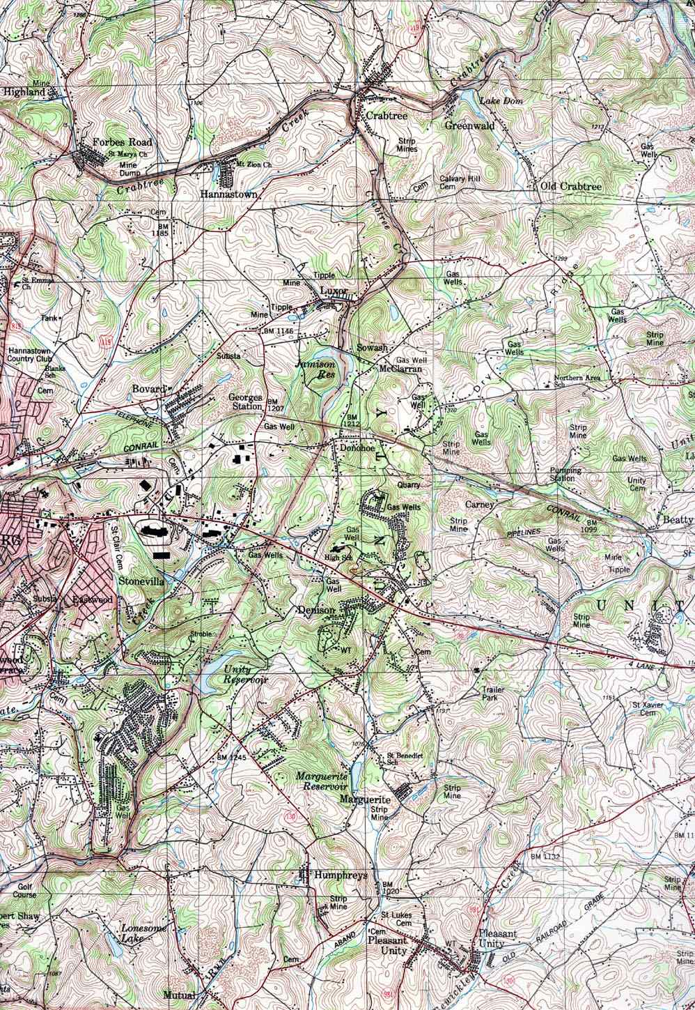
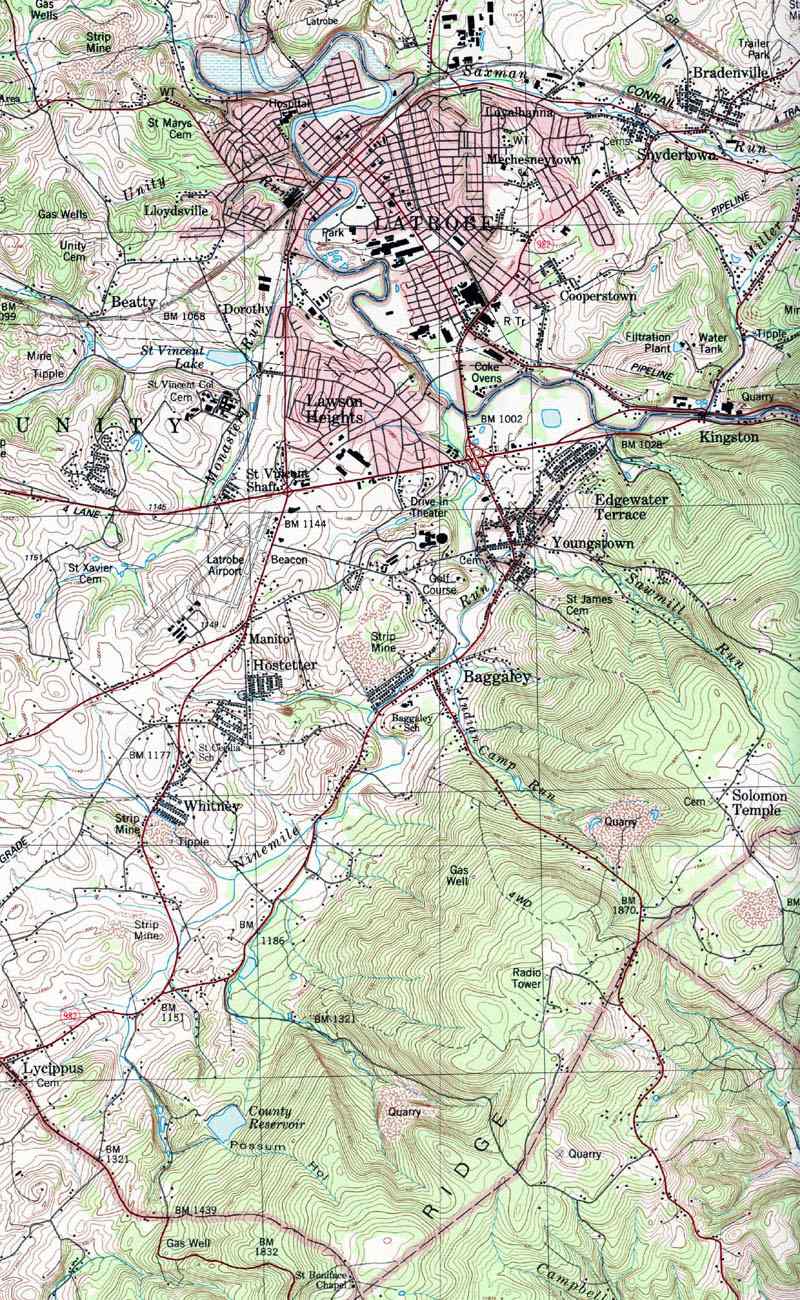
For a time the coal industry "dwarfed all others" in the township, according to historian John Boucher, writing in 1906. [13] Mines which once operated in Unity Township included those named Carney, Humphries, Dorothy, Marguerite, Mutual, Puritan (in Baggaley), Whitney, Jamison No. 20 (in Pleasant Unity), Hostetter, Beatty and St. Vincent's Shaft. Many of them were constructed in the period 1880 to 1900. All have long since closed. Extensive land remediation has taken place and few traces of the mines remain, but their names survive in township neighborhoods and streets. [14] [15] [16] [17] [18] [19]

Carr's Tunnel, an abandoned railroad tunnel, is located in Unity Township. Locally known as Witches' Tunnel, it is on a now-dismantled spur of the Pennsylvania Railroad which serviced coal mines in the area, including the Carney mine. [20]

The Kingston House and St. Vincent Archabbey Gristmill are listed on the National Register of Historic Places. [21]

Geography

According to the United States Census Bureau, the township has a total area of 67.3 square miles (174.2 km2), of which 67.1 square miles (173.8 km2) is land and 0.2 square mile (0.4 km2) (0.24%) is water.

The township contains the following communities: Baggaley, Beatty, Carney, Denison, Donohoe, Dorothy, Dry Ridge, George's Station, Greenwald, Hostetter, Humphreys, Lawson Heights, Lloydsville, Lycippus, Manito, Marguerite, Mutual, Old Crabtree, Pleasant Unity, and Whitney. To the west lies Hempfield Township; to the east, Latrobe Borough and Derry Township.

Demographics

Historical population
CensusPop.Note
1940 10,994
1950 12,39212.7%
1960 15,51925.2%
1970 18,41918.7%
1980 19,9768.5%
1990 20,1090.7%
2000 21,1375.1%
2010 22,6077.0%
2020 21,724−3.9%
2021 (est.)21,599 [2] −0.6%
U.S. Decennial Census [22] [23] [24]

At the 2000 census there were 21,137 people, 7,963 households, and 5,773 families living in the township. The population density was 315.0 inhabitants per square mile (121.6/km2). There were 8,372 housing units at an average density of 124.8 per square mile (48.2/km2). The racial makeup of the township was 98.12% White, 0.32% African American, 0.13% Native American, 0.86% Asian, 0.02% Pacific Islander, 0.15% from other races, and 0.40% from two or more races. Hispanic or Latino people of any race were 0.42%. [25]

Of the 7,963 households 29.5% had children under the age of 18 living with them, 61.9% were married couples living together, 7.5% had a female householder with no husband present, and 27.5% were non-families. 24.6% of households were one person and 11.4% were one person aged 65 or older. The average household size was 2.48 and the average family size was 2.95.

The age distribution was 21.5% under the age of 18, 9.1% from 18 to 24, 26.4% from 25 to 44, 25.8% from 45 to 64, and 17.2% 65 or older. The median age was 41 years. For every 100 females, there were 96.7 males. For every 100 females age 18 and over, there were 93.6 males.

The median household income was $40,585 and the median family income was $49,593. Males had a median income of $37,907 versus $26,164 for females. The per capita income for the township was $21,116. About 5.8% of families and 8.7% of the population were below the poverty line, including 10.0% of those under age 18 and 9.8% of those age 65 or over.

Notable people

Related Research Articles

<span class="mw-page-title-main">Latrobe, Pennsylvania</span> City in Pennsylvania, United States

Latrobe is a city in Westmoreland County, Pennsylvania, United States. The population was 8,060 as of the 2020 census. A part of the Pittsburgh metropolitan area, it is located near Pennsylvania's scenic Chestnut Ridge. Latrobe was incorporated as a borough in 1854, and as a city in 1999. The current mayor is Eric J. Bartels.

<span class="mw-page-title-main">Westmoreland County, Pennsylvania</span> County in Pennsylvania, United States

Westmoreland County is a county in the Commonwealth of Pennsylvania, United States, located in the Pittsburgh Metropolitan Statistical Area. As of the 2020 census, the population was 354,663. The county seat is Greensburg and the most populous community is Hempfield Township. It is named after Westmorland, a historic county of England.

<span class="mw-page-title-main">Kiskiminetas Township, Armstrong County, Pennsylvania</span> Township in Pennsylvania, United States

Kiskiminetas Township is a township in Armstrong County, Pennsylvania, United States. The population was 4,604 at the 2020 census, a decrease from the figure of 4,800 tabulated in 2010, making it the most populous township or borough in the county.

<span class="mw-page-title-main">Perry Township, Fayette County, Pennsylvania</span> Township in Pennsylvania, United States

Perry Township is a township in Fayette County, Pennsylvania, United States. The population was 2,339 at the 2020 census, a decline from the figure of 2,552 tabulated in 2010. The Frazier School District serves the township.

<span class="mw-page-title-main">Summit Township, Somerset County, Pennsylvania</span> Township in Pennsylvania, United States

Summit Township is a township in Somerset County, Pennsylvania, United States. The population was 2,141 at the 2020 census. It is part of the Johnstown, Pennsylvania, Metropolitan Statistical Area.

<span class="mw-page-title-main">Sugar Grove Township, Warren County, Pennsylvania</span> Township in Pennsylvania, United States

Sugar Grove Township is a township in Warren County, Pennsylvania, United States. The population was 1,613 at the 2020 census,Bureau, US Census. "City and Town Population Totals: 2020-2021". Census.gov. US Census Bureau. Retrieved June 25, 2022.</ref> down from 1,723 at the 2010 census.

<span class="mw-page-title-main">Smith Township, Washington County, Pennsylvania</span> Township in Pennsylvania, United States

Smith Township is a township in Washington County, Pennsylvania, United States. As of the 2020 census, the township population was 4,224.

<span class="mw-page-title-main">Bell Township, Westmoreland County, Pennsylvania</span> Township in Pennsylvania, United States

Bell Township is a township in Westmoreland County, Pennsylvania, United States. The population was 2,080 at the 2020 decennial census.

<span class="mw-page-title-main">Cook Township, Westmoreland County, Pennsylvania</span> Township in Pennsylvania, United States

Cook Township is a township in Westmoreland County, Pennsylvania, United States. The population was 1,888 at the 2020 census, a decrease from 2,250 at the 2010 census, and 2,403 at the 2000 census.

<span class="mw-page-title-main">Crabtree, Pennsylvania</span> CDP in Pennsylvania, United States

Crabtree is a census-designated place (CDP) and former coal town in Salem Township, Westmoreland County, Pennsylvania, United States. The population was 277 at the 2010 census. It has its own post office, with postal code 15624.

<span class="mw-page-title-main">Derry Township, Westmoreland County, Pennsylvania</span> Township in Pennsylvania, United States

Derry Township is a township in Westmoreland County, Pennsylvania, United States. It surrounds the borough of Derry, which is a separate municipality. As of the 2020 census, the township population was 13,631.

<span class="mw-page-title-main">Donegal Township, Westmoreland County, Pennsylvania</span> Township in Pennsylvania, United States

Donegal Township is a township in Westmoreland County, Pennsylvania, United States. The population was 2,192 at the 2020 census, a decrease of 9% compared to 2010.

<span class="mw-page-title-main">East Huntingdon Township, Westmoreland County, Pennsylvania</span> Township in Pennsylvania, United States

East Huntingdon Township is a township in Westmoreland County, Pennsylvania, United States. The population was 7,712 at the 2020 census. From 1978 to 1988, the township had been home to the Volkswagen Westmoreland Assembly Plant, which later became a Sony plant. As of 2020 companies there include DNP, Cenveo, and Siemens.

<span class="mw-page-title-main">Export, Pennsylvania</span> Borough in Pennsylvania, United States

Export is a borough in Westmoreland County, Pennsylvania, United States, surrounded entirely by the Municipality of Murrysville. The population was 893 at the 2020 census.

<span class="mw-page-title-main">Herminie, Pennsylvania</span>

Herminie is a census-designated place (CDP) in Sewickley Township, Westmoreland County, Pennsylvania, United States. The population was 856 at the 2000 census.

<span class="mw-page-title-main">Irwin, Pennsylvania</span> Borough in Pennsylvania, United States

Irwin is a borough in Westmoreland County, Pennsylvania, 22 miles (35 km) southeast of Pittsburgh. Some of the most extensive bituminous coal deposits in the commonwealth are located here. In the past, iron foundries, flour mills, car shops, facing and planing mills, electricals goods, and mirror factories provided employment to the residents. In 1900, the population numbered 2,452; it increased to 2,886 in 1910. The population was 3,973 at the 2010 census.

<span class="mw-page-title-main">Slickville, Pennsylvania</span> CDP in Pennsylvania, United States

Slickville is a census-designated place (CDP) in Westmoreland County, Pennsylvania, United States. The population was 372 at the 2000 census.

<span class="mw-page-title-main">Washington Township, Westmoreland County, Pennsylvania</span> Township in Pennsylvania, United States

Washington Township is a township in Westmoreland County, Pennsylvania, United States. It was founded in 1789 from Salem Township. At that time, it included the present-day municipalities of Allegheny, Lower Burrell, Upper Burrell, and most of Bell. In 2020, the population of Washington Twp was 6,887.

<span class="mw-page-title-main">Brenizer, Pennsylvania</span> Unincorporated community in Pennsylvania, United States

Brenizer, also known as Breinizer, is an unincorporated community and coal town in Derry Township, Westmoreland County, Pennsylvania, United States.

<span class="mw-page-title-main">Bradenville, Pennsylvania</span> Census-designated place in Pennsylvania, United States

Bradenville is a census-designated place and coal town in Derry Township in Westmoreland County, Pennsylvania, United States. The community is located within two miles of the city of Latrobe and is three miles from the borough of Derry.

References

  1. "2016 U.S. Gazetteer Files". United States Census Bureau. Retrieved August 14, 2017.
  2. 1 2 3 4 Bureau, US Census. "City and Town Population Totals: 2020—2021". Census.gov. US Census Bureau. Retrieved July 26, 2022.
  3. "Unity: Second Class Township Map" (PDF). PennDot.gov. Pennsylvania Department of Transportation. Retrieved February 12, 2022.
  4. History of Westmoreland County Volume 1, Chapter 41
  5. Bell, Joseph. "Unity Cemetery, Chapel mark monumental anniversaries". Latrobe Bulletin News.
  6. Himler, Jeff (March 3, 2024). "Yearlong Celebrations: Latrobe Presbyterians mark 250th anniversary of Unity Cemetery". Tribune Review, Pittsburgh PA.
  7. Burke, Mike (June 14, 2018). "Don't Tread on Me: The Flag of Colonel John Proctor's 1st Battalion of Westmoreland County, Pa". Heinz History Center. Retrieved February 13, 2022.
  8. Wertz, Marjorie. "Unity Cemetery a lesson in military history". TribLive. Tribune-Review. Retrieved February 13, 2022.
  9. Zufelt, Jerry. "History of the Diocese". The Catholic Accent. Retrieved February 13, 2022.
  10. Scott, Rebekah. "Sisters of Mercy continue to serve Pittsburghers in need". Pittsburgh Post-Gazette. Retrieved February 13, 2022.
  11. "St. Xavier Academy relocated". Catholic News Archive. Retrieved February 13, 2022.
  12. "St. Xavier's historical marker". Explore PA History.
  13. Boucher, John Newton (1906). The History of Westmoreland County. p. 554. Retrieved February 13, 2022.
  14. Muller, Edward and Carlisle, Ronald (1994). Westmoreland County, Pennsylvania: An Inventory of Historic Engineering and Industrial Sites (PDF). National Park Service, U.S. Department of the Interior. pp. 53–124.{{cite book}}: CS1 maint: multiple names: authors list (link)
  15. "Monastery Run Improvement Project History". Winnie Palmer Nature Preserve. Retrieved March 1, 2022.
  16. Federoff, Stacey. "Treatment ponds for mine drainage planned for Unity". TribLive. Tribune-Review. Retrieved February 17, 2022.
  17. Himler, Jeff. "Ligonier coal company honored for mining reclamation". TribLive. Tribune-Review. Retrieved February 14, 2022.
  18. "WPCAMR means hope for Western Pennsylvania's Streams". Western Pennsylvania Coalition for Abandoned Mine Reclamation. Retrieved February 13, 2022.
  19. Washlaski, Raymond A. "Saint Vincent's Shaft Mine". Virtual Museum of Coal Mining in Pennsylvania. academia.edu. Retrieved March 3, 2024.
  20. "Carr's Tunnel and Carney Mine". Old Industry of Southwestern Pennsylvania. Retrieved March 3, 2024.
  21. "National Register Information System". National Register of Historic Places . National Park Service. July 9, 2010.
  22. "Census of Population and Housing". Census.gov. Retrieved June 4, 2016.
  23. https://www.census.gov/prod/cen1990/cph2/cph-2-40.pdf [ bare URL PDF ]
  24. https://www2.census.gov/prod2/decennial/documents/17216604v1p40ch02.pdf [ bare URL PDF ]
  25. "U.S. Census website". United States Census Bureau . Retrieved January 31, 2008.
  1. Unity West
  2. Unity East

40°14′00″N79°21′59″W / 40.23333°N 79.36639°W / 40.23333; -79.36639