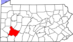
Millwood, Pennsylvania

Last updated

Millwood
USA Pennsylvania location map.svg
Red pog.svg
Millwood
Location within the state of Pennsylvania
Coordinates: 40°21′9″N79°16′42″W / 40.35250°N 79.27833°W / 40.35250; -79.27833
Country United States
State Pennsylvania
County Westmoreland
Area
[1]
  Total0.62 sq mi (1.61 km2)
  Land0.62 sq mi (1.61 km2)
  Water0.00 sq mi (0.00 km2)
Elevation
1,188 ft (362 m)
Population
 (2020) [2]
  Total483
  Density779.03/sq mi (300.88/km2)
Time zone UTC-5 (Eastern (EST))
  Summer (DST) UTC-4 (EDT)
ZIP code
15627 [3]
Area code 724
FIPS code 42-49960
GNIS feature ID1181291 [4]

Millwood is a census-designated place [5] and coal town located in Westmoreland County, Pennsylvania, United States. Their post office closed in 1927. [6] It was also known as Akers. As of the 2010 census [7] the population was 566 residents.

Demographics

Historical population
CensusPop.Note
2020 483
U.S. Decennial Census [8]

Related Research Articles

<span class="mw-page-title-main">New Bloomfield, Pennsylvania</span> Borough in Pennsylvania, United States

Bloomfield, commonly known as New Bloomfield, is a borough in, and the county seat of, Perry County, Pennsylvania, United States. It is part of the Harrisburg–Carlisle metropolitan statistical area. The population was 1,244 at the 2020 census.

Hickory is a census-designated place located in Mount Pleasant Township, Washington County in the state of Pennsylvania. As of the 2010 census the population was 740 residents.

Baumstown is a census-designated place in Exeter Township, Berks County, Pennsylvania, United States, located near the borough of Birdsboro. It is located at the junction of U.S. Highway 422 and Pennsylvania Route 345. As of the 2010 census the population of Baumstown was 422 residents.

Blandon is a census-designated place in Maidencreek Township, Berks County, Pennsylvania, United States. It is located at the junction of Pennsylvania Route 73 and Park Road. As of the 2010 census, the population was 7,152 residents.

<span class="mw-page-title-main">Gibraltar, Pennsylvania</span> Census-designated place in Pennsylvania, United States

Gibraltar is a census-designated place (CDP) in northern Robeson Township in southern Berks County, Pennsylvania, United States. Its population was 680 as of the 2010 census. The community is four miles from Birdsboro and 6.4 miles from downtown Reading. It is served by the Twin Valley School District and is across the Schuylkill River from Exeter.

<span class="mw-page-title-main">Alleghenyville, Pennsylvania</span> Census-designated place in Pennsylvania, United States

Alleghenyville is a census-designated place (CDP) in Brecknock Township, Berks County, Pennsylvania, United States. It is located near the Lancaster County line, and is served by the Governor Mifflin School District. As of the 2010 census the population was 1,134.

Eagle Lake is a census-designated place (CDP) in Covington Township, Lackawanna County, Pennsylvania, United States. As of the 2010 census, the population was 12. At that time, of 95 total housing units, five were occupied, while the remainder were for seasonal or recreational use.

Mohrsville is a census-designated place in Centre Township, Berks County, Pennsylvania, United States. It is located approximately three miles south of the borough of Shoemakersville, along the Schuylkill River. As of the 2010 census, the population was 383 residents.

<span class="mw-page-title-main">Mocanaqua, Pennsylvania</span> Census-designated place in Pennsylvania, United States

Mocanaqua is an unincorporated community and census-designated place (CDP) in Conyngham Township, Luzerne County, Pennsylvania, United States. The population was 646 at the 2010 census.

<span class="mw-page-title-main">Foot of Ten, Pennsylvania</span> Census-designated place in Pennsylvania, United States

Foot of Ten is a census-designated place in Allegheny and Juniata Townships in Blair County, Pennsylvania, United States. It is located approximately one mile west of the small borough Duncansville on Foot of Ten Road, and about 2.5 miles (4 km) north of the even smaller borough Newry. It is often considered a region of Duncansville, despite lying outside the borough limits. As of the 2010 census, the population was 672 residents.

Pleasant View is a census-designated place (CDP) in Armstrong County, Pennsylvania, United States. The population was 677 at the 2020 census. Pleasant View was formerly part of the census-designated place of North Vandergrift-Pleasant View at the 2000 Census, before splitting into two separate CDPs for the 2010 census.

Earlston is a census-designated place in West Providence Township, Bedford County, Pennsylvania, in the United States. The population was 1,049 as of the 2020 census. It is located just across the Raystown Branch of the Juniata River from the borough of Everett.

Colony Park is a census-designated place in Spring Township, Berks County, Pennsylvania, United States. It is located just off U.S. 222, approximately one mile northwest of the borough of Wyomissing. As of the 2010 census, the population was 1,076 residents.

Grazierville is a census-designated place in Snyder Township, Blair County, Pennsylvania, United States. It is located near I-99 and is approximately one mile to the south of the borough of Tyrone. As of the 2010 census, the population was 665 residents.

Blandburg is an unincorporated community and census-designated place (CDP) in Reade Township, Cambria County, Pennsylvania, United States, located along Pennsylvania Route 865 in far northeastern Cambria County. As of the 2010 census, the population was 402 residents.

<span class="mw-page-title-main">Marianne, Pennsylvania</span> Census designated place in Pennsylvania, United States

Marianne is a census-designated place located in Paint Township and Elk Township, Clarion County, in the U.S. state of Pennsylvania. The community is located at the intersections of Pennsylvania Route 66 and U.S. Route 322, approximately 1 mile (1.6 km) east of the borough of Shippenville and 3 miles (5 km) northwest of Clarion, the county seat. As of the 2010 census the population of Marianne was 1,167.

<span class="mw-page-title-main">Arnot, Pennsylvania</span> Census-designated place in Pennsylvania, United States

Arnot is a census-designated place located in Bloss Township, Tioga County in the state of Pennsylvania, United States. It is located off US Route 15 near the borough of Blossburg. As of the 2010 census, the population was 332 residents.

Fellsburg is a census-designated place located in Rostraver Township, Westmoreland County in the state of Pennsylvania, United States. It is home to the Fells Church, overlooking the Monongahela and Youhgiogheny Valleys. As of the 2010 census the population was 1,180 residents.

<span class="mw-page-title-main">Noxen, Pennsylvania</span> Census-designated place in Pennsylvania, United States

Noxen is a census-designated place that is located in Noxen Township, Wyoming County in the Commonwealth of Pennsylvania in the United States.

<span class="mw-page-title-main">Spokane metropolitan area</span> Metropolitan statistical area in Washington, United States

The Spokane–Spokane Valley Metropolitan Statistical Area, as defined by the United States Census Bureau, is an area consisting of Spokane and Stevens counties in Washington state, anchored by the city of Spokane and its largest suburb, Spokane Valley. As of July 1, 2021, the MSA had an estimated population of 593,466. The Spokane Metropolitan Area and the neighboring Coeur d'Alene metropolitan area, make up the larger Spokane–Coeur d'Alene combined statistical area. The urban areas of the two MSAs largely follow the path of Interstate 90 between Spokane and Coeur d'Alene. In 2010, the Spokane–Spokane Valley MSA had a gross metropolitan product of $20.413 billion.

References

  1. "ArcGIS REST Services Directory". United States Census Bureau. Retrieved October 12, 2022.
  2. "Census Population API". United States Census Bureau. Retrieved October 12, 2022.
  3. "Millwood PA ZIP Code". zipdatamaps.com. 2023. Retrieved October 31, 2023.
  4. U.S. Geological Survey Geographic Names Information System: Millwood, Pennsylvania
  5. "Millwood 2010 Census Information". Archived from the original on April 9, 2013.
  6. http://webpmt.usps.gov/pmt007.cfm . Retrieved July 30, 2012.{{cite web}}: Missing or empty |title= (help)[ dead link ]
  7. Bureau, US Census. "Census.gov". www.census.gov.
  8. "Census of Population and Housing". Census.gov. Retrieved June 4, 2016.