Penn Township, Westmoreland County, Pennsylvania

Last updated

Penn Township
Bushy Run monument.JPG
Monument at the Bushy Run Battlefield
Map of Westmoreland County, Pennsylvania Highlighting Penn Township.PNG
Map of Westmoreland County, Pennsylvania Highlighting Penn Township
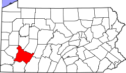
Map of Pennsylvania highlighting Westmoreland County.svg
Map of Pennsylvania highlighting
Westmoreland County
Country United States
State Pennsylvania
County Westmoreland
Area
[1]
  Total30.76 sq mi (79.68 km2)
  Land30.76 sq mi (79.68 km2)
  Water0.00 sq mi (0.00 km2)
Population
 (2010) [2]
  Total20,047 Increase2.svg
  Estimate 
(2021) [2]
20,346
  Density650.3/sq mi (245.74/km2)
Time zone UTC-5 (Eastern (EST))
  Summer (DST) UTC-4 (EDT)
FIPS code 42-129-58880
Website https://penntwp.org/

Penn Township is a township in Westmoreland County, Pennsylvania, United States.

Contents

History

Penn Township, officially known as the Township of Penn, was named after Pennsylvania founder William Penn. The township was incorporated on February 23, 1855.

In the early years after its founding, numerous Scotch-Irish Americans came to the area to farm its rich land. Later in the township's history, coal mining contributed heavily to the economy. [3]

Penn Township is also home to the Bushy Run Battlefield. The Bushy Run Battlefield was listed on the National Register of Historic Places in 1966, and is designated a National Historic Landmark. [4]

In 1957 Carnegie Mellon University chose the township for a new lab facility. [5]

Geography

Penn Township is located in the western part of Westmoreland County. It is approximately 25 miles east from Pittsburgh and seven miles west of Greensburg. The township is bordered by north by Murrysville, to the northeast by Salem Township, to the east by Hempfield Township, to the southeast by Jeannette, to the southwest by North Huntington Township, to the west-southwest by Trafford, and to the west by Monroeville. [6]

Penn Township maintains nearly 100 miles of roadways. The township has three major transportation routes within its boundaries: Pennsylvania Route 130, Pennsylvania Route 993, and the Pennsylvania Turnpike. [7]

According to the United States Census Bureau, the township has a total area of 30.76 square miles (79.7 km2), all 0 land.

Penn Township is also part of the Turtle Creek (Monongahela River tributary) watershed.

Government

Penn Township was incorporated in 1855 and became a First Class township in 1958. [3] The township is governed by five commissioners who are publicly elected and serve a four-year term. Penn Township also has a tax collector elected to serve a four-year term.

Like all First Class Townships, Penn Township has a fully functioning police force.

Demographics

Historical population
CensusPop.Note
1940 6,085
1950 7,46122.6%
1960 10,70243.4%
1970 12,97521.2%
1980 16,15324.5%
1990 15,945−1.3%
2000 19,59122.9%
2010 20,0052.1%
2020 20,0470.2%
2021 (est.)20,346 [2] 1.5%

Population

As of July 1, 2021, Penn Township has a population of 20,346. This is a 1.5% increase from the 2020 US Census Population.

Age and Sex

Penn Township [8] Pennsylvania United States
Persons under 5 Years, percent5.45.56.1
Persons under 18 Years, percent20.020.722.4
Persons 65 Years and over, percent18.718.216.0
Female Persons, percent50.45150.

Race

Penn Township [8] PennsylvaniaUnited States
White alone, percent98.081.876.5
Black or African American alone, percent0.212.013.4
American Indian and Alaska Native alone, percent0.00.41.3
Asian alone, percent0.13.75.9
Native Hawaiian and Other Pacific Islander alone, percent0.10.10.2
Two or More Races, percent1.52.12.7
Hispanic or Latino, percent0.77.618.3
White alone, not Hispanic or Latino, percent97.676.160.4

Education

Penn Township is within the Penn-Trafford School District. [9] The district operates eight schools, six of which are in Penn Township:

The Murrysville branch of the Westmoreland County Community College is located along Mellon Road.

Penn Township has an overall graduation rate of 96.3% and a bachelor's degree rate of 37.7% [8]

Related Research Articles

<span class="mw-page-title-main">Allegheny County, Pennsylvania</span> County in Pennsylvania, United States

Allegheny County is a county in Pennsylvania, United States. As of the 2020 census, the population was 1,250,578, making it the state's second-most populous county, after Philadelphia County. Its county seat and most populous city is Pittsburgh, Pennsylvania's second most populous city. The county is part of the Greater Pittsburgh region of the state, and is the center of the Pittsburgh media market.

<span class="mw-page-title-main">Westmoreland County, Pennsylvania</span> County in Pennsylvania, United States

Westmoreland County is a county in the Commonwealth of Pennsylvania, United States, located in the Pittsburgh Metropolitan Statistical Area. As of the 2020 census, the population was 354,663. The county seat is Greensburg and the most populous community is Hempfield Township. It is named after Westmorland, a historic county of England. The county is part of the Southwest Pennsylvania region of the state.

<span class="mw-page-title-main">Fayette County, Pennsylvania</span> County in Pennsylvania, United States

Fayette County is a county in the Commonwealth of Pennsylvania. It is located in southwestern Pennsylvania, adjacent to Maryland and West Virginia. As of the 2020 census, the population was 128,804. Its county seat is Uniontown. The county was created on September 26, 1783, from part of Westmoreland County and named after the Marquis de Lafayette. The county is part of the Southwest Pennsylvania region of the state.

<span class="mw-page-title-main">Monroeville, Pennsylvania</span> Borough in Pennsylvania, United States

Monroeville is a home rule municipality in Allegheny County, Pennsylvania, United States. It is a suburb with mixed residential and commercial developments located about 10 miles (16 km) east of Pittsburgh. As of the 2020 census, Monroeville was home to 28,640 people.

<span class="mw-page-title-main">Plum, Pennsylvania</span> Borough in Pennsylvania, United States

Plum is a borough in Allegheny County, Pennsylvania, United States. The population was 27,144 at the 2020 census. A suburb of the Pittsburgh metropolitan area, it is located northeast of the city in what is commonly referred to as the East Hills suburbs.

<span class="mw-page-title-main">Birmingham Township, Chester County, Pennsylvania</span> Township in Pennsylvania, United States

Birmingham Township is a township in Chester County, Pennsylvania, United States. The population was 4,085 at the 2020 census.

<span class="mw-page-title-main">East Brandywine Township, Pennsylvania</span> Township in Pennsylvania, United States

East Brandywine Township is a township in Chester County, Pennsylvania, United States. The population was 9,746 at the 2020 census.

<span class="mw-page-title-main">Easttown Township, Pennsylvania</span> Township in Pennsylvania, United States

Easttown Township is a township in Chester County, Pennsylvania, United States. The population was 10,984 at the 2020 census. The township, which lies in the western half of Philadelphia's Main Line suburbs, is comprised predominantly of parts of two unincorporated areas: Devon and Berwyn. A small portion of the township has a Paoli address.

<span class="mw-page-title-main">Schuylkill Township, Chester County, Pennsylvania</span> Township in Pennsylvania, United States

Schuylkill Township is a township in Chester County, Pennsylvania, United States. It contains the village of Valley Forge. The population was 8,516 at the 2010 census.

<span class="mw-page-title-main">North Union Township, Fayette County, Pennsylvania</span> Township in Pennsylvania, United States

North Union Township is a township in Fayette County, Pennsylvania, United States. The population was 11,829 at the 2020 census, a decline from the figure of 12,728 tabulated in 2010. The Laurel Highlands School District serves the township.

<span class="mw-page-title-main">Springfield Township, Montgomery County, Pennsylvania</span> Township in Pennsylvania, United States

Springfield Township is a township in Montgomery County, Pennsylvania. The population was 20,993 in 2022 according the Census Bureau. It includes the villages of Wyndmoor, Erdenheim, Flourtown, and Oreland. The communities of Lafayette Hill, Fort Washington, Laverock, North Hills, Miquon, and Glenside are also situated partly inside the Township.

<span class="mw-page-title-main">Delmont, Pennsylvania</span> Borough in Pennsylvania, United States

Delmont is a borough in Westmoreland County, Pennsylvania. The population was 2,592 at the 2020 census.

<span class="mw-page-title-main">Murrysville, Pennsylvania</span> Home rule municipality in Pennsylvania, United States

Murrysville is a home rule municipality in Westmoreland County, Pennsylvania, United States. The population was 21,006 at the 2020 census. It is part of the Pittsburgh metropolitan area.

<span class="mw-page-title-main">Trafford, Pennsylvania</span> Borough in Pennsylvania, United States

Trafford is a borough in Allegheny and Westmoreland counties in the U.S. state of Pennsylvania. Located near Pittsburgh in western Pennsylvania, the borough lies primarily in Westmoreland County; only a small portion extends into Allegheny County. It was incorporated in 1904 from the northernmost corner of North Huntingdon Township, and was named by George Westinghouse for Trafford near Manchester, England. Westinghouse purchased the land in 1902, and the Trafford Foundry began operations on October 3, 1903. The population was 3,317 at the 2020 census. Of this, 3,113 were in Westmoreland County, and only 61 were in Allegheny County.

<span class="mw-page-title-main">Chadds Ford Township, Pennsylvania</span> Township in Pennsylvania, United States

Chadds Ford Township is an affluent township in Delaware County, Pennsylvania, United States. It is located about 25 miles (40 km) southwest of Philadelphia.

<span class="mw-page-title-main">Pennsylvania Route 380</span> State highway in Pennsylvania, US

Pennsylvania Route 380, also known as J.F. Bonetto Memorial Highway and within the city of Pittsburgh Bigelow Boulevard, Baum Boulevard and Frankstown Road, is a 32.80-mile-long (52.8 km) state highway in western portions of the U.S. state of Pennsylvania. The western terminus of the route is at Interstate 579 in downtown Pittsburgh near PPG Paints Arena. The eastern terminus is at Pennsylvania Route 286 in Bell Township, near the hamlet of Wakena.

<span class="mw-page-title-main">Pennsylvania Route 130</span> State highway in Pennsylvania, US

Pennsylvania Route 130 (PA 130) is a 49-mile-long (79 km) state highway located in Allegheny and Westmoreland counties in Pennsylvania. The western terminus is at PA 8 in Pittsburgh, and the eastern terminus is at PA 381 near Kregar.

<span class="mw-page-title-main">Pennsylvania Route 366</span> State highway in Pennsylvania, US

Pennsylvania Route 366 is a 14.8-mile-long (23.8 km) state highway located in Allegheny and Westmoreland counties in Pennsylvania. The western terminus is at PA 28 in Tarentum. The eastern terminus is at PA 66 in Murrysville. The last 1/2 mile of the Red Belt route of the Allegheny County belt system runs along PA 366 in Tarentum from its eastbound beginning at the PA 28 interchange to the intersection of Freeport Rd. and Ross St. where the Red Belt terminates.

<span class="mw-page-title-main">Pennsylvania Route 993</span> State highway in Westmoreland County, Pennsylvania, US

Pennsylvania Route 993 is a 14.4-mile-long (23.2 km) state highway located in Westmoreland County, Pennsylvania. The western terminus is at PA 130 in Trafford. The eastern terminus is at PA 66 Business in Hempfield Township. The route connects several of the eastern suburban communities of Pittsburgh, before ending in a rural area in between two urbanized fingers, Jeannette and Greensburg.

<span class="mw-page-title-main">Westmoreland Heritage Trail</span> Rail trail in Pennsylvania, U.S.

The Westmoreland Heritage Trail is a partially completed rail trail in southwestern Pennsylvania. As of 2019, 18.0 miles of the 21.9 planned miles of trail are complete, including an 8.7 mile section from Saltsburg to the fringe of Delmont as well as a 9.3 mile section from Trafford to Export.

References

  1. "2016 U.S. Gazetteer Files". United States Census Bureau. Retrieved August 14, 2017.
  2. 1 2 3 "City and Town Population Totals: 2020—2021". Census.gov. US Census Bureau. Retrieved July 26, 2022.
  3. 1 2 "History » Penn Township, Westmoreland County, PA".
  4. "National Register Information System". National Register of Historic Places . National Park Service. July 9, 2010.
  5. Bauman, Mary Lou (July 26, 1977), "Toxic Research Lab Scheduled For Penn", News Dispatch, Jeanette, PA
  6. "Westmoreland County Pennsylvania, Township Maps".
  7. "About » Penn Township, Westmoreland County, PA".
  8. 1 2 3 "U.S. Census Bureau QuickFacts: Penn township, Westmoreland County, Pennsylvania; Pennsylvania; United States". www.census.gov. Archived from the original on July 24, 2019.
  9. Penn-Trafford School District

40°22′00″N79°36′59″W / 40.36667°N 79.61639°W / 40.36667; -79.61639