Bessemer, Westmoreland County, Pennsylvania

Last updated
Bessemer
Coordinates: 40°07′41″N79°33′18″W / 40.1281278°N 79.5550387°W / 40.1281278; -79.5550387 Coordinates: 40°07′41″N79°33′18″W / 40.1281278°N 79.5550387°W / 40.1281278; -79.5550387
Country United States
State Pennsylvania
County Westmoreland
Borough Mount Pleasant

Bessemer is a populated place in Westmoreland County, Pennsylvania, United States at coordinates 40.1281278,-79.5550387 within Mount Pleasant, Pennsylvania. [1] A road named Bessemer Road is located near the coordinates for the populated place listed in the Geographic Names Information System database.
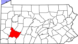
Westmoreland County, Pennsylvania County in the United States

Westmoreland County is a county located in the U.S. state of Pennsylvania. At the 2010 census, the population was 365,169. The county seat is Greensburg. Formed from, successively, Lancaster, Northumberland, and later Bedford Counties, Westmoreland County was founded on February 26, 1773, and was the first county in the colony of Pennsylvania whose entire territorial boundary was located west of the Allegheny Mountains. Westmoreland County originally included the present-day counties of Fayette, Washington, Greene, and parts of Beaver, Allegheny, Indiana, and Armstrong counties. It is named after Westmorland, a historic county of England.

Pennsylvania State of the United States of America

Pennsylvania, officially the Commonwealth of Pennsylvania, is a state located in the northeastern and Mid-Atlantic regions of the United States. The Appalachian Mountains run through its middle. The Commonwealth is bordered by Delaware to the southeast, Maryland to the south, West Virginia to the southwest, Ohio to the west, Lake Erie and the Canadian province of Ontario to the northwest, New York to the north, and New Jersey to the east.

Mount Pleasant, Pennsylvania Borough in Pennsylvania, United States

Mount Pleasant is a borough in Westmoreland County, Pennsylvania, United States. It stands 45 miles (72 km) southeast of Pittsburgh. As of the 2010 census, the borough's population was 4,454.

Related Research Articles

Neffsville, Pennsylvania Suburban community in Lancaster, Pennsylvania, United States

Neffsville is a suburban community in Manheim Township, Lancaster County, Pennsylvania. Being unincorporated, Neffsville has no boundaries. The U.S. Geological Survey Place Names database locates Neffsville at 40°6'0"N 76°18'20"W. The retailer and restaurant center of Neffsville is near 2500 Lititz Pike.

Kiskiminetas River river in western Pennsylvania

The Kiskiminetas River is a tributary of the Allegheny River, approximately 27 miles (43 km) long, in Western Pennsylvania in the United States. The region stretching from the northern side of Harmar Township, Pennsylvania to the Kiskiminetas towns is often referred to by the locals as the Alle-Kiski Valley after the rivers.

Allegheny Islands State Park

Allegheny Islands State Park is a 43-acre (17 ha) Pennsylvania state park in Harmar Township, Allegheny County, Pennsylvania in the United States. The undeveloped park is composed of three alluvial islands located in the middle of the Allegheny River northeast of Pittsburgh. The islands are just north of the boroughs of Oakmont and Plum, and southwest of Cheswick. Bridges for the Pennsylvania Turnpike and the Bessemer and Lake Erie Railroad Branch of the Canadian National Railway cross the Allegheny River at the middle island.

Kooser State Park

Kooser State Park is a 250-acre (101 ha) Pennsylvania state park in Jefferson Township, Somerset County, Pennsylvania, in the United States. The park, which borders Forbes State Forest, was built in the 1930s by the Civilian Conservation Corps, who also built the 4-acre (1.6 ha) Kooser Lake by damming Kooser Run. Kooser State Park is on Pennsylvania Route 31 a one-hour drive from Pittsburgh. The park is surrounded by Forbes State Forest.

Laurel Summit State Park

Laurel Summit State Park is a 6-acre (2.4 ha) Pennsylvania state park in Cook Township, Westmoreland County, Pennsylvania in the United States. It is also a picnic area with a scenic view of Linn Run on the summit of Laurel Mountain. The temperatures at Laurel Summit State Park are generally several degrees cooler than the surrounding towns in the valleys. The elevation of the park is 2,739 feet (835 m) above sea level.

National Register of Historic Places listings in Westmoreland County, Pennsylvania Wikimedia list article

This is a list of the National Register of Historic Places listings in Westmoreland County, Pennsylvania.

Hopewell, Westmoreland County, Pennsylvania Unincorporated community in Pennsylvania, United States

Hopewell is an unincorporated community in Westmoreland County, Pennsylvania, United States. It lies at an elevation of 1572 feet.

Alaska is a populated place in Jefferson County, Pennsylvania, United States. The name was collected by the United States Geological Survey between 1976 and 1979, and entered into the Geographic Names Information System on August 2, 1979.

Parker Ford, Pennsylvania Unincorporated community in Pennsylvania, United States

Parker Ford is an unincorporated community in East Coventry Township, Chester County, Pennsylvania, United States. Maps show it at the intersection of Pennsylvania Route 724 and Bethel Church Road/Linfield Road. Linfield Road crosses the Schuylkill River to Linfield, an unincorporated village in Limerick Township, Montgomery County.

Waddle, Pennsylvania Unincorporated community in Pennsylvania, United States

Waddle is a populated place in Patton Township, Centre County, Pennsylvania, about 3 miles (5 km) northwest of State College, and located on Buffalo Run Road.

Mifflin Cross Roads, Pennsylvania human settlement in United States of America

Mifflin Cross Roads is an unincorporated community in Beaver Township, Columbia County, Pennsylvania. It is named after Thomas Mifflin, first governor of Pennsylvania, and located three miles east of Mainville.

Bovard, Westmoreland County, Pennsylvania Unincorporated community in Pennsylvania, United States

Bovard is an unincorporated community and coal town in Hempfield Township, Westmoreland County, Pennsylvania, United States. The community is located near U.S. Route 119, 2.3 miles (3.7 km) northeast of Greensburg.

Smithdale, Pennsylvania Unincorporated community in Pennsylvania, United States

Smithdale is an unincorporated community and coal town in Allegheny County, Pennsylvania, United States. It is located in Elizabeth Township in the southeastern corner of Allegheny County, along the south bank of the Youghiogheny River. Immediately to the southeast is Collinsburg in Westmoreland County. To the north across the river is Sutersville, also in Westmoreland County.

Robinson, Indiana County, Pennsylvania Census-designated place in Pennsylvania, United States

Robinson is a census-designated place located in West Wheatfield Township, Indiana County in the state of Pennsylvania. The community is located near the Westmoreland County line and the borough of Bolivar, along Pennsylvania Route 259. As of the 2010 census the population was 614 residents.

Hartsville, Pennsylvania Populated place in Pennsylvania, United States

Hartsville is a populated place situated at the crossroads of Bristol Road and the Old York Road straddling Warminster and Warwick Township in Bucks County, Pennsylvania. It has an estimated elevation of 427 feet (130 m) above sea level. It is served by the Warminster Post Office ZIP code 18974.

Forbes Road, Pennsylvania Unincorporated community in Pennsylvania, United States

Forbes Road is an unincorporated community in Westmoreland County, Pennsylvania, United States. The community is located along Pennsylvania Route 819 3.7 miles (6.0 km) north of Greensburg. Forbes Road has a post office with ZIP code 15633, which opened on July 1, 1903.

Loux Corner, Hilltown Township, Bucks County, Pennsylvania Populated place in Pennsylvania, United States

Loux Corner is a populated place of 5 or 6 houses in Hilltown Township, Bucks County, Pennsylvania, United States. Formerly, it was known as Albrights Corner.

Westmoreland City, Pennsylvania Unincorporated community in Pennsylvania, United States

Westmoreland City is an unincorporated community located within North Huntingdon Township, Westmoreland County, Pennsylvania, United States.

Lovelton is an unincorporated populated place in North Branch Township, Wyoming County, Pennsylvania, in the United States. It is in the United States Geological Survey quadrangle of Jenningsville.

Pennsylvania State Game Lands Number 42

The Pennsylvania State Game Lands Number 42 are Pennsylvania State Game Lands in Cambria, Somerset and Westmoreland Counties in Pennsylvania in the United States providing hunting, bird watching, and other activities.

References

See also