Harrison City, Pennsylvania

Last updated

Harrison City, Pennsylvania
Downtown Harrison City, Pennsylvania - 20210227.jpg
State Route 130 in Harrison City, February 2021
USA Pennsylvania location map.svg
Red pog.svg
Harrison City, Pennsylvania
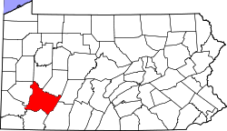
Location of Harrison City in Pennsylvania
Usa edcp location map.svg
Red pog.svg
Harrison City, Pennsylvania
Harrison City, Pennsylvania (the United States)
Coordinates: 40°21′17″N79°39′1″W / 40.35472°N 79.65028°W / 40.35472; -79.65028
CountryUnited States
StatePennsylvania
County Westmoreland
Township Penn
Elevation
991 ft (302 m)
Time zone UTC-5 (EST)
  Summer (DST) UTC-4 (EDT)
ZIP code
15636
Area code Area code 724

Harrison City is a census-designated place (CDP) in Westmoreland County, Pennsylvania, United States. The population was 174 at the 2020 census.

Contents

Geography

Harrison City is located at 40°21′17″N79°39′1″W / 40.35472°N 79.65028°W / 40.35472; -79.65028 (40.3548, -79.6502). [1]

According to the United States Census Bureau, the CDP has a total area of 0.1 square miles (0.26 km2), all land.

Demographics

As of the census [2] of 2000, there were 155 people, 75 households, and 42 families living in the CDP. The population density was 3,029.1 inhabitants per square mile (1,169.5/km2). There were 81 housing units at an average density of 1,582.9 per square mile (611.2/km2). The racial makeup of the CDP was 97.42% White, 1.94% African American, and 0.65% from two or more races. Hispanic or Latino of any race were 1.29% of the population.

There were 75 households, out of which 26.7% had children under the age of 18 living with them, 38.7% were married couples living together, 16.0% had a female householder with no husband present, and 44.0% were non-families. 44.0% of all households were made up of individuals, and 21.3% had someone living alone who was 65 years of age or older. The average household size was 2.07 and the average family size was 2.88.

In the CDP, the population was spread out, with 20.0% under the age of 18, 6.5% from 18 to 24, 23.2% from 25 to 44, 26.5% from 45 to 64, and 23.9% who were 65 years of age or older. The median age was 45 years. For every 100 females, there were 82.4 males. For every 100 females age 18 and over, there were 85.1 males.

The median income for a household in the CDP was $35,179, and the median income for a family was $36,250. Males had a median income of $28,542 versus $16,250 for females. The per capita income for the CDP was $14,759. None of the population or families were below the poverty line.

Facts

Harrison City is near the site of the Battle of Bushy Run. Penn-Trafford High School is in Harrison City, and the CDP is served by the Penn-Trafford School District. Harrison City is named after former United States President Benjamin Harrison.

Related Research Articles

Dot Lake Village is a census-designated place (CDP) in Southeast Fairbanks Census Area, Alaska, United States. The population was 62 at the 2010 census, up from 38 in 2000.

<span class="mw-page-title-main">Southern View, Illinois</span> Village in Illinois, United States

Southern View is a village in Sangamon County, Illinois, United States. The population was 1,642 at the 2010 census. It is part of the Springfield, Illinois Metropolitan Statistical Area.

<span class="mw-page-title-main">Beechwood Trails, Ohio</span> Census-designated place in Ohio, United States

Beechwood Trails is a census-designated place (CDP) in Harrison Township, Licking County, Ohio, United States. The population was 3,276 at the 2020 census.

<span class="mw-page-title-main">Russellton, Pennsylvania</span> Census-designated place in Pennsylvania, United States

Russellton is a census-designated place (CDP) in Allegheny County, Pennsylvania, United States. The population was 1,330 at the 2020 census.

<span class="mw-page-title-main">Lenape Heights, Pennsylvania</span> Census-designated place in Pennsylvania, United States

Lenape Heights is a census-designated place (CDP) in Armstrong County, Pennsylvania, United States. The population was 1,144 at the 2020 census.

<span class="mw-page-title-main">Orchard Hills, Pennsylvania</span> Census-designated place in Pennsylvania, United States

Orchard Hills is a census-designated place (CDP) in Armstrong County, Pennsylvania, United States. The population was 1,949 at the 2020 census.

<span class="mw-page-title-main">West Hills, Pennsylvania</span> Census-designated place in Pennsylvania, United States

West Hills is a census-designated place (CDP) in Armstrong County, Pennsylvania, United States. The population was 1,228 at the 2020 census.

<span class="mw-page-title-main">Meadowood, Pennsylvania</span> Census-designated place in Pennsylvania, United States

Meadowood is a census-designated place (CDP) in Butler County, Pennsylvania, United States. The population was 2,693 at the 2010 census.

<span class="mw-page-title-main">Meridian, Pennsylvania</span> Census-designated place in Pennsylvania, United States

Meridian is a census-designated place (CDP) in Butler County, Pennsylvania, United States. The population was 3,881 at the 2010 census.

<span class="mw-page-title-main">East Uniontown, Pennsylvania</span> Census-designated place in Pennsylvania, United States

East Uniontown is a census-designated place (CDP) in Fayette County, Pennsylvania, United States. The population was 2,419 at the 2010 census, down from 2,760 at the 2000 census.

Jacksonville is a census-designated place (CDP) in Indiana County, Pennsylvania, United States. The population was 637 at the 2010 census. It was formerly an independent borough, until January 1, 1993 when it was returned to Black Lick Township, Pennsylvania.

<span class="mw-page-title-main">Lucerne Mines, Pennsylvania</span> Census-designated place in Pennsylvania, United States

Lucernemines, usually written as Lucerne Mines, is a census-designated place (CDP) in Indiana County, Pennsylvania, United States. The population was 937 at the 2010 census.

<span class="mw-page-title-main">Mexico, Juniata County, Pennsylvania</span> Census-designated place in Pennsylvania, United States

Mexico is an unincorporated community and census-designated place (CDP) in Walker Township, Juniata County, Pennsylvania, United States.

Hasson Heights is a census-designated place (CDP) in Venango County, Pennsylvania, United States. The population was 1,351 at the 2010 census.

<span class="mw-page-title-main">Baidland, Pennsylvania</span> Census-designated place in Pennsylvania, United States

Baidland is a census-designated place (CDP) in Washington County, Pennsylvania, United States. The population was 1,563 at the 2010 census.

<span class="mw-page-title-main">Wickerham Manor-Fisher, Pennsylvania</span> Census-designated place in Pennsylvania, United States

Wickerham Manor-Fisher is a census-designated place (CDP) in Washington County, Pennsylvania, United States. The population was 1,728 at the 2010 census.

Lawson Heights is a census-designated place (CDP) in Unity Township, Westmoreland County, Pennsylvania, United States. The population was 2,339 at the 2000 census.

Loyalhanna is a census-designated place (CDP) in Westmoreland County, Pennsylvania, United States. The population was 3,415 at the 2000 census, at which time it was listed as McChesneytown-Loyalhanna, before just becoming the CDP of Loyalhanna for the 2010 census. As of the 2010 census the population was 3,428 residents.

<span class="mw-page-title-main">Slickville, Pennsylvania</span> CDP in Pennsylvania, United States

Slickville is a census-designated place (CDP) in Westmoreland County, Pennsylvania, United States. The population was 372 at the 2000 census.

<span class="mw-page-title-main">Veradale, Washington</span> Locale in Washington, United States

Veradale—originally known as Vera—is a locale and former census-designated place in Spokane County, Washington, United States. The population was 9,387 at the 2000 census. Veradale retains its own post office.

References

  1. "Harrison City Census Designated Place". Geographic Names Information System . United States Geological Survey, United States Department of the Interior . Retrieved May 3, 2009.
  2. "U.S. Census website". United States Census Bureau . Retrieved January 31, 2008.