List of Pittsburgh neighborhoods

Last updated

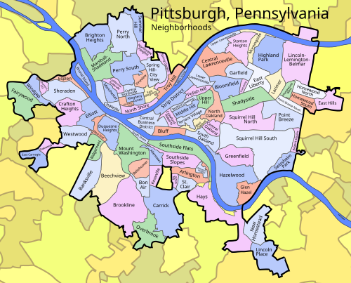
This is a list of 90 neighborhoods in the city of Pittsburgh, Pennsylvania, United States. Generally neighborhood development followed ward boundaries, although the City Planning Commission has defined some neighborhood areas. [1] The map of neighborhoods presented here is based on the official designations from the City of Pittsburgh. [2]

Contents

Neighborhoods

Click a neighborhood to navigate to its article. Pittsburgh Pennsylvania neighborhoods.svgSquirrel Hill SouthGreenfieldHazelwoodGlen HazelHaysLincoln PlaceSt. ClairArlingtonArlington HeightsMt. OliverCarrickOverbrookBrooklineBon AirBeltzhooverKnoxvilleBeechviewMt. WashingtonAllentownSouth ShoreDuquesne HeightsBanksvilleSwisshelm ParkRidgemontWest EndWestwoodOakwoodEast CarnegieElliottCrafton HeightsSheradenEsplenChartiers CityWindgapFairywoodRegent SquarePoint BreezePoint Breeze NorthHomewood WestHomewood SouthEast HillsHomewood NorthLarimerSquirrel Hill NorthShadysideSouth OaklandCentral OaklandNorth OaklandWest OaklandBluffCentral Business DistrictStrip DistrictCrawford-RobertsBedford DwellingsMiddle HillTerrace VillagePolish HillHighland ParkLower LawrencevilleUpper HillCentral LawrencevilleUpper LawrencevilleStanton HeightsMorningsideBloomfieldGarfieldFriendshipEast LibertyHerrs IslandBrunot IslandNorth ShoreTroy HillChateauManchesterCalifornia-KirkbrideAllegheny WestAllegheny CenterCentral NorthsideEast AlleghenyFineviewSpring GardenSpring Hill–City ViewNorthview HeightsPerry SouthMarshall-ShadelandBrighton HeightsPerry NorthSummer Hill
Click a neighborhood to navigate to its article.

Areas

List of municipalities annexed

[3]

See also

Related Research Articles

<span class="mw-page-title-main">Allegheny County, Pennsylvania</span> County in Pennsylvania, United States

Allegheny County is a county in Pennsylvania, United States. As of the 2020 census, the population was 1,250,578, making it the state's second-most populous county, after Philadelphia County. Its county seat and most populous city is Pittsburgh, Pennsylvania's second most populous city. The county is part of the Greater Pittsburgh region of the commonwealth, and is the center of the Pittsburgh media market.

<span class="mw-page-title-main">Carnegie Library of Pittsburgh</span> Public library system in Pittsburgh, Pennsylvania

The Carnegie Library of Pittsburgh is the public library system in Pittsburgh, Pennsylvania. Its main branch is located in the Oakland neighborhood of Pittsburgh, and it has 19 branch locations throughout the city. Like hundreds of other Carnegie libraries, the construction of the main library, which opened in 1895, and several neighborhood branches, was funded by industrialist Andrew Carnegie. The Pittsburgh area houses the first branches in the United States.

<span class="mw-page-title-main">Brookline (Pittsburgh)</span> Neighborhood of Pittsburgh in Allegheny County, Pennsylvania, United States

Brookline is a neighborhood in the South Hills of Pittsburgh, Pennsylvania, United States. It takes its name from the town in Massachusetts, which early settlers felt bore a resemblance to the area.

<span class="mw-page-title-main">Pittsburgh Regional Transit</span> Public transit agency in Pennsylvania, US

Pittsburgh Regional Transit (PRT) is the public agency responsible for most public transportation services in the Greater Pittsburgh region in Pennsylvania. It is the second-largest public transit agency in Pennsylvania and the 20th-largest in the United States. PRT operates an integrated system of bus, light rail and funicular services in Pittsburgh and Allegheny County, with limited service to three adjacent counties in the Greater Pittsburgh region. The agency was founded in 1956 as the Port Authority of Allegheny County, and began operating transit service in 1964. PRT pioneered bus rapid transit in the United States with the opening of the South Busway in 1977, and continues to operate bus rapid transit services as a core part of its network. In 2023, the system had a ridership of 39,730,300.

<span class="mw-page-title-main">Bon Air (Pittsburgh)</span> Neighborhood of Pittsburgh in Allegheny County, Pennsylvania, United States

Bon Air is a neighborhood in the south portion of Pittsburgh, Pennsylvania, United States. Its two zip codes are 15226 and 15210, and it is represented in the Pittsburgh City Council by the council member for District 4.

<span class="mw-page-title-main">Duquesne Heights</span> Neighborhood of Pittsburgh in Allegheny County, Pennsylvania, United States

Duquesne Heights is a neighborhood in Pittsburgh, Pennsylvania's south city area. It has a zip code of 15211, and has representation on Pittsburgh City Council by the council member for District 2.

<span class="mw-page-title-main">Knoxville (Pittsburgh)</span> Neighborhood of Pittsburgh in Allegheny County, Pennsylvania, United States

Knoxville is a neighborhood in southern Pittsburgh, Pennsylvania, United States. It is part of zip code 15210, and has representation on Pittsburgh City Council by the council member for District 3.

<span class="mw-page-title-main">Pittsburgh Railways</span>

Pittsburgh Railways was one of the predecessors of Pittsburgh Regional Transit. It had 666 PCC cars, the third largest fleet in North America. It had 68 streetcar routes, of which only three are used by the Port Authority as light rail routes. With the Port Authority's Transit Development Plan, many route names will be changed to its original, such as the 41D Brookline becoming the 39 Brookline. Many of the streetcar routes have been remembered in the route names of many Port Authority buses.

<span class="mw-page-title-main">Transportation in Pittsburgh</span> Transportation in Pittsburgh, Pennsylvania, United States

A large metropolitan area that is surrounded by rivers and hills, Pittsburgh has an infrastructure system that has been built out over the years to include roads, tunnels, bridges, railroads, inclines, bike paths, and stairways; however, the hills and rivers still form many barriers to transportation within the city.

<span class="mw-page-title-main">Union Railroad (Pittsburgh)</span>

Union Railroad is a Class III switching railroad located in Allegheny County in Western Pennsylvania. The company is owned by Transtar, Inc., which is a subsidiary of Fortress Transportation and Infrastructure Investors, after being acquired from U.S. Steel in 2021. The railroad's primary customers are the three plants of the USS Mon Valley Works, the USS Edgar Thomson Steel Works, the USS Irvin Plant and the USS Clairton Coke Works.

Brashear High School is a large, urban, magnet, public school in the Beechview neighborhood of Pittsburgh, Pennsylvania, United States. Brashear is one of four high schools in the Pittsburgh Public Schools. In the 2010–2011 school year, the school had 1,214 pupils with 615 males and 566 females. It employed 87 teachers. Since then, the school has acquired students from the transition with Langley High School. It is currently the largest high school in the district, with approximately 1,480 students and 105 teachers.

<span class="mw-page-title-main">Pittsburgh Light Rail</span> Light rail system in Pittsburgh, Pennsylvania

The Pittsburgh Light Rail is a 26.2-mile (42.2 km) light rail system in Pittsburgh, Pennsylvania, and surrounding suburbs. It operates as a deep-level subway in Downtown Pittsburgh, but runs mostly at-grade in the suburbs south of the city. The system is largely linear in a north-south direction, with one terminus near Pittsburgh's central business district and two termini in the South Hills. The system is owned and operated by Pittsburgh Regional Transit.

<span class="mw-page-title-main">Red Line (Pittsburgh)</span> Light rail line in Pittsburgh, Pennsylvania

The Red Line is a line on the Pittsburgh Light Rail system that runs between South Hills Village and Downtown Pittsburgh via the Beechview neighborhood. The companion route, the Blue Line, branches off north of Martin Villa – which closed in 2012 – and runs through Overbrook. In March 2007, the closure of the Palm Garden Bridge for refurbishment suspended the Red Line for five months; it resumed service in September.

West Liberty Borough was a borough in Allegheny County, Pennsylvania, United States from 1876 to 1909. West Liberty Borough was incorporated on March 7, 1876 from the western part of Lower St. Clair Township. The borough was a small village along the Pittsburgh and Washington Road near Mount Washington. West Liberty Borough was absorbed by the city of Pittsburgh in 1909. It is today the Brookline neighborhood, Bon Air neighborhood, and part of the Beechview neighborhood.

<span class="mw-page-title-main">Longfellow, Alden & Harlow</span>

Longfellow, Alden & Harlow, of Boston, Massachusetts, and Pittsburgh, Pennsylvania, was the architectural firm of Alexander Wadsworth Longfellow Jr. (1854–1934), Frank Ellis Alden (1859–1908), and Alfred Branch Harlow (1857–1927). The firm, successors to H. H. Richardson, continued to provide structures in the Romanesque revival style established by Richardson that is often referred to as Richardsonian Romanesque.

<span class="mw-page-title-main">South Busway</span> Busway in Pittsburgh, Pennsylvania

The South Busway is a two-lane bus rapid transit highway serving southern portions of the city of Pittsburgh. The busway runs for 4.3 miles (6.9 km) from the Mt. Washington Transit Tunnel across the Monongahela River from Downtown Pittsburgh to the Overbrook neighborhood of the city, bypassing the crowded Pennsylvania Route 51. It is owned and maintained by Pittsburgh Regional Transit, the public transit provider for Allegheny County and the Pittsburgh region.

<span class="mw-page-title-main">Thomas Hannah</span> American architect

Thomas Hannah (1867–1935) was a Scottish-American architect based in Pittsburgh in the United States. He is credited with designing the Saint Nicholas Greek Orthodox Cathedral. He also designed the Western Theological Seminary in Pittsburgh. He also designed Midtown Towers, originally known as the Keenan Building and built in 1907. It was built for Colonel Thomas J. Keenan, owner and founder of the Penny Press, which became Pittsburgh Press. The building may have been modeled after the Spreckel Building/ Call Building (1898) of San Francisco. It is decorated with visages of 10 notables associated with Pittsburgh and Pennsylvania, including then-mayor George Guthrie and then-governor Edwin Stuart, in addition to George Washington and Teddy Roosevelt. The dome was once capped with the figure of an eagle in flight.

<span class="mw-page-title-main">Blue Line (Pittsburgh)</span> Light rail line in Pittsburgh, Pennsylvania

The Blue Line is a Pittsburgh Light Rail line that runs between Downtown Pittsburgh via the Overbrook neighborhood to South Hills Village.

<span class="mw-page-title-main">Mount Washington, Pittsburgh (neighborhood)</span> Place in Pennsylvania, United States

Mount Washington is a neighborhood in the southern region of Pittsburgh, Pennsylvania. It has a Zip Code of 15211 and has representation on Pittsburgh City Council by both the council members for District 3 and District 2.

<span class="mw-page-title-main">Silver Line (Pittsburgh)</span> Light rail line in Pittsburgh, Pennsylvania

The Silver Line is a line on the Pittsburgh Light Rail system that runs between Downtown Pittsburgh through the Overbrook neighborhood to Library. It is the renamed service for the former Blue Line –Library branch.

References

  1. Jones, Diana N. (June 5, 2006). "Defining city neighborhoods an imprecise process". Pittsburgh Post-Gazette . Retrieved December 7, 2009.
  2. "Geographic Information Systems - Pittsburgh Map Room". City of Pittsburgh. Retrieved September 16, 2014.
  3. "The Growth of Pittsburgh: Annexation and Population".