Mexican War Streets Historic District | |
 | |
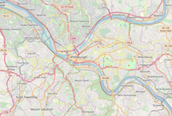   | |
| Location | Irregular pattern between Buena Vista to the north and North Ave. to Reddour St. (increase), Pittsburgh, Pennsylvania |
|---|---|
| Coordinates | 40°27′21.23″N80°0′41.40″W / 40.4558972°N 80.0115000°W |
| Area | 27 acres (11 ha) (original) 25.7 acres (10.4 ha) (increase) |
| Architectural style | Late 19th and 20th Century Revivals, Greek Revival, Late Victorian (original) Greek Revival, Italianate, Romanesque, Second Empire (increase) |
| NRHP reference No. | 75001612 and 08000845 [1] |
| Significant dates | |
| Added to NRHP | May 28, 1975 (original) September 4, 2008 (increase) |
| Designated CPHD | December 26, 1972 [2] |
| Designated PHLF | 1976 [3] |
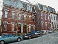
The Mexican War Streets, originally known as the "Buena Vista Tract," is a historic district in the Central Northside neighborhood of Pittsburgh, Pennsylvania, United States. The district is densely filled with restored row houses, community gardens, and tree-lined streets and alleyways. The area dates to around the time of the Mexican–American War and a number of streets are named after battles and generals of the war. [4]