North Point Breeze

Last updated
North Point Breeze
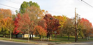
Westinghouse Park.jpg
A view of Westinghouse Park from the south-east.
Pgh locator point breeze north.svg
Coordinates: 40°27′07″N79°54′07″W / 40.452°N 79.902°W / 40.452; -79.902
Country United States
State Pennsylvania
County Allegheny County
City Pittsburgh
Area
[1]
  Total0.286 sq mi (0.74 km2)
Population
 (2010) [1]
  Total2,054
  Density7,200/sq mi (2,800/km2)

North Point Breeze (or Point Breeze North) is a mostly residential neighborhood that is located in the East End of Pittsburgh, Pennsylvania. It has a zip code of 15208, and representation on Pittsburgh City Council by the council member for District 9 (Northeast Neighborhoods).

Contents

History and notable features

This neighborhood was the site of the estate of the entrepreneur George Westinghouse, which was converted into Westinghouse Park after 1918, as well as the 'Greenlawn' estate of Henry J. Heinz, located one block south. The H.J. Heinz property was subdivided into residential lots after the mansion was knocked down, but the original carriage house was converted into an apartment building and remains standing on what is now Meade Place. [2] The stone wall that stood at the perimeter of the original Heinz estate remains standing, along with a decorative iron fence along Penn Avenue.

Fifth Avenue borders the western end of the neighborhood, with the nearby Bakery Square development and Mellon Park. Along its northern border is a Norfolk Southern Railway line and the Martin Luther King Jr. East Busway, with a stop at North Homewood Avenue serving the neighborhood.

The eastern side of the neighborhood is home to light-industry and commercial businesses, including the Construction Junction architectural-reuse center, as well as the Allegheny County and City of Pittsburgh 9-1-1 call center. Shady Lane School, a leading area preschool first established in 1966 in the nearby Shadyside neighborhood, has been set at the corners of Penn and North Braddock Avenues since 1992. [3] There's also a food coop, a rental-storage warehouse, in addition to a small residential enclave. Historically, the short-lived Penn Motor Car Company operated on Thomas Boulevard from 1910 to 1912.

The Point Breeze North Development Corporation is the local neighborhood association, promoting real estate, historic preservation, and public safety issues.

Both of writer John Edgar Wideman's memoirs, Brothers and Keepers and Hoop Roots, use Westinghouse Park as a setting, as does his fictional Homewood Trilogy.

Surrounding neighborhoods

North Point Breeze has five borders, four with the Pittsburgh neighborhoods of Homewood West and Homewood South to the north, Point Breeze to the south, and Larimer to the west. The other border is with the borough of Wilkinsburg to the east. North Point Breeze also runs catty-corner with the Pittsburgh neighborhood of Shadyside to the west at the intersection of Penn and Fifth Avenues (This intersection also serves as a north-south "diagonal" for the Pittsburgh neighborhoods of Larimer and Point Breeze).

See also

Related Research Articles

<span class="mw-page-title-main">Squirrel Hill</span> Neighborhood of Pittsburgh in Allegheny County, Pennsylvania, United States

Squirrel Hill is a residential neighborhood in the East End of Pittsburgh, Pennsylvania, United States. The city officially divides it into two neighborhoods, Squirrel Hill North and Squirrel Hill South, but it is almost universally treated as a single neighborhood.

<span class="mw-page-title-main">Oakland (Pittsburgh)</span> Place in Pennsylvania, United States

Oakland is the academic and healthcare center of Pittsburgh and one of the city's major cultural centers. Home to three universities, museums, hospitals, shopping venues, restaurants, and recreational activities, this section of the city also includes two city-designated historic districts: the mostly residential Schenley Farms Historic District and the predominantly institutional Oakland Civic Center Historic District, as well as the locally-designated Oakland Square Historic District.

<span class="mw-page-title-main">Downtown Pittsburgh</span> Neighborhood of Pittsburgh in Allegheny County, Pennsylvania, United States

Downtown Pittsburgh, colloquially referred to as the Golden Triangle, and officially the Central Business District, is the urban downtown center of Pittsburgh. It is located at the confluence of the Allegheny River and the Monongahela River whose joining forms the Ohio River. The triangle is bounded by the two rivers.

<span class="mw-page-title-main">Friendship (Pittsburgh)</span> Neighborhood of Pittsburgh in Allegheny County, Pennsylvania, United States

Friendship is a neighborhood of large Victorian houses in the East End of the City of Pittsburgh, Pennsylvania, United States, about four miles (6 km) east of Pittsburgh's Golden Triangle. Friendship is bordered on the north by Garfield, on the east by East Liberty, on the south by Shadyside, and on the west by Bloomfield. It is divided into three Pittsburgh City Council districts.

<span class="mw-page-title-main">Homewood (Pittsburgh)</span> Neighborhood of Pittsburgh in Allegheny County, Pennsylvania, United States

Homewood is a predominantly African-American neighborhood of Pittsburgh, Pennsylvania, United States, officially divided into three neighborhoods: Homewood North, Homewood South and Homewood West.

<span class="mw-page-title-main">Highland Park (Pittsburgh neighborhood)</span> Neighborhood of Pittsburgh in Allegheny County, Pennsylvania, United States

Highland Park is a neighborhood in the northeastern part of Pittsburgh, Pennsylvania. Highland Park, the neighborhood, fully encompasses the park with the same name.

<span class="mw-page-title-main">Lincoln–Lemington–Belmar</span> Neighborhood of Pittsburgh in Allegheny County, Pennsylvania, United States

Lincoln–Lemington–Belmar is a neighborhood in Pittsburgh, Pennsylvania. It is located in the northeastern section of the city and spans the Allegheny River. Lincoln–Lemington–Belmar houses PBF 15 Engine, and is covered by PBP Zone 5 and the Bureau of EMS Medic 1.

<span class="mw-page-title-main">East Liberty (Pittsburgh)</span> Neighborhood of Pittsburgh in Allegheny County, Pennsylvania, United States

East Liberty is a neighborhood in Pittsburgh, Pennsylvania's East End. It is bordered by Highland Park, Morningside, Stanton Heights, Garfield, Friendship, Shadyside and Larimer, and is represented on Pittsburgh City Council by Councilwoman Deborah Gross and Rev. Ricky Burgess. One of the most notable features in the East Liberty skyline is the East Liberty Presbyterian Church, which is an area landmark.

<span class="mw-page-title-main">Larimer (Pittsburgh)</span> Neighborhood of Pittsburgh in Allegheny County, Pennsylvania, United States

Larimer is a neighborhood in the East End of the City of Pittsburgh, Pennsylvania in the United States. The neighborhood takes its name from William Larimer, who grew up in nearby Westmoreland County and, after making a fortune in the railroad industry, built a manor house overlooking East Liberty along a path that came to be called "Larimer Lane" and later Larimer Avenue.

<span class="mw-page-title-main">Point Breeze, Pittsburgh</span> Neighborhood of Pittsburgh in Allegheny County, Pennsylvania, United States

Point Breeze, or South Point Breeze, is a largely residential neighborhood in Pittsburgh, Pennsylvania, USA. The community was named after a tavern once located there.

<span class="mw-page-title-main">East Hills (Pittsburgh)</span> Neighborhood in Pittsburgh

East Hills is a neighborhood in the east side of Pittsburgh, Pennsylvania, United States. Its ZIP Code is 15221. It has representation on Pittsburgh City Council by the council member for District 9.

<span class="mw-page-title-main">Regent Square (Pittsburgh)</span> Neighborhood of Pittsburgh in Allegheny County, Pennsylvania, United States

Regent Square is a neighborhood in the East End of Pittsburgh, Pennsylvania, United States. According to its civic association, it "includes portions of the municipalities of Pittsburgh, Edgewood, Swissvale and Wilkinsburg". It is also the name of one of the 90 neighborhoods within the City of Pittsburgh's limits, which leads to some confusion among residents. In 2017, it was named the #1 neighborhood to live in Pittsburgh and the #17 best neighborhood in the United States by Niche.com.

<span class="mw-page-title-main">Shadyside (Pittsburgh)</span> Neighborhood of Pittsburgh in Allegheny County, Pennsylvania, United States

Shadyside is a neighborhood in the East End of Pittsburgh, Pennsylvania, United States. It has three zip codes and representation on Pittsburgh City Council by the council member for District 8. Shadyside is drawn from the name of a 19th-century Pennsylvania Railroad station in the area, which was named for its shady lanes.

<span class="mw-page-title-main">Westinghouse Park</span>

Westinghouse Park is a city-block sized municipal park in Pittsburgh, Pennsylvania.

<span class="mw-page-title-main">Pennsylvania Route 380</span> State highway in Pennsylvania, US

Pennsylvania Route 380, also known as J.F. Bonetto Memorial Highway and within the city of Pittsburgh Bigelow Boulevard, Baum Boulevard and Frankstown Road, is a 32.80 mi (52.8 km) long state highway in western portions of the U.S. state of Pennsylvania. The western terminus of the route is at Interstate 579 in downtown Pittsburgh near PPG Paints Arena. The eastern terminus is at Pennsylvania Route 286 in Bell Township, near the hamlet of Wakena.

<span class="mw-page-title-main">Frederick G. Scheibler Jr.</span> American architect

Frederick Gustavus Scheibler Jr. was an American architect.

<span class="mw-page-title-main">Pennsylvania Route 130</span> State highway in Pennsylvania, US

Pennsylvania Route 130 (PA 130) is a 49-mile-long (79 km) state highway located in Allegheny and Westmoreland counties in Pennsylvania. The western terminus is at PA 8 in Pittsburgh, and the eastern terminus is at PA 381 near Kregar.

<span class="mw-page-title-main">Fifth Avenue (Pittsburgh)</span>

Fifth Avenue is one of the longest streets in Pittsburgh, Pennsylvania, United States. It begins downtown and moves eastward for over five miles (9 km). Fifth Avenue passes by the Carlow University, the Cathedral of Learning and other buildings of the University of Pittsburgh, then forms the borders between Shadyside on the north and Squirrel Hill and Point Breeze to the south. Finally, after passing Chatham University, The Ellis School, and Mellon Park, it turns north and forms the border between Larimer on the west and North Point Breeze and Homewood (Pittsburgh) on the east. At the intersection with Frankstown Avenue its name becomes Washington Boulevard and descends a branch of Negley Run to meet Allegheny River Boulevard near the Highland Park Bridge.

Ellsworth Avenue is located in the Shadyside neighborhood of Pittsburgh, Pennsylvania. It is mostly a commercial street that has locally owned businesses, galleries, restaurants, and bars. It runs southwest-northeast, parallel to Walnut Street, another commercial street, and is bounded by Shady Avenue to the east and South Neville Street to the west. Ellsworth Avenue is one of Shadyside's three business districts, along with South Highland Avenue and Walnut Street.

References

  1. 1 2 "PGHSNAP 2010 Raw Census Data by Neighborhood". Pittsburgh Department of City Planning PGHSNAP Utility. 2012. Retrieved 24 June 2013.{{cite news}}: External link in |publisher= (help)
  2. "Wikimapia - Let's describe the whole world!".
  3. "Pittsburgh Preschool: Shady Lane". www.shadylane.org. Archived from the original on 2008-11-20.