Troy Hill (Pittsburgh)

Last updated
Troy Hill
Troy Hill North East.jpg
View of Troy Hill from North East April 2014
Pgh locator troy hill.svg
Coordinates: 40°28′N79°59′W / 40.47°N 79.98°W / 40.47; -79.98
Country United States
State Pennsylvania
County Allegheny County
City Pittsburgh
Area
  Total0.46 sq mi (1.2 km2)
Population
 (2010) [1]
  Total2,714
  Density5,900/sq mi (2,300/km2)
ZIP Code
15212

Troy Hill is a neighborhood on Pittsburgh, Pennsylvania's North Side. It has a zip code of 15212, and has representation on Pittsburgh City Council by the council member for District 1.

Contents

Troy Hill sits on a plateau above the Allegheny River. It is approximately 3 kilometers (1.9 mi) long from Vinial Street to the end of Lowrie Street and only 1 kilometer (0.62 mi) wide from Wicklines Lane to Herrs Island.

History

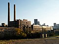
Troy Hill was originally part of the Reserve Tract laid out by surveyor and Pennsylvania Vice-President David Redick in 1788. Incorporated in 1833 as the village of New Troy, it was settled by German immigrants who worked in the mills, tanneries, breweries, and railroads that lined the Allegheny River. The migration up to Troy Hill began when a Catholic church opened a small cemetery in 1842. By 1866 one hundred families were officially Troy Hill residents. The adjacent riverfront land along with Herr's Island would in 1849 be incorporated into the short-lived Duquesne borough (distinct from the modern borough of the same name), that in 1868 was partitioned, the portion upriver of the northern end of Herr's Island becoming part of the newly-formed borough of Millvale, while the downriver portion including the island was annexed to the City of Allegheny as its 8th ward. The upland including the village of Troy Hill was also annexed, forming part of the 7th ward, and following an 1877 redistricting became the city's 13th ward. When Allegheny was annexed by Pittsburgh in 1907, most of its 8th and 13th wards became Pittsburgh's 24th ward, roughly corresponding to the modern Troy Hill neighborhood.

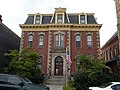
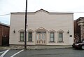
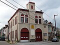
Troy Hill is home to six historic landmarks: the Troy Hill Firehouse, Saint Anthony's Chapel, the Rectory of Most Holy Name of Jesus, the Troy Hill Incline Building, the Allegheny Reservoir Wall, and the Ober-Guehl house.

In the 1830s, Troy Hill's population escalated significantly, resulting in the need of a school. In 1836, a 1-room brick school house was built in "New Troy" and named Mount Troy School #1, because at the time it was located in Reserve Township. It was sold in 1860, which then was replaced by a new, 2 room brick school house. A decade after the civil war, the pupils increased to around 200, so 2 more rooms were added in 1874. Troy Hill was now part of Allegheny's School System, and in 1883 the school was demolished and a new one was built in its place. That building was then also replaced by the Troy Hill School of 1907, but then was shut down in 1960 and demolished. The site of the original school is now a community park. [2]

Troy Hill was the home to Commissioner Thomas J. Foerster who served 10 years in the state house and 28 years as the Commissioner of Allegheny County. He also served on the first county council established in 2000. Another notable resident was Andrew (Huck) Fenrich who served 9 terms in the state house, was executive secretary for the mayor of Pittsburgh, and also served as executive secretary for the Allegheny County Democrats.

Until 1959 the neighborhood was served by the 4 Troy Hill trolley operated by Pittsburgh Railways. [3]

Beginning in 2013, Evan Mirapaul, an art collector living in Troy Hill, commissioned two whole-house installations in the neighborhood. Both La Hutte Royal, created by German artist Thorsten Brinkmann, and Kunzhaus, by Polish artist Robert Kusmirowski, are free to tour by appointment. [4]

Historical population
YearPop.±%
1940 7,319    
1950 6,530−10.8%
1960 5,141−21.3%
1970 4,205−18.2%
1980 3,251−22.7%
1990 2,742−15.7%
2000 2,540−7.4%
2010 2,714+6.9%
Source: PGHSNAP Census Data [5]

Other names

While "Troy Hill" generally refers to the historically German neighborhood atop the Troy Hill plateau, the neighborhood's boundaries also encompass the narrow and flat river plain that sits between the plateau and the Allegheny River, formerly part of the Borough of Duquesne. As of 2011, this river plain is dominated by Pennsylvania Route 28, an expressway which begins at East Ohio Street and then follows the river north. But before Route 28 became an expressway, this plain was a Croatian neighborhood that was settled by immigrants from Jastrebarsko, who called the neighborhood "Mala Jaska" and founded St. Nicholas Parish, [6] [7] and "Bohemian Hill" to the Southwest.

Troy Hill in Hollywood Films

Several Hollywood films have scenes filmed in Troy Hill, including Hoffa (1992), [8] Innocent Blood (1992), [8] Striking Distance (1993), [9] and Adventureland (2009). [9]

Surrounding and adjacent neighborhoods

Troy Hill has five borders including the Pittsburgh neighborhoods of Spring Garden to the north and northwest, East Allegheny to the west, and North Shore to the southwest as well as Reserve Township to the north-northwest and the borough of Millvale to the northeast. Troy Hill is also adjacent to the Strip District across the Allegheny River with a direct link via 31st Street Bridge.

City Steps

The Troy Hill neighborhood has 11 distinct flights of city steps, many of which are open and in a safe condition. In Troy Hill, the Steps of Pittsburgh quickly connect pedestrians to public transportation and the East Ohio Street trail. [10]

See also

Related Research Articles

<span class="mw-page-title-main">Millvale, Pennsylvania</span> Borough in Pennsylvania, United States

Millvale is a borough in Allegheny County, Pennsylvania, United States, along the Allegheny River, opposite Pittsburgh. The borough is located off Pennsylvania Route 28. The population was 3,376 at the 2020 census.

<span class="mw-page-title-main">Oakland (Pittsburgh)</span> Place in Pennsylvania, United States

Oakland is the academic and healthcare center of Pittsburgh and one of the city's major cultural centers. Home to three universities, museums, hospitals, shopping venues, restaurants, and recreational activities, this section of the city also includes two city-designated historic districts: the mostly residential Schenley Farms Historic District and the predominantly institutional Oakland Civic Center Historic District, as well as the locally-designated Oakland Square Historic District.

<span class="mw-page-title-main">Greenfield (Pittsburgh)</span> Neighborhood of Pittsburgh in Allegheny County, Pennsylvania, United States

Greenfield is a neighborhood in Pittsburgh, Pennsylvania, United States. It is represented on Pittsburgh City Council by Barb Warwick.

<span class="mw-page-title-main">Downtown Pittsburgh</span> Neighborhood in Allegheny County, Pennsylvania, United States

Downtown Pittsburgh, colloquially referred to as the Golden Triangle, and officially the Central Business District, is the urban downtown center of Pittsburgh, Pennsylvania, United States. It is located at the confluence of the Allegheny River and the Monongahela River whose joining forms the Ohio River. The triangle is bounded by the two rivers.

<span class="mw-page-title-main">Allegheny, Pennsylvania</span> Former city in Pennsylvania, United States

Allegheny City was a municipality that existed in the U.S. state of Pennsylvania from 1788 until it was annexed by Pittsburgh in 1907. It was located north across the Allegheny River from downtown Pittsburgh, with its southwest border formed by the Ohio River, and is known today as the North Side. The city's waterfront district, along the Allegheny and Ohio rivers, became Pittsburgh's North Shore neighborhood.

<span class="mw-page-title-main">Highland Park (Pittsburgh neighborhood)</span> Neighborhood of Pittsburgh in Allegheny County, Pennsylvania, United States

Highland Park is a neighborhood in the northeastern part of Pittsburgh, Pennsylvania. Highland Park, the neighborhood, fully encompasses the park with the same name.

<span class="mw-page-title-main">Lincoln–Lemington–Belmar</span> Neighborhood of Pittsburgh in Allegheny County, Pennsylvania, United States

Lincoln–Lemington–Belmar is a neighborhood in Pittsburgh, Pennsylvania. It is located in the northeastern section of the city and spans the Allegheny River. Lincoln–Lemington–Belmar houses PBF 15 Engine, and is covered by PBP Zone 5 and the Bureau of EMS Medic 1.

<span class="mw-page-title-main">California-Kirkbride</span> Neighborhood of Pittsburgh in Allegheny County, Pennsylvania, United States

California-Kirkbride is a neighborhood on Pittsburgh, Pennsylvania's North Side.

<span class="mw-page-title-main">Banksville (Pittsburgh)</span> Neighborhood of Pittsburgh in Allegheny County, Pennsylvania, United States

Banksville is a neighborhood in Pittsburgh, Pennsylvania. The neighborhood of Banksville is located in the West End of the city and borders the South Hills region. Real estate agencies frequently refer to the Banksville area as Greentree City due to Banksville's shared border with the borough of Green Tree. It has two zip codes of both 15220 and 15216, and has representation in Pittsburgh City Council by the council member for District 2. Theresa Kail-Smith is the current Councilperson for district two. Banksville's primary corridor, Banksville Road, is frequently used as a gateway between the South Hills of Pittsburgh and downtown Pittsburgh via the Fort Pitt Tunnels. Banksville, formerly Union Township, joined the City of Pittsburgh around 1928.

<span class="mw-page-title-main">Central Lawrenceville</span> Neighborhood of Pittsburgh in Allegheny County, Pennsylvania, United States

Central Lawrenceville is a neighborhood in the northeast of Pittsburgh, Pennsylvania in the United States. It has a zip code of 15201, and has representation on Pittsburgh City Council by the council member for District 7. It is home to Allegheny Cemetery. Central Lawrenceville is the home of the Pittsburgh Bureau of Fire's 6 Engine and 6 Truck.

<span class="mw-page-title-main">Central Northside</span> Neighborhood of Pittsburgh in Allegheny County, Pennsylvania, United States

Central Northside is a neighborhood in the North Side of the city of Pittsburgh, Pennsylvania, USA. It has a zip code of 15212, and has representation on Pittsburgh City Council by the council member for District 6. Originally known as "The Buena Vista Tract", it is densely filled with restored row houses, community gardens and tree lined streets and alleyways.

<span class="mw-page-title-main">East Allegheny</span> Neighborhood of Pittsburgh in Allegheny County, Pennsylvania, United States

East Allegheny, also known as Deutschtown, is a neighborhood on Pittsburgh's North Side. It has a ZIP code of 15212, and has representation on Pittsburgh City Council by the council member for District 1. The Pittsburgh Bureau of Fire houses 32 engines and 32 trucks in Deutschtown.

<span class="mw-page-title-main">Fineview</span> Neighborhood on Pittsburghs North Side.

Fineview — known to older generations as Nunnery Hill — is a neighborhood on Pittsburgh's North Side with expansive views of downtown Pittsburgh. The most famous of these views is from the Fineview Overlook at the corner of Catoma Street and Meadville Street.

<span class="mw-page-title-main">Lawrenceville (Pittsburgh)</span> Place in Pennsylvania, United States

Lawrenceville is one of the largest neighborhood areas in Pittsburgh in the U.S. state of Pennsylvania. It is located northeast of downtown, and like many of the city's riverfront neighborhoods, it has an industrial past. The city officially divides Lawrenceville into three neighborhoods, Upper Lawrenceville, Central Lawrenceville, and Lower Lawrenceville, but these distinctions have little practical effect. Accordingly, Lawrenceville is almost universally treated as a single large neighborhood.

<span class="mw-page-title-main">Manchester (Pittsburgh)</span> Neighborhood in Pittsburgh, Pennsylvania, United States

Manchester is a North Side neighborhood in Pittsburgh, Pennsylvania. The neighborhood is represented on Pittsburgh City Council by the District 6. Manchester houses PBF Battalion 1 & 37 Engine, and is covered by PBP Zone 1 and the Bureau of EMS Medic 4. The neighborhood includes the Manchester Historic District, which protects, to some degree, 609 buildings over a 51.6-acre (20.9 ha) area. The district was listed on the National Register of Historic Places in 1975. It uses ZIP code of 15233.

<span class="mw-page-title-main">Morningside (Pittsburgh)</span> Neighborhood of Pittsburgh in Allegheny County, Pennsylvania, United States

Morningside is a neighborhood in Pittsburgh, Pennsylvania's East End. It has two Zip Codes, 15201 and 15206.

<span class="mw-page-title-main">North Shore (Pittsburgh)</span> Neighborhood of Pittsburgh in Allegheny County, Pennsylvania, United States

North Shore is a neighborhood in Pittsburgh's North Side. Its zip code is 15212.

<span class="mw-page-title-main">Spring Garden (Pittsburgh)</span> Neighborhood of Pittsburgh in Allegheny County, Pennsylvania, United States

Spring Garden is a small neighborhood on Pittsburgh, Pennsylvania's North Side. It takes its name from Spring Garden Avenue, which follows the floor of the valley that separates the two adjacent hilltop neighborhoods of Spring Hill and Troy Hill. Like those neighborhoods, Spring Garden was initially settled by the descendants of Germans and Austrians who had emigrated from Europe to East Allegheny in Allegheny City. These initial residents of Spring Garden worked in slaughterhouses, rendering factories, and tanneries located in this valley neighborhood.

<span class="mw-page-title-main">West End (Pittsburgh)</span> Neighborhood of Pittsburgh in Allegheny County, Pennsylvania, United States

West End Village is a neighborhood in Pittsburgh, Pennsylvania's west city area. It has a zip code of 15220, and has representation on Pittsburgh City Council by the council member for District 2.

<span class="mw-page-title-main">Frederick C. Sauer</span> American architect

Frederick C. Sauer was a German-American architect, particularly in the Pittsburgh, Pennsylvania, region of the late 19th and early 20th centuries.

References

  1. 1 2 "PGHSNAP 2010 Raw Census Data by Neighborhood". PGHSNAP Utility. Pittsburgh Department of City Planning. 2012. Retrieved 28 June 2013.
  2. Pfeil, Richard J., Jean E. Koch, Janet M. Koch, and Robert J. Bartolowits. Footprints of Troy Hill. N.p.: n.p., 2012. Print.
  3. "Pittsburghtransit.com - The Routes - PCC Operation". August 28, 2005. Archived from the original on August 28, 2005. Retrieved August 9, 2009.
  4. "Post Gazette: Is Art Home?".
  5. "PGH Snap Data".
  6. Nelson Jones, Diana (May 20, 2009). "North Side's "Mala Jaska" deteriorates as Route 28 grows". Pittsburgh Post-Gazette. Retrieved 3 November 2011.
  7. "North Side: East North Side". Bridging the Urban Landscape. Carnegie Library of Pittsburgh. Retrieved 3 November 2011.
  8. 1 2 Hinds, Michael Decourcy (1992-02-07). "Pittsburgh Journal; Horror Is a Thing Of Beauty In a Movie". The New York Times. ISSN   0362-4331 . Retrieved 2017-03-18.
  9. 1 2 Cato, Jason. "Where the 'Action!' is: Film crews invade city neighborhoods". TribLIVE.com. Retrieved 2017-03-18.
  10. Regan, Bob (2015). Pittsburgh Steps, The Story of the City's Public Stairways. Globe Pequot. ISBN   978-1-4930-1384-5.
  11. "Anthony's Chapel in Most Holy Name of Jesus Parish". Saints Alive. The International Crusade for Holy Relics. 1998-09-05. Retrieved 2006-09-22.
  12. Meinzer, Melissa (2007-01-18). "St. Anthony's Chapel". Pittsburgh City Paper . Retrieved 2007-02-27.